Page 121 of 172

System Setup
Navigation System121
AcuraLink / Messages
For complete details on setting up
your AcuraLink messaging, refer
to the AcuraLink section in your
vehicle Owner’s manual, or go to
www.myacura.com.
NOTE:
AcuraLink relies on a satellite signal.
It will not work in Alaska, Hawaii,
Canada, and Puerto Rico.
Tr a f � c & Weather Status
You can confi rm the reception status of XM signal, traffi c information data, or
weather information data.
The following messages will be displayed:
Message Status
Receiving The system is receiving XM signal, Traffi c data, or Weather data.
No signal • The system cannot receive XM signal. • XM signal is received, but the system cannot receive Traffi c data
or Weather data.
Expired Activation is expired. To reactivate your traffi c or weather subscrip-
tion, call XM at (800) 852-9696, or order online at www.xmradio.com
.
The order process requires the 8-character XM radio ID (displayed on
XM channel 0) and a credit card.
Loading The system is searching for the signal or updating the data.
Check Antenna Antenna error
--- The system cannot receive Traffi c data or Weather data because XM
Signal Reception status is “No signal” or “Check Antenna.”
2009 TL
Page 122 of 172
 with
the power mode in the ON m")
System Setup
122 Navigation System
Rearview Camera
Your vehicle is equipped with a
rearview camera as shown in the
illustration.
Whenever you shift to R (Reverse) with
the power mode in the ON mode, the
rear view is shown on the navigation
screen. Parking guidelines appear in the
rear view. For the best image, always
keep the rearview camera lens clean,
and be sure it is not covered.
Since the rearview camera display area
is limited, you should always back up
slowly and carefully, and look behind
you for obstacles.
Rearview Camera Brightness
Adjustment
When in reverse, the navigation “hard”
buttons are locked out, except the
rotating portion of the Interface Dial
knob . Rotate the Interface Dial
knob clockwise to make the camera
image brighter, and counterclockwise to
darken the image.
This brightness adjustment is
independent of the screen brightness
adjustment in SET UP.
NOTE:
• The camera brightness cannot be adjusted by voice control.
• Slight delays can occur when switching to the camera image, or
switching back to the map/menu
screen. This is normal.
Rearview Camera Image
4th line
3rd line
2nd line
1st line
The rearview camera display has
distance guidelines indicating distance
from the back of the vehicle to one of
the lines.
1st line : 0.5 m
2nd line : 1 m
3rd line : 2 m
4th line : 3 m
NOTE:
• The rearview camera has a special lens that makes distances appear
closer than they actually are.
• The rearview camera display has a limited range, and the size and
position of objects around the area
may appear different from reality.
Make sure to check the surrounding
area carefully.
2009 TL
Page 123 of 172
, the navigation
system will requi")
System Initialization
Navigation System123
System Initialization
If for any reason you lose power to
the navigation system (e.g., the battery
was disconnected), the navigation
system will require initialization. Once
completed, your system will be ready
to use.
This initialization requires the
following:
• Entry of the 5-digit anti-theft security
code to “unlock” the audio and
navigation system.
• GPS initialization (may not be needed depending on the length of
time the system was without power).
(See GPS Initialization on page 123 .)
• Map matching to align the GPS coordinates to a place on the map
(displays current street at the bottom
of the map). (See Map Matching on
page 124 .)
Entering the Security Code
If the battery goes dead or is
disconnected for any reason, you will
have to enter a security code for both
the audio and navigation system before
you can use it again.
When you purchased the vehicle,
you should have received one card
containing the navigation system’s
security code and serial number. Keep
this card in a safe place in case you
need the code. If you lose the card, you
must obtain the security code from your
dealer.
Enter the 5-digit security code in
accordance with the owner’s manual
for your vehicle. If you do not enter the
security code, the navigation and audio
voice will not function.
NOTE:
The anti-theft security code is
unrelated to your optional navigation
system PIN (for Address Book or Home
Address) .
GPS Initialization
Depending on the length of time the
battery was disconnected, your system
may require GPS initialization. If it
does, the following screen appears:
If this procedure is not necessary,
the system proceeds directly to the
Disclaimer screen (see page 18 ).
During initialization, the system
searches for all available GPS satellites
and obtains their orbital information.
During this procedure, the vehicle
should be out in the open with a clear
view of the sky.
2009 TL
Page 124 of 172

System Initialization
124 Navigation System
If the navigation system fi nds the
satellites properly, this box clears and
the Disclaimer screen is shown. If
within 10 minutes the system fails to
locate a suffi cient number of satellites
to locate your position, the following
screen appears:
If the system is still unable to acquire
a signal, follow the instructions on the
screen, or contact your local dealer for
assistance.
NOTE:
The average acquiring time is less than
10 minutes.
Map Matching
This part of the initialization matches
the GPS coordinates found above with a
road on the map screen. To perform this
part of the procedure, ensure that the
navigation system is displaying a map,
and drive the vehicle on a mapped road
(a road shown on the map screen). Do
not enter a destination at this time.
When the name of the current road you
are driving on appears at the bottom
of the screen, the entire procedure is
complete. Your system is now ready to
use. Although your navigation system is one
of the most highly sophisticated pieces
of equipment you will fi
nd in a modern
automobile, you may fi nd during its use
that it has certain limitations.
The system uses GPS signals to aid
in determining its current location.
The GPS is operated by the U.S.
Department of Defense. For security
reasons, there are certain inaccuracies
built into the GPS that the navigation
system must constantly compensate for.
This can cause occasional positioning
errors of up to several hundred feet.
For example, in urban areas where
streets are close together, this could
cause the system to show that you are
traveling on a street that parallels the
street you are actually on. The system
will, under most circumstances, correct
itself while you drive.
2009 TL
Page 125 of 172

System Limitations
Navigation System125
Also, depending on your current view
of the sky and the position of the
satellites, the elevation may be shown
incorrectly.
You may also notice some delay of the
vehicle position icon at intersections;
this is normal.
GPS Reception Issues
The signals received from the GPS
satellites are extremely weak (less
than a millionth of the strength of
a local FM station) and require an
unobstructed view of sky. The signal
can easily be interrupted or interfered
with by the following:
• Aftermarket metallic window tint
above or to the sides of the GPS
antenna (located on the back of the
navigation display)
• Cell phones, PDAs, or other electronic devices docked in a cradle
or lying loose on the dashboard
• Remote starters or “hidden” vehicle tracking systems mounted near the
navigation unit • Other aftermarket audio electronic
devices mounted near the navigation
unit
• Trees, tall buildings, freeway overpasses, tunnels, or overhead
electrical power wires
Although the system will direct you
to your desired destination, it may not
always generate what you consider to be
the most direct route. Try changing the
method of routing. See Changing the
Routing Method on page 53 . You may
also have Unver ifi ed Area Routing set
to OFF. See Unverifi ed Area Routing
on page 103 .
Additionally, the mapping database
contains verifi ed and unverifi ed maps.
See Map Overview on page 6 . A
Disclaimer screen will warn you if
your route includes unverifi ed streets.
Unver ifi ed streets may be missing from
the map, in the wrong location, or have
an incorrect name or address range.
Exercise additional caution when
driving in these unverifi ed areas. The destination icon shows the
approximate location of the destination.
This occurs because a city block can
have as many as 100 possible addresses
(for example, the 1400 block is followed
by the 1500 block) Since most cities
use only a portion of the 100 possible
addresses (for example, in the 1400
block, the addresses may only go up to
1425 before the 1500 block starts), the
address 1425 will be shown a quarter of
the way down the block by the system
instead of at the end of the block where
the destination is actually located.
You may fi
nd that the system
occasionally reboots. This is indicated
by the display returning to the globe
screen. A reboot can be caused by a
number of things, such as extreme
temperatures or shock from bumpy
roads. It does not necessarily indicate
a problem that requires service. If this
happens frequently, please see your
dealer.
System Limitations
2009 TL
Page 126 of 172
 may be missing when you
search the database. This can be caused
if at the time the database was gather")
Database Limitations
126 Navigation System
You will fi nd that some points of
interest (POI) may be missing when you
search the database. This can be caused
if at the time the database was gathered,
the name was misspelled, the place
was improperly categorized, or the POI
change is not yet in the database. This
means you may not fi nd places listed
that you know exist. This is also true
for police agencies and hospitals. In
outlying areas, facilities listed may not
be the closest. Always check with local
information sources if you need law
enforcement or hospital services.
Every effort has been made to verify
that the system’s database was accurate
at the time it was created. However,
businesses do close or relocate, and new
businesses start in the old locations.
For this reason, you may occasionally
fi nd inaccurate information when you
select and drive to a point of interest
(for example, a restaurant is now a
jewelry store). The number of these
inaccuracies increases the longer you go
without an update. The digitized map database refl
ects
conditions as they existed at various
points in time before production.
Accordingly, your database may contain
inaccurate or incomplete data or
information due to the passage of time,
road construction, changing conditions,
or other causes.
Due to ongoing software and database
improvements, navigation software and
mapping versions versions may change
in the middle of a production year. The
version shipped with your vehicle was
the most recent available at the time of
production and is considered standard
equipment for that vehicle. There is no
free program to retrofi t early production
vehicles with the latest software and
mapping versions. For update DVD
ordering information, see page 129 . In addition, this database does not
include, analyze, process, consider, or
refl
ect any of the following categories
of information:
• Neighborhood quality or safety
• Population density
• Availability or proximity of law enforcement
• Emergency, rescue, medical, or other assistance
• Construction work, zones, or hazards
• Road and lane closures
• Legal restrictions (such as vehicular type, weight, load, height, and speed
restrictions)
• Road slope or grade
• Bridge height, width, weight, or other limits
2009 TL
Page 127 of 172
Database Limitations
Navigation System127
• Traffi c facilities safety
• Special events
• Pavement characteristics or conditions
We assume no liability for any incident
that may result from an error in the
program, or from changed conditions
not noted above. Copyrights
• Copyright © 2007 Zagat Survey,
LLC. All rights reserved.
• © 2007 NAVTEQ All Rights Reserved.
• Portions of the software in this product are copyright 2007 The
FreeType Project ( www.freetype.org).
All rights reserved.
Licensed under the FreeType Project LICENSE, 2006-Jan-27. ( http://www.
freetype.org /FTL .TXT )
2009 TL
Page 128 of 172

Client Assistance
128 Navigation System
Reporting Errors
Occasionally, you may encounter
database errors.
• If the error pertains to freeways
and main “verifi ed” roads shown in
black on the map, then report it either
online at
http://update.navteq.com / , or to
Acura Client Services.
• If the error involves a purple “unverifi ed” road, then do not report
it. These areas have not been verifi ed
and are provided for reference only
(see Map Overview on page 6 ).
• For errors in points of interest (POI), like a business that has changed its
name, do not report them. Keep in
mind that depending on when the
data was collected, the database can
be out of date. The business may
have not reported the change(s), or
not be in the database at all. Update
Navigation DVDs are available for
purchase, usually in the fall of each
year. See Obtaining a Navigation
Update DVD on page 129 regarding
updates to the navigation system. • If the error does not involve the
database, such as vehicle position
icon error, screen error messages,
or other GPS related errors, see
Frequently Asked Questions on
page 144 , System Limitations GPS
Reception Issues on page 125 , or
Troubleshooting on page 152 . Acura Automobile Client Service
T
e
lephone: (800) 382-2238
Fax: (310) 783-3535
Mail:
Acura Navi
America Honda Motor Co., Inc.
Acura Client Service
MS 500-2N-7E
1919 Tor ra nce Blvd.
To r r a n c e , C A 9 0 5 01-2 74 6
2009 TL
 1
1 2
2 3
3 4
4 5
5 6
6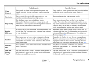 7
7 8
8 9
9 10
10 11
11 12
12 13
13 14
14 15
15 16
16 17
17 18
18 19
19 20
20 21
21 22
22 23
23 24
24 25
25 26
26 27
27 28
28 29
29 30
30 31
31 32
32 33
33 34
34 35
35 36
36 37
37 38
38 39
39 40
40 41
41 42
42 43
43 44
44 45
45 46
46 47
47 48
48 49
49 50
50 51
51 52
52 53
53 54
54 55
55 56
56 57
57 58
58 59
59 60
60 61
61 62
62 63
63 64
64 65
65 66
66 67
67 68
68 69
69 70
70 71
71 72
72 73
73 74
74 75
75 76
76 77
77 78
78 79
79 80
80 81
81 82
82 83
83 84
84 85
85 86
86 87
87 88
88 89
89 90
90 91
91 92
92 93
93 94
94 95
95 96
96 97
97 98
98 99
99 100
100 101
101 102
102 103
103 104
104 105
105 106
106 107
107 108
108 109
109 110
110 111
111 112
112 113
113 114
114 115
115 116
116 117
117 118
118 119
119 120
120 121
121 122
122 123
123 124
124 125
125 126
126 127
127 128
128 129
129 130
130 131
131 132
132 133
133 134
134 135
135 136
136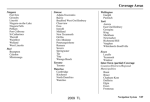 137
137 138
138 139
139 140
140 141
141 142
142 143
143 144
144 145
145 146
146 147
147 148
148 149
149 150
150 151
151 152
152 153
153 154
154 155
155 156
156 157
157 158
158 159
159 160
160 161
161 162
162 163
163 164
164 165
165 166
166 167
167 168
168 169
169 170
170 171
171