Page 59 of 237
INFO:
You can also set the orientation of the map using
the following procedure.
1. Press the SETUP button.
2. Touch the “Navigation” key.
3. Touch the “Map View” key.
CHANGING THE 3D (Birdview™)
ANGLE
This changes the 3D angle. This setting is only
available in the 3D mode.1. While in the 3D (Birdview™) map view,
touch the
key orkey to change
the angle of the map.You can also set the 3D (Birdview™) angle using
the following procedure.
1. Press the SETUP button.
2. Touch the “Navigation” key.
3. Touch the “Map View” key.
4. Touch the “3D” key.
5. Touch the
key orkey to
change the angle of the map.
LNV0128LNV0143LNV0128
Map settings3-15
ZREVIEW COPYÐ2008 Altima(alt)
Navigation System OMÐUSA_English(nna)
03/06/07Ðarosenma
X
Page 60 of 237
Some landmarks in the surrounding area can be
displayed as icons on the screen.
DISPLAYING LANDMARK ICONS
This allows you to display or hide the landmark
icons by type.
Landmark icons that can be displayed:
cRestaurant
cGas station
cHotel
cAT M
cRest area1. Touch the “MENU” key while the current lo-
cation map screen is displayed.2. Touch the “Landmark Icons” key.
LNV0130LNV0145
MAP ICONS
3-16Map settings
ZREVIEW COPYÐ2008 Altima(alt)
Navigation System OMÐUSA_English(nna)
03/06/07Ðarosenma
X
Page 61 of 237
3. Touch the preferred icon by touching the
“ON” key.
The icon display setting toggles on and off
each time you touch the “ON” key. The indi-
cator of the selected icon illuminates.4. Press the MAP button or the “Back” key.
The activated landmark icons are displayed
on the map.INFO:
You can also set the landmark icons using the
following procedure.
1. Press the SETUP button.
2. Touch the “Navigation” key.
3. Touch the “Landmark Icons” key.
MAP SYMBOLS
The navigation system uses symbols to display
facilities.
LNV0146LNV0147LNV0148
Map settings3-17
ZREVIEW COPYÐ2008 Altima(alt)
Navigation System OMÐUSA_English(nna)
03/06/07Ðarosenma
X
Page 62 of 237
2D icons (Plan View)
LNV0545
3-18Map settings
ZREVIEW COPYÐ2008 Altima(alt)
Navigation System OMÐUSA_English(nna)
03/06/07Ðarosenma
X
Page 63 of 237
3D icons (Birdview™)
LNV0546
Map settings3-19
ZREVIEW COPYÐ2008 Altima(alt)
Navigation System OMÐUSA_English(nna)
03/06/07Ðarosenma
X
Page 64 of 237
Road color
The road types are differentiated by colors.
Freeway: Red
Main road: Yellow
Narrow street: Gray
Road with incomplete map data: Green
XMTNAVTRAFFIC™ SYMBOLS
When displaying the map with XMTNavTraffic™
(if so equipped) enabled the following might be
displayed:
cColored road meanings:
– Green: Light traffic.
– Yellow: Heavy traffic and moving at ap-
proximately 21 MPH (34 km) to 44 MPH
(71 km) .
– Red: Traffic jam or accident and moving
at approximately 20 MPH (30 km) to 0
MPH (0 km) .
– Purple: Road closed.
cRoad symbol meanings:
: Accident
: Closed Road
: Information
: Road Work
: Slippery Road
: Weather
: Incident
3-20Map settings
ZREVIEW COPYÐ2008 Altima(alt)
Navigation System OMÐUSA_English(nna)
03/06/07Ðarosenma
X
Page 65 of 237

4 Setting a destination
Destination screen.................................4-2
Basic operation................................4-2
Setting a street address/residence as the
destination........................................4-3
Changing/setting a region.......................4-4
Setting a street address.........................4-4
Setting a city center............................4-7
Setting an intersection.........................4-10
Setting from map..............................4-13
Setting a stored location as the destination..........4-15
Setting your home.............................4-15
Setting from the address book as a
destination....................................4-16
Setting a previous destination...................4-18Setting the previous starting point...............4-19
Setting a facility as the destination..................4-21
Setting a point of interest.......................4-21
Category list..................................4-28
Setting a freeway entrance/exit..................4-31
Setting by phone number.......................4-34
Setting a nearby place.........................4-35
Operations after setting a destination...............4-37
Available setting items.........................4-38
Adjusting the location of the destination..........4-38
Adding additional destination to a route..........4-39
Viewing information about the searched
location......................................4-40
Storing a location..............................4-41
ZREVIEW COPYÐ2008 Altima(alt)
Navigation System OMÐUSA_English(nna)
03/13/07Ðarosenma
X
Page 66 of 237

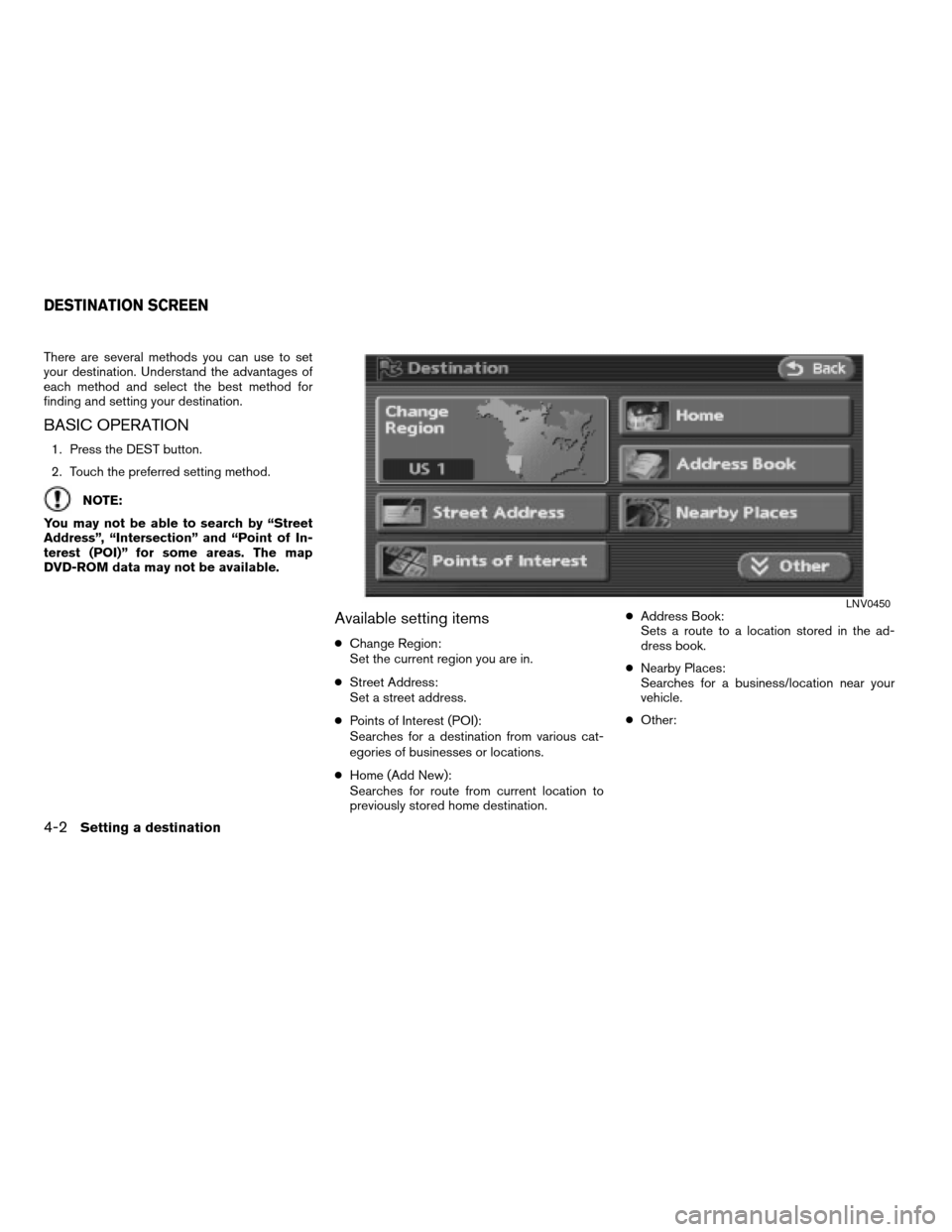
There are several methods you can use to set
your destination. Understand the advantages of
each method and select the best method for
finding and setting your destination.
BASIC OPERATION
1. Press the DEST button.
2. Touch the preferred setting method.
NOTE:
You may not be able to search by “Street
Address”, “Intersection” and “Point of In-
terest (POI)” for some areas. The map
DVD-ROM data may not be available.
Available setting items
cChange Region:
Set the current region you are in.
cStreet Address:
Set a street address.
cPoints of Interest (POI):
Searches for a destination from various cat-
egories of businesses or locations.
cHome (Add New):
Searches for route from current location to
previously stored home destination.cAddress Book:
Sets a route to a location stored in the ad-
dress book.
cNearby Places:
Searches for a business/location near your
vehicle.
cOther:
LNV0450
DESTINATION SCREEN
4-2Setting a destination
ZREVIEW COPYÐ2008 Altima(alt)
Navigation System OMÐUSA_English(nna)
03/06/07Ðarosenma
X