Page 179 of 242
 sof")
177 Navigation*
Route guidance
�Press any soft key.
The soft key displays appear.
Altering the map scale
The current map scale is indicated on the
left side of the status bar.
�Press the + or ) soft key.
The map section is zoomed in or
zoomed out. A bar indicating the map
scale appears on the status bar.Selecting map orientation
A symbol is shown on the bottom left side
of the status bar.
�Heading Up <:
Dynamic map alignment, map is
displayed facing driving direction
pointing up
or
�North Up Y:
Map is displayed facing north
You can select the map orientation
(
�page 193).
Changing the map display
While route guidance is active, you can
switch between split view and full view.
�Split view:
The map is shown on the left side and
information on the next maneuver on
the right.
or
�Full view:
Full view of the map.
�Press c.
The display changes with every push of
the button.i
If no other action is taken within
approx. 8 seconds, the soft key
displays will disappear again.
i
Depending on which option is selected
in the Display in Map screen
(
�page 194), the status bar indicates
�the estimated time of arrival and
the distance to destination
�GPS coordinates of the current
position or
�the road you are currently driving
on
Page 180 of 242

178 Navigation*
Route guidance
Usually COMAND guides you through fully
digitized areas on verified roads for as long
as possible. Route guidance is conducted
in the usual manner, i.e. with navigation
announcements and route guidance dis-
plays, map or split screen.
The DVD map may contain areas that are
only partially digitized with unverified
roads although they are within a digitized
region.Verified roads
�include information about the road’s
average speed, turning restrictions, or
whether it is a one-way street
�are typically roads within a
metropolitan area, interstate freeways
or major roads connecting cities
�enable reasonably accurate route
calculation and selection
Unverified roads
�are roads which lack the expected
road’s average speed and other
attributes
�could be smaller city streets and roads
either named incorrectly, have no
name or the name is shown in the
wrong location
�may not enable reasonably accurate
route calculation and selection
Partially digitized areas/unverified
roadsWarningG
Due to incomplete digitization, the route
shown on the map may differ from the actual
road/traffic situation.
If you follow the route shown on the map, for
example, it is possible that you could drive
the wrong way down a one-way street, that
a street cannot be driven on or that the road
is of questionable quality.
When using route guidance on a unverified
road in a partially digitized area, you must
therefore be sure to observe all relevant
traffic regulations and the course of the
road.
Drive carefully and keep in mind that all re-
levant traffic regulations and the course of
the road always take priority over the route
shown on the map.
Page 181 of 242

179 Navigation*
Route guidance
Route guidance in these areas
When you are
�entering a partially digitized area
or
�starting route guidance within such an
area,
the navigation system will inform you that
turn by turn guidance cannot be provided
with corresponding navigation displays
and voice announcements.Map display
Within these areas the display shows a
split screen with the map on the left-hand
side and a direction arrow on the right side
pointing to the destination instead of the
symbol for the next driving maneuver
(�page 180).
Route presentation
Usually the map highlights the active route
on verified roads with a blue line.
After route calculation, the route may
contain unverified road sections. Here, the
exact route guidance is suppressed and
these route sections will appear as blue
dotted lines. This type of line e.g. connects
two verified road sections, which are
displayed as blue lines or connects the end
of a verified road with a stopover or
destination located on an unverified road.
i
Displayed or audible distance to the
beginning of such an area is an
estimation. The actual distance may
differ.
WarningG
If the origin and destination are located very
close to each other, the system may not pro-
vide the shortest path to the destination
when you are travelling in an unverified area.
In most cases you will be directed to a veri-
fied road closest to the destination. This
may appear to be a long and unconvenient
route but it is safer. At your own risk, you
may choose to drive on the unverified roads
to the destination.
Page 182 of 242

180 Navigation*
Route guidance
Display examples are shown below:
1Road section known to the system
2Route section between the end of a
verified road and the destination on an
unverified roadIf the vehicle approaches a stopover or a
destination located on a unverified road,
the blue dotted line will disappear and a
red dotted line will appear. The line is your
dynamic reference, it moves with the
current vehicle location.
1Current vehicle location and direction
of travel y
2Reference line guides you to 3
3Destination on an unverified road $
4Arrow indicates the direction of the
destination, the distance to destination
and
OFF ROAD indicationThis type of line will also appear if you are
currently travelling on a unverified road
�to guide you back to a verified road
or
�to guide you to a stopover or
destination located on a unverified
road too.
If the vehicle reaches a verified road again,
the red dotted line will disappear and route
guidance will simply continue in the usual
manner.
i
Stopover and destination are located
on unverified roads:
The map highlights the route section
between a stopover and a destination
with a blue dotted line first. After the
vehicle reaches the stopover, then the
red dotted line will appear.
Page 183 of 242

181 Navigation*
Route guidance
Voice instructionsThe system inform you in the following
cases:
After route calculation
�Vehicle is on a verified road,
destination is on a unverified road
Your destination is located
in an area where turn by turn
guidance cannot be provided.
Guidance will stop if you
reach this area.
�Vehicle is on an unverified road
You are currently travelling
in an area where turn by turn
guidance cannot be provided.
Use the directional arrow to
guide you.
Approaching an unverified road section or
a stopover or destination on a unverified
road (series of messages):
You will be entering an area
where turn by turn guidance
cannot be provided.
You are about to enter an area
where turn by turn guidance
cannot be provided.
Use the directional arrow to
guide you.
i
Destinations and stopovers located in
unverified roads are entered in exactly
the same way as they are in verified
roads. Please refer to enter a
destination address (
�page 158) or a
stopover (
�page 188).
i
Usually, if you are travelling on
unverified roads, COMAND will not
generate usual navigation
announcements.
i
During route guidance, you will also
hear this message if you press j.
Page 184 of 242

182 Navigation*
Route guidance
OFF ROADIf there is no road shown on map at the
current position, the vehicle is OFF ROAD.
COMAND is able to guide you to an OFF
ROAD destination or from an OFF ROAD
location.
COMAND will inform you with the
OFF
ROAD
indication and the direction arrow
pointing to the destination. Corresponding
announcements may be audiable.
1Current vehicle OFF ROAD location and
direction of travel y
2Road known to the system, name is
shown above
3Arrow indicates the direction of the
destination and the distance to
destination
4
OFF ROAD indication
As soon as the vehicle is back on a road
known to the system, route guidance
continues in the usual way.
WarningG
The COMAND navigation system may direct
you to off-road routes that your vehicle may
not be capable of traversing through without
damaging your tires, wheels or vehicle. It is
the driver's sole responsibility to determine
the suitability of the route. Off-road routes
may be of varying conditions and their ap-
propriateness for use may be affected by va-
rious factors such as time of day, time of
year and immediate weather conditions that
cannot be judged or taken into considerati-
on by the COMAND system.
i
An OFF ROAD destination is not itselve
recorded on the map. You can enter an
OFF ROAD destination using the map,
for example (
�page 167).
Page 185 of 242

183 Navigation*
Route guidance
OFF MAP
If the vehicle position is outside the area
covered by the digital map, then the ve-
hicle is on a OFF MAP location. COMAND
is also able to guide you to a destination
from such a location.
COMAND will inform you with the
OFF MAP
indication and the direction arrow pointing
to the destination.
1Current vehicle OFF MAP location and
direction of travel y
2Arrow indicates the direction of the
destination and the distance to
destination
3OFF MAP indicationAs soon as the vehicle is back on a road
known to the system, route guidance
continues in the usual way.
When you reach the destination, you will
see the destination flag. Route guidance
ends.
�In navigation mode, press b.
The inquiry menu
Cancel route
guidance?
will appear.
�Press E to confirm Yes.
Route guidance is cancelled. The
Navigation main menu appears.
Continuing route guidance
�Push the joystick to h to select No.
�Press E.
Arriving at destination
Cancelling route guidance
i
You can continue route guidance from
the Navigation main menu
(
�page 152).
Page 186 of 242
184 Navigation*
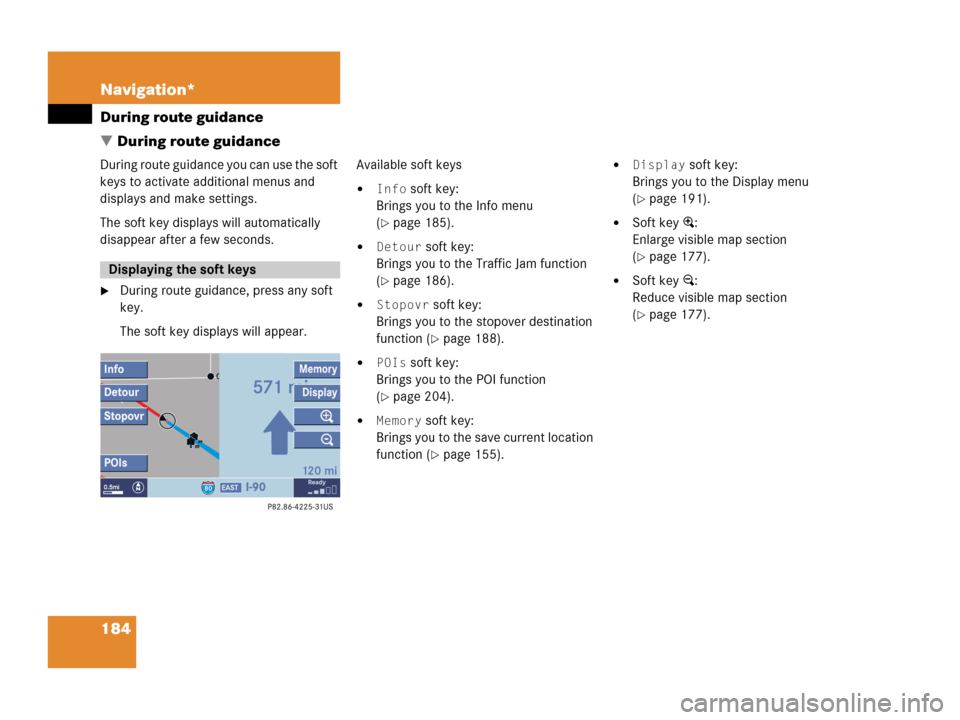
During route guidance
� During route guidance
During route guidance you can use the soft
keys to activate additional menus and
displays and make settings.
The soft key displays will automatically
disappear after a few seconds.
�During route guidance, press any soft
key.
The soft key displays will appear.Available soft keys
�Info soft key:
Brings you to the Info menu
(
�page 185).
�Detour soft key:
Brings you to the Traffic Jam function
(
�page 186).
�Stopovr soft key:
Brings you to the stopover destination
function (
�page 188).
�POIs soft key:
Brings you to the POI function
(
�page 204).
�Memory soft key:
Brings you to the save current location
function (
�page 155).
�Display soft key:
Brings you to the Display menu
(
�page 191).
�Soft key +:
Enlarge visible map section
(
�page 177).
�Soft key ):
Reduce visible map section
(
�page 177).
Displaying the soft keys