Page 33 of 52
Navigation31
– Turn the menu knob. All stretches of the route that are blocked will appear in green. Press the menu knob once you have
marked the route section in question. The display will be
switched to the map. You will hear an announcement that the
route is being calculated. The excluded stretch of the route will
be shown as a dotted blue line on the map.
– Press to delete the blocking function.
You will be guided through a blocked area if there is no logical alternative
to travelling through it.
Note
If you use a map CD which contains only major routes, you will have less
alternative routes than if you use a CD which contains minor roads. To
ensure that you do not have to make unnecessary detours, you should
use a map CD containing all roads when you wish to be guided around
congestion on the route.
Cancel exclusion option
sao.book Seite 31 Montag, 22. M‰ rz 2004 9:32 09
Page 34 of 52
Navigation
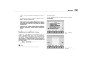
32Map and symbol displaysInformation in the map and symbol displays
Information on the route will be shown in the map or
symbol displays if the route guidance function is active.
– Press the button �Ÿpage 2, fig. 1 . The screen will
switch between map and symbol displays.Map display
Autozoom active (
�{ in orange). The scale of the map will, for
example, be larger for motorway driving and more detailed when
making a turn.
Journey time or arrival time
Distance to destination or stopover
Road name
Vehicle position - The black arrow points in the direction of travel. The
route ahead is shown as a blue line.
Route options and TMC:
�� If the dynamic route guidance option is active, the horizontal arrow
is shown with a D, and blocked roads are shown as
�‚.
F
D
E
C
A
G
B
HBra-0097
Fig. 37 Map display
A
B
E
C
G
D
F
Bra-0098
Fig. 38 Symbol display
MAP
A12
AAABACADAEAF
sao.book Seite 32 Montag, 22. M‰ rz 2004 9:32 09
Page 35 of 52
 Nexus Navigation System Manual Navigation33
��TMC: The number of TMC reports received is shown by the black
dots.
Map scale
North
Traffic problems are indicated by a symbol on the map:
�ƒ slow-moving traffic�w traffic jam�‚ clo")
Navigation33
��TMC: The number of TMC reports received is shown by the black
dots.
Map scale
North
Traffic problems are indicated by a symbol on the map:
�ƒ slow-moving traffic�w traffic jam�‚ closed road
Symbol display The number of GPS satellites
Route option (in this example dynamic route guidance D)
Arrival time or journey time
Distance to destination or stopover
Turn arrow, above it the name of the street you are turning into.
Current road
The proximity bar shows how far away the turning point is. The
distance to the next change of direction will be shown in the display
after you have turned.
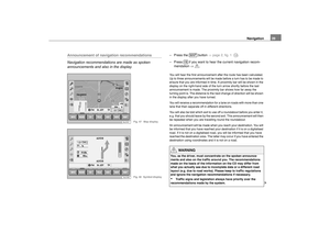
Changing the scale
You can choose from a total of 13 different scales.–Press or .
– More details. A scale display appears in the top left-hand corner
when the button is pressed �Ÿfig. 39
– Large overview. A scale display appears in the top left-hand corner
when the button is pressed.
The selected scale will be shown once the menu knob is pressed or after
3 seconds.
AGAHAAABACADAEAFAG
Map scale
Bra-0099
Fig. 39 Changing the
scale
�ˆ
�}
�ˆ�}
sao.book Seite 33 Montag, 22. M‰ rz 2004 9:32 09
Page 36 of 52
 Nexus Navigation System Manual Navigation
34Changing display options
The map type and display can be selected, although some
settings cannot be seen until active route guidance has
started.–Press �Ÿpage 32, fig. 37 to chan")
Navigation
34Changing display options
The map type and display can be selected, although some
settings cannot be seen until active route guidance has
started.–Press �Ÿpage 32, fig. 37 to change the display options.�x
location – Shows your position on the map.
�x
destin. – Shows the area surrounding your destination.
�x
overview – Shows the entire route.
The map will always be shown in the direction North at the top if you have
chosen the map type overview or destin. . In the map display option auto,
a detail map (up to 2 km per cm) with the direction of travel at the top and
an overview map (as of 5 km per cm) with North at the top will be shown.
�x
auto – The system selects the map display.
�x
travel – The display always adjusts to the direction of travel.
�x
north – North is always at the top of the display.
�x
high – Smaller scales are given priority for the automatic scale selec-
tion.
�x
low – Larger scales are given priority for the automatic scale selection.
The settings for Autozoom will only take effect if
�{ is pressed in the map
display �Ÿpage 32, fig. 37 .
�x
travel t. – Shows the remaining travel time.
�x
arrival – Shows the estimated arrival time �Ÿ page 32, fig. 37 .
auto
Set-upAutozoom
back with ESC
detailed overview
travel
location
Syst. settings Time format
widedest.
arrival
travel t. north
Map type
Alignment
Bra-0100
Fig. 40 Display
options
�
Map typeAlignment
Autozoom
AA
Time format
AB
sao.book Seite 34 Montag, 22. M‰ rz 2004 9:32 09
Page 37 of 52
Navigation35
Traffic reports display
Short texts of traffic reports that have been received can
be called up from a list.– Press in the map display �Ÿpage 32, fig. 37 .
– Or press and .
– Turn the menu knob to move the orange bar to the traffic report you are interested in.
– Press to see the full text of the traffic report.
Moving the map section using the crosshair– Press in the map display �Ÿpage 32, fig. 37 to call up the
shift function.
– Using the right-hand function keys or by turning/pressing the menu knob, move the the crosshair to the destination of your
choice.
– Use the scale modifications to adapt the display to suit your requirements �Ÿpage 33.The neighbouring map section will be displayed if you move the crosshair
to the side of the screen. This procedure can take some seconds.
TMC travel info
back with ESC
Travel inform.
Bra-0101
Fig. 41 Traffic reports
�‰
INFO
Travel info
�±
Bra-0102
Fig. 42 Crosshair
�|
sao.book Seite 35 Montag, 22. M‰rz 2004 9:32 09
Page 38 of 52
 Nexus Navigation System Manual Navigation
36Augmenting map contents
A range of symbols can be used to display additional map
content.– Press in the map display �Ÿpage 32, fig. 37 .
– Turn the menu knob or use the right-han")
Navigation
36Augmenting map contents
A range of symbols can be used to display additional map
content.– Press in the map display �Ÿpage 32, fig. 37 .
– Turn the menu knob or use the right-hand function keys to move the orange bar to the map detail you are interested in.
– Press the menu button or . A "tick" will appear next to the map detail.
NoteYou can lose the overview of the map if too many map details are
selected.
Route list
The route list is a list of all route sections which will be trav-
elled through with active route guidance.– Press in the map display �Ÿpage 32, fig. 37 to see the
route sections of your current journey.The route list is updated during the journey. It shows the roads that you
have not yet reached. Route sections that you have already travelled will
be deleted from the route list.
Note
It takes some seconds after route guidance has started for the route list to
be compiled so that it can be displayed.
Map content
Ferry Shopping centreTrain station
Car rental
Motorway service st.
Motorway exit
back with ESC
Exhibition centre
Map content
Bra-0103
Fig. 43 Map contents
�†
OK
Route list
back with ESC
Route list
Bra-0104
Fig. 44 Route list from
the map
�²
sao.book Seite 36 Montag, 22. M‰
rz 2004 9:32 09
Page 39 of 52
 Nexus Navigation System Manual Navigation37
Position display
The current information on the position of the vehicle is
shown here.
GPS status (number of satellite receptions, positioning mode)
including the direction and distance")
Navigation37
Position display
The current information on the position of the vehicle is
shown here.
GPS status (number of satellite receptions, positioning mode)
including the direction and distance to destination (with active route
guidance).
Direction of travel
Altitude (GPS altitude). If too few satellites are received to calculate
the altitude, the display is green.
�v
GPS position (longitude)
�
GPS position (latitude)
The direction of travel is shown in degrees and also in the form of a
compass.
The GPS status shows the number of satellites as dots and also shows
the positioning mode (NO FIX, 2D FIX, 3D FIX).
�x
NO FIX – The GPS reception is not sufficient to fix the position of the
vehicle.
�x
If the position definition for NO FIX is only possible using the wheel
sensors (underground garage etc), the GPS coordinates will be displayed
in green. The GPS coordinates will no longer be shown following a long
distance with NO FIX in the display or if it is not possible to determine the
position.
�x
2D FIX – The horizontal position of the vehicle can be determined, but
not the altitude (altitude display is green).
�x
3D FIX – Position and altitude can be determined.
The altitude given is accurate to �r15 m at altitudes between 0 m and
+5000m. The system will be less accurate if the GPS reception is bad or
weather conditions are poor.
The direction to the destination is shown in the form of a marking outside
the compass. If the destination is not in the area displayed by the compass
(i.e. to the side or behind the vehicle), the marking is shown as an arrow
to the side in question.
Position displ. back with ESC
Compass
A
B
C
Bra-0105
Fig. 45 Position
display
AAABAC
sao.book Seite 37 Montag, 22. M‰
rz 2004 9:32 09
Page 40 of 52
Navigation
38Route guidanceStarting/stopping route guidance– Press . You will hear an announcement that the
route is being calculated. The radio navigation system will
automatically switch to the map display.
– Press the button to return to the Navigation main menu.
– Press if you wish to stop the route guidance
function before you have reached your destination.The route guidance function can only be started if you have already
entered a destination.
Note
�x
You should drive on a bit further if the system makes the announce-
ment that you are not on a digitalised street before starting route guidance.
The unit might have to orientate itself using the next main road.
�x
The active route guidance function will be interrupted if a stopover
destination is entered.
Route opt.Destination
Stopover
Set-up
Stop route gd.
Exhibition centre Destination
Bra-0106
Fig. 46 Ending route
guidance
Start route gd.
NAVI
Stop route gd.
sao.book Seite 38 Montag, 22. M‰
rz 2004 9:32 09


 Nexus Navigation System Manual Navigation31
– Turn the menu knob. All stretches of the route that are blocked will appear in green. Press the menu knob once you have
marked the route section in question. The display will be
sw")
 Nexus Navigation System Manual Navigation
32Map and symbol displaysInformation in the map and symbol displays
Information on the route will be shown in the map or
symbol displays if the route guidance function is active.
– Press")
 Nexus Navigation System Manual Navigation35
Traffic reports display
Short texts of traffic reports that have been received can
be called up from a list.– Press in the map display �Ÿpage 32, fig. 37 .
– Or press and .
�")
 Nexus Navigation System Manual Navigation
38Route guidanceStarting/stopping route guidance– Press . You will hear an announcement that the
route is being calculated. The radio navigation system will
automatically switch to the")