Page 37 of 167

CAUTION
�Close the display while driving to
prevent injury in an accident or
sudden stop.
�Do not put any object on the open
display screen.
�Do not allow the system to get wet.
Excessive moisture such as
spilled liquids may cause the sys-
tem to malfunction.
SETTING UP THE START-UP
SCREEN
When you turn the ignition key to ACC, the fol-
lowing warning is displayed on the screen:
Read the warning and select the
ENTER key .
INFO:
�If you do not touch the
ENTER key , this
system will not proceed to the next step dis-
play .
�If you do not use the navigation system,
press the OFF button for the display .�When the engine is turned off during route
calculation and then turned on, the [CON-
FIRMA TION OF DEST ./WA YPOINT] screen
will be displayed after the [SYSTEM
ST ART -UP] screen. When continuing the
previous route guidance, select the
OK
key . T o edit or delete, select the
Change
key .
CLEARING THE MEMORY
All the stored data (Address Book, Avoid Area,
Previous Dest) can be cleared.
1. Change to the current vehicle location
screen.
2. Select the
Setting key .
INV0487
HOW DO I OPERATE THE NISSAN NAVIGATION SYSTEM?
4-12
Page 39 of 167

NOTES ON ROUTE GUIDANCE
�The route selected by the system may not
be the shortest, nor are other circumstances
such as traffic jams considered.
�Because of the inevitable difference in road
conditions and circumstances between the
time you use this system and the time the
information was produced from the CD,
there may be discrepancies in roads and
regulations. In such cases, follow the actual
information available.
�During route calculation, the map will not
scroll, however the vehicle icon will move
with the actual vehicle’s movement.
�During route calculation, buttons such as
MAP , DEST , ZM− and ZM+ and
the joystick will be disabled.
�In some cases, after the calculation is com-
plete, it may take some time to get the cal-
culated route on the display .�Waypoints that have been passed will not
be covered by the re-routing calculation.
�If you scroll the map while the suggested
route is being drawn, it may take more time
to finish drawing.
�If waypoints are set, the system is calculat-
ing multiple routes between waypoints si-
multaneously , and the following may result.
— If one section (or more) of the routes be-
tween the waypoints is not found, none of
the route will be displayed.
— The route may not connect completely at
some waypoints.
— The route may require a U-turn close to
some waypoints.
�Route calculation may not be completed in
the following cases.
— If there is no main road within 3.1 miles (5
km) from the vehicle, a message saying so
will appear on the screen. T ry requestingroute calculation when the vehicle is closer
to the main road.
— If there is no main road within 3.1 miles (5
km) from the destination or waypoint, a
message saying so will appear on the
screen. T ry setting the location closer to the
main road.
— If the vehicle is too close to the destination
or if there are no branches of the roads to
the destination. A message saying so will
appear on the screen.
— If it is deemed impossible to reach the des-
tination or waypoints because of traffic
regulations, etc.
— If there is only an extremely complicated
route to reach the destination or waypoints.
— If the destination, current vehicle position
or waypoint is within the
avoid area.
— If the setting of
avoid areascovers the
routes to the destination, route calculation
HOW DO I OPERATE THE NISSAN NAVIGATION SYSTEM?
4-14
Page 40 of 167

may not be possible.
�The following may occur when the route is
being displayed.
— Even if you are requesting calculation from
the main road, the origin of the route may
not exactly match the current vehicle posi-
tion.
— Even if you are requesting calculation to the
destination on the main road, the end of the
route may not exactly match the destination.
— Even if you are requesting calculation from
the main road, the system may show a route
from another main road. This may be be-
cause the icon to show the current vehicle
position (vehicle icon) is not set accurately .
In that case, park the car in a safe place and
reset the vehicle icon, or continue driving
to see if the vehicle icon appears on the
main road before requesting route calcula-
tion again.
— There are cases in which the system showsa detoured route to reach the destination or
waypoints, if you set them from memory or
facility information. In order to correct this,
you will have to be careful about the traffic
direction, especially when the lanes with
different travel directions are shown sepa-
rately . Such places are interchanges and
service areas.
— This system makes no distinction between
limited traffic control and total control
(blockage). It may show a detoured route
even if the road is usable.
— Even if the freeway preference is set to OFF ,
the route may be set on them. T o avoid this,
set a waypoint on another road type and re-
quest calculation.
— Even if the preference is set as OFF for a
ferry line, the route may be set on it. T o
avoid this, set a waypoint on a road and re-
quest calculation.
— Ferry lines, except those which accept onlypedestrians, bicycles and motorcycles, are
stored in this system. When using them,
take into consideration the travel time re-
quired and operational condition to decide
whether to use them or not.
ABOUT THE DISPLAY ERROR
The following cases may affect the display ac-
curacy of the vehicle’s position or travel direc-
tion. The accuracy will return to normal if the
driving conditions return to normal.
— When there is a similar road nearby .
— When the vehicle is traveling on a long
stretch of straight road or series of curves
with a large radius.
— When the vehicle is traveling in an area with
a checkerboard road system.
— When the vehicle is making consecutive S
curves.
— When the vehicle is at a large Y -shaped
junction.
HOW DO I OPERATE THE NISSAN NAVIGATION SYSTEM?
4-15
Page 43 of 167

WARNING
T o operate the navigation system or
to use the screen functions, first park
the vehicle in a safe place and set the
parking brake. Usin")
V ARIOUS W A YS TO SET
THE DESTINA TION (OR
W A YPOINT)
WARNING
T o operate the navigation system or
to use the screen functions, first park
the vehicle in a safe place and set the
parking brake. Using the system
while driving can distract the driver
and may result in a serious accident.
SEVEN CATEGORIES
T o set the destinations and waypoints, you can
choose from the seven categories described
below. Use these options to choose the best
way to find the route to the destinations and
waypoints.
�Address Book
�Previous Dest.
�Address/Street
�Intersection�Point of Interest (POI)
�City
�Map
INFO:
�If you set destinations or waypoints, they
will be displayed with icons.
�If you want to go to places close to the
stored locations or facilities, use categories
such as facility , nearby facility or memory
for easier setting.
�When using either the Point of Interest
(POI) or nearby Points of Interest catego-
ries, the names called up can be set as the
destination if you do not scroll the screen.
If you want to choose a different place on
the screen from the one called up, you will
have to scroll the screen.
INV0271
HOW DO I PROGRAM A DESTINATION?
5-2
Page 44 of 167
SETTING WITHAddress BookKEY
The Address Book will allow you to store lo-
cations in the memory . This is especially useful
for locations that you visit frequently .
Please refer to “Setting up and editing the ad-
dress book” on page 7-2.
1. Press the DEST button.
2. Select the
Address Book key on the
[DEST . SETTING] screen.The [DEST . SETTING (Address book)] screen
will be displayed.
3. Select the item key of your destination
(waypoint) on the [DEST . SETTING (Ad-
dress Book)] screen to display the [DEST .
SETTING] screen.4. T o set the destination (waypoint), select
route priorities and select
OK . Refer to
“Making the system guide the route with
detailed options” on page 5-17.
INFO:
Use the joystick or the
orkey to scroll
the display .INV0272
INV0273
INV0274
HOW DO I PROGRAM A DESTINATION?
5-3
Page 45 of 167
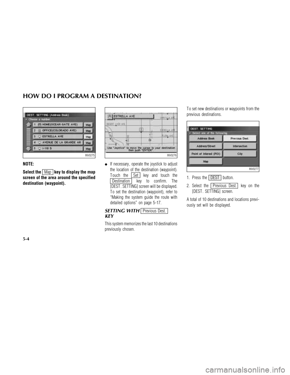
NOTE:
Select the
Mapkey to display the map
screen of the area around the specified
destination (waypoint).�If necessary , operate the joystick to adjust
the location of the destination (waypoint).
T ouch theSet key and touch the
Destination key to confirm. The
[DEST . SETTING] screen will be displayed.
T o set the destination (waypoint), refer to
“Making the system guide the route with
detailed options” on page 5-17.
SETTING WITHPrevious Dest.
KEY
This system memorizes the last 10 destinations
previously chosen.T o set new destinations or waypoints from the
previous destinations.
1. Press the DEST button.
2. Select the
Previous Dest. key on the
[DEST . SETTING] screen.
A total of 10 destinations and locations previ-
ously set will be displayed.
INV0275INV0276
INV0277
HOW DO I PROGRAM A DESTINATION?
5-4
Page 46 of 167
3. Select the item key of your destination
(waypoint) on the [DEST . SETTING (Previ-
ous Dest.)] screen to display the [DEST .
SETTING] screen.4. T o set the destination (waypoint), select
route priorities and select
OK . Refer to
“Making the system guide the route with
detailed options” on page 5-17.NOTE:
T o slightly after the destination, select
the
Mapkey to display the map screen
of the area around the specified desti-
nation (waypoint).
INV0278INV0274INV0279
HOW DO I PROGRAM A DESTINATION?
5-5
Page 47 of 167
![NISSAN MAXIMA 2003 A33 / 5.G Navigation Manual 5. If necessary , operate the joystick to adjust
the location of the destination (waypoint).
T ouch the
Setting key and touch the
Destination key to confirm. The
[DEST . SETTING] screen will be displa](/manual-img/5/662/w960_662-46.png "NISSAN MAXIMA 2003 A33 / 5.G Navigation Manual 5. If necessary , operate the joystick to adjust
the location of the destination (waypoint).
T ouch the
Setting key and touch the
Destination key to confirm. The
[DEST . SETTING] screen will be displa")
5. If necessary , operate the joystick to adjust
the location of the destination (waypoint).
T ouch the
Setting key and touch the
Destination key to confirm. The
[DEST . SETTING] screen will be displayed.
T o set the destination (waypoint), refer to
“Making the system guide the route with
detailed options” on page 5-17.
SETTING WITHAddress/Street
KEY
Sets the destination (waypoint) from the street
names and addresses that you enter .There are two search methods; direct search by
the street names, and search by the street
names after a city is defined.
1. Press the DEST button.
2. Select the
Address/Street key .
NOTE:
The location displayed using the house
number is the vicinity of the locations
corresponding to the house numbers
stored in the data. It may differ from the
actual location.3. A keyboard will be displayed on the [DEST .
SETTING (Address/Street)] screen. Enter
the street name you want to set.
INFO:
It is not possible to enter names if they are not
stored in the CD-ROM.
INV0284
INV0280
INV0281
HOW DO I PROGRAM A DESTINATION?
5-6

![NISSAN MAXIMA 2003 A33 / 5.G Navigation Manual 3. Select the item key of your destination
(waypoint) on the [DEST . SETTING (Previ-
ous Dest.)] screen to display the [DEST .
SETTING] screen.4. T o set the destination (waypoint), select
route prior](/manual-img/5/662/w960_662-45.png "NISSAN MAXIMA 2003 A33 / 5.G Navigation Manual 3. Select the item key of your destination
(waypoint) on the [DEST . SETTING (Previ-
ous Dest.)] screen to display the [DEST .
SETTING] screen.4. T o set the destination (waypoint), select
route prior")