Page 17 of 48
.
²If a larger number of facilities is availab")
²This option may be limited in cities or towns which are not yet
completely mapped.
3. CHOOSE the desired category (for example Hotel, Gas Station, ...).
²If a larger number of facilities is available in the data base, the
ªkeyboardº is shown.
4. Enter the name of the desired facility or choose ªListº.
5. CHOOSE the desired facility from the list.
Facilities of major importance (e.g. airports, ferries etc.)
If you are searching for facilities of major importance (i.e., airports,
park/recreation, fitness):
1. CHOOSE ªPoints of interestº from the Navigation Menu.
2. CHOOSE ªNation. importanceº.
3. CHOOSE the desired category. If a large number of facilities are
available in the database, the ªkeyboardº is shown.
4. Enter the name of the desired facility or choose ªListº
5. CHOOSE the desired facility from the list.
Note:some map CDs may not support the ªNational importanceº option.
In this case, enter a city as the destination address and CHOOSE the
ªInfo on dest.º option to search for facilities of major importance in a
city.
Points of interest located around the current car position
When searching for points of interest in the vicinity of your current
vehicle position:
1. CHOOSE ªPoints of interestº from the Navigation menu.
2. CHOOSE ªInfo on car pos.º. A list of categories specifying the points
of interest located around the current vehicle position is displayed.
3. CHOOSE the desired category.
4. Either enter the name of the desired facility, or CHOOSE ªListº.
In the list of points of interest, an arrow behind the list entry shows you
the direction to where the destination is located. In addition, the
distance to the destination is shown.
The points of interest are sorted in order of their distance from the
current vehicle position, for example, the nearest facility is on top of the
list.
Navigation menu
17
Page 18 of 48

Facilities outside the mapped area
With some map CDs, it is possible that the roads leading to a point of
interest you previously selected are not or only partly mapped on the
map CD.
²As long as the roads are mapped, the navigation system will guide you
in the direction of your destination. As soon as you leave the mapped
area, the system will show you a map with the area around your
current position as well as the directional arrow and the distance to
the destination.
Destination input by map
If the road name or a special
location within the city you want to
travel to is not known, or if you
want to specify the destination more
precisely, you can enter the
destination using the map.
Destination input by map is not
possible when the vehicle is moving.
²CHOOSE ªDestination mapº from the Navigation menu and confirm
your selection.
²A map with the area around the specified destination address is
shown. If no destination was entered before, a map with the area
around the current vehicle position is displayed.
²Press ENTER.
A menu appears in the upper left corner of the screen with the following
functions:
²Return:Returns you to the Navigation menu.
²Scale:To change the map scale.
²Store:To store the position underneath the white the X/Y axis as a
destination.
²Back to position:Brings back the map of the area surrounding your
vehicle.
²X/Y axis:Lets you to switch between the X and Y axis.
Navigation menu
18
Page 19 of 48

GUIDANCE SCREEN
Once you select ªGuidanceº, either
the guidance screen or the map will
appear. If you are on a digitized
road, the guidance screen will
appear. Otherwise, the map will
appear.
In case you entered a new
destination address, it may take
some time before the first guidance
advice is shown. The navigation system plans the route. During route
planning and hourglass appears in the status line. The following is the
information offered by the guidance screen:
1. Current vehicle position: Road name, city name and county name if
stored in the database.
2. Visual guidance advice: Diagram of the next intersection or turn. In
addition, direction changes are announced by voice messages.
3. GPS reception status: When the GPS receiver receives valid data, the
color of the satellite icon changes from red to green.
4. Next maneuver. The next road you have to turn onto.
5. Distance to the next direction change.*
6. Function opens a pull down list with three options: ªReturnº (for Start
Menu) or ªMapº (for route map) or ªInfoº (for Route Information Menu)
7. Target direction arrow. Shows the ªas the crow fliesº direction to the
selected destination.
8. Distance to the destination.* (real driving distance once a route is
planned).
9. Status line.
* The measuring units are dependent on the system settings. Refer to
theSystem settingssection.
Guidance
19
Page 20 of 48
Guidance with a route map
If ªMapº option is chosen from the
guidance screen, or the ªMAPº
button is pressed, the route map
appears on the display.
1. Distance to the next direction
change*
2. GPS reception status: When the
GPS receiver receives valid data, the
color of the satellite icon changes
from red to green.
3. Simplified visual guidance advice. In addition, direction changes are
announced by voice messages.
4. Function button. See below.
5. Shows your position: The vehicle
position is shown as a circle with a
directional arrow. The planned route
is shown in white.
6. Compass: Shows the north
direction
Guidance
20
Page 21 of 48

²Press ENTER to open a menu with the following options:
Return:Back to the guidance screen.
Scale:Changes the scale of the map. Confirm ªScaleº by pressing
ENTER, and choose the scale by rotating the rotary control. Confirm the
new scale by pressing ENTER again.
Positioning:Selects the orientation of the map (ªNorthwardsº or ªHead
upº). The map is displayed in ªHead upº mode only if the map scale is
100 m, 200 m, 500 m and 1 km (400 ft, 800 ft, 1/4 mile or 1/2 mile). Any
scale larger, and the map displays ªNorthwardsº only. Selecting
ªHead-upº will switch off scrolling.
Scrolling:Switches on and off the soft-scrolling mode. The vehicle
position will stay in the middle of the screen while the map is moving
(soft scrolling). underneath the vehicle. The check box indicates if it is
switched on or off. Soft scrolling mode is only available in north heading.
Info:Displays the Info Menu. You may display or change route criterion.
The following menu options are available:
²Route list:Shows a list of all sections of the planned route. (Only if
you are on a mapped road).
²Next via point:Shows the next via point and gives you the
possibility to delete this via point.
²Route selection:To select the route planning criterion. Refer to
Route Selection.intheSystem settingssection of this manual.
²Return:Back to the guidance screen.
Split scr.:Displays the guidance screen on the right side of the display
and the map on the left side. If no selection is made within
approximately seven seconds, the menu is automatically closed.
Guidance
21
Page 22 of 48
. When the vehicle leaves
the mapped road, the system
automatically changes from the
g")
Guidance in partly mapped areas
In rural areas and smaller cities, not
every road is mapped (stored on the
map CD). When the vehicle leaves
the mapped road, the system
automatically changes from the
guidance screen to map display at
the 1/2 mile scale.
²Drive in direction of a displayed (mapped) road, if route guidance is
desired.
²As soon as the mapped road is reached, the system switches back to
guidance and plans a new route.
Automatic re-routing
If the guidance advice is not followed, the advice is missed, or it is not
possible to follow the advice due to traffic demands, the system will
automatically plan a new route within a few seconds.
Adjustment of the average speed setting
The navigation system uses the average speed of the vehicle by default
for calculating the remaining travel time and the estimated time of
arrival. The average speed can be adjusted if the displayed times (time
of arrival or remaining travel time) are consistently different from what
you experience. Please refer to theSystem informationsection of
System settings.
Guidance
22
Page 23 of 48
.
This function can be used to get
around traff")
ALTERNATIVE ROUTE / DETOUR
The navigation system can calculate
an alternative route only during
guidance for an adjustable distance,
e.g.1-10km(1-6miles).
This function can be used to get
around traffic jams or if you do not
agree with the current route
planning of the navigation system.
The alternative route is calculated
from the current vehicle position for
the selected distance.
1. Press ªDETOURº button.
²The ªAlternative Routeº menu is displayed and the cursor is placed on
ªYesº.
2. If you agree with the displayed distance, confirm by pressing ENTER.
3. If you wish to change the distance, CHOOSE the distance data field.
4. Select the minimum distance between 1-10 km (1-6 miles) for the
alternative route you want to be planned by the navigation system.
5. Confirm the selected distance by pressing ENTER.
6. Confirm the procedure by selecting ªYesº and pressing ENTER.
²An alternative route is calculated for the chosen distance within a
short period of time.
7. If you do not want an alternative route, cancel the operation by
selecting ªNoº on the display.
Even without the alternative route function, the navigation system plans
a new route automatically when you leave the advised route.
Alternative route / Detour
23
Page 24 of 48

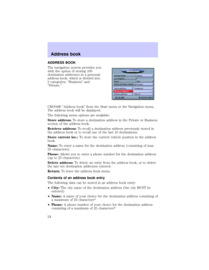
ADDRESS BOOK
The navigation system provides you
with the option of storing 100
destination addresses in a personal
address book, which is divided into
2 categories: ªBusinessº and
ªPrivate.º
CHOOSE ªAddress bookº from the Start menu or the Navigation menu.
The address book will be displayed.
The following menu options are available:
Store address:To store a destination address in the Private or Business
section of the address book.
Retrieve address:To recall a destination address previously stored in
the address book or to recall one of the last 10 destinations.
Store current loc.:To store the current vehicle position in the address
book.
Name:To enter a name for the destination address (consisting of max.
25 characters).
Phone:Allows you to enter a phone number for the destination address
(up to 25 characters).
Delete address:To delete an entry from the address book, or to delete
the last ten destination addresses entered.
Return:To leave the address book menu.
Contents of an address book entry
The following data can be stored in an address book entry:
²City:The city name of the destination address (the city MUST be
entered)
²Name:A name of your choice for the destination address consisting of
a maximum of 25 characters*
²Phone:A phone number of your choice for the destination address
consisting of a maximum of 25 characters*
Address book
24