Page 91 of 246

90
CONNECT Nav
GENERAL
INFORMATION
The navigator integrated in the
CONNECT system allows you to
reach the chosen destination by visu-
al and voice instructions. Use of the
navigation system is quick, convenient,
safe and above all very flexible because
it allows you to call up already pro-
grammed destinations or points of ref-
erence such as hotels, monuments,
public structures, fuel stations orFi-
at Dealerships.
The vehicle position is determined
through the GPS system (Global Posi-
tioning System) installed on the vehi-
cle. The GPS system is fitted with an
antenna and a reception module inte-
grated in the telematic system. This
system configuration dynamically
processes the satellite signals and
those provided by the vehicle system,
integrating them with the current po-
sition of the vehicle to obtain an “es-
timated vehicle point”.The navigation system helps the dri-
ver while he drives by suggesting vo-
cally and graphically the optimum rout-
ing to reach the preset destination.
The navigation system suggestions do
not exempt the driver from full re-
sponsibility due to his driving behav-
iour and to compliance with road and
other traffic regulations. The respon-
sibility for road safety always and in
any case lies with the vehicle driver.IMPORTANT NOTES
– GPS reception is difficult under
trees, among tall buildings, in multi-lev-
el car parks, tunnels and everywhere
reception of the satellite antenna may
be hindered.
– The GPS system needs about 15
minutes for activation if the vehicle
battery is disconnected.
– The GPS system needs a few min-
utes to determine the new position of
the vehicle if it is turned off and the ve-
hicle is moved with the system off (e.g.:
on ferryboat).
– The GPS satellite aerial must not
be covered with metal or damp ob-
jects.
The instantaneous vehicle position is
identified in the CD-ROM and shown
on the display together with the topo-
graphic characteristics of the area
memorised on the CD-ROM. Access
to data on the CD-ROM requires a
few moments waiting for the map dis-
plays.
N N
A A
V V
I I
G G
A A
T T
O O
R R
( (
N N
A A
V V
) )
Page 110 of 246

CONNECT Nav
109
GENERAL
INFORMATION
The on-board computer provides a
series of helpful data relevant to cur-
rent travel (e.g.: times, distances,
speed, fuel consumption). Certain in-
formation depends on set navigation
route.
IMPORTANTCertain informa-
tion/operations hereafter described
are available/possible only with ignition
key turned to MAR.
TRIP menu allows to set the desired
distance and fuel consumption mea-
sure unit.
TRIP menu also allows to input a
number of events (e.g. Tyre replace-
ment..., Birthday …) that can be trig-
gered both on set date or mileage.
O O
N N
- -
B B
O O
A A
R R
D D
C C
O O
M M
P P
U U
T T
E E
R R
( (
T T
R R
I I
P P
) )
TIME TO DESTINATION
This information shows the pre-
sumed time (calculated according to
average speed, from the last manual or
automatic reset), at which the desti-
nation set will be reached.
The time is shown in “hh:mm”
(hours and minutes).
If no route is set, “– –” is displayed.
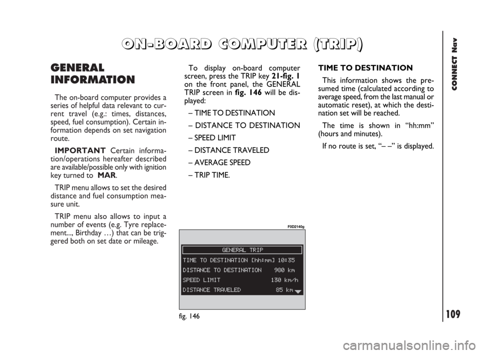
fig. 146
F0D2140g
To display on-board computer
screen, press the TRIP key 21-fig. 1
on the front panel, the GENERAL
TRIP screen in fig. 146will be dis-
played:
– TIME TO DESTINATION
– DISTANCE TO DESTINATION
– SPEED LIMIT
– DISTANCE TRAVELED
– AVERAGE SPEED
– TRIP TIME.
Page 112 of 246
CONNECT Nav
111
TRIP SUBMENU
To display the trip computer sub-
menu, press “TRIP” key 21-fig. 1and
when the above described list of in-
formation is displayed press the knob
22-fig. 1. The following menu will be
displayed fig. 147:
– GENERAL TRIP
– SETUP
– SPEED
To select the required menu, rotate
the knob 22-fig. 1and then press it to
confirm.GENERAL TRIP
Selecting “GENERAL TRIP” with the
knob 22-fig. 1and pressing it to con-
firm will display the following menu:
– TIME TO DESTINATION
– DISTANCE TO DESTINATION
– SPEED LIMIT
– DISTANCE TRAVELED
– AVERAGE SPEED
– TRIP TIME.TRIP: SETUP
This function enables to change the
units of measure relevant to distance,
speed and fuel consumption.
Selecting SETUP with the knob 22-
fig. 1and pressing it to confirm will
display the following menu fig. 148:
– INFO
– DISTANCE UNITS
– OK.
fig. 147
F0D2141g
fig. 148
F0D2177g
Page 199 of 246

CONNECT Nav+
198
GENERAL
INFORMATION
The navigator integrated in the
CONNECT Nav+ allows you to reach
the chosen destination by visual and
voice instructions. Use of the naviga-
tion system is quick, convenient, safe
and above all very flexible because it al-
lows you to call up already pro-
grammed destinations or points of ref-
erence such as hotels, monuments,
public structures, fuel stations or Fi-
at Dealerships.
The vehicle position is determined
through the GPS system (Global Posi-
tioning System) installed on the vehicle.
The GPS system is fitted with an an-
tenna and a reception module inte-
grated in the telematic system. This sys-
tem configuration dynamically process-
es the satellite signals, those from the
right and left odometer, the reversing
signal and the information of the gyro-
scope integrated in the navigation com-
puter, integrating them with the cur-
rent position of the vehicle to obtain an
“estimated vehicle point”.The signals from the right and left
odometer make it possible to deter-
mine the movement of the vehicle, the
gyroscope signal identifies any turn-
ing and the reversing sensor distin-
guishes the direction of travel.
The Fiat navigation system helps the
driver while he/ahe drives by suggest-
ing vocally and graphically the opti-
mum routing to reach the preset des-
tination.IMPORTANT NOTES
– GPS reception is difficult under
trees, among tall buildings, in multi-lev-
el car parks, tunnels and everywhere
reception of the satellite antenna may
be hindered.
– The GPS system needs about 15
minutes for activation if the vehicle
battery is disconnected.
– The GPS system needs a few min-
utes to determine the new position of
the vehicle if it is turned off and the ve-
hicle is moved with the system off (e.g.:
by breakdown van).
– In the lack of satellite information,
the system uses information from the
gyroscope and from the special sen-
sors for temporary data analysis.
– The GPS satellite aerial must not
be covered with metal or damp ob-
jects.
N N
A A
V V
I I
G G
A A
T T
O O
R R
( (
N N
A A
V V
) )
The navigation system sug-
gestions do not exempt the
driver from full responsibility due to
his driving behaviour and to com-
pliance with road and other traffic
regulations. The responsibility for
road safety always and in any case
lies with the vehicle driver.
WARNING