2020 MERCEDES-BENZ S-CLASS COUPE ECU
[x] Cancel search: ECUPage 291 of 542
R
Incom pletedigit almap data
No teson GPS recep tion
The correct functi onofthena vig ation system
depends amongstot her things onGPS recep‐
tion. Incer tain situat ionsGPS recep tion canbe
im paired, defectiv eor eve nno tpo ssi ble, e.g .in
tunne lsor inpa rking garage s.
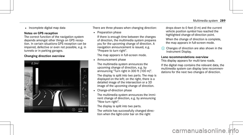
Changing direction overview Ther
ear eth re ephases whenchang ingdirect ion:
R Preparation phase
If th er eis enough timebetween thech ang es
of dir ect ion,th emultimedia system prepar es
yo ufo rth eupcoming chang eof dir ect ion.A
na vig atio nann oun cem entisissue d,e.g .
"Pr epar eto tur nright".
The map appear sin full-scr eenmode.
R Ann ouncemen tphase
The multimedia system announ cesthe
upco mingch ang eof dir ect ion,e.g .by
ann oun cing"T ur nright in300 ft(100 m)".
The displa yis split intotw opar ts.The map is
displa yedon thelef t;on theright, ther eis a
de tailed imag eof theint ersect ionora3D
imag eof theupcoming chang eof dir ect ion.
R Chan ge-of-d irecti onpha se
The multimed iasystem announ cestheimmi‐
nen tch ang eof dir ect ion,e.g .by ann oun cing
"No wtur nright".
The displa yis split intotw opar ts.
The vehicle hassuccessfull ych ang eddirec‐
tio nwhen thelight- color barontheright dr
ops down to0feet (0 m) and thecur rent
ve hicle position symbolhasreac hed the
highlight edchang e-of-dir ect ion poin t.
When thech ang eof dir ect ion iscom plete,
th emap appear sin full-scr eenmode.
% Chang esofdir ect ion arealso showninthe
Ins trument Display.
Lane recomm endationsov ervie w
This displa yappear sfo rmulti -lane roads.
If th edigit almap contains there leva nt data,th e
multime diasystem can displa ylane recomme n‐
da tions forth ene xt twoch ang esofdir ect ion. Mult
imed iasystem 289
Page 294 of 542
Ov
ervie wof routeguidanc eto an off-r oad
des tinatio n
An off-r oad destinatio nis wit hin thedigit almap.
The map contains noroads that lead tothedes‐
tinat ion.
Yo ucan enterge o-coor dinatesorath re ewo rd
addr essforof f-r oad destinations onthemap.
Ro uteguidan ceguides youfo ras long aspossi ‐
ble withna vig ation announcements anddisplays
on roads that arekn ow nto themultimedia sys‐
te m.
Shor tlybef oreyo ure ac hth elas tkn ow npo sitio n
on themap, youwill hear the"Please follo wthe
dir ect ion arrow "ann oun cem ent.The displ ay
sho wsadir ect ion arrow and thelinear distance
to thedes tinat ion.
Ov ervie wof routeguidanc efrom anoff-r oad
loc ation toades tinatio n
Of f-road position: thecur rent vehicle position is
locat edwithin thedigit almap onroads that are
no tav ailable.
When routeguidan cebegin sth efo llo wing dis‐
pla ysappear :
R The Road NotMapped messageis sho wn. R
Adir ect ion arro w sho wing thelinear direc‐
tion tothePOI.
When theve hicle isbac kon aro ad know nto the
multime diasystem, routeguidan cecontinue sas
no rm al.
Ov ervie wof off-ro ad status during route
guidanc e
Due toroadw orks ,fo rex am ple, ther ema ybe dif‐
fe re nces betwee nth edat aon thedigit almap
and theactual courseofthero ad. Insuc hcas es,
th emultimedia system will temp orarily be
unable tolocat eth eve hicle's current positio non
th edigit almap. Thevehicle isoff-r oad.
When theve hicle isoff-r oad, thefo llo wing dis‐
pla ysaresho wn:
R theRoad NotMapped message
R adir ect ion arrow showing thelinear direct ion
to thePOI
When theve hicle isbac kon aro ad know nto the
multime diasystem, routeguidan cecontinue sas
no rm al. Des
tination Sa
ving thecur rent vehicl eposi tion
Mul timedi asy stem:
4 Navigation #
Ifth emap isdispla yedin full screen mode,
pr ess thecent ralcon trol elemen t.
The map menuappear s. #
Selec t1 onthemap menu (/page296).
The current vehicle position issave dto the
"Pr evious destination s"memo ry.
St oring ama pposit ion
Mult imedia system:
4 Navigation
The map isin full-scr eenmode. #
Press theTo uc hCon trol, thecon troller orthe
to uc hpad. #
Select "mo vemap" inmap menu 2
(/ page296) . #
Select aposi tion onthemap.
If multiple entries areav ailable fora map
posi tion, alis tapp ears. #
Highl ightanentr y. 292
Multimedia system
Page 297 of 542
-
Roadw orks
- Road bloc ks
- Warning mess ages
The symbols fortr af fic inci dents aredis‐
pl ay ed incolor (onthero ute) or gra y(of fth e
ro ute).
R Traf fic flow informatio n:
- Traf fic jam (red line)
- Slow-mo ving traf fic (or ang eline)
- Hea vytraf fic (yel lo w line)
- Free-f lowing traffic (gr een line)
R Disp lay fo rtr af fic del ayson thero utelas ting
at leas ton emin ute
R Warning mess agesymbols:
- Symbo lÔ
- Addition alroad safetyno teswhen
appr oaching atraf fic inci dent, e.g.the
end ofatra ffic jam
If th eve hicle approaches adang erarea
on thero ute, awa rning mess ageis dis‐ pla
yedon themap. Awa rning mess age
ma yalso beissued (/page296) .
Displa yingtraf fic incid ents
Mult imed iasystem:
4 Navigation 5
Z Option s
5 Map Conten t #
Activate0073 TrafficInci dents .
Ro adw orks ,ro ad bloc ks,local area repor ts
(e.g. fog) and warning mess ages aredis‐
pla yed.
Ac tiv atin gfree flowan dtraf fic dis pla y #
Activate0073 FreeFlo wing Tra fficand Traffic
Del ays.
% Thetraf fic del ayisdispla yedfo rth ecur rent
ro ute. Traf fic del ayslas ting oneminut eor
long erareta ke nint oconsi deratio n.
Di spl aying details #
Displa ysthetraf fic map (/page 294). #
Movesth emap (/page29 7). #
When atra ffic repor tsymbol isunder the
cr oss hair,pr ess onthecent ralcon trol ele‐
men t.
The traffic re por tde tails aredispla yed.
or #
Press onthecent ralcon trol elemen t. #
Selec tInf ormat iononTraff icReport s.
The map showsthetraf fic re por tsymbols in
th evicinit y.
Tr af fic re por tinf ormation isdispla yedin the
st atus line:
R Traf fic re por tsymbol
R Reason forth etraf fic re por t,e.g. traffic
con gestion
R Warning mess age(highligh tedin red) #
Toselect atraf fic re por tsymb ol:sel ect
Next orPre vious. #
Press onthecent ralcon trol elemen t.
The traffic re por tde tails aredispla yed. Multimedia
system 295
Page 298 of 542
Issu
inghazard wa rnings
Multime diasystem:
4 Navigation 5
Z Option s
5 Announc ement s #
Activate0073 Annou nceTrafficWa rnings .
Wa rning mess ages areissued andtailbac ks
whic hpose arisk areannounced. Map
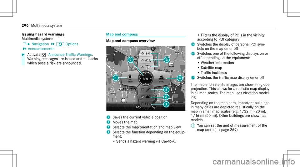
andcom pass Map
andcom pass overview 1
Savesth ecur rent vehicle position
2 Movesth emap
3 Select sth emap orient ation andmap view
4 Select sth efunc tion depending ontheeq uip‐
ment :
• Sends ahazar dwa rning viaCar -to-X . •
Filt ersth edispla yof POIs inthevicin ity
accor dingtoPOI categor y
5 Switc hesthedispla yof per sonal POIsym‐
bols onthemap onoroff
6 Switc hesone ofthefo llo wing displa yson or
of fdepending ontheeq uipment :
• We ather informat ion
• Sat ellit emap
• Traf fic inci dents
7 Switches thetra ffic map displa yon oroff
The map andsatellit eimag esaresho wninglobe
pr oject ion.This allowsfora re alis ticmap displa y
in all map scales. Themap uses elevatio nmod el‐
ing .
Dep endingonthemap data,im por tant buildi ngs
in ma nyciti esaredep icted realis ticallyon the
map insmal lmap scale s(e.g. 1/32 mi(20 m),
1/1 6mi (50 m)). Other buildings aresho wnas
model s.
% Youcan setth eunit ofmeasur ementofthe
map scale (/page269) . 296
Multimedi asy stem
Page 300 of 542
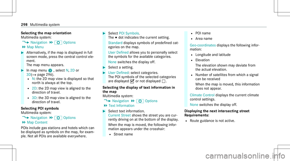
Selec
tingthema por ientat ion
Multi media system:
4 Navigation 5
Z Option s
5 Map Menu #
Alternativ ely,if th emap isdispla yedin full
scr een mode, press thecent ralcon trol ele‐
men t.
The map menuappear s. #
Inmap menu3 ,selec tN, 2D or
3D( /pag e296 ).
R N:the2D map viewisdispla yedso that
no rth is alw aysat theto p.
R 2D: the2D map viewisaligned tothe
dir ect ion oftrav el.
R 3D: the3D map viewisaligned tothe
dir ect ion oftrav el.
Selecting POIsymbols
Multimedia system:
4 Navigation 5
Z Option s
5 Map Conten t
POIs include gasst atio nsand hotels whic hcan
be displa yedas symbols onthemap, forex am‐
ple. Notall POI sar eav ailable everywher e. #
Sele ctPOI Symb ols.
The 003Bdo tindic ates thecur rent setting.
Stand arddispl ayssymbols ofpredef ined cat‐
egor iesonthemap.
User Definedallo wsyouto per sonall yselect
th esymbols forth eav ailable categor ies.
Non eswit ches thedispla yof f. #
Select ase tting. #
User Defined:select categor ies.
The POIsymbols oftheselect edcat egor ies
ar edispla yed0073 ornotdispla yed0053.
Selecting thedisp layof text inf ormat ionin
th ema p
Multi media system:
4 Navigation 5
Z Option s
5 Text Information #
Select text informati on.
Cu rrent Streetsho wsthest re et youar ecur ‐
re ntly drivi ng on atthebo ttom ofthedispla y.
When themap ismo ved, thefo llo wing infor‐
matio nappear sunder thecr osshair :
R Street nam e R
POI nam e
R Area nam e
Ge o-co ordinates displ aysth efo llo wing infor‐
matio n:
R Lon gitude andlatitude
R Elevatio n
Th eelev atio nsho wnmayde viat efrom
th eactual elevatio n.
R Number ofsat ellites from whic hasignal
can berecei ved
When themap ismo ved, this inf ormatio n
does notappear .
Climate Controldispla ysthecur rent clima te
contr olsettings.
None switches thedispla yof f.
Displa yingthene xt int ersectin gst re et
Re quirement s:
R Routeguidan ceisno tact ive. 298
Multimed iasystem
Page 303 of 542
Fo
rmap datath at youha ve pur chased inthe
fo rm ofadat ast or ag emedium, youmus ten ter
th eaccom panying activ ation code.
% Ifyo usa ve themap dataon adat ast or ag e
medium withth eonline mapupdat eser vice,
no ent ryisrequ ired. The activation codeis
st or ed on thedat ast or ag emedium during
th edo wnloading process.
Obser vethefo llo wing when entering theactiv a‐
tion code:
R The activ ation codecanbeused forone vehi‐
cle
R The activ ation codeisno ttr ansf erable
R The activ ation codehassixdigits
In theeve ntofthefo llo wing problems ,please
con tact an author ized Mercedes-B enzCent er:
R The multimedia system does notaccep tth e
act ivatio ncod e
R Youha ve lostth eactiv ation code Displa
yingthecom pass
Multi media system:
4 Navigation 5
À Route andPosition #
Select Compass.
The com pass displa ysho wsthefo llo wing
inf ormatio n:
R thecur rent dire ction oftrave lwit hbear‐
ing (360 °fo rm at) and compass direct ion
R longitude andlatitude coordinat esin
degr ees, minutes and seco nds
R height (rounded )
R numb erofGPS satellit esfrom whic ha
sign alcan berecei ved
Se tting thema pscale automa tically
Multi media system:
4 Navigation 5
Z Option s
The map scale issetaut omaticall ydepending on
yo ur drivin gspee d.
Fo rjour neys incit ies withde tailed citymodels ,a
map viewfrom thedr iver's perspect ive is used. #
Switc hAuto Zoom on0073 oroff0053. %
The automaticall yselect edmap scale canbe
ch ang edman uallyfo ra shor ttime. Theset‐
ting isrese taut omatically afte ra fe w sec ‐
ond s.
Displa yingthesat ellit ema p
Multi media system:
4 Navigation 5
Z Option s
5 Map Conten t #
Switc hSatellit eMap on0073 oroff0053.
or #
Ifsat ellit emap displa y6 isavailable inthe
map menu, switchit on 0073 oroff0053
(/ page296) .
Switc hedon0073: satellite maps aredisp laye d
in map scales of2mi (2km )or less.
Swit ched off0053: satellit emaps areno tdis‐
pla yedin map scales from 2mi (2km) to
10 mi(10 km).
% Satellite maps forth ese map scales areno t
av ailable inall coun tries.
Displ aying weather information
Re quirement s: Multime
diasystem 30
1
Page 304 of 542
R
Mer cedes meconn ectisavailable.
R Youha ve auser accoun tfo rth eMer cedes
me portal.
R The service isavailable.
R The servicehas been activat ed atan aut hor ‐
ize dMer cedes-Ben zCent er.
Fu rther information canbefound at:ht tp :/ /
www .merced es.me
Mult imed iasystem:
4 Navigation 5
Z Option s
5 Map Conten t #
ActivateWe ath erInfo rma tion0073.
or #
Ifwe ather informat iondispla y6 isavailable
in themap menu, activate0073(/ page296)
it.
Cur rent we ather informat ionisdispla yedon
th ena vig ation map,e.g.temp eratur eor
cloud cover.
% Weather informat ionisno tav ailable inall
coun tries. Calli
ngup theDigital Operator' sMan ual
(na vigation) Calling
upinforma tion onnavig ation
Multi media system:
4 Navigation 5
Z Option s
5 Navigation Info #
Select theto pic. Te
lephone Te
lephon y No
teson telephon y &
WARNIN GRisk ofdist ra ction from oper‐
ati ng integr ated commu nication equip‐
ment whiletheve hicle isin mo tion
If yo uoper ateco mm unic ationeq uipme nt
int egrat edintheve hicle when driving, you
will bedistract edfrom thetra ffic situat ion.
This could alsocause youto lose control of
th eve hicle. #
Onlyoper ateth is eq uipmen twhen the
tr af fic situ ation per mits. #
Ifyo ucan notbe sur eof this, stop the
ve hicle whilstpa ying attention toroad
and traffic condi tions andoperate the
eq uipment withth eve hicle statio nary. &
WARNIN GRisk ofan acci dent from
ope rating mob ile comm unicati onequip ‐
ment while th eve hicle isin mo tion
Mobile communication sde vices distract the
dr iver from thetraf fic situ ation. Thiscou ld
al so cau sethedr iver tolose control of the
ve hicle. #
Asthedr iver ,onl yoper atemobile com‐
municat ionsdevices when theve hicle is
st atio nary. #
Asave hicle occupant, onlyuse mobile
communication sde vices inthear eas
int ended forth is pur pose, e.g.inthe
re ar passe nger com partment . Yo
umus tobse rveth eleg alrequ iremen tsforth e
cou ntryin whi chyouar ecur rentl ydr ivi ng when 30
2
Mu ltimed iasystem
Page 305 of 542
oper
ating mobile communic ationequipment in
th eve hicle.
Fu rther information canbeobt ained from an
aut hor ized Mercedes-Ben zCent eror at:
https: //www .mercedes-benz -mobile.com/
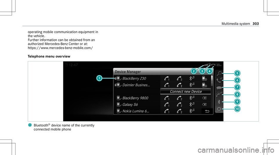
Te lephone menuoverview 1
Blue tooth®
de vice name ofthecur rently
conne cted mob ile pho ne Mu
ltimed iasystem 303