Page 81 of 92
81
1
2
3
4
5
6
4.2.3 Traffic Settings
ButtonDescription
Use this switch to enable or disable historical
traffic data and traffic patterns. This locally
stored information can be very useful in normal
circumstances but for example on public
holidays it may be better to turn off in order
not to take into account normal weekday traffic
jams.
Alternative routes are offered for detours.
An appropriate alternative route is determined
provided by the navigation system in
consideration of traffic conditions.
You can select how much time delay on the
alternative route you are willing to accept.
The alternative route is offered based on the set
time.
Some functions are not available depending on some countries and regions.
NAV-999VU1EH.indb 812017/12/06 13:18:36
Page 82 of 92
 82
4.2.4 Route
Settings
These settings determine how routes will be calculated.
Button
Description
The route calculation can be optimized for
different situations. See below for details.
You migh")
82
4.2.4 Route
Settings
These settings determine how routes will be calculated.
Button
Description
The route calculation can be optimized for
different situations. See below for details.
You might need to avoid highways/freeways if
you are towing another vehicle.
Charge roads are pay roads where you can
purchase a pass or vignette to use the road for
a longer period of time. They can be enabled or
disabled separately from toll roads.
The navigation system includes toll roads (pay
roads where there is a per-use charge) in the
routes by default. If you disable toll roads, the
navigation system plans the best toll-free route.
The navigation system includes ferries in a
planned route by default. However, a map does
not necessarily contain information about the
accessibility of temporary ferries. You might
also need to pay a fare on ferries.
Setting in which routes with carpool lanes can
be created or not created.
A border crossing may be a shorter route
depending on the route. For this function, you
can select whether or not to cross a border when
planning the route.
The navigation system excludes unpaved roads
by default: unpaved roads can be in a bad
condition and usually you cannot reach the
speed limit on them.
Some functions are not available depending on some countries and regions.
NAV-999VU1EH.indb 822017/12/06 13:18:36
Page 83 of 92
 83
1
2
3
4
5
6
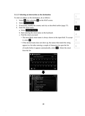
4.2.5 Map Settings
You can fine-tune the appearance of the Map screen, adjust the map view to your
needs, show or suppress 3D buildings, and manage Place visibility settings (which")
83
1
2
3
4
5
6
4.2.5 Map Settings
You can fine-tune the appearance of the Map screen, adjust the map view to your
needs, show or suppress 3D buildings, and manage Place visibility settings (which
Places to show on the map).
The map is always shown on the screen so that you can see the effect when you
change a setting. Scroll the screen downward to display the setting behind the lower
part of the screen.
Button Description
When this button is selected, the map view mode can
be changed.
•
: Displays things such as actual construction
sites three dimensionally on the map.
•
: The map is rotated so that the direction of
travel is displayed in the upward direction.
•
: The map is displayed so that north is up
regardless of the direction of travel.
Adjust the basic zoom and tilt levels to your needs.
Three levels are available.
During route guidance in any map view mode, the
function for zooming in on approaching intersections
turns on/off automatically.
Show or hide 3D city models, 3D artistic or block
representation of all city building data containing
actual building sizes and positions on the map.
NAV-999VU1EH.indb 832017/12/06 13:18:36
Page 84 of 92
84
ButtonDescription
When enabled, the map zooms out to show an
overview of the surrounding area if the next route
event (maneuver) is far away. The system goes back
to the normal map view when you approach the next
event.
Select which Places to show on the map while
navigating. Too many Places make the map crowded,
so it is a good idea to show as few as possible. You
have the following possibilities:
•
Select the checkbox to show or hide the Place
category.
•
Select the name of the Place category to open the list
of its subcategories.
NAV-999VU1EH.indb 842017/12/06 13:18:36
Page 85 of 92
85
1
2
3
4
5
6
4.2.6 Visual Guidance settings
Adjust how the software helps you navigate with different kinds of route related
information on the Map screen.
ButtonDescription
Whenever adequate information is available, lane
information similar to the real ones on road signs
above the road is displayed at the top of the map.
You can turn this feature on or off.
If you are approaching a highway/freeway exit or
a complex intersection and the needed information
exists, the map is replaced with a 3D view of the
junction. You can turn this feature on or let the map
be displayed for the whole route.
When entering tunnels, the surface roads and
buildings can be disturbing. This feature shows a
generic picture of a tunnel instead of the map. A top-
down overview of the tunnel and remaining distance
are also displayed.
NAV-999VU1EH.indb 852017/12/06 13:18:36
Page 86 of 92
 86
5 Glossary
Active route
The currently navigated route. Whenever a destination is set, the route is active until
you delete it or reach your destination. See also: Route.
City
Center
The city ce")
86
5 Glossary
Active route
The currently navigated route. Whenever a destination is set, the route is active until
you delete it or reach your destination. See also: Route.
City
Center
The city center is not the geometric center of the city but an arbitrary point the
map creators have chosen. In cities and villages, it is usually the most important
intersection; in larger cities, it is one of the important intersections.
Color
theme
The navigation system has different color themes for daytime and nighttime which
can be selected as desired.
One daytime scheme and one nighttime scheme is always selected for the map and
for the menus.
The navigation system uses them when it switches from day to night and back.
GPS
accuracy
Several factors have impact on the deviation between your real position and the one
given by the GPS device. For example, signal delay in the ionosphere or reflecting
objects near the GPS device have a different and varying impact on how accurately
the GPS device can calculate your position.
NAV-999VU1EH.indb 862017/12/06 13:18:36
Page 87 of 92
 87
1
2
3
4
5
6
5 Glossary
Active route
The currently navigated route. Whenever a destination is set, the route is active until
you delete it or reach your destination. See also: Route.
City Center")
87
1
2
3
4
5
6
5 Glossary
Active route
The currently navigated route. Whenever a destination is set, the route is active until
you delete it or reach your destination. See also: Route.
City Center
The city center is not the geometric center of the city but an arbitrary point the
map creators have chosen. In cities and villages, it is usually the most important
intersection; in larger cities, it is one of the important intersections.
Color theme
The navigation system has different color themes for daytime and nighttime which
can be selected as desired.
One daytime scheme and one nighttime scheme is always selected for the map and
for the menus.
The navigation system uses them when it switches from day to night and back.
GPS accuracy
Several factors have impact on the deviation between your real position and the one
given by the GPS device. For example, signal delay in the ionosphere or reflecting
objects near the GPS device have a different and varying impact on how accurately
the GPS device can calculate your position.
Map
The navigation system works with digital maps which are not simply the
computerized versions of traditional paper maps. Similarly to paper road maps, the
2D mode of digital maps show you streets, roads, and elevation by colors.
In 3D mode, you can see the altitude differences, for example valleys and
mountains, elevated roads, and in selected cities 3D landmarks and 3D buildings are
also displayed.
You can use digital maps interactively: you can zoom in and out (increase or
decrease the scale), you can tilt them up and down, and rotate them left and right. In
GPS-supported navigation, digital maps facilitate route planning.
North-up
map orientation
In North-up mode the map is rotated so its top always faces North. This is the
orientation for example in Find on Map.
Road
Safety Camera
This function is not available in some countries and regions.
Special alert points for speed, red light or bus lane cameras. Dif ferent data sources
are available. You can configure the navigation system to warn you when you
approach one of these cameras.
Detecting the location of Road Safety Cameras is prohibited in certain countries.
It is the sole responsibility of the driver to check whether this feature can be used
during the trip.
The software is capable of showing and warning for more than just cameras. V
arious
other types of proximity alert points like school zones and railway crossings are also
available.
Route
A sequence of maneuvers (for example, turns and roundabouts) to reach the
destination. The route contains one start point and one or more destinations.
T
rack-up
map orientation
In Track-up mode the map is rotated so its top always points in the current driving
direction.
This is the default orientation in 3D map view mode.
Vehicle
marker
The current position is indicated by a blue arrow on the map. The direction the blue
arrow is pointed indicates the current heading.
NAV-999VU1EH.indb 872017/12/06 13:18:36
Page 88 of 92
 88
6 End-User Terms
The data is provided for your personal, internal use only and not for resale. It is
protected by copyright, and is subject to the following terms and conditions which
are agree")
88
6 End-User Terms
The data is provided for your personal, internal use only and not for resale. It is
protected by copyright, and is subject to the following terms and conditions which
are agreed to by you, on the one hand, and VISTEON and its licensors (including
their licensors and suppliers) on the other hand.
© 2013HERE. All rights reserved.
The Data for areas of Canada includes information taken with permission from
Canadian authorities, including: © Her Majesty the Queen in Right of Canada, ©
Queen’s Printer for Ontario, © Canada Post Corporation, GeoBase
®, © Department
of Natural Resources Canada.
HERE holds a non-exclusive license from the United States Postal Service
® to
publish and sell ZIP+4® information.
©United States Postal Service
® 2013. Prices are not established, controlled or
approved by the United States Postal Service®. The following trademarks and
registrations are owned by the USPS: United States Postal Service, USPS, and
ZIP+4.
The Data for Mexico includes certain data from Instituto Nacional de Estadística y
Geografía.
Terms
and Conditions
Personal Use Only: Y
ou agree to use this Data together with VISTEON’s CMU for
the solely personal, non-commercial purposes for which you were licensed, and not
for service bureau, time-sharing or other similar purposes. Accordingly, but subject
to the restrictions set forth in the following paragraphs, you agree not to otherwise
reproduce, copy, modify, decompile, disassemble, create any derivative works of, or
reverse engineer any portion of this Data, and may not transfer or distribute it in any
form, for any purpose, except to the extent permitted by mandatory laws.
NAV-999VU1EH.indb 882017/12/06 13:18:36


 81
1
2
3
4
5
6
4.2.3 Traffic Settings
ButtonDescription
Use this switch to enable or disable historical
traffic data and traffic patterns. This locally
stored information can be very useful in nor")
 84
ButtonDescription
When enabled, the map zooms out to show an
overview of the surrounding area if the next route
event (maneuver) is far away. The system goes back
to the normal map view when you")
 85
1
2
3
4
5
6
4.2.6 Visual Guidance settings
Adjust how the software helps you navigate with different kinds of route related
information on the Map screen.
ButtonDescription
Whenever adequate in")