Page 101 of 243

may adversely affect the operation of
the pacemaker while using the Nis-
sanConnect
SMServices.
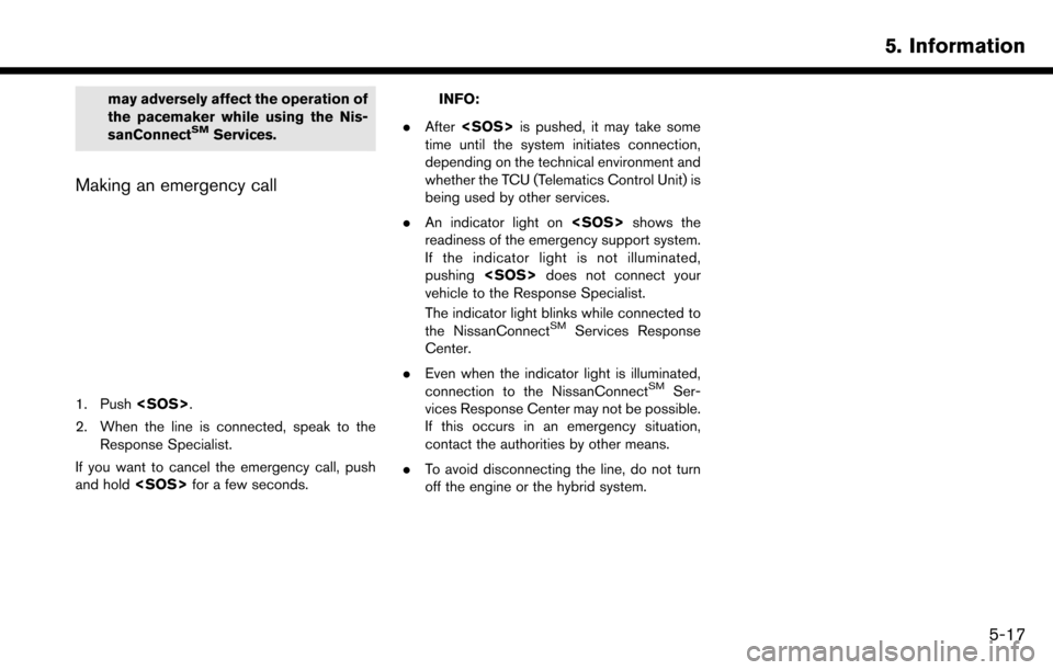
Making an emergency call
1. Push.
2. When the line is connected, speak to the Response Specialist.
If you want to cancel the emergency call, push
and hold for a few seconds.
INFO:
. After is pushed, it may take some
time until the system initiates connection,
depending on the technical environment and
whether the TCU (Telematics Control Unit) is
being used by other services.
. An indicator light on shows the
readiness of the emergency support system.
If the indicator light is not illuminated,
pushing does not connect your
vehicle to the Response Specialist.
The indicator light blinks while connected to
the NissanConnect
SMServices Response
Center.
. Even when the indicator light is illuminated,
connection to the NissanConnect
SMSer-
vices Response Center may not be possible.
If this occurs in an emergency situation,
contact the authorities by other means.
. To avoid disconnecting the line, do not turn
off the engine or the hybrid system.
5. Information
5-17
Page 113 of 243

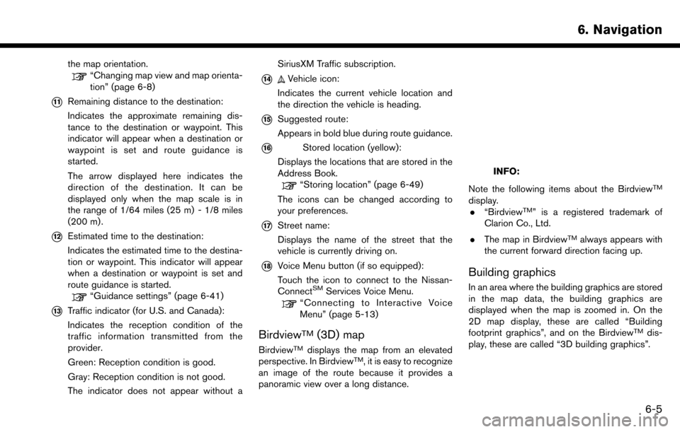
the map orientation.“Changing map view and map orienta-
tion” (page 6-8)
*11Remaining distance to the destination:
Indicates the approximate remaining dis-
tance to the destination or waypoint. This
indicator will appear when a destination or
waypoint is set and route guidance is
started.
The arrow displayed here indicates the
direction of the destination. It can be
displayed only when the map scale is in
the range of 1/64 miles (25 m) - 1/8 miles
(200 m) .
*12Estimated time to the destination:
Indicates the estimated time to the destina-
tion or waypoint. This indicator will appear
when a destination or waypoint is set and
route guidance is started.
“Guidance settings” (page 6-41)
*13Traffic indicator (for U.S. and Canada):
Indicates the reception condition of the
traffic information transmitted from the
provider.
Green: Reception condition is good.
Gray: Reception condition is not good.
The indicator does not appear without aSiriusXM Traffic subscription.
*14Vehicle icon:
Indicates the current vehicle location and
the direction the vehicle is heading.
*15Suggested route:
Appears in bold blue during route guidance.
*16Stored location (yellow):
Displays the locations that are stored in the
Address Book.
“Storing location” (page 6-49)
The icons can be changed according to
your preferences.
*17Street name:
Displays the name of the street that the
vehicle is currently driving on.
*18Voice Menu button (if so equipped):
Touch the icon to connect to the Nissan-
Connect
SMServices Voice Menu.“Connecting to Interactive Voice
Menu” (page 5-13)
BirdviewTM(3D) map
BirdviewTMdisplays the map from an elevated
perspective. In BirdviewTM, it is easy to recognize
an image of the route because it provides a
panoramic view over a long distance.
INFO:
Note the following items about the Birdview
TM
display. . “BirdviewTM” is a registered trademark of
Clarion Co., Ltd.
. The map in Birdview
TMalways appears with
the current forward direction facing up.
Building graphics
In an area where the building graphics are stored
in the map data, the building graphics are
displayed when the map is zoomed in. On the
2D map display, these are called “Building
footprint graphics”, and on the Birdview
TMdis-
play, these are called “3D building graphics”.
6. Navigation
6-5
Page 155 of 243

4. Touch a preferred events from the list tocheck the detailed information and the map.
Displaying urgent traffic information
When an urgent event is found around the
current vehicle location, a message pops up
automatically on the touch screen display with a
voice announcement.
The message includes the icon, event type, event
information and the direct distance from the
current location to the event.
INFO:
. Urgent traffic information is displayed re-
gardless of whether [Use Traffic Info] func-
tion is on or off.
“Traffic information setting”
(page 6-48)
. When there are multiple urgent events, the
event with the shortest direct distance from
the current location is displayed.
. If the urgent event is on the recommended
route, and if a detour is found, the detour
route notification screen is displayed when
the vehicle approaches the detour point.
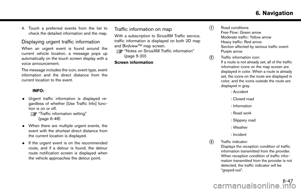
Traffic information on map
With a subscription to SiriusXM Traffic service,
traffic information is displayed on both 2D map
and Birdview
TMmap screen.“Notes on SiriusXM Traffic information”
(page 5-20)
Screen information
*1Road conditions
Free Flow: Green arrow
Moderate traffic: Yellow arrow
Heavy traffic: Red arrow
Section affected by serious traffic event:
Purple arrow
*2Traffic information icon:
If a route is not already set, all of the traffic
information icons on the map screen are
displayed in color. When a route is already
set, the icons on the route are displayed in
color, and the icons outside the route are
displayed in gray.
: Accident
: Closed road
: Information
: Road work
: Slippery road
: Weather
: Incident
*3Traffic indicator:
Displays the reception condition of traffic
information transmitted from the provider.
When reception condition of traffic infor-
mation transmitted from the provider is not
detected, the traffic indicator will be
“grayed-out”.
6. Navigation
6-47