2016 HONDA ACCORD SEDAN Navigation Manual (in English)
-
 1
1 -
 2
2 -
 3
3 -
 4
4 -
 5
5 -
 6
6 -
 7
7 -
 8
8 -
 9
9 -
 10
10 -
 11
11 -
 12
12 -
 13
13 -
 14
14 -
 15
15 -
 16
16 -
 17
17 -
 18
18 -
 19
19 -
 20
20 -
 21
21 -
 22
22 -
 23
23 -
 24
24 -
 25
25 -
 26
26 -
 27
27 -
 28
28 -
 29
29 -
 30
30 -
 31
31 -
 32
32 -
 33
33 -
 34
34 -
 35
35 -
 36
36 -
 37
37 -
 38
38 -
 39
39 -
 40
40 -
 41
41 -
 42
42 -
 43
43 -
 44
44 -
 45
45 -
 46
46 -
 47
47 -
 48
48 -
 49
49 -
 50
50 -
 51
51 -
 52
52 -
 53
53 -
 54
54 -
 55
55 -
 56
56 -
 57
57 -
 58
58 -
 59
59 -
 60
60 -
 61
61 -
 62
62 -
 63
63 -
 64
64 -
 65
65 -
 66
66 -
 67
67 -
 68
68 -
 69
69 -
 70
70 -
 71
71 -
 72
72 -
 73
73 -
 74
74 -
 75
75 -
 76
76 -
 77
77 -
 78
78 -
 79
79 -
 80
80 -
 81
81 -
 82
82 -
 83
83 -
 84
84 -
 85
85 -
 86
86 -
 87
87 -
 88
88 -
 89
89 -
 90
90 -
 91
91 -
 92
92 -
 93
93 -
 94
94 -
 95
95 -
 96
96 -
 97
97 -
 98
98 -
 99
99 -
 100
100 -
 101
101 -
 102
102 -
 103
103 -
 104
104 -
 105
105 -
 106
106 -
 107
107 -
 108
108 -
 109
109 -
 110
110 -
 111
111 -
 112
112 -
 113
113 -
 114
114 -
 115
115 -
 116
116 -
 117
117 -
 118
118 -
 119
119 -
 120
120 -
 121
121 -
 122
122 -
 123
123 -
 124
124 -
 125
125 -
 126
126 -
 127
127 -
 128
128 -
 129
129 -
 130
130 -
 131
131 -
 132
132 -
 133
133 -
 134
134 -
 135
135 -
 136
136 -
 137
137 -
 138
138 -
 139
139 -
 140
140 -
 141
141 -
 142
142 -
 143
143 -
 144
144
 72
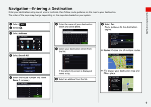
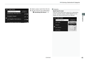
Navigation
Calculating the Route
This section describes how to calculate your route.
Select Go!.
uThe system calculates and displays
the route line on the map screen.
The following options are ava")
 73
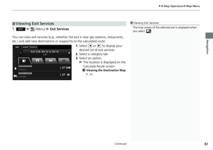
uu Calculating the Route u Viewing and Selecting the Routes
Navigation
Viewing and Selecting the Routes
View and select different routes to your destination.
1.Select or to change a route.
uThe t")
 74
uu Calculating the Route u Viewing the Destination Map
Navigation
Viewing the Destination Map
1.Select an option.
2.Select Go!.
uThe system calculates and
displays the route line on the
map scree")
 75Continued
Navigation
Driving to Your Destination
Viewing the Route
This section describes how to follow the route guidance to your destination.
After calculating the route to your
destination, the")
 uu Driving to Your Destination u Viewing the Route
76
Navigation
• Select the map dashboards when you want to change the information that is
displayed. Select the following options:
Arrival Time, D")
 Continued77
uu Driving to Your Destination u Viewing the Route
Navigation
The turn information screen displays the turn on the map and the distance and time
remaining before you reach the turn. The l")
 uu Driving to Your Destination u Viewing the Route
78
Navigation
If you leave the calculated route, the system automatically recalculates a route to the
set destination based on your current location")
 79
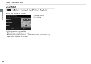
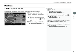
Navigation
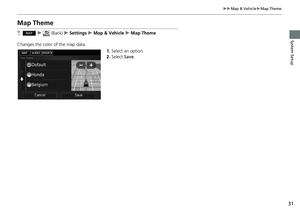
Map Operation
Customize the map, set a destination, and save a place from the map.
1.Select any point on the map.
2.Select an option.
uIf you want to set a destination
or save a locatio")