Page 81 of 129
 -
Information on the displayMenu screen
To access the Navigation menu
screen, press 7 followed by ýNav .
The Navigation menu screen
contains the following m")
Navigation81NAVI 50 IntelliLink (Type B) -
Information on the displayMenu screen
To access the Navigation menu
screen, press 7 followed by ýNav .
The Navigation menu screen
contains the following menus and
submenus:
● Destination
Refer to (NAVI 50 IntelliLink)
"Destination input" 3 90.
● Address
● Points of interest
● History
● Favourites
●Find on map
● Coordinate
● Route
Refer to (NAVI 50 IntelliLink)
"Route information" and "Edit
Itinerary" in the "Guidance"
section 3 96.
● Create Route /Edit Route
● To avoid
● Overview
● Cancel Route
● Alternative routes
● Route
● Options
Refer to (NAVI 50 IntelliLink)
"Setting up the navigation
system" below.
● Warnings
● Route settings
● Map settings
● Voice settings
● Coordinate format
● GPS●Map Update
● TrafficMap screen
To access the map screen without route guidance, press 7 followed by
s Map (if available). Refer to
(NAVI 50 IntelliLink) "Browse map" in the "Guidance" section 3 96.
Press anywhere on the map. The
cursor indicates the current position.
To scroll within the map, drag the map
in the required direction. To return the
cursor to the current vehicle position
at any time, press =.
To access the map screen with route
guidance, press 7 followed by
ý Nav on the display screen and enter
a destination. Refer to
(NAVI 50 IntelliLink) "Destination
input" 3 90.
Press anywhere on the map. The
cursor indicates the current position.
To scroll within the map, drag the map
in the required direction.
The map screen (with or without route guidance) contains the following
controls and information:
Page 82 of 129

3. OK (with countdown timer):
Confirm actions
4. Options menu (for route and map
settings)
5. q : Return to previous")
82Navigation
1.ä/å : Rotate map left/right
2. â/ã : Viewpoint (low/high view)
3. OK (with countdown timer):
Confirm actions
4. Options menu (for route and map
settings)
5. q : Return to previous screen
6. ¼/¾ : Change scale (zoom in/out)
7. Ô : Compass (press to switch
between '2D', '3D' and '2D North' map modes)8. Name of the next major road or road sign information, if
applicable
9. Current time
10. Direction and distance to next change of direction
11. Journey information, e.g. estimated arrival time, total
remaining distance
12. Audio system information (press to access audio source)
13. Route calculated and direction changes
14. K: Current location
15. Home menu
16. Ö: Traffic information (TMC -
Traffic Message Channel)
17. Speed limit
18. L: Settings pop-up menu (see
items below)
19. Ù/Ú : Voice guidance on/off
20. ¼/½ /¾ : Change scale (zoom in/
out)
21. N: Switch between '2D', '3D' and
'2D North' map modes
Intersection view
During route guidance, before each
change of direction a close-up view of
the intersection is automatically
Page 83 of 129

Navigation83displayed. The normal view is
resumed after passing the
intersection.Motorway view
During route guidance, before each
motorway junction a 3D view of the
junction is automatically displayed.
The normal view is resumed after
passing the junction.
Notice
For some motorway junctions, only
a small turn arrow may appear on
the map.
NAVI 80 IntelliLink - Information on the display
Menu screenOn the Home page, press MENU
followed by Navigation on the display
screen to access the Navigation
menu.
The Navigation menu screen
contains the following menus,
submenus and controls:
1. DRIVE TO ...
Refer to (NAVI 80 IntelliLink)
"Destination input" 3 90.
● Home
● Saved locations
● Address
● Recent destinations
● Local search /TomTom
places
● Point of Interest
● Point on map
● Latitude Longitude
2. CHANGE ROUTE
Refer to (NAVI 80 IntelliLink) "Edit Itinerary" in the "Guidance"
section 3 96.
● Calculate alternative
● Cancel route●Travel via
● Avoid roadblock
● Avoid part of route
● Minimise delays
3. VIEW MAP
Refer to (NAVI 80 IntelliLink)
"Browse map" in the "Guidance"
section 3 96.
● Use this location to...
● Find
● Change the map details
● Add to saved locations
4. <: Pop-up menu
5. SETTINGS
Refer to (NAVI 80 IntelliLink)
"Setting up the navigation system" below.
● Turn off voice guidance
● Route planning
● Show POI on map
● Manage POIs
● Voice
● Set home location
● Manage saved locations
Page 84 of 129

\"LIVE services\" below.
● Traffic
● Speed Cameras
● Local search")
84Navigation●Switch map
● Change map colours
● Car symbol
● Advanced
6. NAVIGATION SERVICES
Refer to (NAVI 80 IntelliLink)
"LIVE services" below.
● Traffic
● Speed Cameras
● Local search /TomTom
places
● My TomTom live
● Weather
7. ITINERARIES
Refer to (NAVI 80 IntelliLink) "Edit Itinerary" in the "Guidance"
section 3 96.
8. r : Return to previous screenMap screen
To access the map screen without
navigation, on the Home page press
MENU , then Navigation followed by
View Map on the display screen.Press anywhere on the map. The
cursor indicates the current selected
position. To scroll within the map,
drag the cursor in the required
direction.
To access the map screen with
navigation, on the Home page press
MENU followed by Navigation on the
display screen and enter a
destination. Refer to
(NAVI 80 IntelliLink) "Destination
input" 3 90.
The map screen (with or without route
guidance) contains the following
controls and information:1. Speed limit (illuminates red and flashes if speed limit is exceeded)
2. o: Change scale (zoom in/out)
3. Name of the next major road or road sign information, if
applicable
4. ô Outside air quality (depending
on version)
5. g : Phone information
6. Outside temperature
7. Clock
8. Traffic information, e.g. route incidents, reception indicator,
traffic map
9. Journey information, e.g. estimated arrival time, total
remaining distance, journey
status (green flag/red flag)
Route summary
10. Compass (press to switch between 2D/3D map modes)
11. Change volume of guidance instructions
12. <: Pop-up menu
13. Direction and distance to next change of direction
Page 85 of 129

Route calculated and direction
changes
16. r: Return to previous screenLane images
During route guidance, before each
major ro")
Navigation8514. Audio system information
15. K: Current location (cursor)
Route calculated and direction
changes
16. r: Return to previous screenLane images
During route guidance, before each
major road change, a 3D view of the
junction (with a turn arrow and road signs) is automatically displayed. The
normal view is resumed after passing the junction.
To switch off the lane images view,
refer to (NAVI 80 IntelliLink)
"Advanced Settings" in "Setting up
the navigation system" below.Automatic zoom
During route guidance, before each
change of direction a close-up view of
the junction is automatically
displayed. The normal view is
resumed after passing the junction.
To switch off the automatic zoom
feature, refer to (NAVI 80 IntelliLink)
"Advanced Settings" in "Setting up
the navigation system" below.Operating keyboards in the
display
NAVI 50 IntelliLink - Operating keyboards in the display
To move within and to enter
characters in both the alphabetical
and numerical keyboards, make the
appropriate selection by touching the
display screen.
● Select Options to change the
keyboard type (e.g. Qwerty,
ABC).
● Select 1^& to switch to numbers
and symbols.
● Select the drop down menu icon ó to display a list of results for the
current operation (e.g.
destination input).
● Entries can be corrected during input with the k keyboard
character.
● Press r to stop using the
keyboard and return to the
previous screen.Notice
When making an entry, certain
letters and numbers are unavailable
for selection (greyed-out) based on
the information stored in the
Navigation system.
NAVI 80 IntelliLink - Operating
keyboards in the display
To move within and to enter
characters in both the alphabetical and numerical keyboards, make the
appropriate selection by touching the
display screen.
● Entries can be corrected during input with the k keyboard
character.
● Press r to stop using the
keyboard and return to the
previous screen.
Live services
NAVI 80 IntelliLink - Live services
In addition to the free navigation
services (e.g. traffic information, fixed
speed cameras), extra features can be added by subscribing to paid LIVE services.
Page 86 of 129

86NavigationLIVE services include up-to-date
traffic information with "HD Traffic™ ",
updates and locations of fixed and
mobile speed cameras, local search,
weather forecast and the "My
TomTom LIVE" subscription status.
Notice
LIVE services are not available in
some countries or regions.
From the Home page, press MENU
then Navigation , followed by
Navigation Services on the display
screen.
The following menus are displayed: ● Traffic /HD Traffic
Select to receive up-to-date, real-
time traffic information.
Notice
The HD Traffic service is named
Traffic if a subscription has not been
activated.
● Speed cameras
Displays alerts and location of
mobile speed cameras in real-
time, fixed speed cameras and
accident blackspots.Switch function off via the "Speed Cameras" menu in "LIVE
services", if required.
Notice
In certain countries it is illegal to
download and activate the camera warning option and this could lead to prosecution.
● Local search /TomTom places
This service allows you to use a
keyword to quickly find any Point of Interest (POI) and set it as a
destination.
● My TomTom LIVE
Displays expiry date of
subscribed services.
● Weather
The weather forecast service
provides up to 5 days of weather
reports for your current location
and your chosen destination.Setting up the navigation system
NAVI 50 IntelliLink - Setting up the
navigation system
Press 7 followed by yNAVI / ýNav
then Options . This menu screen
allows you to check and update the
following map and navigation
settings:
● Warnings
● Route settings
● Map settings
● Voice settings
● Coordinate format
● GPS
● Map update
● Traffic (depending on version)Warnings
Select Warnings to access the
following settings (switch off if not
required):
● Warn when speeding (On/Off)
● Speed limit always visible (On/
Off)
Page 87 of 129

● Pre-alert distance (0 m/200 m/
500 m)
Available depending on version.
Warn when speeding : The digital map
contains speed limits for certain
roads. A")
Navigation87●Alert point warnings (On/Off)
● Pre-alert distance (0 m/200 m/
500 m)
Available depending on version.
Warn when speeding : The digital map
contains speed limits for certain
roads. Audio and/or visual warnings
are given when the vehicle exceeds
the speed limit.
Speed limit always visible : The speed
limit for certain roads is always visible on the screen.
Alert point warnings : When the
vehicle passes an alert point
(permanent or temporary) - i.e. when
entering a potentially hazardous area requiring extra caution - audio and
visual warnings are given.
Pre-alert distance : Select a distance
from which notifications of alert point warnings should be given.
Notice
Warnings may not be available for
some roads and regions.Route settings
Select Route settings to update the
following settings for route
calculation:
● Route planning method (Fast/
Short/ECO)
● Motorways (On/Off)
● Period charge (On/Off)
● Per-use toll (On/Off)
● Ferries (On/Off)
● Carpool/HOV (On/Off)
● Unpaved roads (On/Off)
If necessary, press Options then
Reset to defaults to set each of these
options back to the factory default
settings.
Alternatively, when the map is
displayed (no route guidance is
active), the Route settings menu can
be accessed by pressing Options.
Refer to (NAVI 50 IntelliLink) "Information on the display", "Map
screen" above for further information.Route planning method : Select Fast
to set the fastest route to the
destination entered. This method
assumes the vehicle travels at or near
the speed limit on all roads.
Select Short to set the shortest route
and minimise the total distance to
travel to the destination entered.
Select Eco to set a compromise
between the fastest and the shortest
route planning methods. The route
provided may be shorter than the
fastest method, but not significantly
slower.
Motorways : To include or exclude
motorways from the route plan.
Turn off, e.g. when towing a vehicle, or when motorway driving is not
permitted.
Notice
Follow the regulations of the country in which you are driving.
Period charge : To include or exclude
roads which require a special license
to be purchased for certain periods.
Per-use toll : To include or exclude
roads for which a toll must be paid to
use the road once only.
Page 88 of 129
 lanes.
Unpaved roads : To include or")
88NavigationFerries: To include or exclude the use
of ferries, ships and trains.
Carpool/HOV : To include or exclude
carpool lanes and high-occupancy
vehicle (HOV) lanes.
Unpaved roads : To include or
exclude the use of unpaved roads,
e.g. dirt, gravel roads.Map settings
Select Map settings to access the
following:
● View mode (3D/2D/2D North)
2D North is available depending
on version.
● Viewpoint (Low/Normal/High)
● Motorway view (On/Off)
● POI markers
Alternatively, when the map is
displayed (no route guidance is
active), the Map settings menu can be
accessed by pressing Options.
Refer to (NAVI 50 IntelliLink) "Information on the display", "Map
screen" above for further information.View mode : Select View mode to
change the default map mode
between a 2D top-down view, a 3D
perspective view and a 2D view with
North always facing upwards.
Alternatively, press the Compass on
the map to switch between map view
modes.
Viewpoint : Select Viewpoint to raise
or lower the map view.
Alternatively, when the map is
displayed (no route guidance is
active), press ⇧/⇩ to raise or lower the
map view. They are greyed-out when the maximum position is reached.
Motorway view : Select Motorway
view to switch on/off the motorway
junction view for route guidance.
Refer to (NAVI 50 IntelliLink)
"Information on the display", "Map
screen" above for further information.
POI markers : Select l alongside POI
markers to display a list of Points of
Interest (POI) types.
Use this screen to switch on/off (show or hide on map) certain POI type
markers on the map, e.g.
accommodation, airport, café or bar.Select a POI type to open a list of its
subcategories and switch on/off
(show or hide) individual
subcategories.
Notice
POIs are only visible on the map
depending on the zoom level.Voice settings
Select Voice Settings to change voice
guidance language.
Scroll the list of languages by
pressing R/S then select a language
and press OK to confirm selection.Coordinate format
Select Coordinate format to change
the format of co-ordinate entries to
one of the following options:
● DD.DDDDD
● DD MM.MMM
● DD MM SS.SGPS
Select GPS to view the GPS
information, e.g. available satellites,
their location and signal strength.
 1
1 2
2 3
3 4
4 5
5 6
6 7
7 8
8 9
9 10
10 11
11 12
12 13
13 14
14 15
15 16
16 17
17 18
18 19
19 20
20 21
21 22
22 23
23 24
24 25
25 26
26 27
27 28
28 29
29 30
30 31
31 32
32 33
33 34
34 35
35 36
36 37
37 38
38 39
39 40
40 41
41 42
42 43
43 44
44 45
45 46
46 47
47 48
48 49
49 50
50 51
51 52
52 53
53 54
54 55
55 56
56 57
57 58
58 59
59 60
60 61
61 62
62 63
63 64
64 65
65 66
66 67
67 68
68 69
69 70
70 71
71 72
72 73
73 74
74 75
75 76
76 77
77 78
78 79
79 80
80 81
81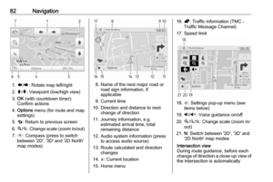 82
82 83
83 84
84 85
85 86
86 87
87 88
88 89
89 90
90 91
91 92
92 93
93 94
94 95
95 96
96 97
97 98
98 99
99 100
100 101
101 102
102 103
103 104
104 105
105 106
106 107
107 108
108 109
109 110
110 111
111 112
112 113
113 114
114 115
115 116
116 117
117 118
118 119
119 120
120 121
121 122
122 123
123 124
124 125
125 126
126 127
127 128
128