2015 MERCEDES-BENZ SLS AMG GT ROADSTER navigation system
[x] Cancel search: navigation systemPage 79 of 202

If
COMAND isunabl eto find anydestination,
a messag eto that effect willbe disp layed.
X Select OK .
X Ifnecessary ,select another category .
If COMAND findsdestinations, alist is
disp layed inthe right-hand partofthe
screen. Hereyouwillfind thestopover
destinations inthe selected category.
The listshows
R Name
R Information onthe location ofthe stopover
destination inrela tion tothe direction of
travel andthe
R Cu rrent distance tothe stopover
destination.
X To choo sead esti nation: Rotat eymzor
slide qmr .
X To select ad esti nation: Pressn.
The Enter Des tinatio nm enu appears and
displays theaddress ofthe destin ation.
X To cancel aselection :Sele ctBac k .
X To sta rtrou tecalcul ation: SelectSta rt .
Enter ingAnoth erDestin ation as
St opover Destination X
Ifnec essar y,swit chtonav igat ionmode
and display menusyst em(Ypage 57).
X Sele ctDes tin ation £
Stopover .
X To enter :Sele ctOTH ER .
Choos efro m:
R Add ressEnt ry R
Fro mMem ory R
Fro mLas tDes tination R
Fro mPOI s X
Sele ctamen uite m.
The rest ofthedest inationentrywill vary
depen dingontheselec tionm ade:
For theAdd ressEnt ry opt
ion see:
En terin gadest inationviaaddre ss
(Y page 66).
For theFro mMem ory opt
ion see: En
terin gadest inationfrom thedest ination
mem ory(Ypage 74).
For theFro m Las
t Des
tination opt
ion see:
En terin gadest inationfrom thelast
dest inations(Y page 75).
For theFro mPOI s opt
ion see:
En terin gaPOI (Ypage 78).
X To star trou tecalcu lation: Select Start .
Deleti ngStopov erDest ination An
exist ing stopov erdest inationcan be
delet ed.
X Swit chtonav igat ionmod eif ne ces sary.
X Sel ect Destination £
Stopover £
Del ete Stopover .
COMA NDdelet esthest opov erdest ination
and recalculat estherout eto themain
dest ination. Mbr
ace
Sear ch&S end i
Inorde rto utiliz eSear ch&Sen dyour
vehi clemust beequipped withmbrace,
nav igat ion,and anact ive mbr ace
subsc ription.
“Se arch&S end” isanavigation destination
address entryservic e.Ad estin ation address
located usingGoogle Maps®
can bedelivered
via mbrace directlyto the navigation system
in your vehicle.
Specify andSend aDesti nation Add ress
i Please referto any spec ificinstruct ions
prov ided onGoogle' swebsit eregar ding
ent erin gor sen ding anaddres s.The
websit esfun ction differen tlyand are
subj ecttochan ge.
X Go tohttp://m aps.g oogle.com andenter
a dest inationaddres sin thea ddress entry
field.
X Locat eand click on“Sen d”.Adialog box
appears. Destina
tionInput
77Navigat ion Z
Page 80 of 202
X
Sel ect car.
X Sel ect “Me rced es-Be nz”from the"ma ke"
dro p-do wnmenu .
X Enter theema ilad dre ssyouspe cifiedwhen
yo uacti vate dyo ur mbra ceacco untinthe
ap pro priate field.
X Click “Send ”.
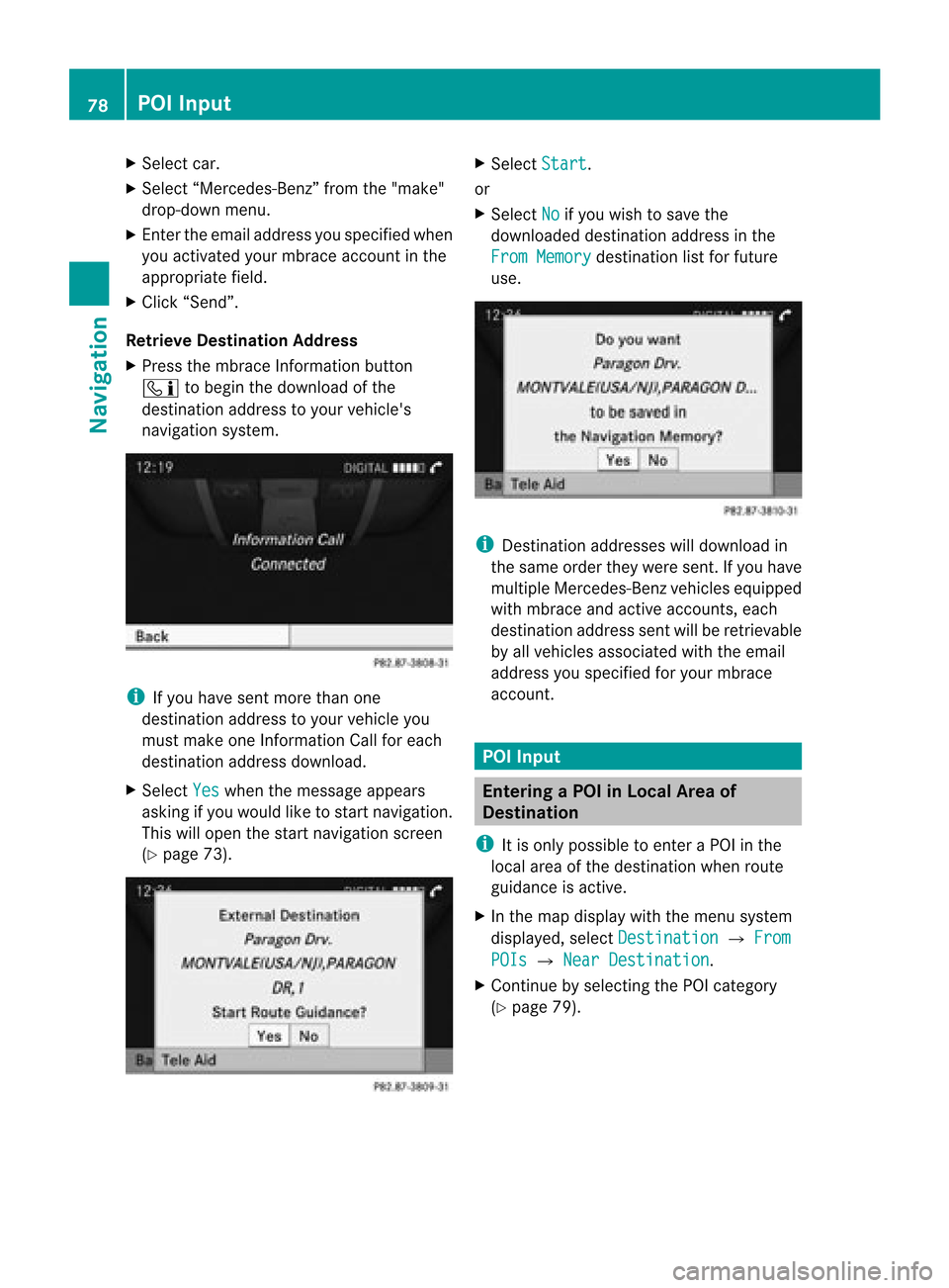
Retri eveDe stinati onAddre ss
X Pre ssthe mbra ceInfor mationbutton
ï tobegint he download ofthe
destination addresstoyour vehicle's
navigation system. i
Ifyou have sentmore thanone
destination addresstoyour vehicle you
must make oneInform ationCallforeach
destination addressdownload.
X Select Yes when
themessage appears
asking ifyou would liketostart navigation.
This willopen thestart navigation screen
(Y page 73). X
Select Start .
or
X Select No if
you wish tosave the
downloaded destinationaddressinthe
From Memory destination
listforfuture
use. i
Destin ationaddresses willdownload in
the same ordertheywere sent. Ifyou have
multiple Mercedes-Ben zvehicles equipped
with mbrace andactive accoun ts,each
destin ationaddress sentwillberetr ievable
by allvehicles associated withtheemail
address youspecified foryour mbrace
accoun t. POI
Input Entering
aPOIinLocal Areaof
Destination
i Itis only possible toent eraPOI inthe
local areaofthe destin ationwhen route
guidance isactive.
X In the map display withthemenu system
displayed, selectDestina tion £
From POIs £
Near Destina tion .
X Contin uebyselect ingthe POI categor y
(Y page 79). 78
POI
InputNavigation
Page 81 of 202
Ent
erin gaP OIinthe Vicinity ofthe
Location
X In the map display withthemenu system
displayed, selectDestina tion £
From POIs £
Current Position .
X Contin uebyselect ingthe POI categor y
(Y page 79). Entering
aPOIinthe Vicinity ofa
Specific Location
i Using thisoption youwillgetalist of
alphabetically sortedPOIs thatbelong to
the city entered.
Opt ion 1 X
In the map display withthemenu system
displayed, selectDestina tion £
From POIs £
Other City .
X Ifnec essary proceed asdescribed under
“Select ingaSt ate/Pr ovince”(Y page 66).
X To enter acity: Select City .
The cityinput menu appears.
X Proceed asdescribed inthe “Enterin ga
City” section(Ypage 67).
X Aft erent ering thecity, continue by
select ingthe POI categor y(Y page 79).
Opt ion 2 X
En ter anaddress inthe Enter Dest ination
menu (Ypage 66).
X Select POI .
X Contin uebyselect ingthe POI categor y
(Y page 79). Entering
POIsviaNam eSearch
i This function gives youaccess toall POIs
that areavailable inthe digital map. X
In the map display withthemenu system
displayed (Ypage 57),select Destina tion £
From POIs £
Search ByName .
This displays alist ofall POIs inthe digital
map andthepredict ivespeller.
X Contin ueasdescribed inthe “POI Listwith
Predict iveSpeller” section(Ypage 82). Entering
aPOIvia Phone Number
Search
i This function gives youaccess toall POIs
in the digital mapstoredwith aphone
number.
X In the map display withthemenu system
displayed (Ypage 57),select Destina tion £
From POIs £
Search ByPhone Number .
This displays alist ofall POIs inthe digital
map sortedbyphone number andthe
predict ivespeller.
X Contin ueasdescribed inthe “POI Listwith
Predict iveSpeller” section(Ypage 82). Choosing
aPOICategory
The categor iesand POIs available dependon
the area forwhich youwish toent erthe POI.
R POI inlocal areaofdestin ation:
Alphabetic allysortedcategor iesand POIs
sort edbydistanc ein the vicin ityofthe
destin ationlocation areavailable.
R POI inthe vicin ityofthe location :
Alphabetic allysortedcategor iesand POIs
sort edbydistanc ein the vicin ityofthe
vehicle location areavailable.
R POI inaparticular city:
If you have onlyentered thecount ryand the
city, alphabetically sortedcategor iesand
alphabetically sortedPOIs within thecity
limits areavailable.
If you have entered more thanthecount ry
and thecity, alphabetically sorted
categor iesand POIs sortedbydistanc ein POI
Input
79Navigation Z
Page 87 of 202
regu
lations duringyou rjourney. Roadand
traffic rulesandregulations alwayshave
priority overthenavigation commands
generated bythe system.
COMAND guidesyoutothe destination by
means ofdriving recommen dationsinthe
form ofnavigation announcementsor route
guidance displays.
i The route guidance displaysonly appear
if the display hasbeen switched to
navigation mode.
If, for some reason, youdonot follow the
navigation announcementsor ifyou leave the
calculated route,COMAND automatically
calculates anew route tothe destination .
If the map data contains correspon ding
informat ionduring routeguidance, COMAND
tries toavoid roads withlimited passabil ity,
e.g. roads thatareblocked forthrough-t raffic
and areforresidents only. Driving
Maneuver
Drivin gmaneuvers aregiven inthree phases:
R Preparation phase
R Ann ouncemen tphase
R Maneuver phase
Prepa ration Phase COMAND
preparesyouforthe next driving
maneuver. Basedonthe example display
shown below, theannounc ementismade
using Prepare toturn right .T
he displa y
is not split anddispla ysthe map overthe
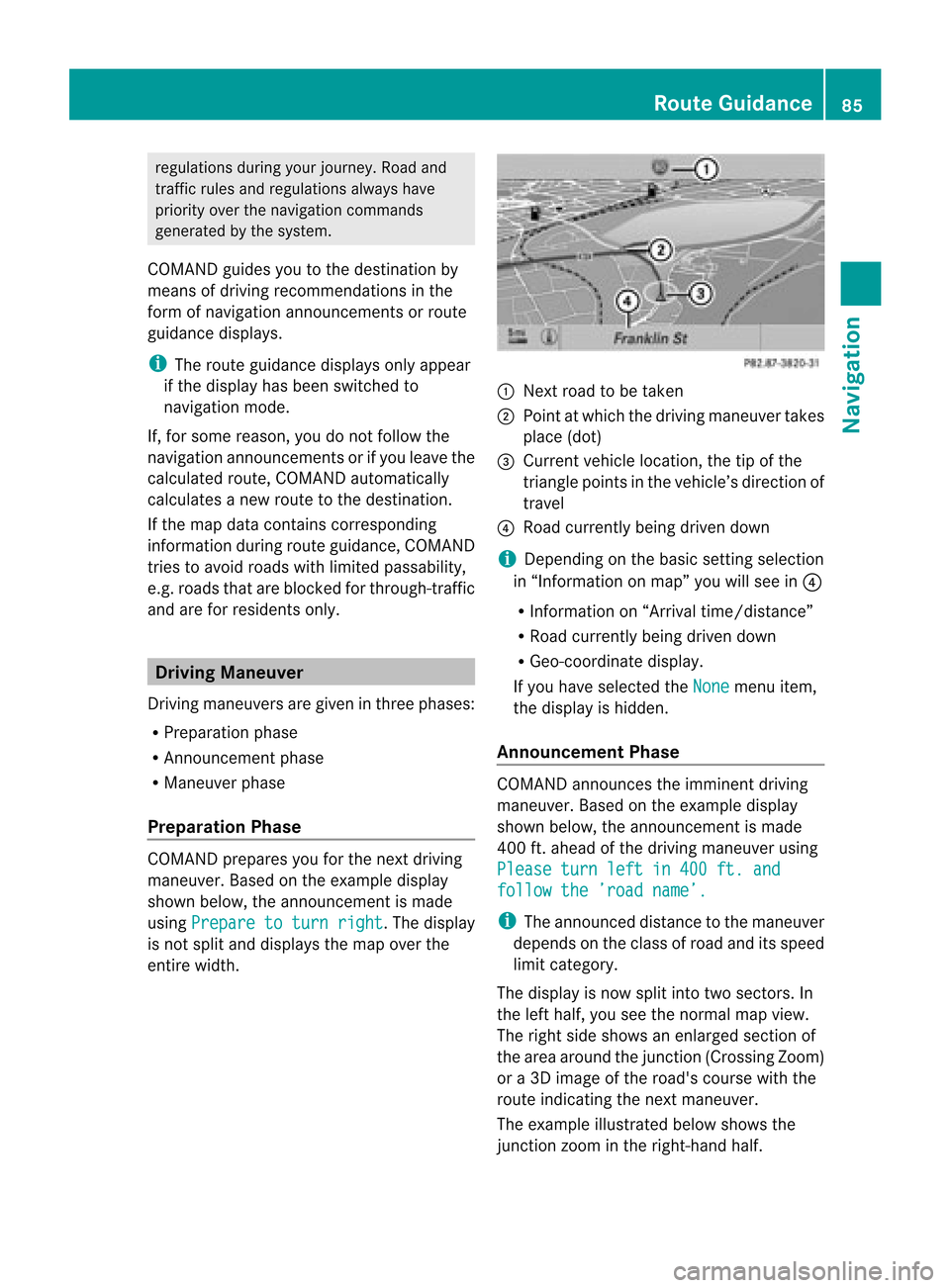
entire width. 1
Next roadtobe taken
2 Point atwhich thedriving maneuver takes
place (dot)
3 Current vehiclelocation, thetipofthe
triangle pointsinthe vehicle’s direction of
travel
4 Road current lybeing driven down
i Depending onthe basic settingselection
in “Inform ationonmap” youwillsee in4
R Inform ationon“Arrival time/distanc e”
R Road current lybeing driven down
R Geo-coordinate display.
If you have selected theNone menu
item,
the displa yis hidden.
Announc ementPhase COMAND
announces theimminent driving
maneuver. Basedonthe example display
shown below, theannouncemen tismade
400 ft.ahead ofthe driving maneuver using
Please turnleftin400 ft.and follow
the’road name’. i
The announced distancetothe maneuver
depends onthe class ofroad anditsspeed
limit category.
The displa yis now split intotwosectors. In
the left half, youseethenormal mapview.
The right sideshows anenlarged sectionof
the area around thejunct ion(Crossing Zoom)
or a3D image ofthe road's course withthe
route indicating thenext maneuver.
The example illustrated belowshows the
junct ionzoom inthe right-hand half. Route
Guidance
85Navigation Z
Page 89 of 202
Traffi
cLan eRec omme ndations
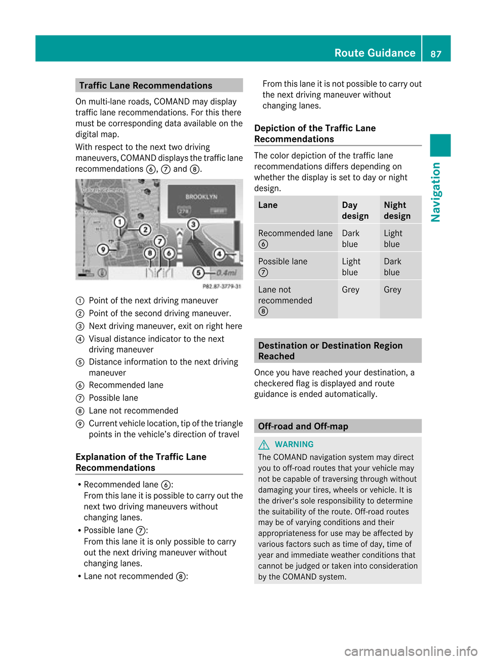
On multi-la ne roa ds,CO MAND maydi sp lay
tra fficlane reco mme ndations. For thisther e
mu stbe corr espond ingdata availabl e on the
di gital map.
Wi th res pect to the next twodriving
ma neu vers,CO MAND disp lays the trafficl ane
rec omm endat ions6, 7and 8. 1
Poin tof thene xt driv ingman euver
2 Poin tofthe second drivingmaneuver.
3 Next driving maneuver, exitonright here
4 Visual distance indicator tothe next
driving maneuver
5 Distanc einformation tothe next driving
maneuver
6 Recommended lane
7 Possible lane
8 Lane notrecommen ded
9 Current vehiclelocation, tipofthe triangle
points inthe vehicle’s direction oftravel
Explanation ofthe Traffic Lane
Recommendat ions R
Recommended lane6:
From thislane itis possible tocarry outthe
next twodriving maneuvers without
changing lanes.
R Possible lane7:
From thislane itis only possible tocarry
out thenext driving maneuver without
changing lanes.
R Lane notrecommen ded8: From
thislane itis not possible tocarry out
the next driving maneuver without
changing lanes.
Depictio nof the Traffic Lane
Recommendat ions The
color depiction ofthe traffic lane
recommen dationsdiffersdepending on
whether thedispla yis set today ornight
design. Lane Day
design Night
design Recommended
lane
6 Dark
blue Light
blue Possible
lane
7 Light
blue Dark
blue Lane
not
recommen ded
8 Grey Grey
Destination
orDestination Region
Reached
Once youhave reached yourdestination, a
check eredflagisdispla yedand route
guida nceisended automatically . Off-r
oadand Off-m ap G
WARNING
The COMAND navigation systemmaydirect
you tooff-road routesthatyour vehicle may
not becapable oftraversing throughwithout
damaging yourtires, wheels orvehicle. Itis
the driver's soleresponsibility todetermine
the suitabili tyof the route. Off-roadroutes
may beofvarying condition sand their
appropriateness foruse may beaffected by
various factorssuchastime ofday, time of
year andimmediate weathercondition sthat
cannot bejudged ortaken intoconsideration
by the COMAND system. Route
Guidance
87Navigation Z
Page 90 of 202
Route
Guidanceto an Off-ro ad
De stin atio n CO
MAND canalso guide yo uto des tina tions
that arewithin theareacovered bythe digital
map, butarenot themselves includedonthe
map. Such destinat ionsareoff-road
destinat ions,which youcan enter ,for
example, byenter ingthe destination viathe
map.
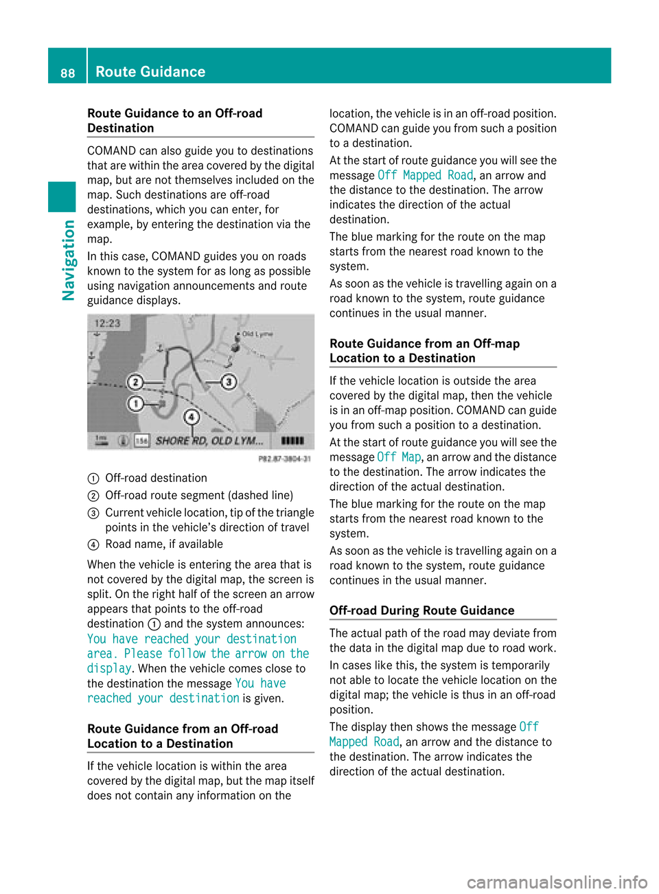
In this case, COMAND guidesyouonroads
known tothe system foraslong aspossible
using navigation announcementsand route
guidance displays. 1
Off- road destinat ion
2 Off- road route segment (dashedline)
3 Current vehiclelocation, tipofthe triangle
points inthe vehicle’s direction oftravel
4 Road name, ifavaila ble
When thevehicle isenter ingthe area thatis
not covered bythe digital map,thescreen is
split. Onthe right halfofthe screen anarrow
appears thatpoints tothe off-road
destinat ion1and thesystem announc es:
You have reached yourdestination area. Please follow the arrow on the
display .W
hen thevehicle comescloseto
the destination themessage Youhave reached
yourdestination is
given.
Route Guidance fromanOff-r oad
Location toaD esti nation If
th eveh icle locat ioniswith inthearea
cov ered bythedigit almap, butthemap itself
does notcon tain anyinform ationon the loc
atio n,thevehi cleisin an off-road posit ion.
COMA NDcan guide youfrom such aposit ion
to adest ination.
At thest art ofrout eguidan ceyou willsee the
mes sage OffMapped Road ,
an arro wand
th edist anceto thedest ination.The arrow
indicates thedirection ofthe actual
destination.
The blue marking forthe route onthe map
starts fromthenearest roadknown tothe
system.
As soon asthe vehicle istravelling againona
road known tothe system, routeguidance
cont inues inthe usua lmanner.
Route Guidance fromanOff-m ap
Location toaD esti nation If
th evehi clelocatio niso uts ide thearea
co ver edbythedigit almap, then theveh icle
is in an off-map posi tion .C OMAND canguide
you from such aposition toadestination.
At the start ofroute guidanceyouwillsee the
message Off Map ,
an arrow andthedistance
to the destination. Thearrow indicates the
direction ofthe actual destination.
The blue marking forthe route onthe map
starts fromthenearest roadknown tothe
system.
As soon asthe vehicle istravelling againona
road known tothe system, routeguidance
continues inthe usualmanner.
Off-road DuringRouteGuidance The
actua lpath ofthe road maydeviatefrom
the data inthe digitalmap duetoroad work.
In cases likethis, thesystem istempora rily
not ableto loca tethe vehicl eloca tion onthe
digi talmap; thevehicl eis thus inan off-road
posi tion.
The displaythen show sthe messa geOff Mapped
Road ,
an arrow andthedista nceto
the destina tion.Thearrow indicatesthe
dire ction ofthe actua ldestina tion. 88
Route
GuidanceNavigatio n
Page 91 of 202
As
soo nasthe vehicle location isfound again,
route guidancecont inues inthe usua l
manner. Navigation
Announcements G
WARNING
Navigation announcement sare intended to
direct youwhile driving without diverting your
attent ionfrom theroad anddriving.
Please alwaysuse this feature instead of
consulting themap displa yfor directions.
Consulting thesymbols ormap displa yfor
directions maycause youtodivert your
attent ionfrom driving andincrease yourrisk
of an accident.
i During anactive telephone call,the
navigation announcement sare
suppressed .
If you have missed anannouncement ,you can
call upthe current announcement atany
time.
X To request currentannounce ment:In
map view withthemenu system
(Y page 58)displa yed,select RPT .
X To switch offnavigation
announce ments:Duringthe
announcement ,press theBbutton.
You willbriefly seethemessage: The driving
instructions havebeen muted .
X To switch navigation announcements
back onmanually: Inmap view withthe
menu system (Ypage 58)displa yed,select
RPT .
or
X Start anew route calcula tion(Ypage 73).
or
X IfCOMAND isswitched onagai northe
engine isrestarted. X
To set the volume ofthe
announcements: Setthevolume during
the automatic announcemen t(Y page 36).
or
X Call upanannouncemen tmanually by
selec tingRPT in
map view withth emen u
syst emdispl ayed.
X Ad jus tthe volume.
Audio Fadeout The
Audio Fadeout function,ifactivated,
lowers thevolume ofthe current audiosource
when anavigation announcemen tisissued.
As soon asthe navigation announcement has
ended, theaudi osource willbeplay edwith
the previous volume(Ypage 36). Cance
lingRoute Guidance
X In the map displa ywith themenu system
displa yed(Ypage 58)select Destination £
Cancel RouteGuidance .
Resuming RouteGuidance X
Select Destination £
Continue Route
Guidance in
map view withthe
menu system displayed.
COMAND calculatesthe route. Detour
Function
i The Detour function blocksaroute
segment ahead.You can setthe length of
the block. COMAND calculates adetour
route ifpossible.
X Select Route £
Detour in
map view with
the menu system displayed.
X To set the length ofblock: Select
Longer or
Shorter repeatedly
untilthe
required lengthisset.
The blocked segment ishighlighted inred/
white onthe map. Shown atthe top ofthe
display isthe length ofthe blocked Rout
eGuida nce
89Navigation Z
Page 93 of 202
3
Main destination
4 Distanc e/estimated timeofarrival/
estimated journeytimetothe main
destination <
i When calculating theestimated timeof
arrival, COMAND usesthetime setonthe
COMAND asits basis. Forthis reason, the
time onCOMAND mustbeset correct ly
(Y page 43).Thecalculation ofthe
estimated timeofarrival doesnot
specifically takeintoconsideration
whether itis dayl ight saving timeor
standard timeatthe destination. Itis not
taken intoconsideration whetherornot the
destination isin adifferent timezone. The
distance tothe destination, theestimated
time ofarrival andtheestimated remaining
journey time1,4are not displa yeduntil
the route calculation iscomplete.
X To close thedestination information:
Slide omp .
or
X Press thek button . Tr
affic Messages
i Optional satelliteradioequipment anda
subscription toSIRIUS XMSatellite Radio
service provider arerequired forthe
satellite radioreception referredtohere.
You canfind more inform ationonSatRadio
in chapter “Satellite Radio”(Ypage 185).
COMAND canreceive andincorpor atetraffic
messages viasatellite radiointothe
navigation system.Trafficreportmessages
and map symbols canthen beviewed inthe
COMAND display. Real-T
imeTraffic Notificat ionsinthe
Map
COMAND candisplay certaintraffic eventsin
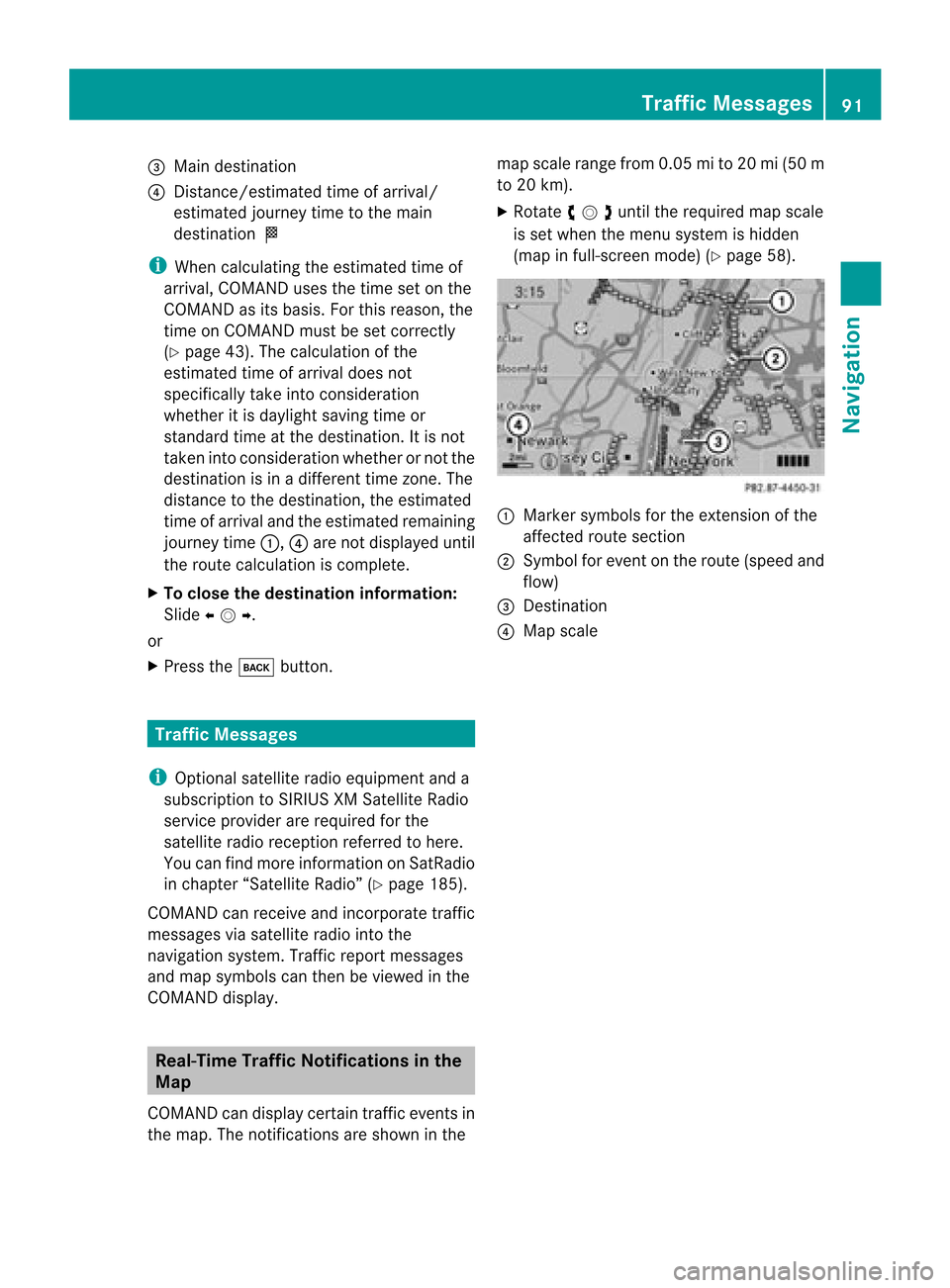
the map. Thenotifications areshown inthe map
scale range from0.05mi to20 mi(50 m
to 20 km).
X Rotate ymzunt ilth ereq uired mapscale
is set when themen usyst emishidde n
(map infull- scree nm ode) (Ypage 58). 1
Marker symbols forthe exten sionofthe
affect edroute section
2 Symbol forevent onthe route (speed and
flow)
3 Dest ination
4 Map scale Tr
affic Messages
91Navigation Z