Page 103 of 221
Digital picture frame103
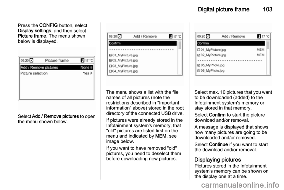
Press the CONFIG button, select
Display settings , and then select
Picture frame . The menu shown
below is displayed.
Select Add / Remove pictures to open
the menu shown below.
The menu shows a list with the file
names of all pictures (note the
restrictions described in "Important information" above) stored in the root directory of the connected USB drive.
If pictures were already stored in the
Infotainment system's memory, that
"old" pictures are listed first on the menu and indicated by MEM, see
image below.
If you want to have removed "old"
pictures, you need to deselect them
before downloading new pictures.Select max. 10 pictures that you want
to be downloaded (added) to the
Infotainment system's memory or
stay stored in that memory.
Select Confirm to start the picture
download and/or removal.
A message is displayed that shows
how many pictures are going to be
downloaded and/or removed.
Select Continue if you want to start
the download and/or removal.
Displaying pictures Pictures stored in the Infotainment
system's memory can be shown on
the display one at a time.
Page 104 of 221
104Digital picture frame
Press the CONFIG button, select
Display settings , select Picture
frame , and then select Picture
selection . The menu shown below is
displayed.
Select the picture you want to be
shown on the display.
Press the INFO button several times
until the currently selected picture is
shown on the display.
To display a default Infotainment
menu again, press any button on the
Infotainment system.
As long as a picture stays selected in
the Picture selection menu, it can be
displayed at any time using the
INFO button.
Page 106 of 221

106Navigation
After the entry of the destination
address or point of interest (nearest
petrol station, hotel, etc.) the route is
calculated from the current location to the destination selected.
The route guidance is provided by
voice output and an arrow, as well as
with the aid of a multi-colour map
display.
TMC traffic information system
and dynamic route guidance
The TMC traffic information system receives all current traffic informationfrom TMC radio stations. If dynamic
route guidance is active, this
information is included in the
calculation of the overall route. During
this process, the route is planned so
that traffic problems related to pre-
selected criteria are avoided.
If there is a traffic problem during
active route guidance, depending on
the pre-settings, a message appears as to whether the route should be
changed.TMC traffic information is displayed in
the route guidance display as
symbols or as detailed text on the
TMC messages menu.
To be able to use TMC traffic
information, the system has to receive TMC stations in the relevant region.
Dynamic route guidance only works if
traffic information is received via the
TMC traffic information system.
The dynamic route guidance function
can be deactivated in the Navigation
options menu, see chapter
"Guidance" 3 129.
Map data All required map data is stored on an
SD card provided with the
Infotainment system.
Detailed descriptions on map SD card
handling and replacement, see
chapter "Maps" 3 136Usage
Control elements The most important navigation-
specific control elements are as
follows:
NAV button: activate navigation;
show current position (if route
guidance inactive); show calculated
route (if route guidance active); toggle between full map display, arrow
display (if route guidance active) and
split screen display, see "Information
on the display" below.
DEST / NAV button: open menu with
options for destination entry.
Eight-way switch: move display
window in navigation map view; to
select the destination, press in the
required direction to position the
crosswires over a destination on the map.
RPT / NAV button: repeat last route
guidance message.
Activating the navigation system Press the NAV button.
Page 107 of 221
Navigation107
The map of the current location is
shown on the display, see
"Information on the display" below.
Route guidance messagesIn addition to the visual instructions
on the display (see "Information on
the display" below), route guidance
messages will be announced when
route guidance is active.
Presetting the volume of route
guidance messages: see "Setting up
the navigation system" below.
Adjusting the volume of route
guidance messages while they are
announced: turn the X VOL knob.
Repeating the last announced route guidance message: press the RPT /
NAV button.Information on the display
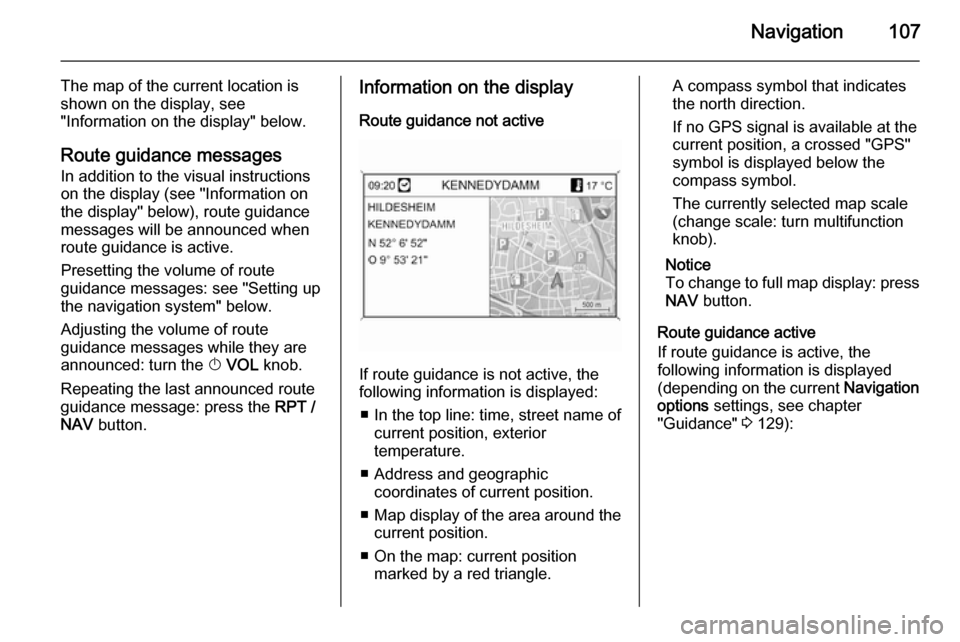
Route guidance not active
If route guidance is not active, the
following information is displayed:
■ In the top line: time, street name of current position, exterior
temperature.
■ Address and geographic coordinates of current position.
■ Map display of the area around the
current position.
■ On the map: current position marked by a red triangle.
A compass symbol that indicates
the north direction.
If no GPS signal is available at the current position, a crossed "GPS"
symbol is displayed below the
compass symbol.
The currently selected map scale
(change scale: turn multifunction
knob).
Notice
To change to full map display: press
NAV button.
Route guidance active
If route guidance is active, the
following information is displayed (depending on the current Navigation
options settings, see chapter
"Guidance" 3 129):
Page 108 of 221
108Navigation
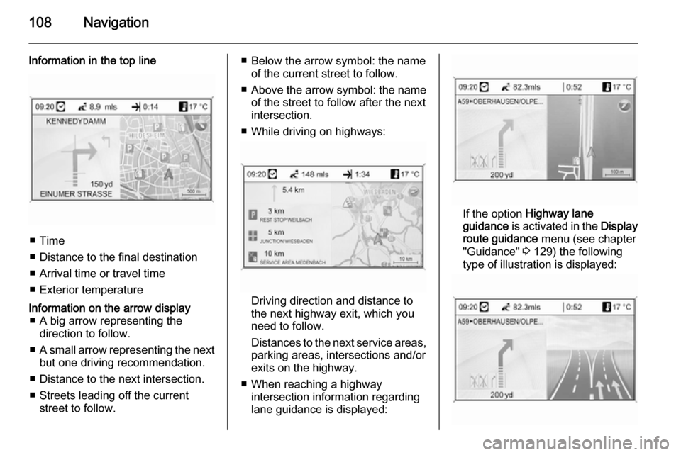
Information in the top line
■ Time
■ Distance to the final destination
■ Arrival time or travel time
■ Exterior temperature
Information on the arrow display ■ A big arrow representing the direction to follow.
■ A small arrow representing the next
but one driving recommendation.
■ Distance to the next intersection.
■ Streets leading off the current street to follow.■ Below the arrow symbol: the nameof the current street to follow.
■ Above the arrow symbol: the name
of the street to follow after the next
intersection.
■ While driving on highways:
Driving direction and distance to
the next highway exit, which you
need to follow.
Distances to the next service areas, parking areas, intersections and/or
exits on the highway.
■ When reaching a highway intersection information regarding
lane guidance is displayed:
If the option Highway lane
guidance is activated in the Display
route guidance menu (see chapter
"Guidance" 3 129) the following
type of illustration is displayed:
Page 109 of 221
Navigation109
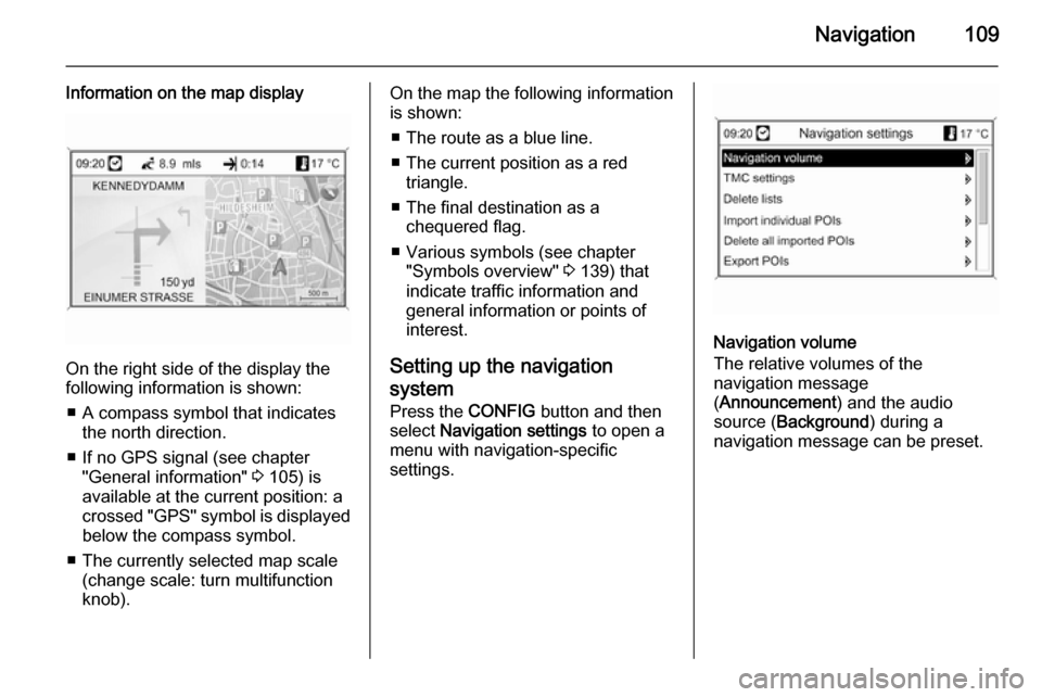
Information on the map display
On the right side of the display the
following information is shown:
■ A compass symbol that indicates the north direction.
■ If no GPS signal (see chapter "General information" 3 105) is
available at the current position: a
crossed "GPS" symbol is displayed
below the compass symbol.
■ The currently selected map scale (change scale: turn multifunction
knob).
On the map the following information
is shown:
■ The route as a blue line.
■ The current position as a red triangle.
■ The final destination as a chequered flag.
■ Various symbols (see chapter "Symbols overview" 3 139) that
indicate traffic information and
general information or points of
interest.
Setting up the navigation
system Press the CONFIG button and then
select Navigation settings to open a
menu with navigation-specific
settings.
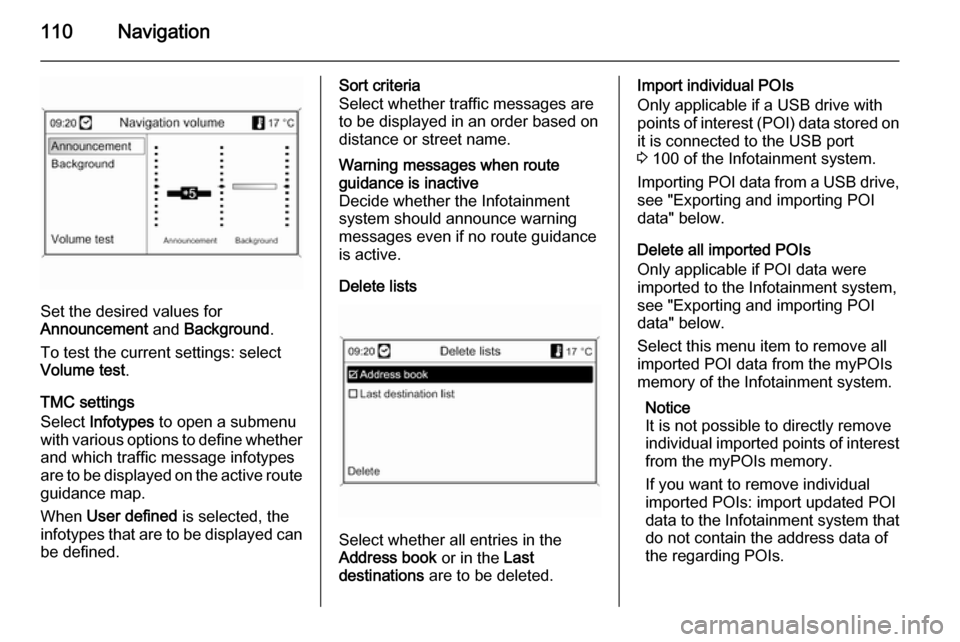
Navigation volume
The relative volumes of the
navigation message
( Announcement ) and the audio
source ( Background ) during a
navigation message can be preset.
Page 110 of 221
110Navigation
Set the desired values for
Announcement and Background .
To test the current settings: select Volume test .
TMC settings
Select Infotypes to open a submenu
with various options to define whether
and which traffic message infotypes
are to be displayed on the active route guidance map.
When User defined is selected, the
infotypes that are to be displayed can
be defined.
Sort criteria
Select whether traffic messages are
to be displayed in an order based on
distance or street name.Warning messages when route
guidance is inactive
Decide whether the Infotainment
system should announce warning
messages even if no route guidance
is active.
Delete lists
Select whether all entries in the
Address book or in the Last
destinations are to be deleted.
Import individual POIs
Only applicable if a USB drive with
points of interest (POI) data stored on
it is connected to the USB port
3 100 of the Infotainment system.
Importing POI data from a USB drive,
see "Exporting and importing POI
data" below.
Delete all imported POIs
Only applicable if POI data were
imported to the Infotainment system,
see "Exporting and importing POI
data" below.
Select this menu item to remove all
imported POI data from the myPOIs
memory of the Infotainment system.
Notice
It is not possible to directly remove
individual imported points of interest from the myPOIs memory.
If you want to remove individual
imported POIs: import updated POI
data to the Infotainment system that
do not contain the address data of
the regarding POIs.
Page 111 of 221

Navigation111
To remove all imported POIs of a
certain category: import an empty
POI data file of the regarding
category to the Infotainment system.
Export POIs
Exports all POI data stored in the
myPOIs memory of the Infotainment
system to a USB drive connected to
the USB port 3 100, see "Exporting
and importing POI data" below.
Delete Home address
Deletes the currently set home
address (displayed in the Enter
destination menu, see chapter
"Destination input" 3 115).
Exporting and importing POI data
Introductory explanationsTypes of POI data
The Infotainment system provides the following types of points of interest
data:
■ Predefined Points of Interest stored
on the map SD card and indicated
by icons on the map display.You can store such predefined
POIs in the address book or as
individual POIs in the myPOIs
memory of the Infotainment
system, see below.
■ Favourite destination addresses that were stored in the Address
book .
You can export these address book
data to a USB drive for later use,
e.g., in other vehicles.
■ Individual POIs : favourite
destination addresses that were
stored in the myPOIs memory.
You can export these individual
POI data to a USB drive for later
use, e.g., in other vehicles.
■ User defined POIs : favourite
destination addresses that you
defined via GPS coordinates
(taken, e.g., from a topographical
map) and that you entered into text files.
You can store these user defined
POI data on a USB drive and later
import the data to the myPOIsmemory of the Infotainment
system, see below.
■ Imported POIs : favourite
destination addresses that were
previously stored on a USB drive
and then imported to the myPOIs
memory of the Infotainment
system.Advantages of POI export and import The export and import of points of
interest data offer you, e.g., the
following advantages:
■ Define and store your favourite destination addresses only once,
and later use these address data in
other vehicles.
See "Exporting and importing
individual POIs and address book
entries" below.
■ Define your favourite destination addresses conveniently at home,
and later use them in your vehicle.
See "Creating and importing user
defined POIs" below.
■ Clearly arrange a large amount of destination addresses, e.g.,
favourite destination addresses of