2014 MITSUBISHI MIRAGE AUX
[x] Cancel search: AUXPage 20 of 135

20
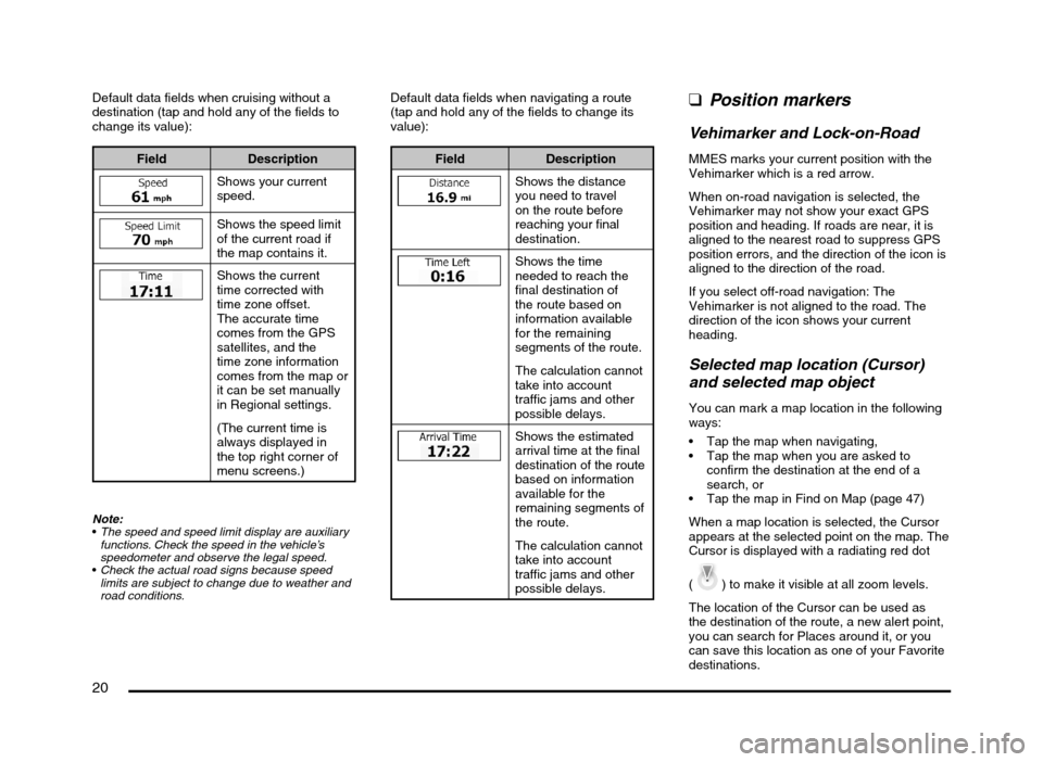
Default data fields when cruising without a
destination (tap and hold any of the fields to
change its value):
Field Description
Shows your current
speed.
Shows the speed limit
of the current road if
the map contains it.
Shows the current
time corrected with
time zone offset.
The accurate time
comes from the GPS
satellites, and the
time zone information
comes from the map or
it can be set manually
in Regional settings.
(The current time is
always displayed in
the top right corner of
menu screens.)
Note:
The speed and speed limit display are auxiliary
functions. Check the speed in the vehicle’s
speedometer and observe the legal speed.
Check the actual road signs because speed
limits are subject to change due to weather and
road conditions.
Default data fields when navigating a route
(tap and hold any of the fields to change its
value):
Field Description
Shows the distance
you need to travel
on the route before
reaching your final
destination.
Shows the time
needed to reach the
final destination of
the route based on
information available
for the remaining
segments of the route.
The calculation cannot
take into account
traffic jams and other
possible delays.
Shows the estimated
arrival time at the final
destination of the route
based on information
available for the
remaining segments of
the route.
The calculation cannot
take into account
traffic jams and other
possible delays.
qPosition markers
Vehimarker and Lock-on-Road
MMES marks your current position with the
Vehimarker which is a red arrow.
When on-road navigation is selected, the
Vehimarker may not show your exact GPS
position and heading. If roads are near, it is
aligned to the nearest road to suppress GPS
position errors, and the direction of the icon is
aligned to the direction of the road.
If you select off-road navigation: The
Vehimarker is not aligned to the road. The
direction of the icon shows your current
heading.
Selected map location (Cursor)
and selected map object
You can mark a map location in the following
ways:
Tap the map when navigating,
Tap the map when you are asked to
confirm the destination at the end of a
search, or
Tap the map in Find on Map (page 47)
When a map location is selected, the Cursor
appears at the selected point on the map. The
Cursor is displayed with a radiating red dot
(
) to make it visible at all zoom levels.
The location of the Cursor can be used as
the destination of the route, a new alert point,
you can search for Places around it, or you
can save this location as one of your Favorite
destinations.
205-0010-00_QY-7375M-A_EN.indb 20205-0010-00_QY-7375M-A_EN.indb 203/12/2013 9:57:15 AM3/12/2013 9:57:15 AM
Page 62 of 135

62
For some of the alert points, the enforced or
expected speed limit is available. For these
points, the audio alert can be different if you
are below or above the given speed limit.
Only when speeding: The audio alert is
only played when you exceed the given
speed limit.
When approaching: The audio alert is
always played when approaching one of
these alert points. In order to draw your
attention, the alert is different when you
exceed the speed limit.
qSpeed limit warning
Maps may contain information about the
speed limits of the road segments. MMES is
able to warn you if you exceed the current
limit. This information may not be available for
your region, or may not be fully correct for all
roads in the map.
Speed warning can be fine-tuned in Sound
and Warning settings (page 66).
You can set the relative speed above which
the application initiates the warning.
The following alert types are available:
Audio warning: you receive a verbal
warning when you exceed the speed limit
with the given percentage.
Visual warning: the current speed limit is
shown on the map when you exceed it
(for example:
).
You can also choose to see the speed limit
sign on the map all the time.
Note:
The speed limit warning is an auxiliary function.
Check the speed in the vehicle’s speedometer
and observe the legal speed.
qArrival notification
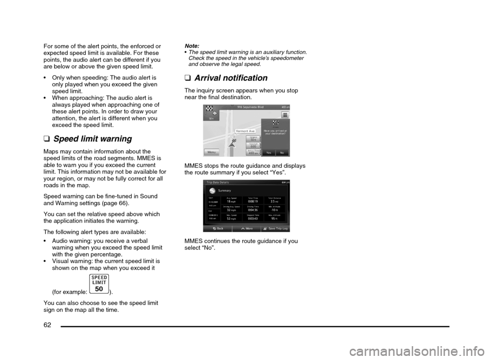
The inquiry screen appears when you stop
near the final destination.
MMES stops the route guidance and displays
the route summary if you select “Yes”.
MMES continues the route guidance if you
select “No”.
205-0010-00_QY-7375M-A_EN.indb 62205-0010-00_QY-7375M-A_EN.indb 623/12/2013 9:57:24 AM3/12/2013 9:57:24 AM
Page 83 of 135

83
The User hereby acknowledges that (i) inaccurate or incomplete information due to the passage of time, changing circumstances, sources
used and the nature of collecting comprehensive geographic data, may each lead to incorrect results; and (ii) that the Database, contents and
services provided by third parties may only be used at the risk of the User and for the personal or internal business benefit of the User. User
acknowledges that the Databases, content and services are the confidential information of Database Owners and disclosure of the Databases
to third parties is prohibited.
USE OF THE SOFTWARE PRODUCT’S REAL TIME ROUTE GUIDANCE FUNCTION IS AT USER’S SOLE RISK AS LOCATION DATA MAY
NOT BE ACCURATE.
9.4 Content and services provided by the Licensor or an agent of the Licensor. For certain Software Products the Licensor or a contractual partner
may offer various products and services to the User through clarion.naviextras.com. The User may only use these services when the User has
read and understood the relevant end user license agreement(s) at clarion.naviextras.com and the User is obliged to use the services in line
with the terms and conditions thereof.
9.5 Purchase and acquisition of activation license for the use of certain functions, Databases, content or services may require Internet connection
with no alternative way of acquisition offered by Licensor.
10 Anonymous data collection
10.1 The User hereby acknowledges that the Software Product may collect, transmit to Licensor or third parties, and in some cases store data
connected to the usage of the Software Product by the User (e.g. movement/route data, user interaction data). Such data collection functions
may be disabled or enabled by User any time from within the corresponding menu. The collected data is always anonymous, not associated in
any way with any personal information of the User or with the User itself.
10.2 The collected data may be uploaded to Licensor’s database or transmitted periodically or in real time to a third party partner and used
exclusively for the purpose of enhancing and improving the precision and reliability of features and services of the Software Product and the
Databases. Uploading is executed through Licensor’s special software or by the User navigation device, and the upload may be enabled or
disabled by User. After successful data upload, the collected data is deleted from the Software Product storage media.
10.3 Collected data is transmitted, stored and handled anonymously and no connection of the data with the User shall be established by Licensor or
any third party.
10.4 Licensor hereby informs the User, that if it accesses the Internet through mobile data service while abroad or otherwise roaming another mobile
network the transmission of such data may result in special roaming charges. To avoid such charges it is the responsibility of the User to
disable mobile data services while roaming or to turn off the data collection functions of the Software Product.
11 Online Content Service Auxiliary Terms
11.1 For online content services the following auxiliary terms shall also apply. Database content (e.g. weather-, location based info) may be supplied
by Licensor to the User’s Device through an Internet connection (hereinafter: “Online Content Services”). Such Content may be granted for a
fee or free of charge subject to Licensor’s decision. Ensuring access to the Internet is the responsibility of the User.
11.2 Online Content Services in general are not available in all countries, furthermore different conditions and Service characteristics may apply in
different countries. Use of certain Online Services may be prohibited in various countries. It is the User’s responsibility to comply with country
specific regulation. Licensor excludes its liability for the consequences of illegal use of such functions and User shall indemnify and hold
Licensor harmless from all claims against Licensor from authorities or third parties due to the illegal use.
205-0010-00_QY-7375M-A_EN.indb 83205-0010-00_QY-7375M-A_EN.indb 833/12/2013 9:57:25 AM3/12/2013 9:57:25 AM