Page 129 of 152
.
Enter")
128
Reference Information
System Initialization
The navigation system must be initialized if
power to the navigation system is
interrupted for any reason (e.g., the
battery was disconnected).
Entering the Security Code
Find the navigation system’s security code
and serial number label in your Owner’s
Manual kit. Do not store the label in your
vehicle. If you lose the label, you must first
retrieve the serial number, and then obtain
the code. You can find out about your
serial number and security code from a
dealer.
1. Set the power mode to ON, and turn on
the audio system.
If you set the power mode to
ACCESSORY, you will be requested
to enter the security code. See step 3.
2. Press and hold the PWR 9 (Power)
button for more th an two seconds.
The system is reactivated when the
system’s control unit recognizes that
the system is in your vehicle.
If the control unit fails to recognize,
“ENTER CODE” appears on the
navigation screen.
3. If necessary, enter the security code.
If you do not enter the security code
correctly after 10 tries, leave the
system for one hour before trying
again, or visit a dealer to have the
system reset.
NOTE:
In the U.S. you can register the security
code at Honda Owners
(owners.honda.com.), and find
information on how to retrieve the serial
number and obtain the code at radio-
navicode.honda.com .
Acquiring GPS Information
Depending on the length of time the
power was interrupted, your system may
require GPS initialization.
If initialization is not necessary, the system
proceeds directly to the Startup
Confirmation screen.
If the system fails to locate a sufficient
number of satellites to locate your position
within 10 minutes, the following screen is
displayed.
Page 130 of 152
129
System InitializationStartup Confirmation Screen
Reference Information
If you are experiencing GPS reception
problems:
2GPS System P. 130
Startup Confirmation
Screen
The Startup Confirmation screen is
displayed when initialization has
successfully completed. It is displayed every
time you start your vehicle. Press u to
select OK to continue.
Map Matching
Map matching is the process of using the
acquired GPS information to locate your
position on the map screen. If you are on a
mapped road, the name of the road is
displayed along the bottom of the map
screen when map matching is completed.
Do not enter a destination until the road
name is displayed.
The system may initially show your location
on a different street (e.g., in urban areas
where streets are close together), may
show an incorrect elevation, or may delay
the display of the vehicle position icon at
intersections. This is normal; the system
will correct itself while you drive.
Page 131 of 152
 and
require an")
130
Reference Information
System Limitations
GPS System
The signals received from the GPS satellites
are extremely weak (less than a millionth
of the strength of a local FM station) and
require an unobstructed view of the sky.
The GPS antenna is located in the
dashboard. The signal reception can easily
be interrupted or interfered with by the
following:
• Metallic window tint on the front or side
windows
• Cell phones, PDAs, or other electronic
devices docked in a cradle or lying loose
on the dashboard
• Remote starters or “hidden” vehicle
tracking systems mounted near the
navigation unit
• Audio electronic devices mounted near
the navigation unit
• Trees, tall buildings, freeway overpasses,
tunnels, or overhead electrical power
wires
The GPS is operated by the U.S.
Department of Defense. For security
reasons, there are certain inaccuracies built
into the GPS for wh ich the navigation
system must constantly compensate. This can cause occasional positioning errors of
up to several hundred feet.
Address Calculation
The destination icon shows only the
approximate location of a destination
address. This occurs if the number of
possible addresses is different from the
number of actual addresses on a block. For
example, the address 1425 on a 1400
block with 100 possible addresses
(because it is followed by the 1500 block)
will be shown a quarter of the way down
the block by the system. If there are only
25 actual addresses
on the block, the
actual location of address 1425 would be
at the end of the block.
Database
The digitized map database reflects
conditions as they existed at various points
in time before production. Accordingly,
your database may contain inaccurate or
incomplete data or information due to the
passage of time, road construction,
changing conditions, or other causes.
For example, some places/landmarks may
be missing when you search the database
because the name was misspelled, the
place was improperly categorized, or a
place/landmark is not yet in the database.
This is also true for police stations,
hospitals, and other public institutions. Do
not rely on the navigation system if you
need law enforcement or hospital services.
Always check with local information
sources.
Page 132 of 152

131
System LimitationsDatabase
Reference Information
In addition, the map database contains
verified and unverified areas. Unverified
streets may be missing from the map, in
the wrong location, or have an incorrect
name or address range. A message will
warn you if your route includes unverified
streets. Exercise additional caution when
driving in unve rified areas.
The database does not include, analyze,
process, consider, or reflect any of the
following categories of information:
• Neighborhood quality or safety
• Population density
• Availability or proximity of law
enforcement
• Emergency, rescue, medical, or other
assistance
• Construction work, zones, or hazards
• Road and lane closures
• Legal restrictions (such as vehicular type,
weight, load, height, and speed
restrictions)
• Road slope or grade
• Bridge height, width, weight, or other
limits
• Traffic facilities safety
• Special events •
Pavement characteristics or conditions
Every effort has been made to verify that
the database is accurate. The number of
inaccuracies you experience increases the
longer you go without obtaining an
updated map database.
2 Obtaining a Navigation Update P. 133
We assume no liability for any incident that
may result from an error in the program, or
from changed conditions not noted above.
Page 133 of 152

132
Reference Information
Customer Assistance
Resolving Problems
If you run into a specific issue that you
cannot resolve, consult the following help
resources:
• For navigation system issues:
2 Troubleshooting P. 120
There are also FAQs available online at
automobiles.honda.com.
• For traffic-related issues:
2 Traffic P. 122
• For reporting issues with the database
or places/landmarks:
2 Reporting Errors P. 132
• Call Honda Automobile Customer
Service.
2 Honda Automobile Customer Service
Contact Information
P. 132
Reporting Errors
You can help to improve database
accuracy by reporti ng any errors you
encounter.
• Report errors in freeways and main
“verified” roads shown in black on the
map at http://mapreporter.navteq.com/
dur-web-external/ .
• Please do not report errors in purple
“unverified” roads. Maps for these
areas are provided for reference only.
2 Unverified Routing P. 36
• Please do not report errors in places/
landmarks, such as changes in business
names. Information about points of
interest are constantly being updated.
An updated database is available for
purchase, usually in the fall of each year.
2 Obtaining a Navigation Update P. 133
• For vehicle position ic on errors, screen
error messages, or other GPS-related
errors:
2 Troubleshooting P. 120
2System Limitations P. 130
Honda Automobile
Customer Service Contact
Information
Honda Navi
American Honda Motor Co., Inc.
Honda Automobile Customer Service
Mail Stop 500-2N-7E
1919 Torrance Blvd.
Torrance, CA 90501-2746
Tel: (800) 999-1009
Fax: (310) 783-3273
Visiting a Dealer
If you have a question that you cannot
resolve using the available help resources,
you can consult a dealer. Please identify
the specific is sue (e.g., error occurs when
you enter a specific a ddress, when driving
on a certain road, or just when it’s cold) so
that the service technician can refer the
issue to the factory so that a solution can
be found. Be patient, the service technician
may be unfamiliar with your specific issue.
Page 134 of 152

133
Customer AssistanceMap Coverage
Reference Information
Map Coverage
The navigation system provides map
coverage for the United States, Canada,
Puerto Rico, and Mexico. The map
coverage consists of accurately mapped
(verified) metropolitan areas and a less
accurate (unverified) rural database. Note
that unverified areas are constantly being
reviewed and converted to verified areas
each year.
Map coverage update information is
available from Honda Automobile
Customer Service or online at
www.hondanavi.com .
To find navigation system update
information:
1. Visit www.hondanavi.com .
2. Enter your vehicle model and model
year.
3. Click Map Coverage to display a list of
verified coverage areas on the most
recent update.
4. Click Map Coverage Details to display a
PDF document with a full listing of all
coverage areas.
Adobe® Reader® is required for
viewing and printing the Portable
Document Format (PDF) documents.
To download the latest version of
Adobe Reader, visit http://
get.adobe.com/reader/ .
Obtaining a Navigation
Update
Honda is continually expanding the scope
of the navigation system. Navigation
system software upgrades may be made
available periodically, usually in the fall of
each year.
To purchase an update:
1.Obtain your vehicle’s VIN number and
the System/Device Information.
2 System Device Information P. 65
2. Call the Honda Navigation Disc
Fulfillment Center at (888) 291-4675, or
order online at www.hondanavi.com.
Updates are not available from a dealer.
However, the dealer may assist you in
obtaining one out of courtesy. There is no
program for free updates.
Page 135 of 152
134
Customer AssistanceTraffic Information
Reference Information
Traffic Information
•Continuously updated traffic
information is available in major
metropolitan areas across the 48
contiguous states and Canada. A list of
coverage areas is available online.
• Visit automobiles.honda.com/traffic for
a complete listing of coverage areas and
other information.
Operation in Alaska,
Hawaii, Canada, Puerto
Rico, and Mexico
All roads displayed on the map screens are
verified roads. Information in this manual
relating to “unverified” roads or areas is
not applicable.
Entering a destination address or place/
landmark on another island may result in a
screen caution messag e. This is because
there are no ferry routes between islands
in the database.
If Street Name Guidance is set to On, the
street names will not be read out by voice
guidance. This may change in a future data
update.
■ Map Coverage
■Address and Place Entry
Screens
■Puerto Rico and Mexico
Page 136 of 152

135
Reference Information
Legal Information
Copyrights
•Infogroup-Data: Certain business data
provided by Infogroup © 2012, All
RIghts Reserved.
• EXIT-Data: © ZENRIN CO., LTD. 2013.
All rights reserved.
• Building foot print: © ZENRIN CO., LTD.
2013. All rights reserved.
• Junction View Data: © ZENRIN USA,
INC. 2013. All rights reserved.
• ZAGAT SURVEY: © 2013 Zagat Survey,
LLC. Zagat Survey is a registered
trademark of Zagat Survey, LLC
The Zagat Content displayed may not
reflect the most up-to-date Zagat
Content available to the public.
• Brand icon: The marks of companies
displayed by this product to indicate
business locations are the marks of their
respective owners. The use of such
marks in this product does not imply any
sponsorship, approval, or endorsement
by such companies of this product.
User Agreements
In using this HDD “Satellite Linked
Navigation System” (the “HDD”), which
includes HONDA MOTOR CO., LTD.
software, ALPINE ELECTRONICS, INC.
software, and NAVTEQ database contents
(hereinafter referred to as “Licensors”),
you are bound by the terms and conditions
set forth below. By using your copy of the
HDD, you have expre ssed your Agreement
to the terms and conditions of this
Agreement. You should, therefore, make
sure that you read and understand the
following provisions. If for any reason you
do not wish to be bound by the terms of
this Agreement, please return the HDD to
your dealer.
• The HDD may not be copied, duplicated,
or otherwise modified, in whole or in
part, without the express written
permission of the Licensors.
• The HDD may not be transferred or
sublicensed to any third party for profit,
rent or loan, or lice nsed for reuse in any
manner.
■ Navigation System User
Agreement
• The HDD may not be decompiled,
reverse engineered or otherwise
disassembled, in whole or in part.
• The HDD may not be used in a network
or by any other manner of simultaneous
use in multiple systems.
• The HDD is intended solely for personal
use (or internal use where the end-user
is a business) by the consumer. The HDD
is not to be used for commercial
purposes.
• The Licensors do not guarantee to the
client that the functi ons included in the
HDD meet the specific objectives of the
user.
• Licensor shall not be responsible for any
damages caused by the use of the HDD
to the actual user or to any third party.
• The warranty on the HDD shall not
extend to an exchange or refund due to
misspelling, omission of letters, or any
other cosmetic discrepancy in the
contents of the HDD.
• The right to use the HDD shall expire
either when the user destroys the HDD
or software, or when any of the terms
of this Agreement are violated and the
Licensors exercise the option to revoke
the license to use the HDD or software.
Continued
 1
1 2
2 3
3 4
4 5
5 6
6 7
7 8
8 9
9 10
10 11
11 12
12 13
13 14
14 15
15 16
16 17
17 18
18 19
19 20
20 21
21 22
22 23
23 24
24 25
25 26
26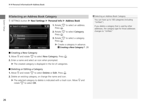 27
27 28
28 29
29 30
30 31
31 32
32 33
33 34
34 35
35 36
36 37
37 38
38 39
39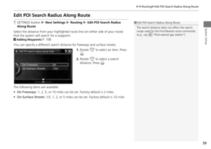 40
40 41
41 42
42 43
43 44
44 45
45 46
46 47
47 48
48 49
49 50
50 51
51 52
52 53
53 54
54 55
55 56
56 57
57 58
58 59
59 60
60 61
61 62
62 63
63 64
64 65
65 66
66 67
67 68
68 69
69 70
70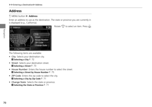 71
71 72
72 73
73 74
74 75
75 76
76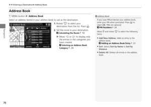 77
77 78
78 79
79 80
80 81
81 82
82 83
83 84
84 85
85 86
86 87
87 88
88 89
89 90
90 91
91 92
92 93
93 94
94 95
95 96
96 97
97 98
98 99
99 100
100 101
101 102
102 103
103 104
104 105
105 106
106 107
107 108
108 109
109 110
110 111
111 112
112 113
113 114
114 115
115 116
116 117
117 118
118 119
119 120
120 121
121 122
122 123
123 124
124 125
125 126
126 127
127 128
128 129
129 130
130 131
131 132
132 133
133 134
134 135
135 136
136 137
137 138
138 139
139 140
140 141
141 142
142 143
143 144
144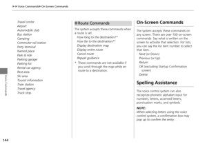 145
145 146
146 147
147 148
148 149
149 150
150 151
151
