2014 Acura ILX phone
[x] Cancel search: phonePage 190 of 234

189
Information FunctionsMap Update Status
Other Features
Map Update Status
HINFO button Map Update Status
Check the map data update status when updating the map database.
Roadside Assistance
H INFO button Other Roadside Assistance
Acura Roadside Assistance is provided as a service to Acura clients. Use this feature
to call for assistance when a Bluetooth-compatible phone is paired to Bluetooth®
HandsFreeLink®.
Rotate i to select Call. Press u to
begin dialing.
1 Map Update Status
This operation is only av ailable during a database
update.
2 Obtaining a Navigation Update P. 211
1Roadside Assistance
Your Bluetooth -compatible phone must be
paired to use this feature.
2 Pairing a Phone P. 164
Page 195 of 234

194
Troubleshooting
Troubleshooting
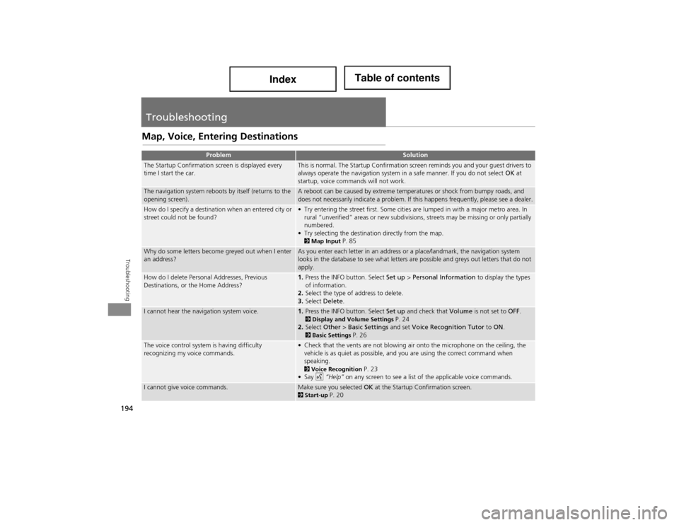
Map, Voice, Entering Destinations
ProblemSolution
The Startup Confirmation screen is displayed every
time I start the car.This is normal. The Startup Confirmation screen reminds you and your guest drivers to
always operate the navigation system in a safe manner. If you do not select OK at
startup, voice commands will not work.
The navigation system reboots by itself (returns to the
opening screen).A reboot can be caused by extreme temperatures or shock from bumpy roads, and
does not necessarily indicate a problem. If this happens frequently, please see a dealer.
How do I specify a destination when an entered city or
street could not be found?• Try entering the street first. Some cities are lumped in with a major metro area. In rural “unverified” areas or ne w subdivisions, streets may be missing or only partially
numbered.
• Try selecting the destination directly from the map.
2 Map Input P. 85
Why do some letters become greyed out when I enter
an address?As you enter each letter in an address or a place/landmark, the navigation system
looks in the database to see what letters are possible and greys out letters that do not
apply.
How do I delete Personal Addresses, Previous
Destinations, or the Home Address?1. Press the INFO button. Select Set up > Personal Information to display the types
of information.
2. Select the type of address to delete.
3. Select Delete .
I cannot hear the navigation system voice.1.Press the INFO button. Select Set up and check that Volume is not set to OFF. 2Display and Volu me Settings P. 24
2. Select Other > Basic Settings and set Voice Recognition Tutor to ON .
2Basic Settings P. 26
The voice control system is having difficulty
recognizing my voice commands.• Check that the vents are not blowing air onto the microphone on the ceiling, the
vehicle is as quiet as possible, and you are using the correct command when
speaking.
2 Voice Recognition P. 23
•Say d “Help” on any screen to see a list of the applicable voice commands.
I cannot give voice commands.Make sure you selected OK at the Startup Confirmation screen.2Start-up P. 20
Page 196 of 234

195
TroubleshootingMap, Voice, Entering Destinations
Troubleshooting
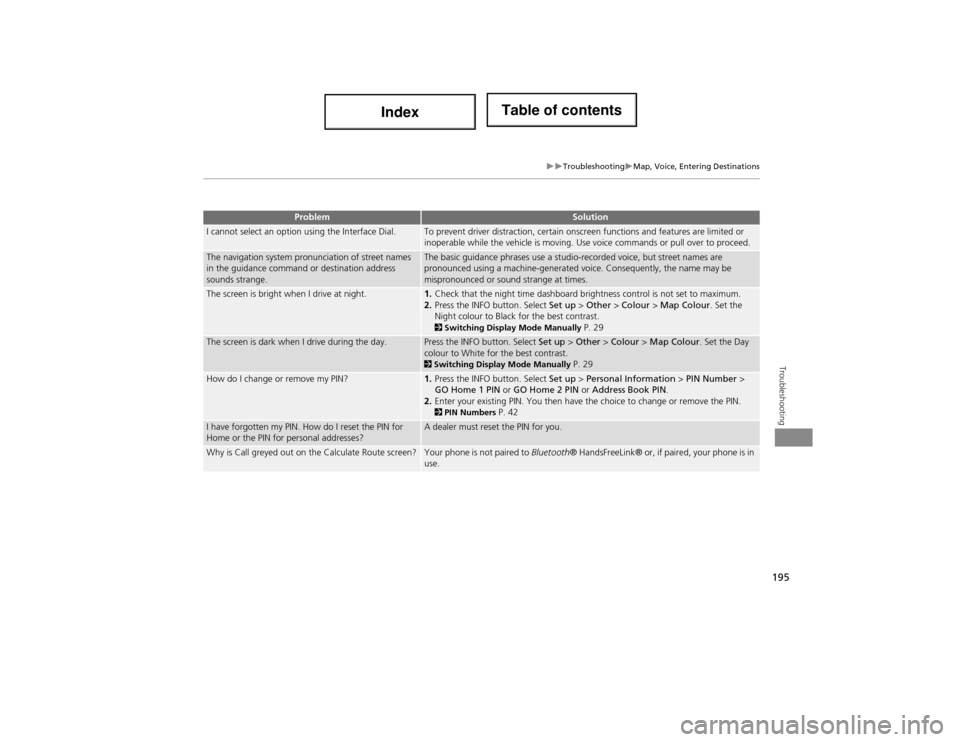
I cannot select an option using the Interface Dial.To prevent driver distraction, certain onscreen functions and features are limited or
inoperable while the vehicle is moving. Use voice commands or pull over to proceed.
The navigation system pronunciation of street names
in the guidance command or destination address
sounds strange.The basic guidance phrases use a studio-recorded voice, but street names are
pronounced using a machine-generated voice. Consequently, the name may be
mispronounced or sound strange at times.
The screen is bright when I drive at night.1.Check that the night time dashboard brightness control is not set to maximum.
2. Press the INFO button. Select Set up > Other > Colour > Map Colour . Set the
Night colour to Black for the best contrast.
2 Switching Display Mode Manually P. 29
The screen is dark when I drive during the day.Press the INFO button. Select Set up > Other > Colour > Map Colour . Set the Day
colour to White for the best contrast.
2 Switching Display Mode Manually P. 29
How do I change or remove my PIN?1. Press the INFO button. Select Set up > Personal Information > PIN Number >
GO Home 1 PIN or GO Home 2 PIN or Address Book PIN .
2. Enter your existing PIN. You then have the choice to change or remove the PIN.
2PIN Numbers P. 42
I have forgotten my PIN. How do I reset the PIN for
Home or the PIN for personal addresses?A dealer must reset the PIN for you.
Why is Call greyed out on the Calculate Route screen?Your phone is not paired to Bluetooth ® HandsFreeLink® or, if paired, your phone is in
use.
ProblemSolution
Page 197 of 234

196
TroubleshootingGuidance, Routing
Troubleshooting
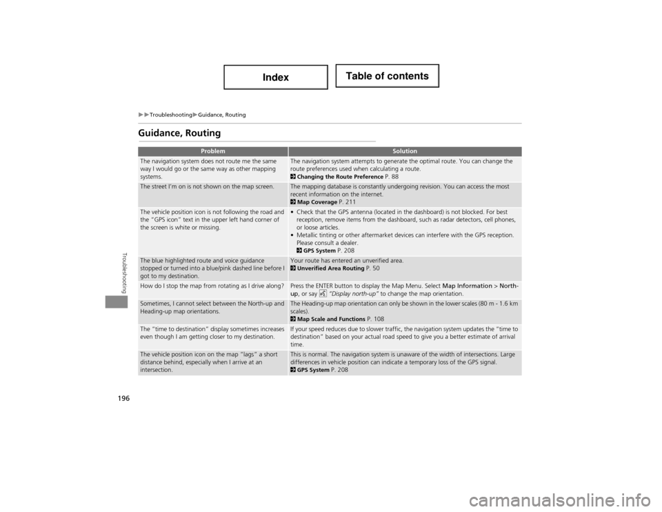
Guidance, Routing
ProblemSolution
The navigation system does not route me the same
way I would go or the same way as other mapping
systems.The navigation system attempts to generate the optimal route. You can change the
route preferences used when calculating a route.
2Changing the Route Preference P. 88
The street I’m on is not shown on the map screen.The mapping database is constantly undergoing revision. You can access the most
recent information on the internet.
2Map Coverage P. 211
The vehicle position icon is not following the road and
the “GPS icon” text in the upper left hand corner of
the screen is white or missing.• Check that the GPS antenna (located in the dashboard) is not blocked. For best
reception, remove items from the dashboard, such as radar detectors, cell phones,
or loose articles.
• Metallic tinting or other aftermarket devi ces can interfere with the GPS reception.
Please consult a dealer.
2 GPS System P. 208
The blue highlighted route and voice guidance
stopped or turned into a blue/pink dashed line before I
got to my destination.Your route has entered an unverified area. 2Unverified Area Routing P. 50
How do I stop the map from rotating as I drive along?Press the ENTER button to display the Map Menu. Select Map Information > North-
up, or say d “Display north-up” to change the map orientation.
Sometimes, I cannot select between the North-up and
Heading-up map orientations.The Heading-up map orientation can only be shown in the lower scales (80 m - 1.6 km
scales).
2Map Scale and Functions P. 108
The “time to destination” display sometimes increases
even though I am getting closer to my destination.If your speed reduces due to slower traffic, the navigation system updates the “time to
destination” based on your actual road speed to give you a better estimate of arrival
time.
The vehicle position icon on the map “lags” a short
distance behind, especially when I arrive at an
intersection.This is normal. The navigation system is unaware of the width of intersections. Large
differences in vehicle position can indica te a temporary loss of the GPS signal.
2GPS System P. 208
Page 209 of 234

208
Reference Information
System Limitations
GPS System
The signals received from the GPS satellites
are extremely weak (less than a millionth
of the strength of a local FM station) and
require an unobstructed view of the sky.
The GPS antenna is located in the
dashboard. The signal reception can easily
be interrupted or interfered with by the
following:
• Metallic window tint on the front or side
windows
• Cell phones, PDAs, or other electronic
devices docked in a cradle or lying loose
on the dashboard
• Remote starters or “hidden” vehicle
tracking systems mounted near the
navigation unit
• Audio electronic devi ces mounted near
the navigation unit
• Trees, tall buildings, highway
overpasses, tunnels, or overhead
electrical power wires
The GPS is operated by the U.S.
Department of Defense. For security
reasons, there are certain inaccuracies built
into the GPS for which the navigation
system must constantly compensate. This can cause occasional positioning errors of
up to several hundred feet.Address Calculation
The destination icon shows only the
approximate location of a destination
address. This occurs if the number of
possible addresses is different from the
number of actual addresses on a block. For
example, the addres
s 1425 on a 1400
block with 100 possible addresses
(because it is followed by the 1500 block)
will be shown a quarter of the way down
the block by the system. If there are only
25 actual addresses on the block, the
actual location of address 1425 would be
at the end of the block.
Database
The digitised map database reflects
conditions as they existed at various points
in time before production. Accordingly,
your database may contain inaccurate or
incomplete data or information due to the
passage of time, road construction,
changing conditions, or other causes.
For example, some places/landmarks may
be missing when you search the database
because the name was misspelled, the
place was improperly categorised, or a
place/landmark is not yet in the database.
This is also true for police stations,
hospitals, and other public institutions. Do
not rely on the navigation system if you
need law enforcement or hospital services.
Always check with local information
sources.
Page 211 of 234

210
Reference Information
Client Assistance
Resolving Problems
If you run into a specific issue that you
cannot resolve, consult the following help
resources:
• For navigation system issues:
2 Troubleshooting P. 194
There are also FAQs available online at
www.acuranavi.ca.
• For questions regarding Bluetooth®
HandsFreeLink®:
2 Bluetooth ® HandsFreeLink® P. 162
• For reporting issues with the database
or places/landmarks:
2 Reporting Errors P. 210
• Call Acura Client Relations.
2 Acura Client Relations Contact
Information P. 210
Reporting Errors
You can help to improve database
accuracy by reporti ng any errors you
encounter.
• Report errors in highways and main
“verified” roads shown in black on the
map at http://mapreporter.navteq.com/
dur-web-external/ .
• Please do not report errors in purple
“unverified” roads. Maps for these
areas are provided for reference only.
2 Unverified Area Routing P. 50
• Please do not report errors in places/
landmarks, such as changes in business
names. Information about points of
interest are constantly being updated.
An updated database is available for
purchase, usually in the fall of each year.
2 Obtaining a Navigation Update P. 211
• For vehicle position icon errors, screen
error messages, or other GPS-related
errors:
2 Troubleshooting P. 1942System Limitations P. 208
Acura Client Relations
Contact Information
Acura Navi
Acura Client Relations
Honda Canada Inc.
Telephone: (888) 9-ACURA-9
8:00 am to 7:30 pm Monday to Friday
(Eastern time)
180 Honda Boulevard Markham, ON
L6C 0H9
E-Mail: [email protected]
Visiting a Dealer
If you have a question that you cannot
resolve using the availa ble help resources,
you can consult a dealer. Please identify
the specific issue (e.g ., error occurs when
you enter a specific a ddress, when driving
on a certain road, or just when it’s cold) so
that the service technician can refer the
issue to the factory so that a solution can
be found. Be patient, the service technician
may be unfamiliar with your specific issue.
Page 218 of 234

217
Voice Commands
Voice Commands.................................. 218
Global Commands ............................... 218
Navigation Commands ......................... 218
Climate Control Commands ................. 220
Audio Commands ................................ 221
Cellular Phone Commands ................... 224
Main Setup Screen Commands ............ 224
On-Screen Commands ......................... 225
Spelling Assistance ........ ....................... 225
Page 219 of 234

218
Voice Commands
Voice Commands
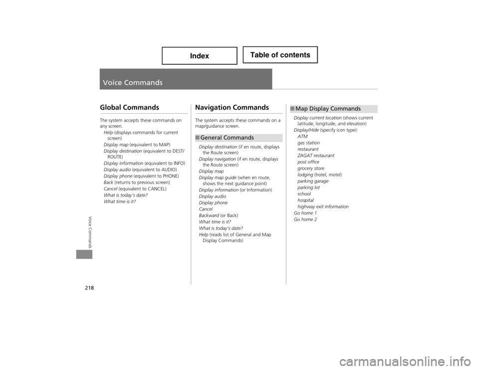
Global Commands
The system accepts these commands on
any screen.Help (displays commands for current
screen)
Display map (equivalent to MAP)
Display destination (equivalent to DEST/
ROUTE)
Display information (equivalent to INFO)
Display audio (equivalent to AUDIO)
Display phone (equivalent to PHONE)
Back (returns to previous screen)
Cancel (equivalent to CANCEL)
What is today’s date?
What time is it?
Navigation Commands
The system accepts these commands on a
map/guidance screen.
Display destination (if en route, displays
the Route screen)
Display navigation (if en route, displays
the Route screen)
Display map
Display map guide (when en route,
shows the next guidance point)
Display information (or Information)
Display audio
Display phone
Cancel
Backward (or Back)
What time is it?
What is today’s date?
Help (reads list of General and Map
Display Commands)
■ General Commands
Display current location (shows current
latitude, longitude, and elevation)
Display/Hide (specify icon type):
ATM
gas station
restaurant
ZAGAT restaurant
post office
grocery store
lodging (hotel, motel)
parking garage
parking lot
school
hospital
highway exit information
Go home 1
Go home 2
■ Map Display Commands