2014.5 VAUXHALL CORSA change time
[x] Cancel search: change timePage 11 of 177
Introduction11
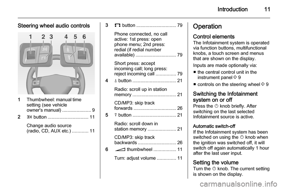
Steering wheel audio controls
1Thumbwheel: manual time
setting (see vehicle
owner's manual) ...................... 9
2 q button ............................... 11
Change audio source
(radio, CD, AUX etc.) ............11
3p button .............................. 79
Phone connected, no call
active: 1st press: open
phone menu; 2nd press:
redial (if redial number
available) ............................... 79
Short press: accept
incoming call; long press:
reject incoming call ...............79
4 d button ................................. 21
Radio: scroll up in station
memory ................................. 21
CD/MP3: skip track
forwards ................................ 26
5 c button ................................. 21
Radio: scroll down in
station memory .....................21
CD/MP3: skip track
backwards ............................. 26
6 o thumbwheel .................11
Turn: adjust volume ..............11Operation
Control elements The Infotainment system is operated
via function buttons, multifunctional
knobs, a touch screen and menus
that are shown on the display.
Inputs are made optionally via: ■ the central control unit in the instrument panel 3 9
■ controls on the steering wheel 3 9
Switching the Infotainment
system on or off
Press the X knob briefly. After
switching on the last selected
Infotainment source is active.
Automatic switch-off
If the Infotainment system has been
switched on using the X knob when
the ignition was switched off, it will
switch off again automatically 1 hour
after the last user input.
Setting the volume Turn the X knob. The current setting
is shown on the display.
Page 20 of 177

20RadioRadioUsage.......................................... 20
Station search .............................. 21
Radio data system (RDS) ............22Usage
Notice
Within the radio menus you can only use the touch screen to select/
activate the screen buttons at the
bottom of the menus.
Activating the radio Press the FM-AM button to open the
radio main menu.
The station last played will be
received.
If the currently played station is an
RDS station 3 22, the station name
and programme related information
are displayed.
Selecting the waveband Press the FM-AM button once or
several times to select the desired
waveband.
The station last played in that
waveband will be received.
If the waveband is changed from
FM1 to FM2 or vice versa, the
currently received station will remain
active.
If the currently received station is
stored on one of the station buttons
1...6, the corresponding button
number, e.g. P3, is displayed beside
the waveband name in the top line of
the menu.
Notice
There are two FM waveband menus
available to enable you to store 12
FM stations on the station buttons 1...6.
Page 22 of 177

22Radio
The list entry of the currently played
FM station is highlighted in red.
If a station is stored on one of the
station buttons 1...6, the
corresponding waveband name and
the button number are displayed in
the list, e.g. FM1-P3.
Select the list entry of the FM station
to be played.
Notice
The dual tuner of the Infotainment
system continuously updates the FM
station list in the background.
This ensures that, e.g., the station
list always contains the FM stations
that can be received in the local area during a long motorway journey.
As the automatic updating takes a certain amount of time, not all
stations that can be received may be
available at once in the station list at a sudden change in reception area.
Station buttons 1...6
In each waveband (AM, FM1 and
FM2) six radio stations can be stored
on the station buttons 1...6.
Storing a station 1. Select the desired waveband.
2. Tune to the desired station or select it from the FM station list.
3. Press and hold one of the station buttons until you hear a beep.
The corresponding button
number, e.g. P3, is displayed
beside the waveband name in the
top line of the menu.
The currently received radio station is stored and can be retrieved via the
station button in future.Notice
If no beep can be heard when storing
a station, system sounds are
deactivated. Activation of system
sounds 3 11.
Retrieving a station
Select the desired waveband and
then briefly press a station button to
retrieve the corresponding radio
station.
Radio data system (RDS) The RDS is a system through which
encoded digital information is
transmitted in addition to the normal
FM radio broadcasts. The RDS
provides information services such as station name, traffic information and
radio text.
RDS Regional mode At certain times some RDS stations
broadcast regionally different
programmes on different frequencies.
The Infotainment system always
tunes into the best receivable
frequency of the currently played RDS station.
Page 23 of 177
Radio23
If RDS Regional mode is activated,
only frequencies of the currently
received RDS station with the same
regional programme are considered.
If RDS Regional mode is deactivated,
also frequencies of the currently
received RDS station with different
regional programmes are considered.
Activating or deactivating
RDS Regional mode
Press the SETUP button and then
select the Radio settings screen
button.
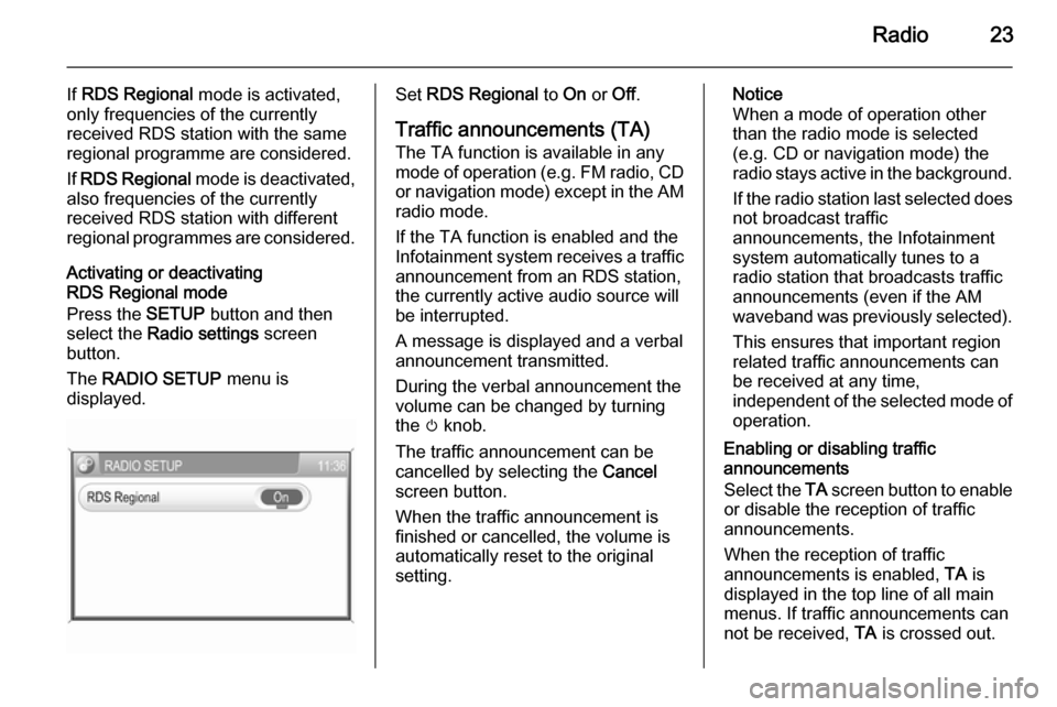
The RADIO SETUP menu is
displayed.Set RDS Regional to On or Off.
Traffic announcements (TA)
The TA function is available in any
mode of operation ( e.g. FM radio, CD
or navigation mode) except in the AM
radio mode.
If the TA function is enabled and the
Infotainment system receives a traffic announcement from an RDS station,
the currently active audio source will
be interrupted.
A message is displayed and a verbal
announcement transmitted.
During the verbal announcement the
volume can be changed by turning
the m knob.
The traffic announcement can be
cancelled by selecting the Cancel
screen button.
When the traffic announcement is
finished or cancelled, the volume is
automatically reset to the original
setting.Notice
When a mode of operation other
than the radio mode is selected
(e.g. CD or navigation mode) the
radio stays active in the background.
If the radio station last selected does
not broadcast traffic
announcements, the Infotainment
system automatically tunes to a
radio station that broadcasts traffic
announcements (even if the AM
waveband was previously selected).
This ensures that important region
related traffic announcements can
be received at any time,
independent of the selected mode of operation.
Enabling or disabling traffic
announcements
Select the TA screen button to enable
or disable the reception of traffic
announcements.
When the reception of traffic
announcements is enabled, TA is
displayed in the top line of all main
menus. If traffic announcements can
not be received, TA is crossed out.
Page 39 of 177
Navigation39
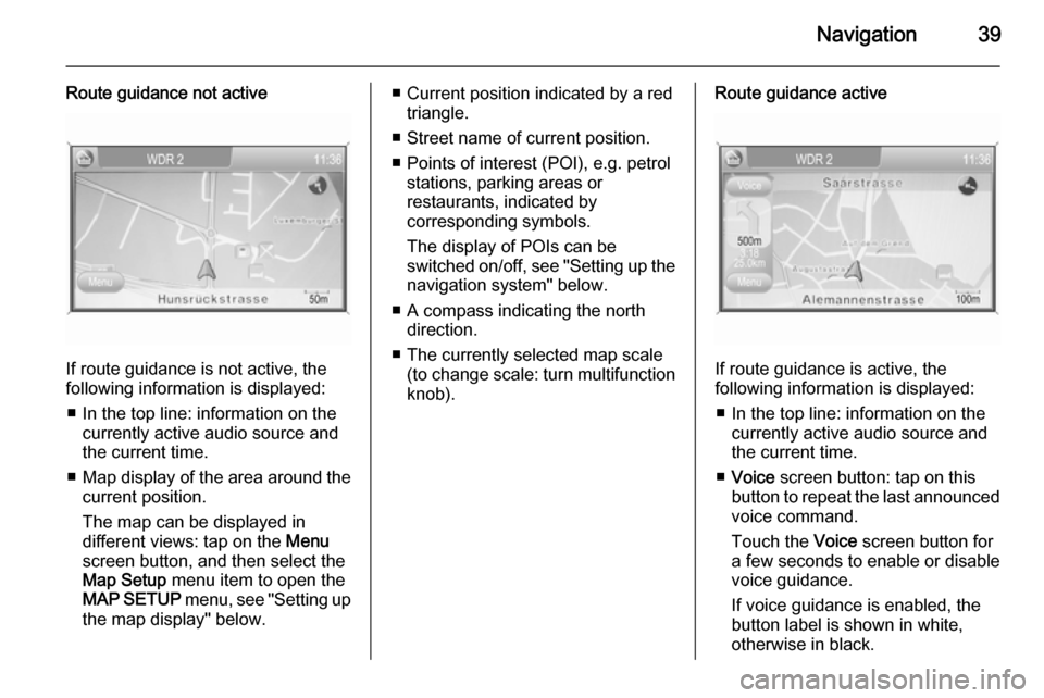
Route guidance not active
If route guidance is not active, the
following information is displayed:
■ In the top line: information on the currently active audio source and
the current time.
■ Map display of the area around the
current position.
The map can be displayed in
different views: tap on the Menu
screen button, and then select the
Map Setup menu item to open the
MAP SETUP menu, see "Setting up
the map display" below.
■ Current position indicated by a red triangle.
■ Street name of current position.
■ Points of interest (POI), e.g. petrol stations, parking areas or
restaurants, indicated by
corresponding symbols.
The display of POIs can be
switched on/off, see "Setting up the
navigation system" below.
■ A compass indicating the north direction.
■ The currently selected map scale (to change scale: turn multifunctionknob).Route guidance active
If route guidance is active, the
following information is displayed:
■ In the top line: information on the currently active audio source and
the current time.
■ Voice screen button: tap on this
button to repeat the last announced
voice command.
Touch the Voice screen button for
a few seconds to enable or disable
voice guidance.
If voice guidance is enabled, the button label is shown in white,
otherwise in black.
Page 40 of 177

40Navigation
Notice
The activation/deactivation of voice
guidance is indicated by a beep, if
system sounds are activated 3 11.
■ Map display of the area around the
current position.
The map can be displayed in
different views: tap on the Menu
screen button and then select the
Map Setup menu item to open the
MAP SETUP menu, see "Setting up
the map display" below.
■ Current position indicated by a red triangle.
■ Route indicated by a blue line.
■ Final destination indicated by a black chequered flag.
■ Waypoint (intermediate destination) indicated by a red
chequered flag.
■ Points of interest (POI), e.g. petrol stations, parking areas, or
restaurants, indicated by
corresponding symbols, see
chapter "Symbol overview" 3 73.The display of POIs can be
switched on/off, see "Setting up the
map display" below.
■ Traffic incidents, e.g. traffic jams, indicated by corresponding
symbols, see chapter "Symbol
overview" 3 73.
Traffic incidents are only indicated
on the map display, if dynamic
route guidance is activated, see
chapter "Guidance" 3 65.
■ At the bottom of the map: street name of the current position.
■ At the top of the map: name of the street to follow after the next
intersection.
■ Direction arrow and distance to the
next manoeuvre.
Changing the distance unit, see
"Setting up the navigation system"
below.
■ Estimated arrival time or remaining
travel time.
To toggle between arrival time and
remaining travel time: tap on the
displayed time.■ Remaining distance to the final destination.
Changing the distance unit, see
"Setting up the navigation system"
below.
■ A compass symbol indicating the north direction.
If the two-dimensional map view
mode is active (see "Setting up the
map display" below): tap on the
compass symbol to toggle the map
view between the "north
orientation" and the "driving
direction orientation" mode.
■ The currently selected map scale (to change scale: turn multifunction
knob).
If the auto zoom mode is active (see "Setting up the map display"
below): the map scale will be
adjusted (zoom in/out)
automatically by the navigation system to ensure reliable route
guidance.
Page 67 of 177
Navigation67
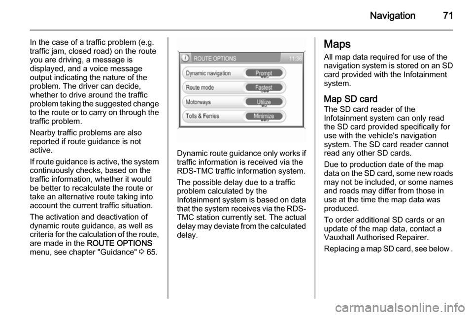
Automatic: all TMC messages are
automatically taken into account for
route calculation/recalculation.
Prompt : in the event of a traffic jam
or other traffic incidents, for which
the navigation system receives a
TMC message, you will be
prompted by a message:
if an alternative route to the
destination should be calculated
or
if the previously calculated route
should remain unchanged.
The messages will be shown on the display even if an audio mode (e.g.
AM/FM or CD) or the telephone
mode are currently active.
■ Route mode : select, if the fastest,
the most economical, or the
shortest route should be calculated for route guidance.
■ Motorways : select, if motorways
should be avoided or utilised for
route guidance.
■ Tolls & Ferries : select, if toll roads
and ferries should be avoided or
utilised, or, if the use of toll roadsand ferries should be minimized,
when calculating the route to the
destination.
Displaying the route list
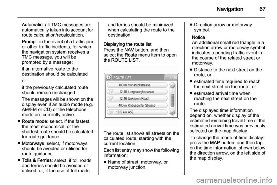
Press the NAV button, and then
select the Route menu item to open
the ROUTE LIST .
The route list shows all streets on the
calculated route, starting with the
current location.
Each list entry may show the following
information:
■ Name of street, motorway, or motorway junction.
■ Direction arrow or motorwaysymbol.
Notice
An additional small red triangle in a
direction arrow or motorway symbol
indicates a pending traffic event in
the course of the related street or
motorway.
■ Distance to the next street on the route, or
■ estimated time required to reach the next street on the route, or
■ estimated arrival time when reaching the next street on the
route.
The displayed time information
depend on, whether display of the
estimated remaining travel time or the estimated arrival time was previously
selected on the map display.
To change the mode of time display:
press the MAP button, and then tap
on the time information, shown below the direction arrow, on the left side of
the map display.
Page 71 of 177
Navigation71
In the case of a traffic problem (e.g.
traffic jam, closed road) on the route
you are driving, a message is
displayed, and a voice message
output indicating the nature of the
problem. The driver can decide,
whether to drive around the traffic
problem taking the suggested change
to the route or to carry on through the traffic problem.
Nearby traffic problems are also
reported if route guidance is not
active.
If route guidance is active, the system
continuously checks, based on the
traffic information, whether it would
be better to recalculate the route or
take an alternative route taking into
account the current traffic situation.
The activation and deactivation of
dynamic route guidance, as well as
criteria for the calculation of the route,
are made in the ROUTE OPTIONS
menu, see chapter "Guidance" 3 65.
Dynamic route guidance only works if
traffic information is received via the
RDS-TMC traffic information system.
The possible delay due to a traffic
problem calculated by the
Infotainment system is based on data
that the system receives via the RDS- TMC station currently set. The actual
delay may deviate from the calculated delay.
Maps
All map data required for use of the
navigation system is stored on an SD
card provided with the Infotainment
system.
Map SD card The SD card reader of the
Infotainment system can only read
the SD card provided specifically for
use with the vehicle's navigation
system. The SD card reader cannot
read any other SD cards.
Due to production date of the map
data on the SD card, some new roads
may not be included, or some names and roads may differ from those in
use at the time the map data was produced.
To order additional SD cards or an
update of the map data, contact a
Vauxhall Authorised Repairer.
Replacing a map SD card, see below .