Page 88 of 275

3-32Navigation
stored.
SETTING BY PHONE NUMBER
If the phone number of a facility is known, it is
possible to search for a facility by entering the
phone number, and have the system calculate a
route.
INFO:
. If the area code of the specified telephone
number does not exist in the map data, the
system cannot search for the location.
. Only the locations included in the database
in the map data can be searched by the
phone number. Residential phone numbers
cannot be used to search for a location.
1. Push the MENUbutton and touch [Destina-
tion].
2. Touch [Next Page].
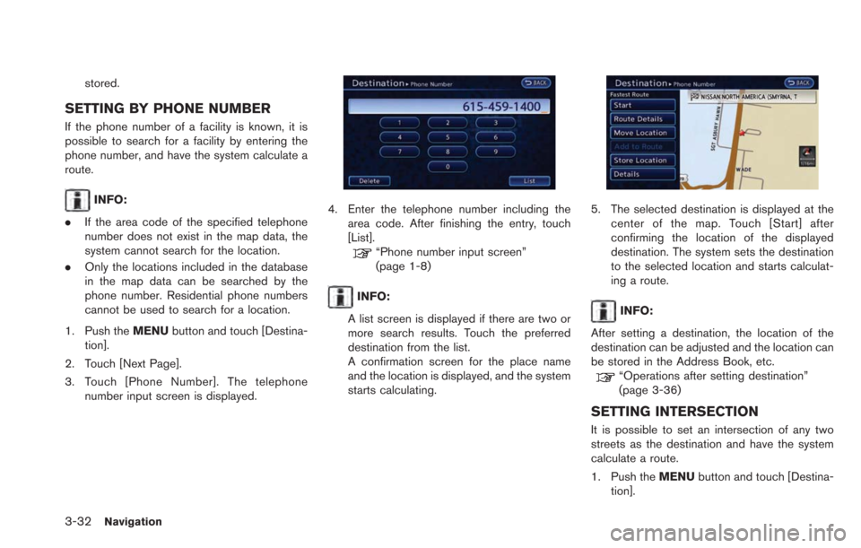
3. Touch [Phone Number]. The telephone number input screen is displayed.4. Enter the telephone number including thearea code. After finishing the entry, touch
[List].
“Phone number input screen”
(page 1-8)
INFO:
A list screen is displayed if there are two or
more search results. Touch the preferred
destination from the list.
A confirmation screen for the place name
and the location is displayed, and the system
starts calculating.
5. The selected destination is displayed at the center of the map. Touch [Start] after
confirming the location of the displayed
destination. The system sets the destination
to the selected location and starts calculat-
ing a route.
INFO:
After setting a destination, the location of the
destination can be adjusted and the location can
be stored in the Address Book, etc.
“Operations after setting destination”
(page 3-36)
SETTING INTERSECTION
It is possible to set an intersection of any two
streets as the destination and have the system
calculate a route.
1. Push the MENUbutton and touch [Destina-
tion].
Page 89 of 275
2. Touch [Next Page].
3. Touch [Intersection].
4. Touch [1st Street]. A character input screenis displayed.
INFO:
Touch [Region] or [City] to narrow down the
specified region and city.
5. Enter the name of the 1st street. After finishing the entry, touch [List]. A list screen
is displayed.
6. Touch a street as the 1st street from the list.
7. Touch [2nd Street.]. A character inputscreen is displayed.
8. Enter the name of the 2nd street. Afterfinishing the entry, touch [List]. A list screen
is displayed.
9. Touch a street as the 2nd street from the list.
10. Touch [OK].
Navigation3-33
Page 90 of 275
![NISSAN LEAF 2013 1.G Navigation Manual 3-34Navigation
11. The select destination is displayed at thecenter of the map. Touch [Start] after
confirming the location of the displayed
destination. The system sets the selected
location as the d NISSAN LEAF 2013 1.G Navigation Manual 3-34Navigation
11. The select destination is displayed at thecenter of the map. Touch [Start] after
confirming the location of the displayed
destination. The system sets the selected
location as the d](/manual-img/5/324/w960_324-89.png)
3-34Navigation
11. The select destination is displayed at thecenter of the map. Touch [Start] after
confirming the location of the displayed
destination. The system sets the selected
location as the destination and starts calcu-
lating a route.
INFO:
After setting a destination, the location of the
destination can be adjusted and the location can
be stored in the Address Book, etc.
“Operations after setting destination”
(page 3-36)
SETTING CITY CENTER
It is possible to set the center of a city as a
destination and have the system calculate a
route.
1. Push the MENUbutton and touch [Destina-
tion]. 2. Touch [Next Page].
3. Touch [City Center]. A character input
screen is displayed.
4. Enter the name of the city, touch [List]. A listscreen is displayed.
INFO:
Touch [Last 5 Cities] to display the last 5
cities recently set as destinations.
5. Touch the preferred destination from the list.
INFO:
Select [By Distance] to sort the list by the
nearest distance.
6. The selected destination is displayed at the center of the map. Touch [Start] after
confirming the location of the displayed
destination. The system sets the destination
to the selected location and starts calculat-
ing a route.
INFO:
After setting a destination, the location of the
destination can be adjusted, the location
can be stored in the Address Book, etc.
“Operations after setting destination”
(page 3-36)
Page 91 of 275
SETTING FREEWAY ENTRANCE/
EXIT
It is possible to set the destination to an
entrance or exit of a freeway and have the
system calculate a route.
1. Push theMENUbutton and touch [Destina-
tion].
2. Touch [Next Page].
3. Touch [Freeway Entrance/Exit]. A character input screen is displayed.
4. Enter the name of the freeway. After finishingthe entry, touch [List].
5. Touch the freeway of the destination fromthe list.
6. Touch [Entrance] or [Exit]. A list screen isdisplayed.
7. Select the preferred destination from the list.The position of the selected location is
displayed in the preview on the right side
of the screen.
INFO:
Select [By Distance] to sort the list by the
nearest distance.
8. The selected destination is displayed at the center of the map. Touch [Start] after
confirming the location of the displayed
Navigation3-35
Page 92 of 275

3-36Navigation
destination. The system sets the destination
to the selected location and starts calculat-
ing a route.
INFO:
After setting a destination, the location of the
destination can be adjusted and the location can
be stored in the Address Book, etc.
“Operations after setting destination”
(page 3-36)
SETTING POINT ON MAP
It is possible to set a location scrolled to on the
map as the destination and have the system
calculate a route.
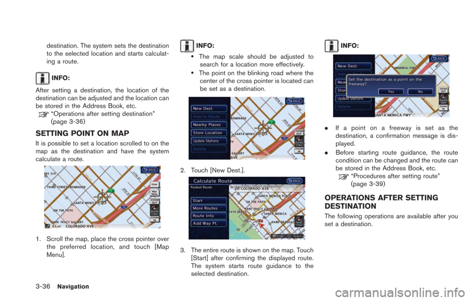
1. Scroll the map, place the cross pointer over the preferred location, and touch [Map
Menu].
INFO:
.The map scale should be adjusted tosearch for a location more effectively.
.The point on the blinking road where thecenter of the cross pointer is located can
be set as a destination.
2. Touch [New Dest.].
3. The entire route is shown on the map. Touch [Start] after confirming the displayed route.
The system starts route guidance to the
selected destination.
INFO:
.If a point on a freeway is set as the
destination, a confirmation message is dis-
played.
. Before starting route guidance, the route
condition can be changed and the route can
be stored in the Address Book, etc.
“Procedures after setting route”
(page 3-39)
OPERATIONS AFTER SETTING
DESTINATION
The following operations are available after you
set a destination.
Page 93 of 275
![NISSAN LEAF 2013 1.G Navigation Manual Available items after setting destination
.[Start]:
Starts route guidance to the selected
destination.
“Starting route guidance” (page 3-37)
. [Route Details]:
Allows you to change the route searc NISSAN LEAF 2013 1.G Navigation Manual Available items after setting destination
.[Start]:
Starts route guidance to the selected
destination.
“Starting route guidance” (page 3-37)
. [Route Details]:
Allows you to change the route searc](/manual-img/5/324/w960_324-92.png)
Available items after setting destination
.[Start]:
Starts route guidance to the selected
destination.
“Starting route guidance” (page 3-37)
. [Route Details]:
Allows you to change the route search
conditions or to check the route information.
“Procedures after setting route”
(page 3-39)
. [Move Location]:
Displays a map screen. The location of the
destination can be adjusted.
“Moving location of destination”
(page 3-37)
. [Add to Route]:
Edits the route by adding a waypoint or a
destination.
“Adding additional destinations to a
route” (page 3-37) .
[Store Location]:
Stores the location in the Address Book.
“Storing location” (page 3-38)
. [Details]:
Displays information about the facility that
has been set as the destination, if it is
included in the map data.
“Viewing information about searched
location” (page 3-38)
Starting route guidance
1. Touch [Start]. Route guidance starts. If the
route is already set, the location becomes
the new destination, and the route is
recalculated.
Moving location of destination
The location of the destination can be adjusted
by moving the cross pointer across the map.
1. Touch [Move Location]. A map screen withthe destination located on the map center is
displayed.
2. Adjust the location by moving the cross pointer across the map and touch [OK]. The
location of the destination is modified.
INFO:
. The screen for adjusting the location also
changes when the map screen displayed on
the right side of the screen is touched.
. The map scale can be changed by touching
[ZOOM OUT] or [ZOOM IN].
Adding additional destinations to a
route
Even after the route is already set, you can add a
searched location as a new destination or
waypoint to that route.
If the route has not been set, [Add to Route]
Navigation3-37
Page 94 of 275
![NISSAN LEAF 2013 1.G Navigation Manual 3-38Navigation
cannot be selected.
1. Touch [Add to Route].
2. Touch [Add Destination] or [Add Waypoint].The system starts calculating a route that
includes the added destination or waypoint.
When the NISSAN LEAF 2013 1.G Navigation Manual 3-38Navigation
cannot be selected.
1. Touch [Add to Route].
2. Touch [Add Destination] or [Add Waypoint].The system starts calculating a route that
includes the added destination or waypoint.
When the](/manual-img/5/324/w960_324-93.png)
3-38Navigation
cannot be selected.
1. Touch [Add to Route].
2. Touch [Add Destination] or [Add Waypoint].The system starts calculating a route that
includes the added destination or waypoint.
When the calculation is finished, the route is
displayed.
Storing location
A searched location can be stored in the
Address Book. Then it can be easily retrieved
and set as a destination (or waypoint).
1. Touch [Store Location]. A message isdisplayed, the location is stored in the
Address Book. The corresponding icon is
displayed at the set location on the map.
Viewing information about searched
location
Information (street address and phone number)
about points of interest stored in the map data
can be displayed.
1. Touch [Details]. Information about the loca-
tion is displayed.
2. Touch the item you would like to set. Available settings
.[Show Map]:Returns to the previous screen.
.[Call]:
Makes a call to the selected charging
station. A cellular phone needs to be
connected beforehand.
“Connecting cellular phone”
(page 1-13)
.[Details]:This appears only when a charging
station is set as a destination. Displays
detailed information including the type
and number of charging devices existing
at the selected charging station.
INFO:
Information about locations is not displayed
while driving.
Page 95 of 275
![NISSAN LEAF 2013 1.G Navigation Manual PROCEDURES AFTER SETTING
ROUTE
After performing a route search, route guidance
can be started. Also, it is possible to confirm or
change a route.
1. Touch [Route Details].
2. Touch the item you would NISSAN LEAF 2013 1.G Navigation Manual PROCEDURES AFTER SETTING
ROUTE
After performing a route search, route guidance
can be started. Also, it is possible to confirm or
change a route.
1. Touch [Route Details].
2. Touch the item you would](/manual-img/5/324/w960_324-94.png)
PROCEDURES AFTER SETTING
ROUTE
After performing a route search, route guidance
can be started. Also, it is possible to confirm or
change a route.
1. Touch [Route Details].
2. Touch the item you would like to set.
Available items after setting route
.[Start]:
Starts route guidance to the selected
destination.
“Starting route guidance” (page 3-39)
. [More Routes]:
Displays 3 alternative routes.
“Changing route condition”
(page 3-39)
. [Route Info]:
Displays the route information. A calculated
route can also be stored in the Address Book.
“Confirming route” (page 3-40)
. [Add Way Pt.]:
Allows you to edit the route by adding a
destination or waypoint.
“Adding destination or waypoint”
(page 3-41)
Starting route guidance
1. Touch [Start]. Route guidance starts.
INFO:
If no operations have been performed on the
system for several seconds, [Start] is automati-
cally selected, and the system starts route
guidance. When the vehicle is being driven,
[Start] is automatically selected and the system
will start the route guidance function.
Changing route condition
1. Touch [More Routes].
2. Touch the preferred route condition. When the route is selected, a preview is displayed
on the right side of the screen. After
selecting the route condition, touch [OK].
Available route conditions
.[ECO] (green):
Prioritizes the least amount of electrical
consumption.
.[Short. Time] (purple):Prioritizes the shortest time.
.[Min. Freeway] (orange):Minimizes the use of freeways.
.[Short. Dist.] (pink):Prioritizes the shortest distance.
Navigation3-39
ROUTE GUIDANCE