2013 NISSAN GT-R navigation system
[x] Cancel search: navigation systemPage 121 of 315
![NISSAN GT-R 2013 R35 Multi Function Display Owners Manual .[Map Icons]:
Set the map icons to display on the map.
“Displaying map icons” (page 2-17)
. [Guidance Settings]:
Set the various functions for the route
guidance.
“Guidance settings” (page 2-6 NISSAN GT-R 2013 R35 Multi Function Display Owners Manual .[Map Icons]:
Set the map icons to display on the map.
“Displaying map icons” (page 2-17)
. [Guidance Settings]:
Set the various functions for the route
guidance.
“Guidance settings” (page 2-6](/manual-img/5/316/w960_316-120.png)
.[Map Icons]:
Set the map icons to display on the map.
“Displaying map icons” (page 2-17)
. [Guidance Settings]:
Set the various functions for the route
guidance.
“Guidance settings” (page 2-62)
. [Route Settings]:
Change the routing preferences.
“Detailed route settings” (page 2-66)
. [Traffic Info Settings]:
Set the various functions of the XM Nav-
Traffic
®information system.“Traffic information settings”
(page 6-11)
. [Weather Info Setting]:
Set the functions of the XM NavWeather
TM
information system.“Weather information settings”
(page 6-20)
. [Speed Limit Info]:
Display speed limit information.
“Speed limit indication on map”
(page 2-93)
. [Others]:
Display other setting items.
“Other navigation settings”
(page 2-93) .
[Delete Stored Information]:
Delete stored locations and the home
setting in the Address Book.
“Delete stored items” (page 2-97)
. [Delete All Previous Destinations]:
Delete all previous destinations.
“Delete stored items” (page 2-97)
. [Delete Previous Starting Point]:
Delete all previous starting points.
“Delete stored items” (page 2-97)
. [Reset All Navigation Settings to Default]:
Reset all of the settings to default.
“Reset all navigation settings to de-
fault” (page 2-97)
SPEED LIMIT INDICATION ON MAP
Turn the [Speed Limit Info] display on or off. The
indicator light illuminates when the speed limit
display function is set to on.
1. Highlight [Speed Limit Info] and push
2. Highlight [Speed Limit Indication on Map] totoggle the function between on and off. The
indicator light illuminates when the speed
limit display function is set to on.
OTHER NAVIGATION SETTINGS
Basic Operation
Navigation2-93
Page 122 of 315
![NISSAN GT-R 2013 R35 Multi Function Display Owners Manual 2-94Navigation
1. Push<SETTING>.
2. Highlight [Navigation] and push <ENTER>.
3. Highlight [Others] and push <ENTER>.
4. Highlight the preferred setting item and push <ENTER>.
Available setting items
. NISSAN GT-R 2013 R35 Multi Function Display Owners Manual 2-94Navigation
1. Push<SETTING>.
2. Highlight [Navigation] and push <ENTER>.
3. Highlight [Others] and push <ENTER>.
4. Highlight the preferred setting item and push <ENTER>.
Available setting items
.](/manual-img/5/316/w960_316-121.png)
2-94Navigation
1. Push
2. Highlight [Navigation] and push
3. Highlight [Others] and push
4. Highlight the preferred setting item and push
Available setting items
. [Audio Display on Map]:
Allows the audio information to be displayed
at all times.
“Displaying audio information on map
screen” (page 2-94)
. [Small Step Zoom by Dial]:
Sets the free zoom function on or off. When
this setting is on, it is possible to adjust the
scale in smaller steps than with normal scale
adjustment.
. [Map Scrolling Information]:
Sets the system so that when the map
scrolls the information about the location
aligned at the center of the cross pointer is
displayed.
“Map scrolling information”
(page 2-18)
. [Customize Nearby Places]:
Set the category of frequently visited land-
marks.
“Customizing Nearby Places”
(page 2-94) .
[Keyboard Type]:
Switches the keyboard layout for the char-
acter input screen.
“Settings keyboard layout of character
input screen” (page 2-95)
. [North Up when Zoom Out]:
When this setting is ON, the orientation of
the map is automatically changed to North
Up when the widest map scale is selected.
The orientation is changed to North Up even
when Heading Up is set.
. [Adjust Current Location]:
Corrects the position of the current location.
“Adjusting current vehicle location”
(page 2-96)
Displaying audio information on
map screen
The operating status of audio functions can be
displayed on the map screen.
1. Highlight [Others] and push
2. Highlight [Audio Display on Map] and push
the item is set.
3. Push
Page 136 of 315
3-8Audio system
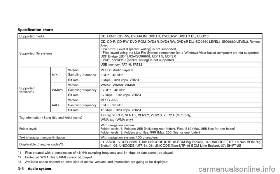
Specification chart:
Supported mediaCD, CD-R, CD-RW, DVD-ROM, DVD±R, DVD±RW, DVD±R DL, USB2.0
Supported file systems CD, CD-R, CD-RW, DVD-ROM, DVD±R, DVD±RW, DVD±R DL: ISO9660 LEVEL1, ISO9660 LEVEL2, Romeo,
Joliet
* ISO9660 Level 3 (packet writing) is not supported.
* Files saved using the Live File System component (on a Windows Vista-based computer) are not supported.
UDF Bridge (UDF1.02+ISO9660) , UDF1.5, UDF2.0
* VDF1.5/VDF2.0 (packet writing) is not supported.
USB memory: FAT16, FAT32
Supported
versions*1 MP3
Version
MPEG1 Audio Layer 3
Sampling frequency 8 kHz - 48 kHz
Bit rate 8 kbps - 320 kbps, VBR*4
WMA*2 Version
WMA7, WMA8, WMA9
Sampling frequency 32 kHz - 48 kHz
Bit rate 32 kbps - 192 kbps, VBR*4
AAC Version
MPEG-AAC
Sampling frequency 8 kHz - 96 kHz
Bit rate 16 kbps - 320 kbps, VBR*4
Tag information (Song title and Artist name) ID3 tag VER1.0, VER1.1, VER2.2, VER2.3, VER2.4 (MP3 only)
WMA tag (WMA only)
Folder levels With navigation system:
Folder levels: 8, Folders: 255 (including root folder) , Files: 512 (Max. 255 files for one folder)
Folder levels: 8, Folders and files: 999 (Max. 255 files for one folder)
Text character number limitation With navigation system: 100 characters
Displayable character codes*3 01: ASCII, 02: ISO-8859-1, 03: UNICODE (UTF-16 BOM Big Endian) , 04: UNICODE (UTF-16 Non-BOM Big
Endian) , 05: UNICODE (UTF-8) , 06: UNICODE (Non-UTF-16 BOM Little Endian) , 07: SHIFT-JIS
*1 Files created with a combination of 48 kHz sampling frequency and 64 kbps bit rate cannot be played.
*2 Protected WMA files (DRM) cannot be played.
*3 Available codes depend on what kind of media, versions and information are going to be displayed.
Page 179 of 315
6 Viewing technical information
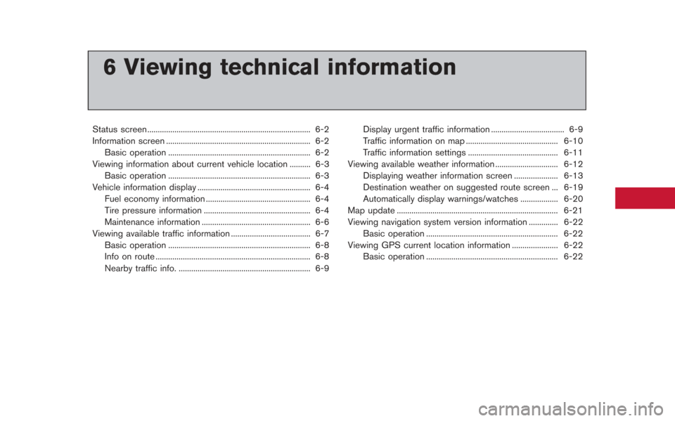
Status screen ........................................................................\
...... 6-2
Information screen ..................................................................... 6-2Basic operation .................................................................... 6-2
Viewing information about current vehicle location .......... 6-3 Basic operation .................................................................... 6-3
Vehicle information display ...................................................... 6-4
Fuel economy information .................................................. 6-4
Tire pressure information ................................................... 6-4
Maintenance information .................................................... 6-6
Viewing available traffic information ...................................... 6-7 Basic operation .................................................................... 6-8
Info on route ........................................................................\
.. 6-8
Nearby traffic info. ............................................................... 6-9 Display urgent traffic information ................................... 6-9
Traffic information on map ............................................ 6-10
Traffic information settings ........................................... 6-11
Viewing available weather information .............................. 6-12 Displaying weather information screen ..................... 6-13
Destination weather on suggested route screen ... 6-19
Automatically display warnings/watches .................. 6-20
Map update ........................................................................\
..... 6-21
Viewing navigation system version information .............. 6-22
Basic operation ............................................................... 6-22
Viewing GPS current location information ...................... 6-22 Basic operation ............................................................... 6-22
Page 180 of 315
6-2Viewing technical information
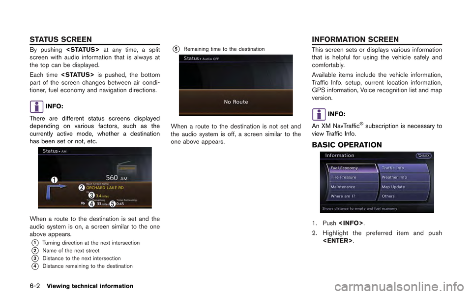
By pushing
screen with audio information that is always at
the top can be displayed.
Each time
part of the screen changes between air condi-
tioner, fuel economy and navigation directions.
INFO:
There are different status screens displayed
depending on various factors, such as the
currently active mode, whether a destination
has been set or not, etc.
When a route to the destination is set and the
audio system is on, a screen similar to the one
above appears.
*1Turning direction at the next intersection
*2Name of the next street
*3Distance to the next intersection
*4Distance remaining to the destination
*5Remaining time to the destination
When a route to the destination is not set and
the audio system is off, a screen similar to the
one above appears.
This screen sets or displays various information
that is helpful for using the vehicle safely and
comfortably.
Available items include the vehicle information,
Traffic Info. setup, current location information,
GPS information, Voice recognition list and map
version.
INFO:
An XM NavTraffic
®subscription is necessary to
view Traffic Info.
BASIC OPERATION
1. Push
2. Highlight the preferred item and push
STATUS SCREEN INFORMATION SCREEN
Page 181 of 315
![NISSAN GT-R 2013 R35 Multi Function Display Owners Manual Available items
.[Fuel Economy]:
Displays the fuel economy information.
“Fuel economy information” (page 6-4)
. [Tire Pressure]:
Displays the tire pressure information.
“Tire pressure informatio NISSAN GT-R 2013 R35 Multi Function Display Owners Manual Available items
.[Fuel Economy]:
Displays the fuel economy information.
“Fuel economy information” (page 6-4)
. [Tire Pressure]:
Displays the tire pressure information.
“Tire pressure informatio](/manual-img/5/316/w960_316-180.png)
Available items
.[Fuel Economy]:
Displays the fuel economy information.
“Fuel economy information” (page 6-4)
. [Tire Pressure]:
Displays the tire pressure information.
“Tire pressure information” (page 6-4)
. [Maintenance]:
Displays the vehicle maintenance informa-
tion.
“Maintenance information” (page 6-6)
. [Where am I?]:
Displays information regarding the current
vehicle location.
“Viewing information about current
vehicle location” (page 6-3)
. [Traffic Info]:
Allows Traffic Info. setup.
“Viewing available traffic information”
(page 6-7)
. [Weather Info]:
Displays weather information.
“Viewing available weather informa-
tion” (page 6-12)
. [Others]: — [Map Update]:
Display the map version and enable
updating of the map data.
“Map update” (page 6-21)
— [Navigation Version]: Displays the current navigation system
version.
“Viewing navigation system version
information” (page 6-22)
— [GPS Position]: Displays GPS information regarding the
current vehicle location.
“Viewing GPS current location in-
formation” (page 6-22)
— [Voice Recognition]: Displays the voice recognition list.
“8. Voice recognition”
This displays the information about the vehicle
location on the route when driving according to
route guidance.
BASIC OPERATION
1. Push
2. Highlight [Where am I?] and push
3. Push
screen. Push
Page 185 of 315
.“Reminder” is set to OFF.
. the maintenance interval is set again.
Setting by voice command
1. Push <
>located on the steering wheel.
2. After the tone sounds, speak a command.
To display the maintenance information:
“Information” “Maintenance” (Standard Mode)
“Maintenance” (Alternate Command Mode)
XM NavTraffic®information is a subscription
service offered by XM®Satellite Radio.
This service provides real-time information
regarding traffic flow, accidents, road construc-
tion and other incidents, where available.
XM NavTraffic
®combines information from
commercial and public traffic data providers
including government departments of transpor-
tation, police, emergency services, road sen-
sors, cameras and aircraft reports. The traffic
information is broadcast to the vehicle by the
XM
®satellites. Available traffic information on
the route the driver selected is shown on the
navigation screen so traffic conditions between
you and the destination are known. Three types
of real-time traffic information for major road-
ways are shown on the navigation system:
* Unscheduled traffic data for example, acci-
dents and disabled vehicles.
* Scheduled traffic data, for example road
construction and road closures.
* Traffic flow information (rate of speed data) .
WARNING
XM NavTraffic®information is not a
substitute for attentive driving. Traffic
conditions change constantly and
emergency situations can arise without
warning. Relying only on XM NavTraf-
fic
®information may lead to a collision
and could result in serious personal
injury.
NOTICE
Flow information is provided only for
roads equipped with traffic sensors and
is not available in all markets covered
by the service. Flow data may not be
available on portions of a road that is
under construction.
XM NavTraffic
®information is available in limited
markets. To subscribe or to check if this service
is available in the area:
call 1-800-XM-RADIO (1-800-967-2346) or
see www.xmradio.com/navtraffic
Viewing technical information6-7
VIEWING AVAILABLE TRAFFIC
INFORMATION
Page 190 of 315
6-12Viewing technical information
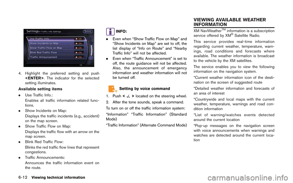
4. Highlight the preferred setting and push
setting illuminates.
Available setting items
. Use Traffic Info.:
Enables all traffic information related func-
tions.
. Show Incidents on Map:
Displays the traffic incidents (e.g., accident)
on the map screen.
. Show Traffic Flow on Map:
Displays the traffic flow with an arrow on the
map screen.
. Blink Red Traffic Flow:
Blinks the red traffic flow lines that represent
congestions.
. Traffic Announcements:
Announces the traffic information event on
the route.
INFO:
. Even when “Show Traffic Flow on Map” and
“Show Incidents on Map” are set to off, the
list display of “Info on Route” and “Nearby
Traffic Info” will not be affected.
. Even when “Traffic Announcement” is set to
off, the route guidance will not be affected.
Also, the announcement of emergency
information and weather information will not
be turned off.
Setting by voice command
1. Push <
>located on the steering wheel.
2. After the tone sounds, speak a command.
To turn on or off the traffic information system:
“Information” “Traffic Information” (Standard
Mode)
“Traffic Information” (Alternate Command Mode)
XM NavWeatherTMinformation is a subscription
service offered by XM®Satellite Radio.
This service provides real-time information
regarding current weather, temperature, warn-
ings, road conditions and forecasts where
available. The weather information is broadcast
to the vehicle by the XM satellites.
The service enables you to view the following
information on the navigation system.
*Current weather information icon of the desti-
nation on the screen of suggested route
*Detailed weather information and forecasts of
an area of interest
*Countrywide and local maps with the current
weather, temperature, warnings and road con-
dition information
*List of warning/watches events detected
around the current location
*Pop-up messages on the navigation screen
with voice announcements when warnings and
watches are detected around the current loca-
tion
VIEWING AVAILABLE WEATHER
INFORMATION