Page 67 of 315
Icons of various categories of locations can be
displayed on the map.
DISPLAYING MAP ICONS
Map icons can be displayed or hidden by type.1. Touch “Map Menu” while the current loca-tion map screen is displayed. 2. Select “Map Icons”.
NMA0053NMA0042
LOOKING AT INFORMATION ON THE
MAP
Map settings3-21
Page 68 of 315
3. Select the preferred icon. The icon displaysetting toggles between on and off each
time the key is touched. The indicator of the
selected icon illuminates. 4. Press MAP to return to the current location
map screen. The activated icons are dis-
played on the map.
INFO:
If registered in the map data, the brand icons will
be displayed on the map instead of the general
map icons listed below.
Map icons that can be displayed
●
Restaurant
●
Gas Station
●
Hotel
●
AT M
●
Rest Area Other settings
Landmark icons can also be set using the follow-
ing procedure.
NMA0043NMA0044
3-22Map settings
Page 69 of 315
1. Press SETTING.
2. Select “Navigation”.
3. Select “Map Icons”.
INFO:
The map icons are not displayed on the map
screen when the map scale is set to 1/4 mile
(500 m) or higher in the 2D map, or to 1 mile (2
km) or higher in Birdview™ map.
MAP SCROLLING INFORMATION
Information about the location on which the cen-
ter of the cross pointer is placed can be set to be
displayed. 1. Press SETTING. 2. Select “Navigation”.
3. Select “Others”.
NMA0045NMA0046NMA0047
Map settings3-23
Page 70 of 315
4. Select “Map Scrolling Information”.5. Select the preferred information item. The
indicator of the selected information item
illuminates.
Available information items:
● “Address Book Icons”
● “Destination/Waypoint Icons”
● “Latitude/Longitude Info.” 6. Press MAP to return to the current location
map screen. Move the cross pointer to the
set location to display the information.
MAP SYMBOLS
This navigation system uses symbols to display
facilities.
LNV0581NMA0049NMA0050
3-24Map settings
Page 73 of 315
ROAD COLOR
The road types are differentiated by colors.
Freeway: Red or Light Red (zoomed in)
Main road: Brown or Dark Yellow
Narrow street: Gray
Road with incomplete map data: Dark green
TRAFFIC INFORMATION ON MAP
With a subscription to XM NavTraffic�service,
traffic information is displayed.
“VIEWING AVAILABLE TRAFFIC IN-
FORMATION” (page 7-4)
Free Flow: Green arrow
Moderate traffic: Yellow arrow
Heavy traffic: Red arrow
Section affected by serious traffic event: Purple
dashed arrow Traffic information icons:
: Accident
: Closed Road
: Information
: Road Work
: Slippery Road
: Weather
: Incident
Map settings3-27
Page 78 of 315
INFO:
● It is also possible to select a region by touch-
ing the map on the right side of the screen.
● It is not possible to search for a route from the
continental United States to Hawaii.
SPECIFYING THE CITY
When searching for a destination with “Street
Address”, “Places”, “Freeway Entrance/Exit”,
“Intersection” or “City Center”, the search can
be narrowed down by specifying the city. 1. Select “Select a City” or “City”. 2. Enter the name of the city, select “List”. A
list screen is displayed.
INFO:
Select “Last 5 Cities” to display 5 cities recently
set as destinations.
NDE0004NDE0010
4-4Setting a destination
Page 79 of 315
3. Select the city of the destination from thelist.
INFO:
In some cases, when a city name has been
entered, the number of matching destinations in
the “Matches” column may be different from the
number displayed on the list screen. If this
occurs, enter more characters to further reduce
the number of matches.
FINDING AN ADDRESS
When the address of the destination is available,
use this method to enter the address and then
have the system calculate a route. A location
near the preferred destination can also be
searched for by entering the house number if the
map data contains the relevant data. 1. Press DEST and select “Street Address”. A
character input screen is displayed. 2. Enter the house number and select “OK”. If
the house number is not available, select
�No House #�. A street name input screen is
displayed.
NDE0005NDE0006NDE0007
Setting a destination4-5
Page 80 of 315
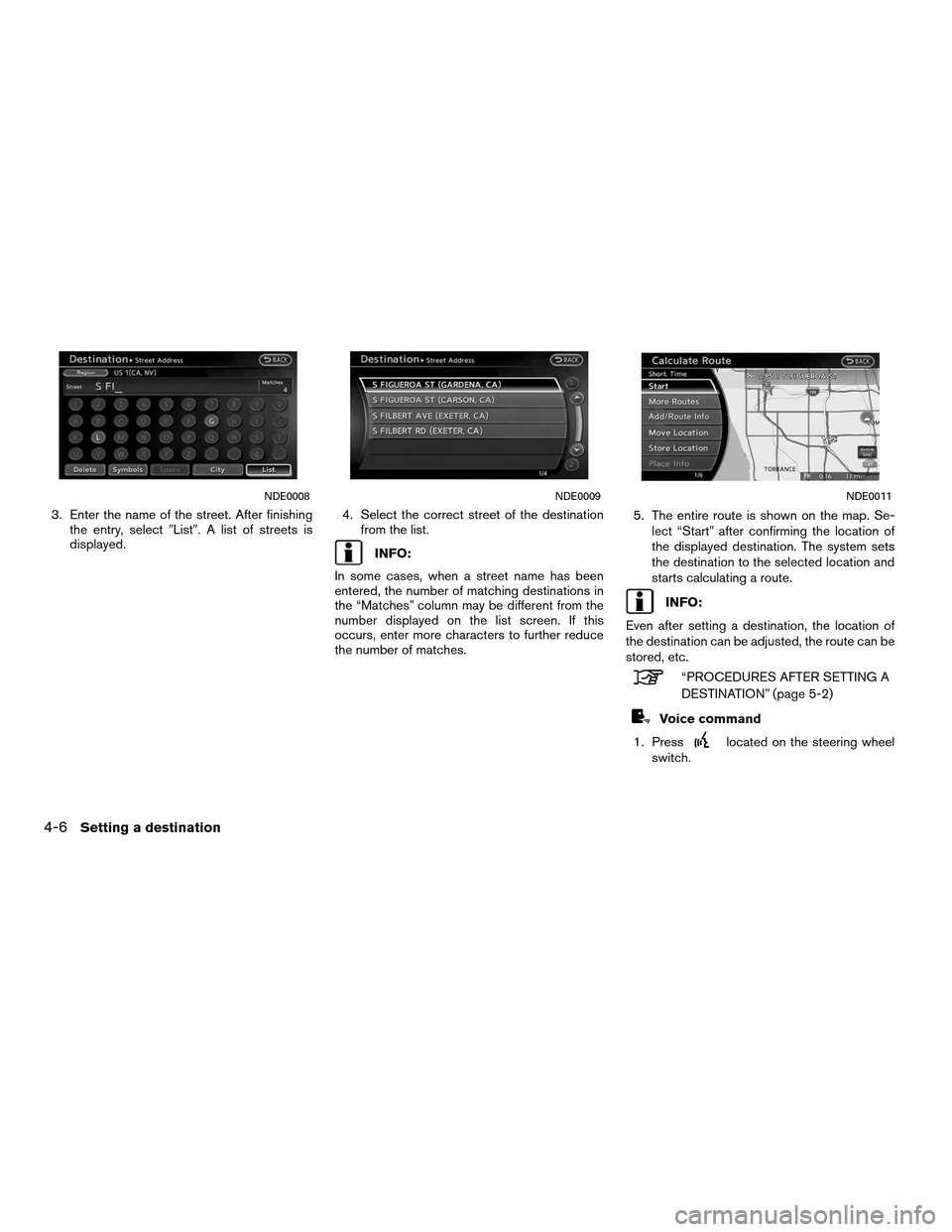
3. Enter the name of the street. After finishingthe entry, select �List�. A list of streets is
displayed. 4. Select the correct street of the destination
from the list.
INFO:
In some cases, when a street name has been
entered, the number of matching destinations in
the “Matches” column may be different from the
number displayed on the list screen. If this
occurs, enter more characters to further reduce
the number of matches. 5. The entire route is shown on the map. Se-
lect “Start” after confirming the location of
the displayed destination. The system sets
the destination to the selected location and
starts calculating a route.
INFO:
Even after setting a destination, the location of
the destination can be adjusted, the route can be
stored, etc.
“PROCEDURES AFTER SETTING A
DESTINATION” (page 5-2)
Voice command
1. Press
located on the steering wheel
switch.
NDE0008NDE0009NDE0011
4-6Setting a destination


 or higher in the 2D map,")


Main road: Brown or Dark Yellow
Narrow street: Gray
Road with incomplete map data: Dark green
TRAFFIC INFO")