2011 Acura CSX display
[x] Cancel search: displayPage 83 of 145

Navigation System83
System Setup
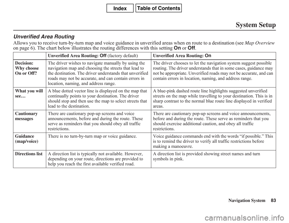
Unverified Area RoutingAllows you to receive turn-by-turn map and voice guidance in unverified areas when en route to a destination (see Map Overview
on page 6). The chart below illustrates the routing differences with this setting On or Off.
Unverified Area Routing: Off (factory default)Unverified Area Routing: On
Decision:
Why choose
On or Off?The driver wishes to navigate manually by using the
navigation map and choosing the streets that lead to
the destination. The driver understands that unverified
roads may not be accurate, and can contain errors in
location, naming, and address range.The driver chooses to let the navigation system suggest possible
routing. The driver understands that in some cases, guidance may
not be appropriate. Unverified roads may not be accurate, and can
contain errors in location, naming, and address range.
What you will
see…A blue dotted vector line is displayed on the map that
continually points to your destination. The driver
should stop and then use the map to select streets that
lead to the destination.A blue-pink dashed route line highlights suggested unverified
streets on the map while travelling to your destination. This is in
sharp contrast to the normal blue route line displayed in verified
areas.
Cautionary
messagesThere are cautionary pop-up screens and voice
announcements, before and during the route. These
serve as reminders that you should obey all traffic
restrictions.There are cautionary pop-up screens and voice announcements,
before and during the route. These serve as reminders that you
should exercise additional caution, and obey all traffic
restrictions.
Guidance
(map/voice)There is no turn-by-turn map or voice guidance. Voice guidance commands end with the words “if possible.” This
is to remind the driver to verify all traffic restrictions before
making a manoeuvre.
Directions listA direction list is typically not available. However,
depending on your route, directions are provided to
help you reach the first available verified road.A direction list is provided showing street names and turn
symbols in pink.
Page 84 of 145

84
Navigation System
System SetupUnverified Area RoutingWhen driving to your destination, you
have the choice of using or not using
“unverified” roads. You make this
choice in the Setup screen (second).
The next few pages contain an example
of a route to a destination in an
unverified area explaining the routing
differences found in unverified areas.
Note that the “Unverified” roads are
displayed only on the U.S. areas.
With Unverified Area Routing Off,
the system tries to use verified roads
whenever possible. In this example,
since only verified streets are used, it
created a longer route than necessary.
With Unverified Area Routing On,
the route is shorter, but consists of
unverified (light coloured) streets that
may not be accurate. Because the streets
are unverified, there may be errors in
street location, name, or address range.
Additional caution is recommended in
these areas. Always obey posted traffic
restrictions.Because both routes bypass or use
unverified streets, an initial Disclaimer
screen is provided. It is recommended
that you stop and review the map.
Unverified Area Routing “Off”Unverified Area Routing “On”
NOTE:
Unverified roads are shown only when
viewing the map in the 80, 200, and 400
metre map scales, or the 1/20, 1/8, and
1/4 mile map scales.
Page 87 of 145

Navigation System87
System Setup
Edit Avoid AreaThis function allows you to select areas
you wish to avoid when calculating a
route to your destination. You can select
up to five areas to avoid. You may wish
to set up an “avoid area” to route around
long-term road construction, closures,
or any area you wish to avoid. If you
enter a route that takes you through or
into an “avoid area,” a pop-up box will
warn you that your route takes you into
one of these areas. However, you can
still choose destinations in an avoided
area.When you select Edit for the setup item
“Edit Avoid Area,” the following list
screen is displayed:
You can select New Area or select (by
touch) one of your existing areas to
modify. If you choose New Area, the
following screen is displayed:Say or select Edit Name, and use the
keyboard to enter the name on the Enter
avoid area name screen (19 characters
max). Say or select Done to return to
the previous screen. Say or select Edit
Area to create the area to be avoided.
The following screen appears:
Page 88 of 145

88
Navigation System
System SetupEither select Address or Map Input
on the Enter avoid area by screen.
Each choice provides a slightly different
way to locate the approximate map
display for drawing the area you wish to
avoid. After selecting the choice, a map
screen will be displayed.
Use the ZOOM buttons to select the
map scale (available scales are 80, 200,
and 400 metre scales). Use the joystick
to move the crosshairs (red circle) to the
desired start point and push in the
joystick to “set” the start point. Then
move the joystick in a straight or
diagonal direction to encompass the
area to be avoided.NOTE:
The maximum size of the “Avoid area”
is 1/4 of the navigation display screen
regardless of the map scale setting.
The selected area will be displayed as a
shaded box with a yellow border. Push
in on the joystick to set the end point of
the avoided area. To “redraw” the area,
touch Cancel and repeat the area
selection process. If your selected area
contains a highway, the system will
prompt you with a pop-up box saying
“Do you want to avoid highways?”Answering “No” allows you to enter a
route through an avoided area on a
highway and skip the “Avoid area
caution box” (see Pop-Ups and
Disclaimers on page 62).
Say or select Done to return to the Edit
area screen. When you return, the
“Vicinity” field is automatically filled in
by the system. Re-edit the area “Name”
if desired. Select Done on the Edit
avoid area screen to finish editing.
Your new avoided area will now appear
on the “Avoid area” list and be viewable
on the map screen.
Page 90 of 145

90
Navigation System
System SetupFor “Places Along the Route,” the
system looks in front of you within a
corridor width specified by your values
for “On Highways” or “On Surface
Street.” The system checks the
upcoming area, based on your input.
For “Places Around the Destination,”
the system searches outwards in a spiral
from the destination. In this case,
specific search values are not needed;
the matches are displayed in order of
distance from destination.
NOTE:
These settings do not affect the search
range used for the voice commands like
“Find nearest gas station” that are also
available when viewing the map screen.
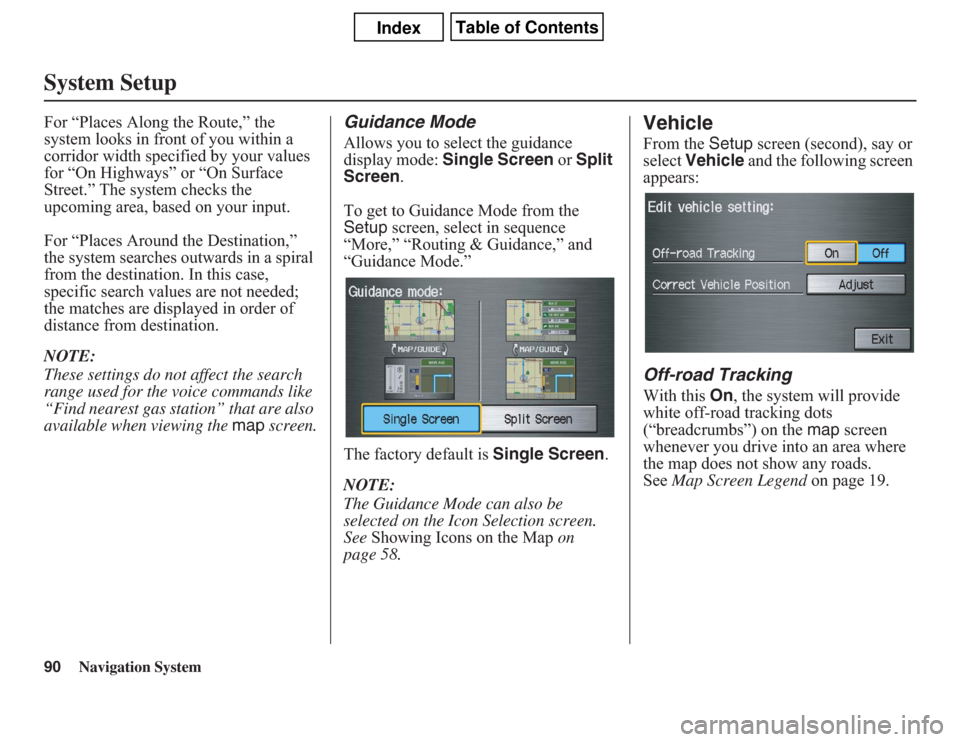
Guidance ModeAllows you to select the guidance
display mode: Single Screen or Split
Screen.
To get to Guidance Mode from the
Setup screen, select in sequence
“More,” “Routing & Guidance,” and
“Guidance Mode.”
The factory default is Single Screen.
NOTE:
The Guidance Mode can also be
selected on the Icon Selection screen.
See Showing Icons on the Map on
page 58.
VehicleFrom the Setup screen (second), say or
select Vehicle and the following screen
appears:Off-road TrackingWith this On, the system will provide
white off-road tracking dots
(“breadcrumbs”) on the map screen
whenever you drive into an area where
the map does not show any roads.
See Map Screen Legend on page 19.
Page 91 of 145

Navigation System91
System Setup
After you have travelled approximately
800 metres away from a mapped road,
the system will display a series of white
dots on the map screen to show the path
you have travelled. This is provided so
you can follow the dots to backtrack to
the mapped road you originally left.
Tracking continues until you reach a
mapped road. See Off-road Tracking on
page 60.
Tracking is shown only in the 80, 200,
400, and 800 metre scales, or the 1/20,
1/8, 1/4, and 1/2 mile scales. Use the
ZOOM buttons to change the scales if
necessary.
NOTE:
To clear existing dots, turn this feature
off and exit Setup. To re-enable this
feature, return to Setup and turn it on
again.
Correct Vehicle PositionThe system relies on satellites for
positioning information. Buildings,
tunnels, and other objects can block or
reflect these signals, requiring the
system to use “dead reckoning” to
determine your location and direction.
This can sometimes lead to small errors
in positioning, such as showing you on
an adjacent street.
NOTE:
Using this function to adjust vehicle
position is not recommended. When the
system acquires a GPS signal, it will
automatically place the vehicle in the
correct location.
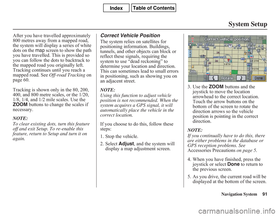
If you choose to do this, follow these
steps:
1. Stop the vehicle.
2. Select Adjust, and the system will
display a map adjustment screen.3. Use the ZOOM buttons and the
joystick to move the location
arrowhead to the correct location.
Touch the arrow buttons on the
bottom of the screen to rotate the
direction arrows so the vehicle
position is pointing in the correct
direction.
NOTE:
If you continually have to do this, there
are either problems in the database or
GPS reception problems. See
Accessories Precautions on page 5.
4. When you have finished, press the
joystick or select Done to return to
the previous screen.
5. As you drive, the current road will be
displayed at the bottom of the screen.
Page 92 of 145

92
Navigation System
System SetupSystem InformationFrom the Setup screen (second), say or
select System Information and the
following screen appears:
This information is for dealer use only.
For ordering updates, use the version
number stamped on the label (as Ver. X.
XX) of the navigation DVD. See
Obtaining a Navigation Update DVD on
page 103.
When finished, say or select Return to
return to the previous screen.
Basic SettingsFrom the Setup screen (second), say or
select Basic Settings and the
following screen appears:Keyboard LayoutAllows you to select the displayed
keypad screen: Alphabet or
QWERTY.Units (km or mile)Allows you to select the units for the
entire system (km or mile).
Voice Recognition FeedbackAllows you to turn voice control system
prompts On or Off. When Off, you will
not hear the voice control system
confirmations or prompts.
Page 93 of 145

Navigation System93
System Setup
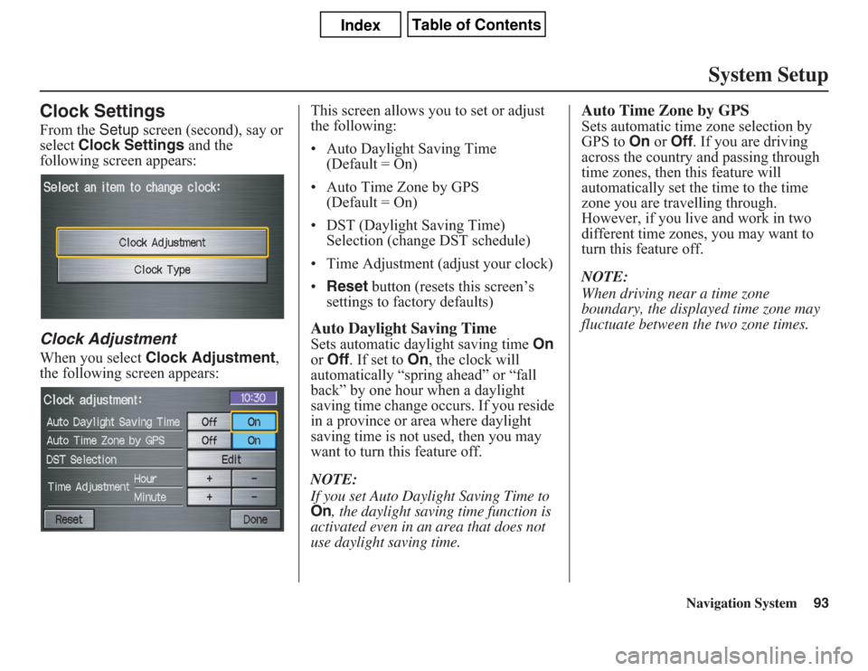
Clock SettingsFrom the Setup screen (second), say or
select Clock Settings and the
following screen appears:Clock AdjustmentWhen you select Clock Adjustment,
the following screen appears:This screen allows you to set or adjust
the following:
• Auto Daylight Saving Time
(Default = On)
• Auto Time Zone by GPS
(Default = On)
• DST (Daylight Saving Time)
Selection (change DST schedule)
• Time Adjustment (adjust your clock)
•Reset button (resets this screen’s
settings to factory defaults)
Auto Daylight Saving TimeSets automatic daylight saving time On
or Off. If set to On, the clock will
automatically “spring ahead” or “fall
back” by one hour when a daylight
saving time change occurs. If you reside
in a province or area where daylight
saving time is not used, then you may
want to turn this feature off.
NOTE:If you set Auto Daylight Saving Time to On
, the daylight saving time function is
activated even in an area that does not
use daylight saving time.
Auto Time Zone by GPSSets automatic time zone selection by
GPS to On or Off. If you are driving
across the country and passing through
time zones, then this feature will
automatically set the time to the time
zone you are travelling through.
However, if you live and work in two
different time zones, you may want to
turn this feature off.
NOTE:
When driving near a time zone
boundary, the displayed time zone may
fluctuate between the two zone times.