Page 229 of 332

227
03NAVIGATION - GUIDANCE
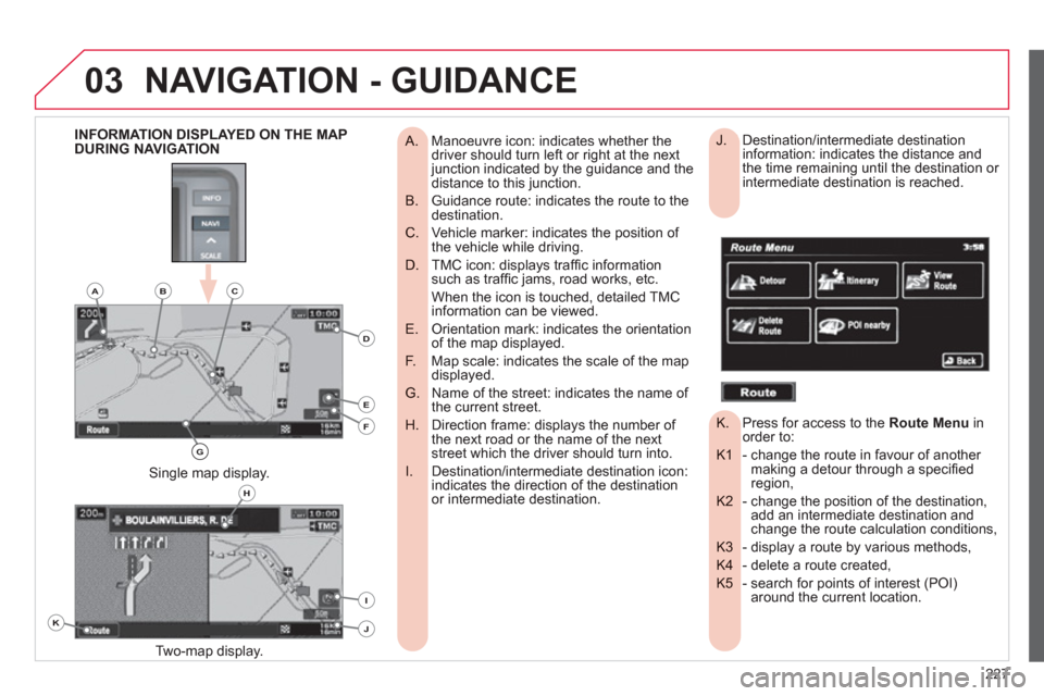
Manoeuvre icon: indicates whether the
A. driver should turn left or right at the next junction indicated by the guidance and thedistance to this junction.
Guidance route: indicates the route to the
B. destination.
Vehicle marker: indicates the position of
C. the vehicle while driving.
TMC icon: displays traffi c information
D. such as traffi c jams, road works, etc.
When the icon is touched, detailed TMC information can be viewed.
Orientation mark: indicates the orientation
E. of the map displayed.
Map scale: indicates the scale of the map
F. displayed.
Name of the street: indicates the name of
G. the current street.
Direction frame: displays the number of
H. the next road or the name of the nextstreet which the driver should turn into.
Destination/intermediate destination icon:
I. indicates the direction of the destinationor intermediate destination.
Two-map displa
y.
Single map display.
INFORMATION DISPLAYED ON THE MAP
DURING NAVIGATION Destination/intermediate destination
J. information: indicates the distance and
the time remaining until the destination or
intermediate destination is reached.
Press for access to the
K. Route Menuinorder to:
- change the route in favour of another K1 making a detour through a specifi edregion,
- change the position of the destination, K2 add an intermediate destination and change the route calculation conditions,
- display a route by various methods, K3
- delete a route created, K4
- search for points of interest (POI) K5 around the current location.
K
H
E
F
BCA
D
G
I
J
Page 232 of 332
230
03
NAVIGATION SETTINGS AND
INFORMATION (1/2) - Select the settings of functions linked with the G navigation to:
- set the screen display parameters such as: G1
- display 1 or 2 maps,
- display or do not display the POIs on the map, display selected icons,
- change the colours of the map,
- display or do not display the name of the currentstreet.
- display or do not display the address of the current street.
- set route conditions, such as:G2
- avoiding traffi c problems,
- avoiding selected areas,
- avoiding roads at a certain time.
- set the route guidance mode and the displayingG3 of the results of the route search.
- save, change or delete a location in the addressG4 book,
- display and select the traffi c information such as G5 traffi c jams or road works by selecting dynamic guidance.
NAVIGATION - GUIDANCE
G1G2G3
G4G5
G
Page 234 of 332

232
03
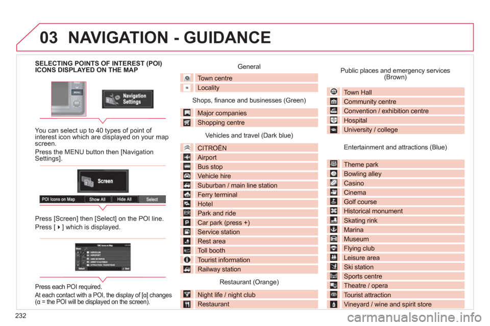
SELECTING POINTS OF INTEREST (POI) ICONS DISPLAYED ON THE MAP
You can select up to 40 t
ypes of point of interest icon which are displayed on your map screen.
Press the MENU button then [Navi
gation Settings].
Press [
Screen] then [Select] on the POI line.
Press [��] which is displayed.
Press each POI required.
At each contact with a POI, the display of [α] changes(α = the POI will be displayed on the screen).
General
Town centre
Locality
Shops, fi nance and businesses (Green)
Major companies
Shopping centre
Vehicles and travel (Dark blue)
CITROÀN
Airport
Bus stop
Vehicle hire
Suburban / main line station
Ferry terminal
Hotel
Park and ride
Car park (press +)
Service station
Rest area
Toll booth
Tourist information
Railway station
Restaurant (Orange)
Night life / night club
Restaurant
Public places and emergency services(Brown)
Town Hall
Community centrey
Convention / exhibition centre
Hospitalp
University / college
Entertainment and attractions (Blue)
Theme park p
Bowling alley gy
Casino
Cinema
Golf course
Historical monument
Skating rink g
Marina
Museum
Flying clubyg
Leisure area
Ski station
Sports centrep
Theatre / opera p
Tourist attraction
Vineyard / wine and spirit store
NAVIGATION - GUIDANCE
Page 235 of 332
233
03
Entering an address and starting guidance (1/2)
Press
ExplanationResult
Pr
ess the MENU button.
Press [Address
/Junction].
Press [Countr
y] and enter the name of the country using the touch keypad.
When a character of the name of the countr
y is entered, if 5 countries or fewer are
recognised, you can select a country from a list which is displayed or press [List].
You can select one of the 5 most recently selected countries by pressing [Last 5]on the "Country" line.
Press [
City] then [Keyword] and enter the name of the city using the touch keypad.
When a character o
f the name of the city is entered, if 5 cities or fewer are recognised,you can select a city from a list which is displayed or press [List].
You can select a city using the post code.
Press [Post Code] and enter the number.
NAVIGATION - GUIDANCE
You can select one of the 5 most recently selected cities by pressing [Last 5] on the "City" line.
Page 236 of 332
234
03
Entering an address and starting guidance (2/2)
Press
Explanation Result
Press [Street] and enter the name of a street usin
g the touch keypad.
When a character of the name of the street is entered, if 5 streets or fewer are
reco
gnised, you can select a street from a list which is displayed or press [List].
Press [House
#] and enter the number of the house using the touch keypad.
You can enter the name of a junction instead of the number of thestreet. Press [Junction] and select the name from a list which isdisplayed.
Thi
s is the result once all of the information has been entered:
If
you agree with the information press [Set], otherwise press one of the buttons to correct.
Press [Start] to start the navi
gation.
/
NAVIGATION - GUIDANCE
Page 237 of 332
235
03
TRAFFIC INFORMATION
Press
Explanation
Result
Press [Route].
Press [Displa
y new route].
The s
ystem offers a detour route (dynamic guidance).
Press [Back] and enter to return to the previous screen.
The s
ystem asks you to confi rm or not the new route.
Press [Yes] to confi rm your choice. The system displays the name of the new route.
Press [No] to not register the route.
During navigation, the system gives you traffi c
information received in real time.
The s
ystem can then suggest a detour route, if dynamic guidance has been activated by pressingMENU, [Navigation settings] then [TMC].
NAVIGATION - GUIDANCE
Page 238 of 332

236
04
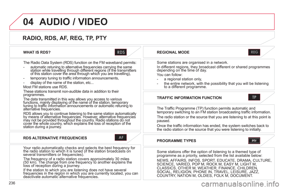
WHAT IS RDS?
The Radio Data
System (RDS) function on the FM waveband permits: - automatic retuning to alternative frequencies carrying the samestation while travelling through different regions (if the transmittersgqyggqyg
of this station cover the area through which you are travelling),gg g(gg g(
- temporary tuning to traffi c information announcements,
- display of the name of the station, etc...
Most FM stations use RDS.
These stations transmit non-audible data in addition to their programmes. The data transmitted in this way allows you access to variousfunctions, mainly displaying of the name of the station, temporary yyyy
tuning to traffi c information announcements or automatic retuning to y pyg p yy pyg p
alternative frequencies.gg
RDS allows you to continue listening to the same station automatically by means of alternative frequencies. However, alternative frequencies yg yyg
may not be provided throughout the country. Radio stations do not yq qqq
cover the whole country, which explains the loss of reception of the yp g ypg y
station during a journey. y
REGIONAL MODE
Some stations are organised in a network.
In different regions, they broadcast different or shared programmesdepending on the time of day. gyg,y
You can follow:
- a regional station only,
- the entire network, with the possibility that you will be listeningto a different programme.
RADIO, RDS, AF, REG, TP, PTY
AUDIO / VIDEO
RDS ALTERNATIVE FREQUENCIES
Your radio automatically checks and selects the best frequency for the radio station to which it is tuned (if the station broadcasts on yqyyq
several transmitters or frequencies). The frequency of a radio station covers approximately 30 miles(50 km). The change from one frequency to another explains theq y pp yq y pp y
loss of reception during a journey. () g q() g
If the station to which you are listening does not have several frequencies in the region in which you are currently located, you canygyg
deactivate automatic alternative frequencies. qgyqgy
TRAFFIC INFORMATION FUNCTION
The Tra
ffic Programme (TP) function permits automatic and
temporary switching to an FM station broadcasting traffi c information.
The radio station or the source that
you are listening to at this point ispaused.
Once the traffi c information has ended, the system switches back to
the radio station or the source that you were listening to initially.
PROGRAMME TYPES
Some stations offer the option of listening to a themed type of
programme as a priority, selected from the list available below:
NEWS, AFFAIRS, INF
OS, SPORT, EDUCATE, DRAMA, CULTURE,SCIENCE, VARIED, POP M, ROCK M, EASY M, LIGHT M, CLASSICS, OTHER M, WEATHER, FINANCE, CHILDREN,SOCIAL, RELIGION, PHONE IN, TRAVEL, LEISURE, JAZZ,COUNTRY, NATION M, OLDIES, FOLK M, DOCUMENT.
Page 239 of 332

237
04AUDIO / VIDEO
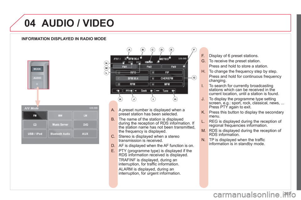
INFORMATION DISPLAYED IN RADIO MODE
A preset number is displayed when a
A. preset station has been selected.
The name of the station is displayed
B. during the reception of RDS information. If
the station name has not been transmitted,
the frequency is displayed.
Stereo is displayed when a stereo
C. transmission is received.
AF is displayed when the AF function is on.
D.
PTY (programme type) is displayed if the
E. RDS information received is displayed.
TRAFINF is displayed, during an interruption, for traffi c information.
ALARM is displayed, during an interruption, for urgent information.
Display of 6 preset stations.
F.
To receive the preset station.
G.
Press and hold to store a station.
To change the frequency step by step.
H.
Press and hold for continuous frequency changing.
To search for currently broadcasting
I. stations which can be received in the current location, until a station is found.
To display the programme type setting
J. screen, e.g.: sport, rock, classical, news, ...
Press PTY again to exit.
Press this button to display the secondary
K. menu.
REG is displayed during the reception of
L. regional frequencies information.
RDS is displayed during the reception of
M. RDS information.
TP is displayed when the traffi c
N. information is in standby mode.
ABCDE
G
HIJK
LMN
F