Page 117 of 206
117 Navigation*
Navigation main menu
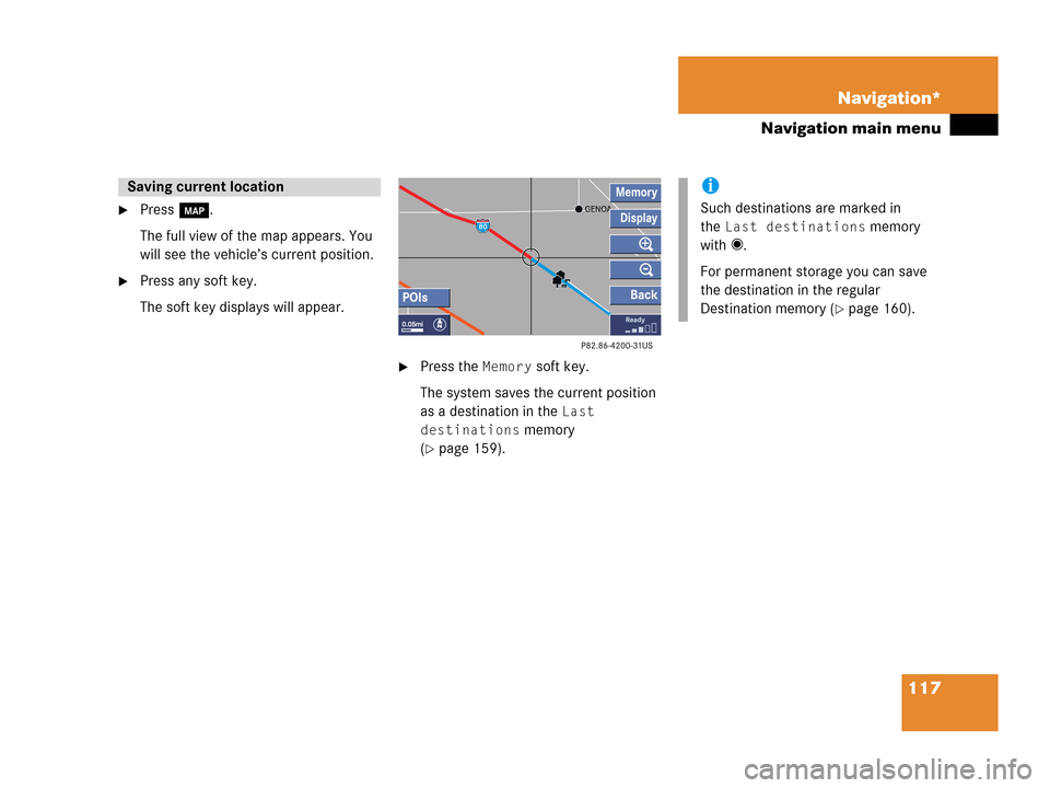
�Press c.
The full view of the map appears. You
will see the vehicle’s current position.
�Press any soft key.
The soft key displays will appear.
�Press the Memory soft key.
The system saves the current position
as a destination in the
Last
destinations
memory
(
�page 159).
Saving current locationi
Such destinations are marked in
the
Last destinations memory
with _.
For permanent storage you can save
the destination in the regular
Destination memory (
�page 160).
Page 119 of 206

�in the Enter city menu (�page 125).
The Select state/province menu will
appear.
Select state/provi")
119 Navigation*
Destination input
�Press the State soft key
�in the Enter street menu
(
�page 118)
�in the Enter city menu (�page 125).
The Select state/province menu will
appear.
Select state/province menu
�Push the joystick to g or G to
select a state.
�Press E.
The Enter street menu will reappear
and shows the new state code in the
middle of the screen.
Toggling between State and Province
list
You can toggle between states in the USA
and provinces in Canada.
�Push the joystick to H or h.
State of Hawaii
When on the mainland, you cannot choose
destinations in Hawaii, because these are
in a database separate from the USA/
Canada. Similarly, when in Hawaii, you cannot choose mainland destinations. The
message
You must change the state
or province in order to use that
destination
will appear in this case, if
such a destination is selected from the last
destinations memory (
�page 159), the
destination memory (
�page 161) or as
home address (
�page 131).
�Choose another state or province.
The warning message
This selec-
tion will restart the system.
Last destinations may not be
available, and today’s plan
will be erased. Do you wish to
continue?
will appear.
�Push the joystick to H to select Yes.
�Press E to restart.
Selecting the state/province
i
Use the State list for selecting states in
the USA and the Province list for
selecting provinces in Canada.
i
If you have already calculated a route,
you can toggle to the Last list, which
contains up to 5 last selected states or
provinces.
i
After such a restart, Today’s Plan
entries are all deleted. Destinations in
the previous area (for example in Last
Destinations) are kept so that you can
access and delete them.
Page 120 of 206

push the joystick to h, H, g or
G to select the characters. After each
selection, press E.
�Push the joyst")
120 Navigation*
Destination input
Entering a street
�In the Enter street menu (�page 118)
push the joystick to h, H, g or
G to select the characters. After each
selection, press E.
�Push the joystick to F or f to
select characters diagonally.
or
�Press one of the number keys 1 to
9 and 0 to enter digits.
�Press the Delete soft key if
necessary.
The character last entered by the
system is deleted.
Back to the previous menu
�Press the Back soft key.
Confirming a street (menu)
�Press E longer than 2 seconds.
or
�Select the ( symbol. Push the
joystick to h, H, g or G to do
so.
�Press E.
Entering destination address
i
If you enter the first character, the
State and City soft keys disappear.
The status bar shows the number of
current matches.
i
For quicker input, COMAND offers
available characters from the character
set based on your selections and the
names of the streets stored on the
navigation DVD. The character
selected appears magnified.
Greyed out characters are not available
and cannot be selected.
i
If there is only one match for the
entered street name, the ( symbol is
highlighted automatically.
Page 125 of 206
125 Navigation*
Destination input
Confirming a cross street (list)
�Press E to confirm.
The Start route guidance menu
(
�page 135) will appear.
Entering a city
�Press the City soft key in the Enter
street menu (
�page 118).
Enter city menu
The most recently entered destination is
shown in the upper area.You can now
�enter a city name or
�accept the city name shown
Available soft keys:
�Map soft key:
Brings you to the destination input
directly above the map (
�page 129).
�State soft key:
Brings you to the state/province
selection (
�page 119).
�List soft key:
Brings you to a list of cities with the
previously input street.
�Delete soft key:
The character last entered or the
character last accepted by the system
is deleted.
�Back soft key:
Returns you to the previous menu.
i
The currently set state is identifed by
the state code in the middle of the
screen.
If the vehicle location is in Canada, this
soft key appears as
Province.
Page 129 of 206

129 Navigation*
Destination input
Selecting a destination using the map
�Press c.
�Push the joystick to H, h, g, G,
F, f.
or
�Press the Map soft key, e.g. in the Start
route guidance menu (
�page 135).
The map is shown in full view and
cross-hairs appear.If soft key displays are hidden:
�Press any soft key.
The soft key displays will appear.Available soft keys
�POIs soft key:
Spotlight a POI if POIs are on the map
(
�page 166).
�Memory soft key:
Set a memory point and saved it in the
Last destinations memory
(
�page 117).
i
Select a destination using the map
when vehicle is stationary. If you
choose to confirm a selected
destination by pressing E while the
vehicle is in motion, the message
It
is not possible to set a
destination via map during
driving
will appear in the display.
i
The system automatically places the
cross-hairs on the current destination
address.
i
c was pressed:
If no soft key is selected within approx.
8 seconds, the soft key display will
disappear again.
i
The POIs, Memory and Display soft
keys are available if the
Map soft key
was pressed.
Page 130 of 206
.
�Soft key +:
Enlarge visible map section.
�Soft key ):
Reduce visible map section.
�Back soft key:")
130 Navigation*
Destination input
�Display soft key:
The Map view display will appear.
(
�page 153).
�Soft key +:
Enlarge visible map section.
�Soft key ):
Reduce visible map section.
�Back soft key:
Returns you to the previous menu.
�Push the joystick to H, h, g, G
to move the cross-hairs.
�Push the joystick to F or f to move
the cross-hairs diagonally.This allows you to select your destination.
�Release the button.
If the system is able to assign a street
name to the selected location, it is
displayed on the status bar.
If a street name can not be assigned,
COMAND increases the zoom by one
increment each time E is pressed
until a street name can be selected.
�Press E.
The system uses the point at the center
of the cross-hairs as destination.
The Start route guidance menu will
appear (
�page 135).
i
If you press the Back soft key, your
selection will be discarded. The system
then uses the data of the previous
destination.
i
If a POI is close to the center of the
cross-hairs, a selection list will appear.
You can now select between a POI and
the address destination.
Page 134 of 206
134 Navigation*
Destination input
Additional information for 1, 3 and 4
IndicationRemarks and
value range
1 Steering angle Pointer shows to the
left
-35° to 0°
Pointer shows to the
right
0° to +35°
3 Dynamic
compass card 0° to 360°
4 Height above
the sea level i
The white indicator
is fixed, the scale
scrolls as vehicle
altitude changes
Scale range:
The display unit is
set to miles
-328 ft to 19680 ft
The display unit is
set to km
-100 m to 6000 m
IndicationRemarks and
value rangei
Using the control system, the display
unit can be changed between km or
miles (see your vehicle’s Operator’s
Manual).
�When the instrument cluster
multifunction display is set to miles,
the COMAND will indicate
distances in miles (mi) or feet (ft)
�When the instrument cluster
multifunction display is set to
kilometers, the COMAND will
indicate distances in kilometers
(km) or meters (m)
Page 135 of 206

135 Navigation*
Route guidance
� Route guidance
Route guidance can be started if the
destination input is complete and
Start
route guidance
is displayed at the
bottom of the main area.
Start route guidance menu
1Destination address
2Arrow indicates the direction to the
destination and the distance to the
destination (as the crow flies)
�Press E.
Route calculation and route guidance
begins.
1Routing mode
Setting the routing mode (
�page 116)
2Arrow indicate the direction of the
destination, the distance to destination
and
CALC RTE indication
3The road you are currently driving onRoute calculation can take some time,
depending on the distance to the
destination and the routing mode.
During route calculation, an arrow pointing
towards the destination, the distance to
the destination (as the crow flies) and
CALC RTE are displayed.
Route guidance begins when route
calculation is complete.
The system will calculate a new route
during active route guidance if the driver
does not follow the route guidance.
Starting route guidance
Route calculation
Recalculating an existing route