Page 25 of 50
Navigation
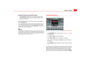
24Destination memoryStoring destination, stopover destination, flagged destination or location
Storing the different destinations means giving them a name
and storing them in the MFD2 radio navigation system.
– After entering a new address, press (starting from the Nav igation
main menu) ⇒ page 17, fig. 13: , .
– Press to open the letter input menu.
– Enter a name for the destination, like for example “Mr. Sm ith” or
“Vacations-accomodations”.
– Press to save the destination with the name.The destination can now be called up from the memor y as you need it. The
name should be short and clear. You can also use th e names that are
suggested.
You enter the destination name in the same way u sed for entering a street
name ⇒
page 19.
Fig. 24 Editing the
memory
Fig. 25 Storing the desti-
nation
Destination
Edit memory
Store dest.OK
radionaving Seite 24 Mittwoch, 30. März 2005 12 :26 12
Page 26 of 50
Navigation25
Renaming destination– Starting in the Navigation main menu ⇒
page 17, fig. 13 , press
followed by then .
– Turn the menu knob to move the red bar to the name that you
wish to change.
– Press the menu button to call up the entry function for the lett ers.
– Edit the name ⇒
page 19.
– If, however, you wish to keep the original name and n ot the new
one, press the button ⇒
page 4, fig. 1 . Your alterations
will not be stored.
Sorting destinations
The various different addresses in the destination memory
are stored chronologically according to their entry date and
can be sorted at a later date according to your requirements.
Fig. 26 Renaming a desti-
nation
Destination
Edit memory
Rename destination
ESC
A11
Fig. 27 Sort: SelectFig. 28 Sort: Store
radionaving Seite 25 Mittwoch, 30. März 2005 12 :26 12
Page 27 of 50

Navigation
26
– Starting in the Navigation main menu ⇒
page 17, fig. 13 press
followed by then .
– Turn the menu knob to move the red bar to the destination t hat
you would like to save in another position.
– Press the menu knob. Sort: Store. now appears at the top of the
screen. You can now move the address up or down by tu rning the
menu knob.
– Press to store the address in the new position. Sort: select
now appears again at the top of the screen.
– Press the button ⇒
page 4, fig. 1 to close the sort func-
tion.The other destinations will be moved down if you mo ve a destination to a
position that is already occupied.
Deleting individual destinations or the entire destination memory
You can, in contrast to the "last destination" memory, delete
individual destinations fr om the destination memory.
Destination
Edit memory
Sort destinations
OK
ESC
A11
Fig. 29 Deleting destina-
tion memoryFig. 30 Selecting entry to
delete
radionaving Seite 26 Mittwoch, 30. März 2005 12 :26 12
Page 28 of 50
Navigation27
Deleting an individual entry
– Starting in the Navigation main menu ⇒
page 17, fig. 13 press
followed by then .
– Turn the menu knob to move the red bar to the destination that you would like to delete and then press the menu knob.
– When asked for confirmation, press . If you d o not wish to
delete the destination, press .
Deleting the entire destination memory
– Starting in the Navigation main menu press followed
by then .
– When asked for confirmation, press . If you do no t wish to
clear the destination memory, press .
Parameters for route calculationRoute options
Destination
Edit memory
Delete destination
Delete
Cancel
Destination
Edit memory
Clear dest. memory
DeleteCancel
Fig. 31 Route optionsFig. 32 Symbols for
traffic problems
radionaving Seite 27 Mittwoch, 30. März 2005 12 :26 12
Page 29 of 50

Navigation
28
– Press in the navigation main menu ⇒
page 17,
fig. 13.A short route might be quicker for your purpose in larg er towns or cities where
there are a lot of traffic jams. Route options can be altered w hilst the route
guidance function is active. The changed parameters w ill be used as a basis
for the calculation of the remaining journey.
Function keys in the route option menu•
Fast or Short: Determines whether a fast or short route should be c alcu-
lated.
•
Dynam. : Dynamic route guidance responds to traffic reports broadc ast by
TMC stations. This function will automatically guide yo u round traffic jams or
blocked roads.
, or – Determines whether motorways, ferri es or toll
roads should be used. These options will, however, be used for calculation if
there is no other logical route to the d estination (e.g. an island is to be used
without using a ferry).
– Stores the selected settings for future route guidance usage.
Dynamic route guidance
An announcement that there are traffic jams on your route w ill be made if a
traffic jam is registered. “You will also be warned directly be fore the”“traffic
jam itself”.
Once the dynamic route guidance function has been activ ated you will be
informed that the “route is being recalculated due to tr affic problems” if any
have been registered.
Traffic problems are indicated by a symbol on the map:
Traffic jam
⇒
page 27, fig. 32
Slow-moving traffic
Road closed
The navigation system will calculate the quickest poss ible route when the
dynamic route guidance option is active. The sys tem might well guide you
through a traffic jam if the diversion would be longer.Note
•
The dynamic route guidance option will only function if you are receiving
at least one TMC radio station.
•
The MFD2 radio navigation system will automatically loo k for a new TMC
station if you leave the re ception area of the one you are using. The station
you are listening to, however, does not have to be a TMC s tation.
•
The dynamic route guidance option wi
ll always use motorways, ferries
and toll roads.
•
The navigation CD-ROM should be compatible with th e TMC data.
•
The quality of the dynamic route gu
idance depends on the information
contained in the traffic announcements. The radio stations broadcasting this
information are responsible for the content.
Route opt.
RutaMotorway
Ferry
Toll
By default
AA
AB
AC
radionaving Seite 28 Mittwoch, 30. März 2005 12 :26 12
Page 30 of 50

Navigation29
Settings
The vehicle position can be entered manually and you can
then start a demonstration journey.
Entering your position
– Press in the Navigation main menu ⇒
page 17, fig. 13
to enter the vehicle position.
– Press . The entry window for the town appears.
The entry for the street is made after you make your en try and
confirm it with . After confirming the name of the street y ou
will see a list of the streets which have an intersection w ith the
named street.
– Select the intersection and confirm your choice by press ing the
menu knob.
– Now enter your position either before or after this intersec tion in
metres and also enter the directio n of travel using the points of
the compass.
– Confirm your entry by pressing . The screen disp lay will return
to the Navigation main menu.
Entering your position on the map
– Press successively and to see your set
position on the map. The scale of the map can be altered us ing
the two top left-hand function keys.
– Press the button ⇒
page 4, fig. 1 twice to return to the
Navigation main menu.
Starting the demonstration
– Press and then select active. The navigation system is
activated.
Fig. 33 Settings in the
Navigation main menuFig. 34 Position settings
SettingsPosition location
OK
OK
Settings
Position map
ESC
A11
Demo
radionaving Seite 29 Mittwoch, 30. März 2005 12 :26 12
Page 31 of 50

Navigation
30
– The MFD2 radio navigation system will now travel along the rout e
virtually from start to finish if the route guidance function is
started. You can listen to announcements and look at di splays.The navigation system will need some time for an exact definition of your
position if you have transported your vehicle using the tr ain or a ferry. Your
position can be entered manually if the automatic defi nition is not
successful.
The manual position input can be used to calculate a route between any two
points regardless of where the vehicle is actually loca ted.Manually excluding stretches of the journey
Stretches of the journey ahead and/or parts of the route list
can be blocked manually.
Menu for blocking and traffic jams
– Press the traffic jam button
⇒
page 4, fig. 1 if you want to
block a stretch of the route ahead.
Entering traffic jam information
–Press ⇒fig. 35 .
– Turn the menu button to enter the length of the traffic jam.
– Press the menu knob. The display will be switched to th e map.
You will hear an announcement that: “The route is being ca lcu-
lated”. The excluded stretch of the route will be shown as a
dotted blue line on the map.
– Press and to include this stretch of the
route in the navigation option again.
Fig. 35 Blockage and
traffic jam
Fig. 36 Blocking a stretch
of the journeyA10
Congest. ahead
Cancel exclusion
option
radionaving Seite 30 Mittwoch, 30. März 2005 12 :26 12
Page 32 of 50

Navigation31
Blocking part of the route list
– Press and . You will see a part of your
route list.
– Using the menu knob, move the red bar to a line that starts with
+ or -
. The stretches of the route are broken down into sections
and can be opened or closed by pressing or .
– Turn the menu knob to move the yellow bar to the start of the section that you wish to exclude from the navigation. Press the
menu knob. The entry is now red.
– Turn the menu knob. All stretches of the route that are blocked
will appear in red. Press the menu knob once you have mar ked
the route section in question. The display will be switched to the
map. You will hear an announcement that: “The route is being
calculated”. The excluded stretch of the route will be shown a s a
dotted blue line on the map.
– Press to delete the blocking
function.
You will be guided through a blocked area if there is no logical alternative to
travelling through it.
Note
If you use a map CD which contains only major routes, y ou will have less alter-
native routes than if you use a CD which contains minor r oads. To ensure that
you do not have to make unnecessary detours, you sh ould use a map CD
containing all roads when you wish to be guided arou nd congestion on the
route.
Route list
Route list blocked
Route list
Cancel exclusion option
radionaving Seite 31 Mittwoch, 30. März 2005 12 :26 12