Page 126 of 168
125 Navigation*
During route guidance
�
Use ��to select the Change detour
menu item.
�
Press�.
You can now enter a road segment to
be blocked.
�
Continue to press the soft key More or
Less until the desired distance for the
route segment to be blocked is set.
�
Press�.
The system calculates a new route
avoiding the blocked segment.
This function offers the option of selecting
a stop-over destination while route guid-
ance is active.
A stop-over destination can be, for exam-
ple, a gas station, a rest area, or a hospital,
etc. Once the stop-over destination has
been reached, the system automatically
calculates the route to the final destina-
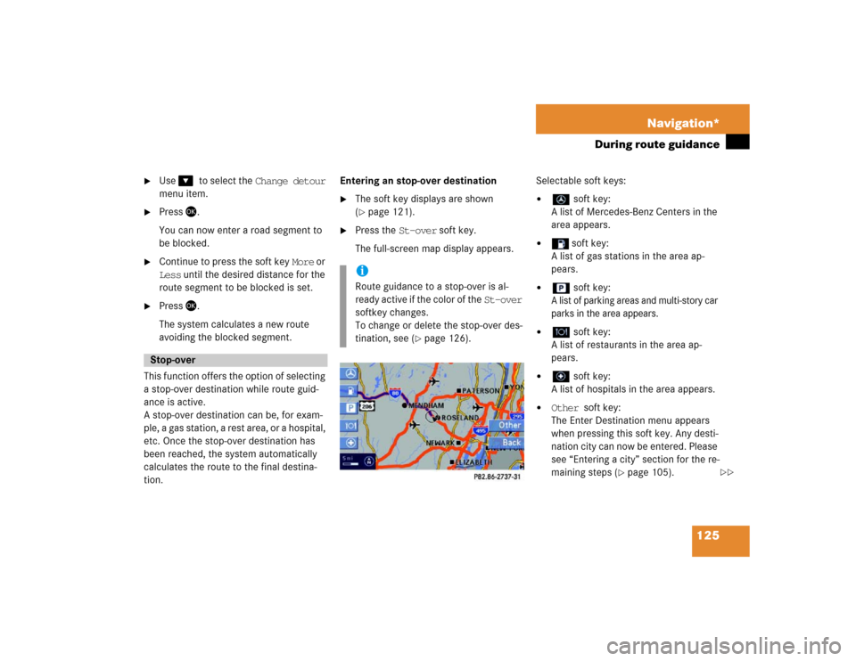
tion.Entering an stop-over destination
�
The soft key displays are shown
(�page 121).
�
Press the St-over soft key.
The full-screen map display appears.Selectable soft keys:
�
soft key:
A list of Mercedes-Benz Centers in the
area appears.
�
soft key:
A list of gas stations in the area ap-
pears.
�
soft key:
A list of parking areas and multi-story car
parks in the area appears.
�
soft key:
A list of restaurants in the area ap-
pears.
�
soft key:
A list of hospitals in the area appears.
�
Other soft key:
The Enter Destination menu appears
when pressing this soft key. Any desti-
nation city can now be entered. Please
see “Entering a city” section for the re-
maining steps (
�page 105).
Stop-over
iRoute guidance to a stop-over is al-
ready active if the color of the St-over
softkey changes.
To change or delete the stop-over des-
tination, see (
�page 126).
��
Page 127 of 168
126 Navigation*During route guidance�
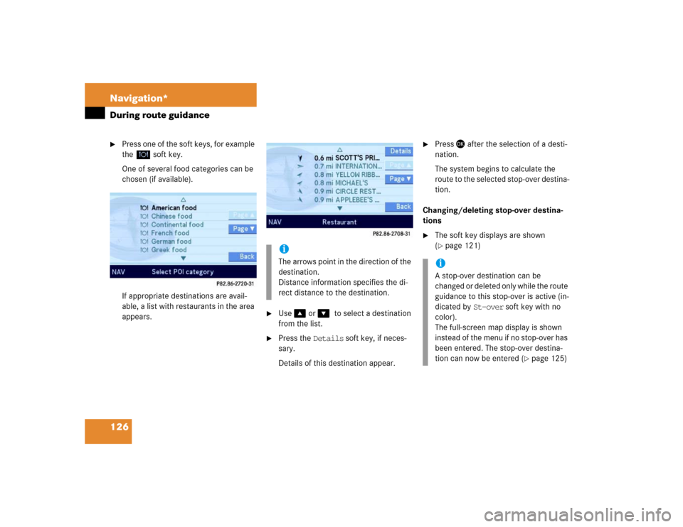
Press one of the soft keys, for example
the soft key.
One of several food categories can be
chosen (if available).
If appropriate destinations are avail-
able, a list with restaurants in the area
appears.
�
Use � or ��to select a destination
from the list.
�
Press the Details soft key, if neces-
sary.
Details of this destination appear.
�
Press � after the selection of a desti-
nation.
The system begins to calculate the
route to the selected stop-over destina-
tion.
Changing/deleting stop-over destina-
tions
�
The soft key displays are shown
(�page 121)
.
iThe arrows point in the direction of the
destination.
Distance information specifies the di-
rect distance to the destination.
iA stop-over destination can be
changed or deleted only while the route
guidance to this stop-over is active (in-
dicated by St-over soft key with no
color).
The full-screen map display is shown
instead of the menu if no stop-over has
been entered. The stop-over destina-
tion can now be entered (
�page 125)
Page 128 of 168
127 Navigation*
During route guidance
�
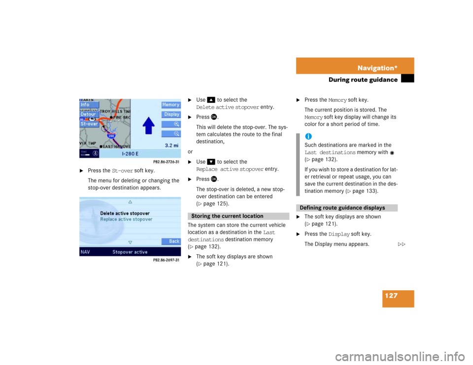
Press the St-over soft key.
The menu for deleting or changing the
stop-over destination appears.
�
Use� to select the
Delete active stopover entry.
�
Press �.
This will delete the stop-over. The sys-
tem calculates the route to the final
destination,
or
�
Use� to select the
Replace active stopover entry.
�
Press �.
The stop-over is deleted, a new stop-
over destination can be entered
(�page 125).
The system can store the current vehicle
location as a destination in the Last
destinations destination memory
(
�page 132).
�
The soft key displays are shown
(�page 121).
�
Press the Memory soft key.
The current position is stored. The
Memory soft key display will change its
color for a short period of time.
�
The soft key displays are shown
(�page 121).
�
Press the Display soft key.
The Display menu appears.
Storing the current location
iSuch destinations are marked in the
Last destinations memory with
(�page 132).
If you wish to store a destination for lat-
er retrieval or repeat usage, you can
save the current destination in the des-
tination memory (
�page 133).
Defining route guidance displays
��
Page 129 of 168
128 Navigation*During route guidanceSelectable soft keys:�
Symbols soft key:
Allows access to setting the symbols
display (
�page 128).
�
View soft key:
Allows access to setting the map orien-
tation (
�page 129).
�
GPS soft key:
Allows access to the Position Display
menu (
�page 130).
�
Auto soft key:
Allows access to the Automatic Map
Switching menu (
�page 130).
�
Zoom soft key:
Allows access to the definition of the
scales for full-screen and split-screen
map display (
�page 131).
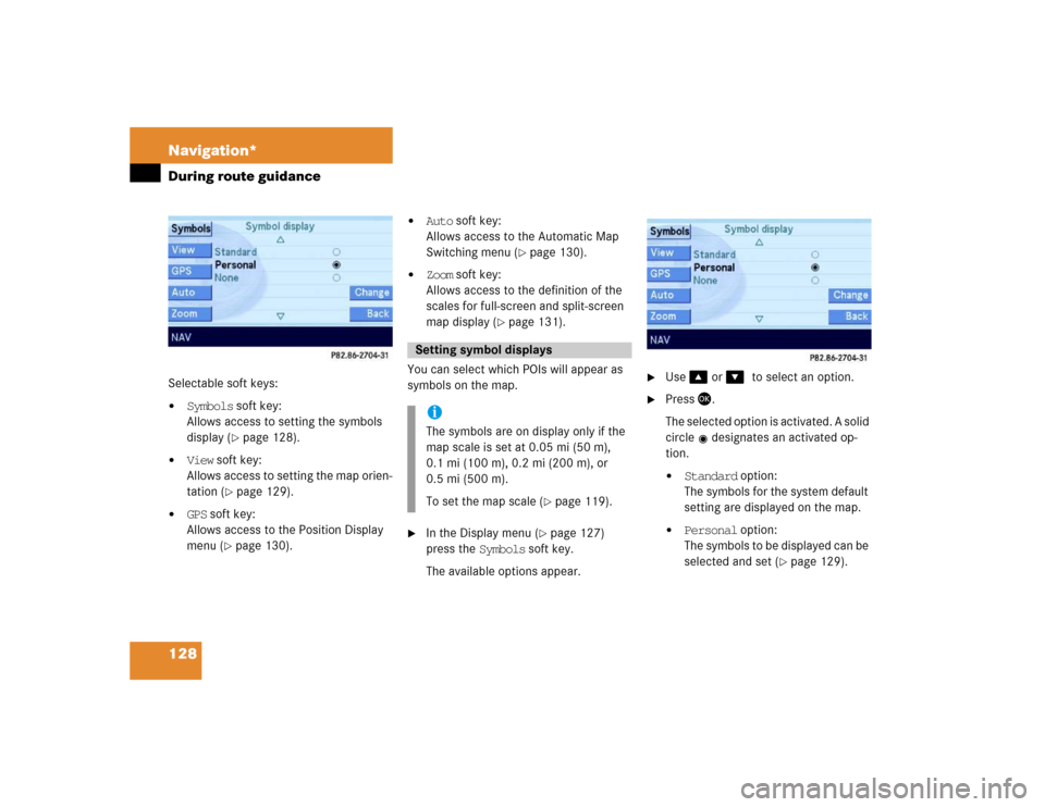
You can select which POIs will appear as
symbols on the map.
�
In the Display menu (
�page 127)
press the Symbols soft key.
The available options appear.
�
Use � or ��to select an option.
�
Press�.
The selected option is activated. A solid
circle designates an activated op-
tion.�
Standard option:
The symbols for the system default
setting are displayed on the map.
�
Personal option:
The symbols to be displayed can be
selected and set (
�page 129).
Setting symbol displays iThe symbols are on display only if the
map scale is set at 0.05 mi (50 m),
0.1 mi (100 m), 0.2 mi (200 m), or
0.5 mi (500 m).
To set the map scale (
�page 119).
Page 130 of 168

129 Navigation*
During route guidance
�
None option:
No symbols will be displayed on the
map.
Setting personal symbol display
�
After activating the Personal option,
press the Change soft key.
The list of available symbols will
appear.
�
Use � or ��to select a list entry.
�
Press �.
Activate or deactivate the symbol de-
pending on its previous state. Several
symbols can be activated.
�
Finally, press the Back soft key.
The setting is stored.
One of the following orientations can be
selected:
�
2D North up
Fixed map orientation, north is always
pointing up,
�
2D Heading up
Dynamic map orientation, driving direc-
tion is always pointing up.
�
In the Display menu (
�page 127),
press the View soft key.
Both options appear.Changing map orientation
�
Use � or ��to select the deactivat-
ed option.
�
Press�.
The orientation changes.
�
Finally, press the Back soft key.
iThe Change soft key is available, only if
the Personal option is selected. In
both other cases it will appear shaded
out.iEmpty square = symbol deactivated
Solid square = symbol activated
Setting map orientation
iEmpty circle = deactivated
Solid circle = activated
��
Page 131 of 168
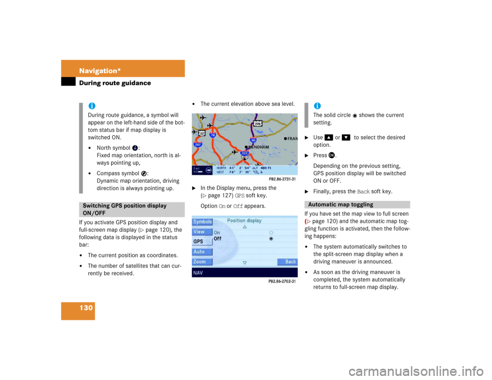
130 Navigation*During route guidanceIf you activate GPS position display and
full-screen map display (
�page 120), the
following data is displayed in the status
bar:
�
The current position as coordinates.
�
The number of satellites that can cur-
rently be received.
�
The current elevation above sea level.
�
In the Display menu, press the
(�page 127) GPS soft key.
Option On or Off appears.
�
Use � or ��to select the desired
option.
�
Press �.
Depending on the previous setting,
GPS position display will be switched
ON or OFF.
�
Finally, press the Back soft key.
If you have set the map view to full screen
(
�page 120) and the automatic map tog-
gling function is activated, then the follow-
ing happens:
�
The system automatically switches to
the split-screen map display when a
driving maneuver is announced.
�
As soon as the driving maneuver is
completed, the system automatically
returns to full-screen map display.
iDuring route guidance, a symbol will
appear on the left-hand side of the bot-
tom status bar if map display is
switched ON.�
North symbol :
Fixed map orientation, north is al-
ways pointing up,
�
Compass symbol :
Dynamic map orientation, driving
direction is always pointing up.
Switching GPS position display
ON/OFF
iThe solid circle shows the current
setting.Automatic map toggling
Page 132 of 168

131 Navigation*
During route guidance
Switching automatic toggling ON/OFF �
In the Display menu, press the
(�page 127) Auto soft key.
Option On and Off appears.
�
Use � or ��to select the desired
option.
�
Press �.Depending on the previous setting, au-
tomatic map toggling will be switched
ON or OFF.
�
Finally, press the Back soft key.
You can select whether the full-screen and
split-screen map scales are to be set to-
gether (default setting) or individually.
�
In the Display menu, press the
(�page 127) Zoom soft key.
The Default setting and Manual op-
tions appear.
�
Default setting option:
The scales for full-screen and split-
screen map display are always
identical. Changing the scale
(�page 119) on one map likewise
changes the scale of the other map.
�
Manual option:
The scales can be different. Chang-
ing the scale on one map has no ef-
fect on the current scale of the
other map.
�
Use � or � to select the desired op-
tion.
�
Press �.
Depending on the previous setting, the
Default setting (identical scale) or
Manual (individual scale) option is acti-
vated.
�
Finally, press the Back soft key.
iThe solid circle shows the current
setting.
Scales for full-screen and
split-screen map display
iThe solid circle shows the current
setting.
Page 133 of 168

132 Navigation*Last destinations and destination memoryThe Last destinations memory auto-
matically stores the last destination for
which route guidance had been started. A
maximum of 50 destinations can be
stored.
The current vehicle position can also be
stored as a destination in this memory
(�page 101 or 127). Such destinations
are marked with the symbol.
Retrieving last destinations
�
Call up the Navigation main menu
(�page 98).
�
Use� to select the Last
destinations menu item.
�
Press �.
The list of last destinations is dis-
played. The most recently stored desti-
nation is at the top of the list.Selecting a destination from the last
destinations memory
�
Retrieve the last destinations
(�page 132).
�
Use� or � to select an entry.
The Page soft keys allow scrolling
through the list page by page.The following options are now available:
�
Start route guidance to the selected
entry (
�page 133).
�
Delete the selected entry
(�page 133).
�
Store the selected entry in the destina-
tion memory:�
Press the Save soft key for this pur-
pose.
Refer to “Saving a destination in the
destination memory” section
(�page 133) for the remaining
steps.
�
Display of details on the selected entry
(if available):�
Press the Details soft key for this
purpose.
Last destinations memory