2004 FIAT MULTIPLA sat nav
[x] Cancel search: sat navPage 76 of 202
75
CONNECT NAV
NAVIGATOR
SELECTING NEXT/PREVIOUS TRACKS ...................... 110
SCANNING TRACKS ........................................................ 111
MIX FUNCTION ................................................................ 111
SCAN FUNCTION .............................................................. 112
REPEAT FUNCTION .......................................................... 112
PROGRAM FUNCTION .................................................... 113
CD NAME FUNCTION ...................................................... 115
SATELLITE NAVIGATION.......................................... 117
ROUTE GUIDANCE .......................................................... 117
ENTERING THE DESTINATION .................................. 118
ENTERING SPECIAL DESTINATIONS ........................ 125
USING STORED DESTINATIONS ................................ 128
STORING THE CURRENT POSITION ........................ 129
ACTIVE NAVIGATION .................................................. 130
ROUTE GUIDANCE .......................................................... 130
STOPPING NAVIGATION .............................................. 131
CHANGING THE AUDIO SOURCE ............................ 132
TUNING THE RADIO ...................................................... 132
NO MAP NAVIGATION .................................................. 132
DYNAMIC TRAVEL GUIDE ............................................ 133
TOURIST GUIDE INFORMATION ................................ 134
ROUTE LIST .......................................................................... 135
DESTINATION MEMORY ................................................ 135
STORING STORED DESTINATIONS .......................... 136
DELETING STORED DATA ............................................ 137ENTERING AND EDITING DESTINATION
SHORT NAMES .................................................................... 138
GPS STATUS AND POSITION INFORMATION ...... 139
AVOIDING TAILBACKS DURING NAVIGATION .. 139
LOCKING A ROUTE SECTION WITHIN
A ROUTE LIST ...................................................................... 140
CUSTOMISING THE ROUTE .......................................... 142
DEFINING THE CAR POSITION .................................. 143
RECEIVING TRAFFIC ANNOUNCEMENTS
DURING NAVIGATION .................................................. 144
SWITCHING VOICE MESSAGES ON AND OFF ...... 145
SWITCHING THE LAST 10 DESTINATION
MEMORY ON AND OFF .................................................. 145
SWITCHING ROUTE TIME
INFORMATION ON AND OFF .................................... 146
MANUAL POSITION INDICATION ............................ 146
NAVIGATION SIMULATION .......................................... 147
TARGA INFOMOBILITY SERVICES........................ 148
GENERAL INFORMATION .............................................. 148
ENABLING PHONE/SIM CARD ...................................... 149
ENTERING THE TARGA INFOMOBILITY NUMBER 150
ENTERING THE PERSONAL NUMBER ........................ 151
RESET ...................................................................................... 152
CONNECT NAV USE ........................................................ 152
“MEDICAL ADVICE” SERVICE ........................................ 153
“ROAD ASSISTANCE” SERVICE...................................... 155
INFOMOBILITY SERVICES .............................................. 156
Page 77 of 202

76
CONNECT NAV
NAVIGATOR
“FOLLOW ME” FUNCTION ............................................ 157
RECALLING THE PHONE CODE NUMBER .............. 162
RECALLING THE PHONE “STATE” FUNCTION .... 162
DISPLAYING AVAILABLE SIM PROFILES .................... 163
TELEPHONE.......................................................................... 164
GENERAL INFORMATION .............................................. 164
TURNING THE PHONE ON .......................................... 164
ENTERING THE PIN CODE ............................................ 164
CHANGING THE PIN CODE ........................................ 165
SIM CARD UNLOCKING ................................................ 166
VOLUME ADJUSTMENT .................................................. 166
SELECTING PHONE NUMBERS .................................... 167
SELECTING A NUMBER
IN THE PHONE BOOK .................................................... 169
INCOMING CALLS ............................................................ 170
TELEPHONE CALLS TO FOREIGN COUNTRIES .... 171
SELECTING THE NETWORK ........................................ 172
PHONEBOOK ...................................................................... 176
MESSAGES (SMS) ................................................................ 178BASIC SETTINGS .............................................................. 183
OPENING THE SETTINGS MENU ................................ 183
ADJUSTING THE DISPLAY .............................................. 183
ADJUSTING POWER-ON, TA ANNOUNCEMENT
MESSAGE ................................................................................ 185
SETTING THE CLOCK ...................................................... 187
SELECTING THE LANGUAGE ........................................ 189
GPS STATUS ........................................................................ 190
SECURITY .............................................................................. 191
RESETTING DEFAULT SETTINGS ................................ 192
ANTITHEFT PROTECTION SYSTEM.................. 195
GENERAL INFORMATION .............................................. 195
CODE CARD ........................................................................ 195
ENTERING THE SECURITY CODE .............................. 195
TECHNICAL DATA .......................................................... 197
RADIO .................................................................................... 197
COMPACT DISC PLAYER AND CD CHANGER .... 197
AUDIO .................................................................................... 198
SATELLITE NAVIGATION ................................................ 198
TARGA INFOMOBILITY SERVICES ................................ 198
TELEPHONE ........................................................................ 198
SYSTEM TECHNICAL DATA .......................................... 199
Page 118 of 202
117
CONNECT NAV
NAVIGATOR
S S
A A
T T
E E
L L
L L
I I
T T
E E
N N
A A
V V
I I
G G
A A
T T
I I
O O
N N
The system will help you reach desti-
nations rapidly and safely. After switch-
ing the navigation function on, voice
messages will guide you to your desti-
nation. Driving advice, distances and es-
timated time required to reach the des-
tination will be shown on the display.
The car’s position is defined on the
basis of the electronic speedometer
signal, of a gyroscope and of the sig-
nals transmitted by the GPS (Global
Positioning System) satellites.
The system compares the data
against the maps stored on the navi-
gation CD-ROM and calculates both
the position and the routes to reach
the destination.ROUTE GUIDANCE
Proceed as follows:
1) insert the CD ROM specific to the
country you are travelling in
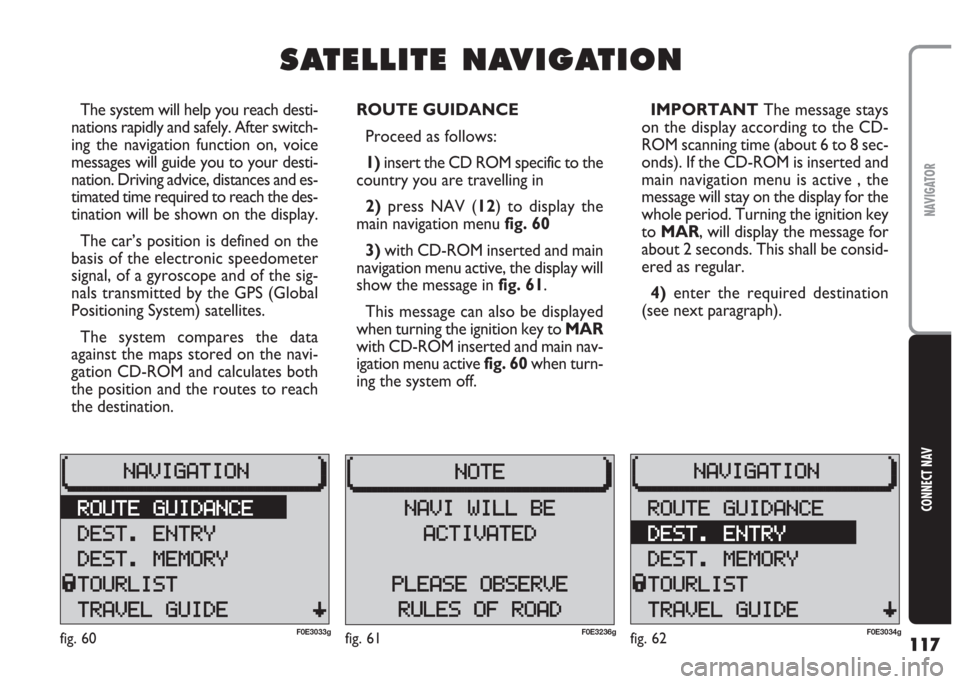
2)press NAV (12) to display the
main navigation menu fig. 60
3) with CD-ROM inserted and main
navigation menu active, the display will
show the message in fig. 61.
This message can also be displayed
when turning the ignition key to MAR
with CD-ROM inserted and main nav-
igation menu active fig. 60when turn-
ing the system off.IMPORTANT The message stays
on the display according to the CD-
ROM scanning time (about 6 to 8 sec-
onds). If the CD-ROM is inserted and
main navigation menu is active , the
message will stay on the display for the
whole period. Turning the ignition key
to MAR, will display the message for
about 2 seconds. This shall be consid-
ered as regular.
4) enter the required destination
(see next paragraph).
fig. 60F0E3033gfig. 62F0E3034gfig. 61F0E3236g
Page 131 of 202
130
CONNECT NAV
NAVIGATOR
ROUTE GUIDANCE
Active navigation requires an entered
destination (see “Entering the desti-
nation” in section “Satellite naviga-
tion”) and route options settings.
Proceed as follows:
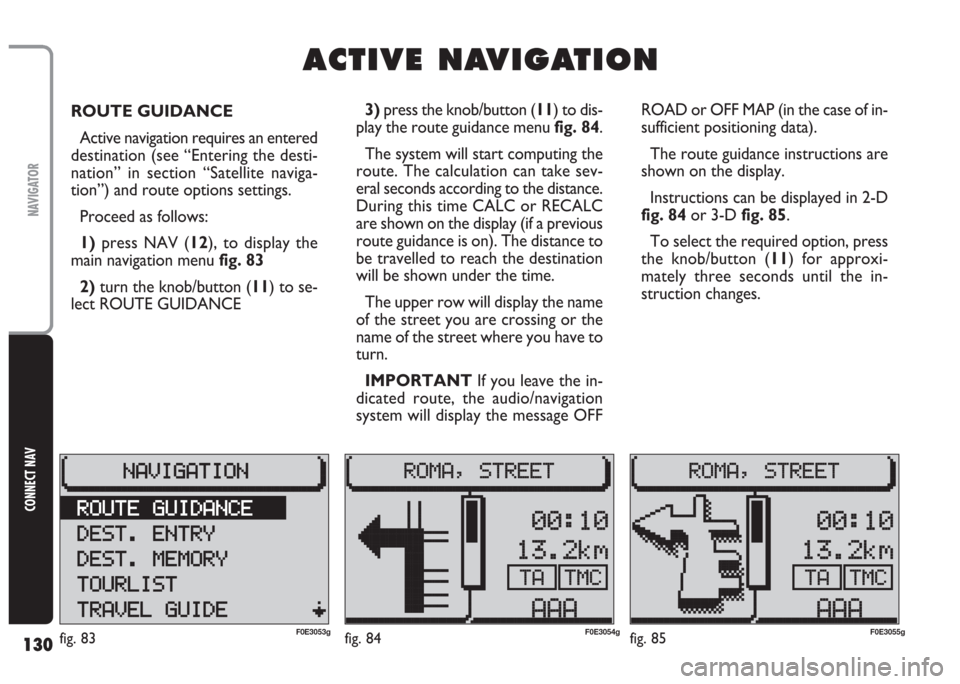
1) press NAV (12), to display the
main navigation menu fig. 83
2)turn the knob/button (11) to se-
lect ROUTE GUIDANCE ROAD or OFF MAP (in the case of in-
sufficient positioning data).
The route guidance instructions are
shown on the display.
Instructions can be displayed in 2-D
fig. 84or 3-D fig. 85.
To select the required option, press
the knob/button (11) for approxi-
mately three seconds until the in-
struction changes.
A A
C C
T T
I I
V V
E E
N N
A A
V V
I I
G G
A A
T T
I I
O O
N N
3) press the knob/button (11) to dis-
play the route guidance menu fig. 84.
The system will start computing the
route. The calculation can take sev-
eral seconds according to the distance.
During this time CALC or RECALC
are shown on the display (if a previous
route guidance is on). The distance to
be travelled to reach the destination
will be shown under the time.
The upper row will display the name
of the street you are crossing or the
name of the street where you have to
turn.
IMPORTANT If you leave the in-
dicated route, the audio/navigation
system will display the message OFF
fig. 83F0E3053gfig. 84F0E3054gfig. 85F0E3055g
Page 135 of 202
134
CONNECT NAV
NAVIGATOR
TOURIST GUIDE
INFORMATION
(where fitted)
Tourist information on the destina-
tions can be recalled when using a nav-
igation CD.
Information is contained in directo-
ries on the following topics: accom-
modation, restaurants, tourist infor-
mation, amusements, etc…
The guide name will appear in the
main navigation menu if there is only
one guide (e.g.: MERIAN scout).Proceed as follows:
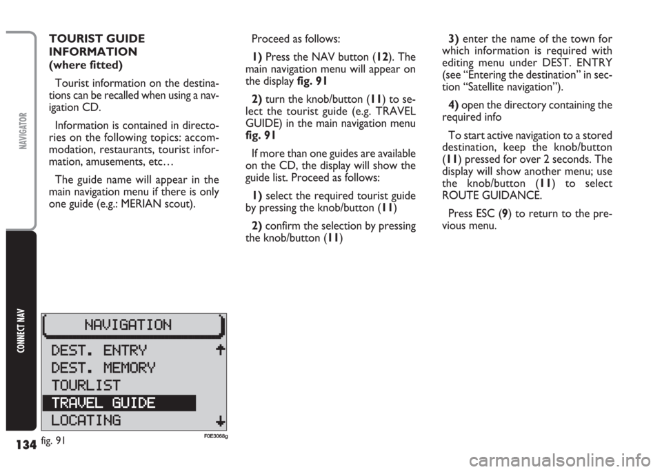
1) Press the NAV button (12). The
main navigation menu will appear on
the display fig. 91
2)turn the knob/button (11) to se-
lect the tourist guide (e.g. TRAVEL
GUIDE) in the main navigation menu
fig. 91
If more than one guides are available
on the CD, the display will show the
guide list. Proceed as follows:
1)select the required tourist guide
by pressing the knob/button (11)
2)confirm the selection by pressing
the knob/button (11)3)enter the name of the town for
which information is required with
editing menu under DEST. ENTRY
(see “Entering the destination” in sec-
tion “Satellite navigation”).
4)open the directory containing the
required info
To start active navigation to a stored
destination, keep the knob/button
(11) pressed for over 2 seconds. The
display will show another menu; use
the knob/button (11) to select
ROUTE GUIDANCE.
Press ESC (9) to return to the pre-
vious menu.
fig. 91F0E3068g
Page 140 of 202

139
CONNECT NAV
NAVIGATOR
GPS STATUS AND POSITION
INFORMATION
Proceed as follows to display the
number of GPS satellites which can be
received and the car position:
1) Press the NAV button (12). The
main navigation menu will appear on
the display
2) select GPS STATUS by turning the
knob/button (11)
3) confirm the selection by pressing
the knob/button (11).
Press ESC (9) to return to the pre-
vious menu.AVOIDING TAILBACKS
DURING NAVIGATION
When active navigation is on, the sys-
tem can detour tailbacks or road in-
terruptions.
IMPORTANT Only the options
for which data is available on the nav-
igation CD are offered. A lock symbol
Swill appear next to the unavailable
options.
Proceed as follows:
1)press T (8): the display will show
the TRAFFIC menu fig. 1012)turn the knob/button (11) to se-
lect TR. JAM FUNCT.
3)the display will show the SET-
TINGS menu fig. 102; use the
knob/button (11) to select TRAFFIC
AHEAD
4) press the knob/button (11) to
confirm; the display will show the
TRAFFIC AHEAD menu and the cur-
sor will move to TO fig. 103
5)press knob/button (11)
6) position the cursor on FROM
with the knob/button (11)
fig. 101F0E3215gfig. 102F0E3064g
Page 147 of 202
146
CONNECT NAV
NAVIGATOR
SWITCHING ROUTE TIME
INFORMATION ON AND OFF
This function enables to select the
time required to reach the destination
and the estimated and exact time of
arrival.
Proceed as follows to switch the
route time information on and off:
1)press MEN (10) the display will
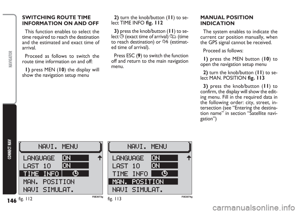
show the navigation setup menu2) turn the knob/button (11) to se-
lect TIME INFO fig. 112
3)press the knob/button (11) to se-
lect
X(exact time of arrival) Q(time
to reach destination) or R(estimat-
ed time of arrival).
Press ESC (9) to switch the function
off and return to the main navigation
menu.MANUAL POSITION
INDICATION
The system enables to indicate the
current car position manually, when
the GPS signal cannot be received.
Proceed as follows:
1)press the MEN button (10) to
open the navigation setup menu
2) turn the knob/button (11) to se-
lect MAN. POSITION fig. 113
3)press the knob/button (11) to
confirm, the display will show the edit-
ing menu. Fill in the required data in
the following order: city, street, in-
tersection (see “Entering the destina-
tion name” in section “Satellite navi-
gation”)
fig. 112F0E3073gfig. 113F0E3074g
Page 148 of 202
147
CONNECT NAV
NAVIGATOR
4)after completing the above oper-
ation, press the knob/button (11) for
over 2 seconds to confirm or select
symbol (
j) and confirm: the display will
show the main navigation menu.
IMPORTANT Certain road inter-
sections (e.g. straight road intersection
with loop road) are not suitable for in-
dicating the car position. NAVIGATION SIMULATION
The system can simulate a trip. The
system simulates navigation by pro-
viding realistic visual instructions, voice
messages and acoustic signals.
Proceed as follows to start a simu-
lation:
1)press the MEN button (10) to
open the navigation setup menu
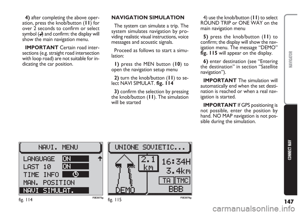
2) turn the knob/button (11) to se-
lect NAVI SIMULAT. fig. 114
3)confirm the selection by pressing
the knob/button (11). The simulation
will be started4) use the knob/button (11) to select
ROUND TRIP or ONE WAY on the
main navigation menu
5) press the knob/button (11) to
confirm; the display will show the nav-
igation menu. The message “DEMO”
fig. 115 will appear on the display.
6)enter destination (see “Entering
the destination” in section “Satellite
navigation”).
IMPORTANT The simulation will
automatically end when the set desti-
nation is reached or when a real nav-
igation is started.
IMPORTANT If GPS positioning is
not possible, enter the position by
hand. NO MAP navigation is not pos-
sible during the simulation.
fig. 114F0E3075gfig. 115F0E3076g