Page 150 of 226

142 NavigationDestination inputSelecting a route mode P
1Route calculated for optimum driving
time
2Route calculated for optimum driving
route�
Turn the right-hand rotary/push-
button v to highlight the desired route
mode and press to confirm.Including P or avoiding Q traffic rou-
tes, several selections are available
3Calculate the route with/without free-
ways
4Calculate the route with/without ferry
connections, car trains
5Calculate the route with/without toll
roads
6COMAND calculates the route with the
selected settings
�
Turn the right-hand rotary/push-
button v to highlight the desired type
of road and press the button.Calculating the route
�
Press the right-hand rotary/push-
button v longer than 2 seconds.
or
�
Turn the right-hand rotary/push-
button v to highlight “OK” and press
to confirm.
As soon as calculation begins, you will
see a corresponding message and hear
the voice output “The route is being
calculated”.
iToll roads appear in green on the map.
iIn the event that no reasonable alterna-
te route for that destination exists,
COMAND will calculate the route inclu-
ding 3 to 5 even if these selections
are to be avoided.
Page 166 of 226
158 NavigationRoute guidanceActivating the scale selector�
Press + or ,.
or
�
Turn the right-hand rotary/push-
button v to highlight 1 and press to
confirm.
The scale selector will appear.
1Current map scale
2Scale selector
3New map scale
Zooming in for more detailed map
�
Press +.
or
�
Turn the right-hand rotary/push-
button v to the left.
The map will appear automatically.Zooming out for less detailed map
�
Press ,.
or
�
Turn the right-hand rotary/push-
button v to the right.
The map will appear automatically.
Altering the map scaleiA division mark corresponds to an avai-
lable scale. You can select 13 different
scales ranging from 0.05 miles/inch to
500 miles/inch.
Page 171 of 226
163 Navigation
Route guidance
Main detour menu
1It is possible to block route sections
ahead
2Ends the detour function, the previous
route is calculated
3It is possible to block route sections in
the route list (
�page 165)
Explanation corresponding 2
�
Detour has not yet been selected
You cannot select “Cancel”
�
Detour has been selected
“Cancel” is highlighted
�
Press ) while any menu is on the
screen during route guidance.
The main detour menu will appear.
�
Turn the right-hand rotary/push-
button v to highlight the desired
menu field and press the button.
^
Selecting a detour
P82.85-9222-31
1223
iTraffic jams are identified by the driver,
not by the COMAND.
If you switch off COMAND for more than
30 minutes during active route
guidance, all manually entered traffic
jams are deleted.
Page 174 of 226

166 NavigationRoute guidanceCalling detailed route list Detailed route list4Symbol “-” - sections of a road are dis-
played�
Press +.
The detailed route list will appear.Blocking off several streets/street sec-
tions
�
Turn the right-hand rotary/push-
button v to the right.
With each turn, you will block another
section.
The road name will appear in red.
Undoing street block
�
Turn the right-hand rotary/push-
button v to the left.
The street name will appear in black
again.
Switching back to the route list
�
Press ,.
The symbol “+” appears in front of the
street section.
The blocking function is still active.Canceling blocking function, do not recal-
culate the route
�
Press *.
The traffic jam menu will appear.
Ending the blocking function, re-calcula-
ting the route with the blocks selected
�
Press the right-hand rotary/push-
button v.
COMAND re-calculates the route in the
previously selected calculation mode.
A corresponding message will appear.
Then the symbol display will appear
again and COMAND will continue route
guidance.
Page 175 of 226
167 Navigation
Route guidance
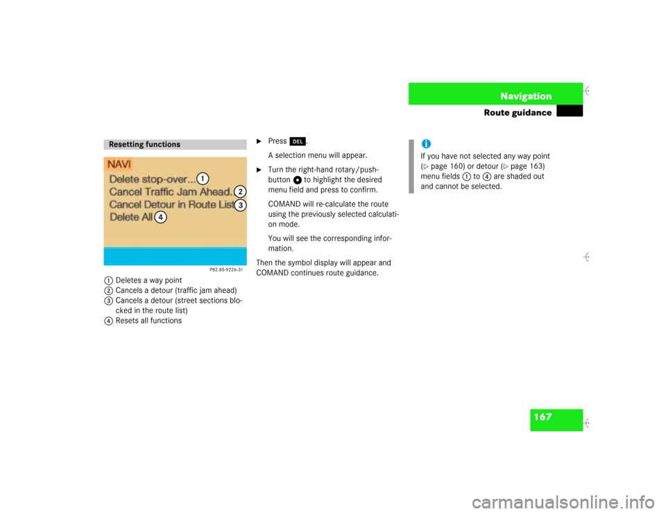
1Deletes a way point
2Cancels a detour (traffic jam ahead)
3Cancels a detour (street sections blo-
cked in the route list)
4Resets all functions
�
Press r.
A selection menu will appear.
�
Turn the right-hand rotary/push-
button v to highlight the desired
menu field and press to confirm.
COMAND will re-calculate the route
using the previously selected calculati-
on mode.
You will see the corresponding infor-
mation.
Then the symbol display will appear and
COMAND continues route guidance.
Resetting functions
iIf you have not selected any way point
(�page 160) or detour (
�page 163)
menu fields 1 to 4 are shaded out
and cannot be selected.
Page 179 of 226
 you can select another
COMAND system by pressing the corres-
ponding key.
The main menu of the selected au")
171 Navigation
Route guidance
During route guidance (you see either sym-
bol or map display) you can select another
COMAND system by pressing the corres-
ponding key.
The main menu of the selected audio sour-
ce will appear and you will e.g. hear the
radio.
Route guidance and the navigation’s voice
output remain active.
The voice output is added to the audio
playback.
You can individually adjust the volume le-
vels for voice output and audio playback
(�page 64).
�
Press c.
The main radio menu will appear. The
station last tuned to will begin to play.
�
Selecting a station (
�page 30).
Returning to navigation system
�
Press b.During route guidance, you can operate an
audio source that is active in the back-
ground. Although the options are limited,
you can operate the audio source without
having to fully switch to the corresponding
system.
1A window is shown in the symbol or
map display, providing details about
the active audio source
Activating audio system
P82.85-
9230-31
Activating audio functions
Page 180 of 226
172 NavigationRoute guidanceRemoving the window
This is done automatically after 3 seconds.
or�
Press *.
The radio is active
�
Selecting a memorized station from the
respective memory (FM, AM or WB)�
Press number keys 1 through 0.
�
Performing station seek�
Press g or h briefly.
�
Starting manual search�
Press g or h longer than
2 seconds.
The search run will start in the desi-
red direction - frequency ranges
FM, AM or WB.CD mode is active
�
Select CD with number keys
0 CD drive
1 - 6 CD changer
�
Selecting previous/next track�
Press g or h briefly.
�
Skip backwards/forwards�
Hold g or h longer than
2 seconds.
Page 188 of 226

180 NavigationSettings
� SettingsCOMAND normally determines the vehicle
location automatically with the GPS. In ex-
ceptional cases, this may not be possible.
You can then enter the current vehicle lo-
cation manually in connection with a
crossroad.�
Turn the right-hand rotary/push-
button v to highlight “Settings” in the
main destination input menu and press
to confirm.
�
Turn the right-hand rotary/push-
button v to highlight “Location...” and
press to confirm.
The input menu to enter the city will ap-
pear.
�
Enter the city/suburb and then the
street and select the required entries
from the corresponding list. See “Ente-
ring destination address”
(�page 123).
After you have selected the street, you will
see a prompt for the intersection.
�
Turn the right-hand rotary/push-
button v to highlight the appropriate
cross street and press to confirm.
The input menu “Location/Intersec-
tion” will appear.
Location is ahead or behind an intersection�
Turn the right-hand rotary/push-
button v to the right (location is
ahead) or to the left (location is behind)
and press to confirm.
The message “Chosen location accep-
ted” will appear.
�
Press the right-hand rotary/push-
button v to confirm.
Entering the vehicle location