Page 150 of 251
148
Destination input
Audio TelephoneNavigation
Index Info Services and
system settings Introduction
Navigation
Switching the navigation system on
Press
.
The following message will appear when COMAND is
preparing for navigation startup: “Activating
Navigation. Please obey all traffic rules”.One of four displays will appear:
• the main destination input menu, for active destina-
tion entry (illustrated above)
• the map display, page 178
when route guidance and the map were previously
active and route was not completed
• the symbol display indicating turns, page 178
when route guidance and the symbol display were
previously active and route was not completed.
• the location map, page 184
P82.85-6097-26
P82.85-6098-26
09-NAVI1-25-US.pm509.07.2004, 14:25 Uhr 148
Page 151 of 251

149 Destination input
Introduction
Audio
Telephone
Navigation
Index Info Services and
system settings
NavigationNote:
When navigation is preparing for operation, various
error messages may appear:
• “Navigation cannot be activated. An error has
occurred.”
• “CD-Reading error. Please change CD” – remove the
current CD and insert the Navigation CD.
• “No CD. Please insert NAVI-CD type DX only” – you
did not insert a CD, insert the Navigation CD type
DX. Please use only a current navigation CD. A
navigation CD from an older model may not be
compatible and may cause an error message to be
displayed.
When the error has been corrected COMAND shows the
message “Activating Navigation. Please obey all traffic
rules”.
To change over to another system press the
corresponding key, e.g.
.Changing the Navigation CD
Press
to eject an inserted navigation CD.
Insert another navigation CD.
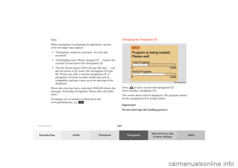
The screen above will be displayed. The program stored
on the navigation CD is being loaded.
Important!
Do not interrupt the loading process.
P82.85-6094-26
09-NAVI1-25-US.pm509.07.2004, 14:25 Uhr 149
Page 157 of 251
155 Destination input
Introduction
Audio
Telephone
Navigation
Index Info Services and
system settings
P82.85-2597-26
1312
11
To access the list of places:
Press the rotary/pushbutton
for longer than
2 seconds or highlight and confirm menu field (10).
11Selected City/Suburb, already highlighted
12Display to previous page
13Display to next pageThe next/previous page can be reached by turning the
rotary/pushbutton
past the last/first entry.
Turn the rotary/pushbutton
to highlight the desired
destination and press it to confirm.
09-NAVI1-25-US.pm509.07.2004, 14:26 Uhr 155
Page 168 of 251

166
Destination input
Audio TelephoneNavigation
Index Info Services and
system settings Introduction
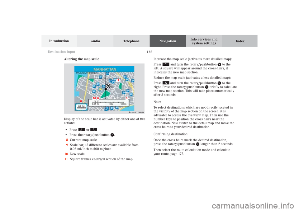
Altering the map scale
Display of the scale bar is activated by either one of two
actions:
• Press
or
• Press the rotary/pushbutton
.
8Current map scale
9Scale bar, 13 different scales are available from
0.05 mi/inch to 500 mi/inch
10New scale
11Square frames enlarged section of the mapIncrease the map scale (activates more detailed map):
Press
and turn the rotary/pushbutton
to the
left. A square will appear around the cross-hairs, it
indicates the new map section.
Reduce the map scale (activates a less detailed map):
Press
and turn the rotary/pushbutton
to the
right. Press the rotary/pushbutton
briefly to calculate
the new map section. This will take place automatically
after 8 seconds.
Note:
To select destinations which are not directly located in
the vicinity of the map section on the screen, it is
advisable to access the overview map. Then use the
number keys to position the cross hairs near the
destination. Now switch to the detail map and move the
cross hairs to your desired destination.
Confirming destination:
Once the cross hairs mark the desired destination,
press the rotary/pushbutton
longer than 2 seconds.
Then select the route calculation mode and calculate
your route, page 175.
P82.85-7739-26
11
10
8
8
9
09-NAVI1-25-US.pm509.07.2004, 14:27 Uhr 166
Page 172 of 251

170
Destination input
Audio TelephoneNavigation
Index Info Services and
system settings Introduction
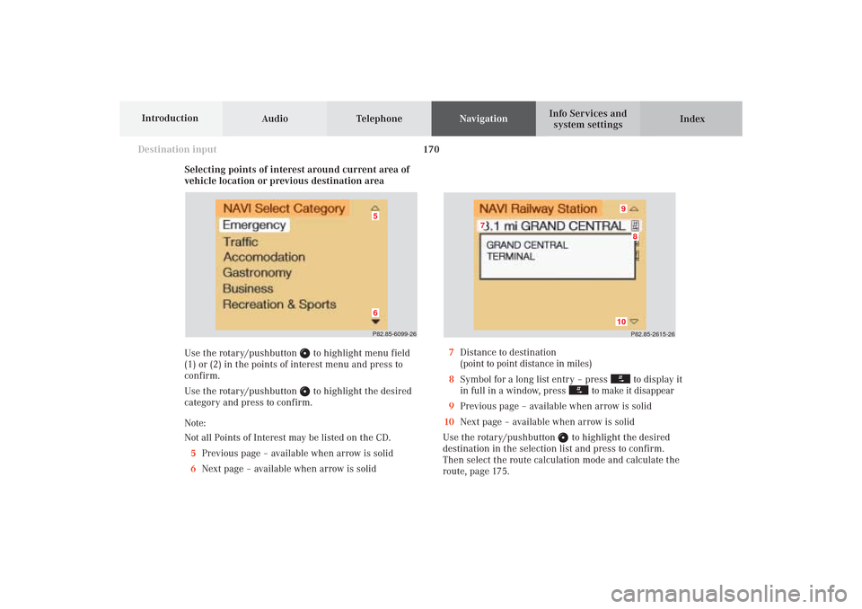
Selecting points of interest around current area of
vehicle location or previous destination area
Use the rotary/pushbutton
to highlight menu field
(1) or (2) in the points of interest menu and press to
confirm.
Use the rotary/pushbutton to highlight the desired
category and press to confirm.
Note:
Not all Points of Interest may be listed on the CD.
5Previous page – available when arrow is solid
6Next page – available when arrow is solid
P82.85-2615-26
10
8
7
9
7Distance to destination
(point to point distance in miles)
8Symbol for a long list entry – press
to display it
in full in a window, press
to make it disappear
9Previous page – available when arrow is solid
10Next page – available when arrow is solid
Use the rotary/pushbutton
to highlight the desired
destination in the selection list and press to confirm.
Then select the route calculation mode and calculate the
route, page 175.
P82.85-6099-2665
09-NAVI1-25-US.pm509.07.2004, 14:27 Uhr 170
Page 176 of 251
174
Destination input
Audio TelephoneNavigation
Index Info Services and
system settings Introduction
Selecting the last destinations
Use the rotary/pushbutton
to highlight the “Last
destinations” menu field in the main destination input
menu and press to confirm.
A list will be activated. The last 12 destinations entered
will be displayed.Use the rotary/pushbutton
to highlight the desired
destination and press it to confirm your selection.
The route mode menu will appear.
Select the route calculation mode and calculate the
route, page 175.
P82.85-6102-26
09-NAVI1-25-US.pm509.07.2004, 14:28 Uhr 174
Page 179 of 251
177 Destination input
Introduction
Audio
Telephone
Navigation
Index Info Services and
system settings
Calculate the route
P82.85-2604-26
After a few seconds, the symbol display will appear:
9The driving route is being calculated,
other messages may also appear here during route
guidance, page 179
10Arrow indicating the direction to the destination
(point to point distance),
may also by displayed briefly during route guid-
ance, e.g. if you are driving on roads/road sections
that are not stored on the Navigation CD.
11Distance to the destination (point to point distance)
P82.85-6105-26
10
11
9
The arrow indicating your driving direction will appear
when the COMAND system has identified the road you
are travelling on.
You will hear a message, such as “Please, turn next
right”.
How route guidance works, page 178.
09-NAVI1-25-US.pm509.07.2004, 14:28 Uhr 177
Page 181 of 251

179
Route guidance
Introduction
Audio Telephone
Navigation
Index Info Services and
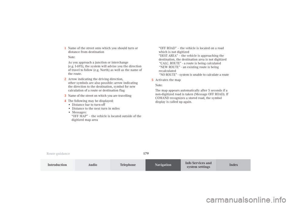
system settings 1Name of the street onto which you should turn or
distance from destination
Note:
As you approach a junction or interchange
(e.g. I-695), the system will advise you the direction
of travel to follow (e.g. North) as well as the name of
the route.
2Arrow indicating the driving direction,
other symbols are also possible: arrow indicating
the direction to the destination, symbol for new
calculation of a route or destination f lag
3Name of the street on which you are travelling
4The following may be displayed:
• Distance bar to turn-off
• Distance to the next turn in miles
• Messages:
“OFF MAP” – the vehicle is located outside of the
digitized map area“OFF ROAD” – the vehicle is located on a road
which is not digitized
“DEST AREA” – the vehicle is approaching the
destination, the destination area is not digitized
“CALC. ROUTE” - a route is being calculated
“NEW ROUTE” - an existing route is being
recalculated
“NO ROUTE” - system is unable to calculate a route
5Activates the map
Note:
The map appears automatically after 5 seconds if a
non-digitized road is taken (Message OFF ROAD). If
COMAND recognizes a stored road, the symbol
display is called up again.
10-NAVI2-25-US.pm517.10.2001, 10:42 Uhr 179