Page 159 of 243
157
Introduction
Audio
Telephone
Navigation
Index Info Services and
system settings Destination input
P82.85-2600-2624
2526
24The street entered is highlighted
Call up next/previous page – use the rotary/pushbutton
to highlight symbol (25, 26) and continue to move in
the corresponding direction:
25Previous page
26Next page
Turn the rotary/pushbutton
to highlight the desired
street and press to confirm.
Press the rotary/pushbutton
for longer than
2 seconds or highlight and confirm menu field (23).
If the street you select is saved on the CD more than
once, a menu will appear for you to select the
corresponding suburb of entered city.
Page 164 of 243
162
Index Info Services and
system settings IntroductionAudio TelephoneNavigation
Destination input
Moving the cross hairs
4Street name or the name of the symbol (e.g. parking
area/ -garage) that the cross hairs are centered on
5Cross hairs to select the destination
6Symbol for current vehicle location
7Current map scale
During destination entry, the map will always appear
facing north (north is up). The appearance of the map is
dependent on the scale.
P82.85-3016-26
7
6
5
4
Use the number keys
through
,
through
according to the corresponding arrows to move
the cross hairs arround the map:– Move to the top left– Move up– Move to the top right– Move to the left– Move to the right
P82.85-3017-26
Page 169 of 243
167
Introduction
Audio
Telephone
Navigation
Index Info Services and
system settings Destination inputSelecting points of interest in the area surrounding
another city
Use the rotary/pushbutton
to highlight the menu
field for “Select City ...” in the points of interest menu
and press to confirm.
Use the rotary/pushbutton to highlight the initial
letters of the desired city one after the other and press
to confirm.
Structure of the input menu, page 154.
Correcting the entry, page 154.
P82.85-2616-26
P82.85-2617-26
Activating the city list:
Press the rotary/pushbutton
longer than 2 seconds or
highlight the “City list” menu field and confirm.
Moving to the next/previous page:
Use the rotary/pushbutton to highlight the scrolling
symbol and turn in the corresponding direction or
confirm the symbol by pressing.
Turn the rotary/pushbutton to highlight the desired
destination and press to confirm.
Page 171 of 243
169
Introduction
Audio
Telephone
Navigation
Index Info Services and
system settings Destination input
P82.85-2620-26
P82.85-2621-26
Use the rotary/pushbutton
to highlight the letters of
the desired destination one after the other in the input
menu and press to confirm.
The input line will automatically be populated with the
first matching enry in the list. As subsequent charac-
ters are entered, the system will narrow the available
list.
Structure of the input menu, page 154.
Correcting the entry, page 154.Activating the list:
Press the rotary/pushbutton
longer than 2 seconds
or highlight the “List” menu field and confirm.
Moving to the next/previous page:
Use the rotary/pushbutton to highlight the scrolling
symbol and turn in the corresponding direction.
Turn the rotary/pushbutton to highlight the desired
destination and press to confirm.
Select the route calculation mode and calculate the
route, page 171.
Page 177 of 243

175
Introduction
Audio Telephone
Navigation
Index Info Services and
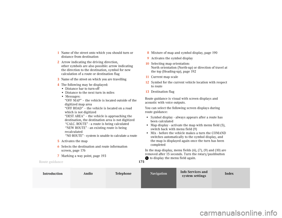
system settings Route guidance1Name of the street onto which you should turn or
distance from destination
2Arrow indicating the driving direction,
other symbols are also possible: arrow indicating
the direction to the destination, symbol for new
calculation of a route or destination flag
3Name of the street on which you are travelling
4The following may be displayed:
• Distance bar to turn-off
• Distance to the next turn in miles
• Messages:
“OFF MAP” – the vehicle is located outside of the
digitized map area
“OFF ROAD” – the vehicle is located on a road
which is not digitized
“DEST AREA” – the vehicle is approaching the
destination, the destination area is not digitized
“CALC. ROUTE” - a route is being calculated
“NEW ROUTE” - an existing route is being
recalculated
“NO ROUTE” - system is unable to calculate a route
5Activates the map
6Selects the destination and route information
screen, page 176
7Marking a way point, page 1938Mixture of map and symbol display, page 190
9Activates the symbol display
10Selecting map orientation:
North orientation (North-up) or direction of travel at
the top (Heading-up), page 192
11Current map scale
12Symbol for the current vehicle location with respect
to route
13Destination flag
Route guidance is visual with screen displays and
acoustic with voice outputs.
You can select the following screen displays during
route guidance:
• Symbol display - always appears after a route has
been calculated
• Map display - activate the map with menu field (5),
switch back with menu field (9)
• Mix - before the vehicle makes a turn the COMAND
switches automatically to the symbol display, and
the map is displayed again once the turn has been
completed
In the map display, menu fields (6), (7), (9) and (10) are
removed after 15 seconds. Turn the rotary/pushbutton
to display the menu field again.
Page 193 of 243
191
Introduction
Audio Telephone
Navigation
Index Info Services and
system settings Route guidanceIncrease the map scale (activate a more detailed map):
Press
and turn the rotary/pushbutton
to the left.
Reduce the map scale (activate a less detailed map):
Press
and turn the rotary/pushbutton
to the
right.
Note:
A division mark corresponds to an available scale.
There are 12 different scales ranging from 0.1 miles/
inch to 500 miles/inch.
P82.85-2638-26
3
2
1
1
P82.85-2639-26
Altering the map scale
To activate the scale bar (2), select one of the following
methods:
• Press
or
• Use the rotary/pushbutton
to highlight the scale
menu field (1) and confirm by pressing.
1Current map scale
2Scale bar
3New scale
Page 201 of 243

199
Introduction
Audio Telephone
Navigation
Index Info Services and
system settings Route guidance
P82.85-3062-26
8
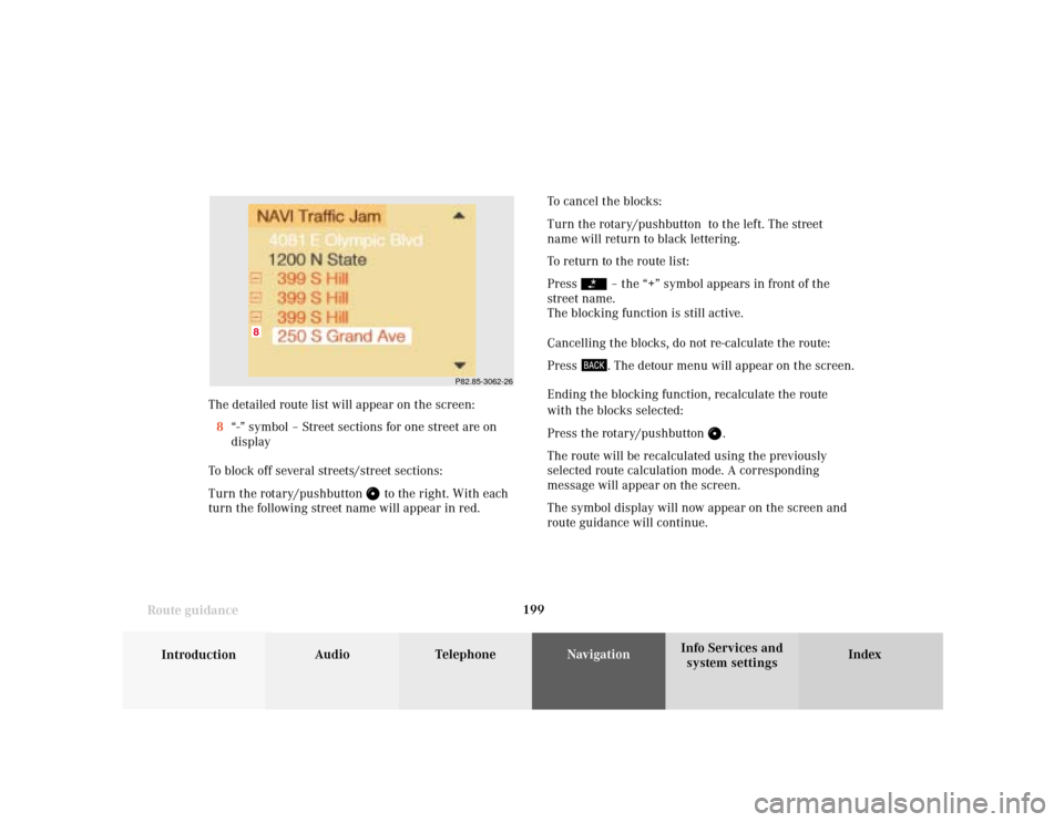
The detailed route list will appear on the screen:
8“-” symbol – Street sections for one street are on
display
To block off several streets/street sections:
Turn the rotary/pushbutton
to the right. With each
turn the following street name will appear in red.To cancel the blocks:
Turn the rotary/pushbutton to the left. The street
name will return to black lettering.
To return to the route list:
Press
– the “+” symbol appears in front of the
street name.
The blocking function is still active.
Cancelling the blocks, do not re-calculate the route:
Press . The detour menu will appear on the screen.
Ending the blocking function, recalculate the route
with the blocks selected:
Press the rotary/pushbutton
.
The route will be recalculated using the previously
selected route calculation mode. A corresponding
message will appear on the screen.
The symbol display will now appear on the screen and
route guidance will continue.
Page 202 of 243
200
Introduction Audio Telephone
Navigation
Index Info Services and
system settings
Route guidance
Resetting functions during route guidance
3Cancels a detour (road sections blocked in the route
list), page 198
4Resets all functions
The route will be recalculated using the previously
selected calculation mode. The corresponding informa-
tion will appear on the screen.
Then the symbol display will appear and route guid-
ance will continue.
Note:
Menu fields (2) and (3) are not available if no detour
has been selected.
P82.85-3042-2632
1
4
Press
during route guidance.
Use the rotary/pushbutton
to highlight the desired
menu field and press it to confirm.
1Delete a way point
2Cancels a detour (traffic jam ahead)
Selecting a detour during route guidance, page 196