Page 163 of 231
161
Introduction
Audio
Telephone
Navigation
Index Info Services and
system settings Destination input
Calculate the routeThe arrow indicating your driving direction will appear
when the COMAND system has identified the road you
are travelling on.
You will hear a message, such as “Please, make the
next right turn”.
How route guidance works, page 162.
P82.85-3028-26
Page 164 of 231
162
Introduction Audio Telephone
Navigation
Index Info Services and
system settings
Route guidance
The principle of route guidance
P82.85-2955-29
18
75
4
3
2
1
6
11
106
or press
9
or press
12
Page 165 of 231

163
Introduction
Audio Telephone
Navigation
Index Info Services and
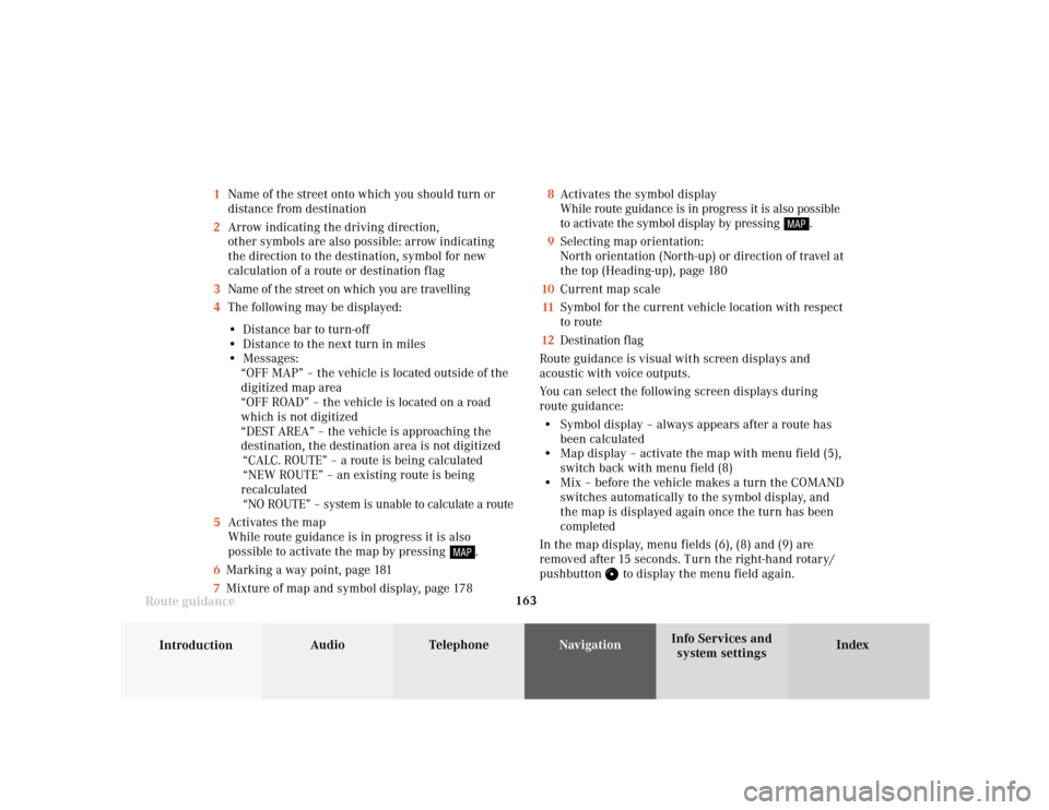
system settings Route guidance1Name of the street onto which you should turn or
distance from destination
2Arrow indicating the driving direction,
other symbols are also possible: arrow indicating
the direction to the destination, symbol for new
calculation of a route or destination flag
3Name of the street on which you are travelling
4The following may be displayed:
• Distance bar to turn-off
• Distance to the next turn in miles
• Messages:
“OFF MAP” – the vehicle is located outside of the
digitized map area
“OFF ROAD” – the vehicle is located on a road
which is not digitized
“DEST AREA” – the vehicle is approaching the
destination, the destination area is not digitized
“CALC. ROUTE” – a route is being calculated
“NEW ROUTE” – an existing route is being
recalculated
“NO ROUTE” – system is unable to calculate a route
5Activates the map
While route guidance is in progress it is also
possible to activate the map by pressing
.
6Marking a way point, page 181
7Mixture of map and symbol display, page 1788Activates the symbol display
While route guidance is in progress it is also possible
to activate the symbol display by pressing
.
9Selecting map orientation:
North orientation (North-up) or direction of travel at
the top (Heading-up), page 180
10Current map scale
11Symbol for the current vehicle location with respect
to route
12Destination flag
Route guidance is visual with screen displays and
acoustic with voice outputs.
You can select the following screen displays during
route guidance:
• Symbol display – always appears after a route has
been calculated
• Map display – activate the map with menu field (5),
switch back with menu field (8)
• Mix – before the vehicle makes a turn the COMAND
switches automatically to the symbol display, and
the map is displayed again once the turn has been
completed
In the map display, menu fields (6), (8) and (9) are
removed after 15 seconds. Turn the right-hand rotary/
pushbutton
to display the menu field again.
Page 166 of 231
164
Introduction Audio Telephone
Navigation
Index Info Services and
system settings
Route guidance
Requesting destination and route information
After the route has been calculated, it is possible to
request destination and route information.
Press
.1Estimated time of arrival
2Distance from destination
Use the right-hand rotary/pushbutton
to highlight
the menu field and press it to confirm:
3Displays the route list, page 165
4Displays the location map, page 167
5Displays current destination, page 168
6Requests the route mode, page 169
7Activates the route map, page 170
8Displays stop-over, page 171
Route guidance is switched off:
The last destination driven to will appear in line (1).
P82.85-6106-26
12
3
6
7
45
8
Page 167 of 231
165
Introduction
Audio Telephone
Navigation
Index Info Services and
system settings Route guidanceDisplaying the route list
Turn the right-hand rotary/pushbutton
to highlight
menu field (3) and press to confirm. The following
message will appear: “Compiling Route List...”.
The route list contains a list of streets which will be
travelled or which still lie ahead.Press
to display long entries in full in a window.
Press to remove the window from the screen.
Turn the right-hand rotary/pushbutton
to move to
the next/previous page, move the cursor past the
upper/lower scrolling symbol.
Press
twice to return to the symbol display or the
map.
Notes:
The route list is updated during the trip, the display
will indicate the streets which remain to be travelled.
If a longer route is calculated to avoid sections of the
freeway (page 159), these freeways may still appear on
the route list. As the vehicle approaches the freeway, it
will be deleted from the list.
P82.85-6137-26
Page 168 of 231
166
Introduction Audio Telephone
Navigation
Index Info Services and
system settings
Route guidance
Activating the route map
Turn the right-hand rotary/pushbutton
to menu
field “Route map” (page 164) and press to confirm.
The route map shows the general view for the whole
route.9Current vehicle position
10Route displayed as a blue line
11Destination
The map scale selected depends on the route. The route
map faces north.
Press
twice to return to the symbol display or the
map.
P82.85-6108-26
9
10
11
Page 169 of 231
167
Introduction
Audio Telephone
Navigation
Index Info Services and
system settings Route guidance
P82.85-2529-26
16
15
14
13
12
Activating the location map
Turn the right-hand rotary/pushbutton
to menu
field “Location map” (page 164) and press to confirm.
The position map faces north.12Number of satellites received
13Geographical latitude and longitude for your
current position
14Scale of the last activation of the position map,
Altering the map scale, page 179
15Current vehicle position in the center of the screen
16Name of the street you are currently travelling on
Press
twice to return to the symbol display or the
map.
To activate the position map with route guidance
switched off:
Press .
Page 170 of 231
168
Introduction Audio Telephone
Navigation
Index Info Services and
system settings
Route guidance
Displaying the current destination
Use the right-hand rotary/pushbutton
to highlight
the menu field “Current destination” in the menu (page
164) and press it to confirm.Press
to return to symbol display or the map.
P82.85-6109-26