2020 AUDI TT COUPE sat nav
[x] Cancel search: sat navPage 5 of 280

8S1012721BB
Table of contents
MMI On/Off knob with joystick function.. 111
MMI operation...........00--0ee eee 112
MMItOUEH: « + seers 2 » wesem 2 2 mame & ¢ gores 113
Control knob with joystick function..... 116
Letter/number speller................ 117
FReetext Search « xc « x saves © ¢ mom 2 3 ee 119
Menus and symbols............000005 120
Voice recognition system........ is
Generalinformation................. 122
OPerariing x « cencamn a 6 ceeseon © 6 eum x mere aw 123
Command overview information........ 124
GomMands « cages « x sess x x caus a 2 ce 124
Telephone...............-.-2-0055 129
INtrOAUEtION « © sens x = sees + oe ws 2 e eee 129
S@tUP cocess & ascewms vo sucnene wo meus ow nea 129
Using the Audi phone box............. 131
Using the telephone.................. 133
FaVOriteS) wes ss ese oo wie ae emer Ys ener 135
MessageS .....-. 0-00 cece eee eee 135
Listening to voicemail................ 138
Emergency call functions.............. 138
Directory.......... 0.0... eee eee 138
Settings... 140
Safety belt microphone............... 141
TrouDLESHOOLIAG veiw v wcaueee oo useseae ee mininse 141
AUCLCONNECE «isa & cows at ees ees 142
General information................. 142
Audi connect Infotainment............ 142
Using a Wi-Fi hotspot................ 144
Audi connect Infotainment services..... 144
Settings...............0. 00.00 eae 146
Troubleshooting wma « xan 9 = sere 3 2 reR 147
Navigation....................000. 149
Opening navigation.................. 149
Entering adestination................ 150
Home address.............0000 0000 155
FaVOriteS, sax ss cave 3 @ mates & § Bains 3 £ Bares 155
Directory comtactsins: os scores « 3 sme & 6 eases 155
Alternative routes)... cues cecnee renee 156
Additional settings.................. 156
MaPies = « soos = © seems « 2 saews ¥ e saree ¢ & Ras 158
Satellite map............... 02 eeeaee 161
Accessing traffic information.......... 162
Troubleshooting sass ¢ eee « + seme & + eee 164
FREUHLON: ci cvies oo uscwwe oo cawoos wo sean o comane 165
Opening the radio.............-.004- 165
RadiG TUNCEIONS waex 2 woen x 2 wee ae een 166
Radioiment « « sssoes 2 x snwons v a cnowune «0 oman 167
Presets ......... 02. 167
Additional settings................0. 168
Troubleshooting wv. ieee oewa es ood 169
Media.......................000 00 170
Introduction’s s « sus « = mae sv eae & v awe 170
INGEOS 6. cecein «5 crannies evaanna i soetiia @ «seen 170
Media drives.............0.00 000 eee 171
Bluetooth audio player............... 173
Wi-Fi audio player................04. 174
Online media and Internet radio........ 175
Multimedia connections.............. 176
Playing Medial. « s swioss a 2 saxsee a 6 amass «5 ne 178
Additional settings 181
Supported media and file formats ...... 183
Troubleshooting sieves x 2 wer 2 o aoeeve ov ence 185
Audi smartphone interface...... 187
SOtup « svi ¥ « owas 9 mes se rem » women « 187
Operating................0..0.0000. 188
Troubleshooting «ess 2s ec8 se vee ss oes 188
System settings.................. 189
Setting the date andtime............. 189
MMI-SettingS’: + eam ss wean os wom 4 e eon 189
Connection manager...............-- 190
System update.............0.- 0 eee ee 192
Sound S@ttingS wees < = seme s = eewis : eee 193
Volume:settings oie
Restarting the MMI (reset)............ 194
Software license information.......... 194
Maintenance and Care........... 195
Checking and Filling............. 195
FUC bis « sence 2 maim wo ane o 8 owOR & HHT 195
Refueling .......... 2.000 e eee ee eee 196
Emissions control system............. 199
Engine compartment................. 200
Engine oil... . kee eee eee 203
Cooling system. ..........0.--0 ee eee 206
Brak@ fluid as s aan « s aces es wees 3 2 eee 208
Electrical system. ............2.-000. 208
Battery... 00... cee cece 209
Page 129 of 280

8S1012721BB
Voice recognition system
Requirement: you must be in the Navigation or Depending on the vehicle equipment and the se-
Map menu. lected menu item, you can say the following com-
mands for additional settings in navigation:
Function Say:
General map options Map / Day map / Night map / Automatically change map color
Map type 2D heading-up map / 2D north-up map / 3D map / Destina-
tion map / Overview map / Standard map / Traffic map / Satel-
lite map*?)
Showing the route list Route list
Showing the remaining distance/ Destination information
time when route guidance is active
Speed limit prompt How fast can I drive here
Setting voice guidance for active Voice guidance on / Voice guidance off / Voice guidance short-
route guidance ened / Voice guidance complete / Voice guidance traffic
Blocking a certain section on the Block route for (XY) meters/kilometers/yards/miles / Block
route next route / Avoid next section of route
a) AUDI AG provides access to services from third party providers. Permanent availability cannot be guaranteed, because that
depends on the third party provider.
® Note are located and which menu language you
have selected.
Read the information about Audi connect, and
be sure to note the connectivity costs section
=@ in General information on page 142.
G) Tips
Destinations may have to be spelled when en-
tered, depending on the country where you
Applies to: vehicles with voice recognition system
Requirement: the Radio must already be open. Depending on the vehicle equipment and the se-
lected frequency band, you can say the following
commands:
Function Say:
Selecting the frequency band FM / SiriusXM* / AM
Selecting a station from the station | Channel (XY) / Frequency (XY) / Last stations
list
Selecting a station from the presets | Radio presets > Line (XY)
Setting the frequency Frequency (XY)
Setting the frequency Frequency (XY) / Frequency (XY) HD 1
Correcting data input No I meant (XY)
Closing the full-screen command Close
list
127
Page 151 of 280

8S1012721BB
Navigation
Navigation
Opening navigation
Applies to: vehicles with navigation system
a
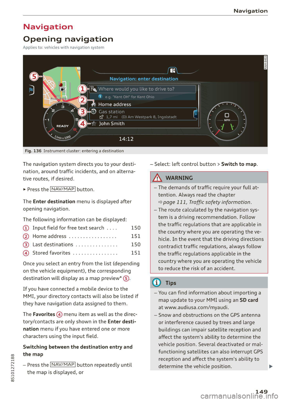
Fig. 136 Instrument cluster: entering a destination
The navigation system directs you to your desti-
nation, around traffic incidents, and on alterna-
tive routes, if desired.
> Press the [NAV/MAP| button.
The Enter destination menu is displayed after
opening navigation.
The following information can be displayed:
@ Input field for free text search .... 150
@ Home address ................. 151
@® Last destinations ............... 150
@ Stored favorites ................ 151
Once you select an entry from the list (depending
on the vehicle equipment), the corresponding
destination will display as a map preview* ().
If you have connected a mobile device to the
MMI, your directory contacts will also be listed if
they have navigation data assigned to them.
The Favorites (4) menu item as well as the direc-
tory/contacts are only shown in the Enter desti-
nation menu if you have entered one or more
characters using the input field.
Switching between the destination entry and
the map
— Press the [NAV/MAP] button repeatedly until
the map is displayed, or
— Select: left control button > Switch to map.
Z\ WARNING
— The demands of traffic require your full at-
tention. Always read the chapter
=> page 111, Traffic safety information.
—The route calculated by the navigation sys-
tem is a driving recommendation. Follow
the traffic regulations that are applicable in
the country where you are operating the ve-
hicle. In the event that the driving directions
contradict traffic regulations, always follow
the traffic regulations applicable in the
country where you are operating the vehicle
to reduce the risk of an accident.
(i) Tips
— You can find information about importing a
map update to your MMI using an SD card
at www.audiusa.com/myaudi.
— Snow and obstructions on the GPS antenna
or interference caused by trees and large
buildings can impair satellite reception and
affect the system's ability to determine the
vehicle position. Several deactivated or mal-
functioning satellites can also interrupt GPS
reception and affect the system's ability to
determine the vehicle position.
149
Page 162 of 280

Navigation
Parking along the route: parking options along
the route will be displayed.
Save current position: you can save your current
vehicle position as a favorite > page 155 or save
it as a contact in the directory > page 155.
Audi connect at this location*: allows you to
search for travel information at the entered loca-
tion (events, weather at the destination, etc.).
Country information: you can display the appli-
cable urban and rural speed limits for any coun-
try/state. This information will be automatically
shown to you in the route information (5)
=> page 158, fig. 142 when the speed limit is ex-
ceeded, if this function is activated > page 160.
Avoid route*: when route guidance is active, the
calculated route will avoid the area you have
specified (maximum: 12 mi (20 km)), if possible.
The navigation system calculates an alternative
route. The route to be avoided that you have en-
tered applies only to the current route and must
be set again, if needed. The areas you have se-
lected to avoid will appear with red and white
shading on the map.
Map settings
Applies
to: vehicles with navigation system
> Press the [NAV/MAP] button repeatedly until
the map is displayed > page 158, fig. 142.
> Select: right control button > Map settings.
Depending on the selected function, the follow-
ing settings can be selected:
Map colors
Day/Night: the map is displayed with a light/
dark background.
Automatic: when the lights switch on, the map
colors switch from day to night.
Map display
Standard > page 158, fig. 141.
Satellite map*)) > page 161, fig. 143.
2) AUDI AG provides access to services from third party pro-
viders. Permanent availability cannot be guaranteed, be-
cause that depends on the third party provider.
160
Traffic > page 162.
Map orientation
Destination map: the map indicates the destina-
tion and is oriented to the north.
2D heading up map/2D north up map: the cur-
rent vehicle position is displayed. The map is ori-
ented in the direction of travel or to the north.
3D heading-up map: when this function is
switched on, the current vehicle position is
shown on a three-dimensional map and oriented
in the direction of travel. At a scale of 62 mi
(100 km) and larger, the map orientation is to
the north.
Overview map: the entire route from the vehicle
position to the destination or the next stopover is
displayed on the map. The map scale depends on
the length of the route and adapts automatically.
The map is oriented to the north.
Route information
The display of route information such as the cur-
rent road being driven on, upcoming maneuvers,
traffic information or points of interest along the
route can be switched on/off.
Automatic zoom
On: the map scale is adapted automatically de-
pending on the type of road being traveled (ex-
pressway, highway, other roads) so that you al-
ways have an optimal overview of the road ahead.
The scale will also be automatically adapted
when there are upcoming maneuvers to provide a
better detailed view.
Off: the map scale you have chosen is main-
tained.
Map content
Map content, such as traffic information, favor-
ites or restaurants, can be displayed or hidden
(™).
Page 163 of 280

8S1012721BB
Navigation
Satellite map
Applies to: vehicles with navigation system and Audi connect
Infotainment
bo} f=
S Figueroa St
W Washington Blvd 7
Los Angeles ee
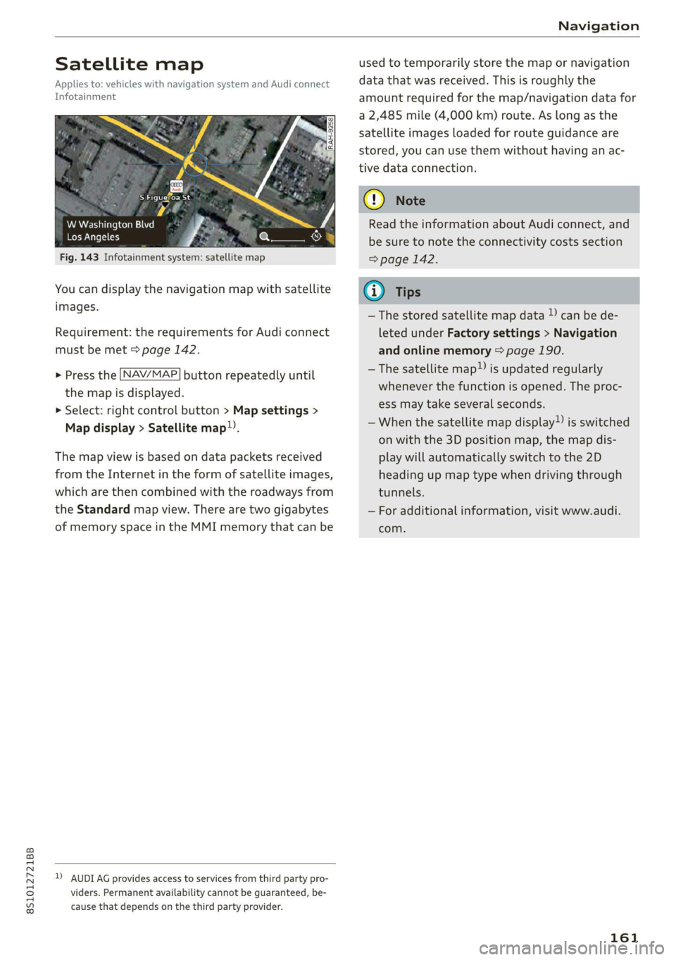
Fig. 143 Infotainment system: satellite map
You can display the navigation map with satellite
images.
Requirement: the requirements for Audi connect
must be met > page 142.
> Press the [NAV/MAP] button repeatedly until
the map is displayed.
> Select: right control button > Map settings >
Map display > Satellite map.
The map view is based on data packets received
from the Internet in the form of satellite images,
which are then combined with the roadways from
the Standard map view. There are two gigabytes
of memory space in the MMI memory that can be
D) AUDI AG provides access to services from third party pro-
viders. Permanent availability cannot be guaranteed, be-
cause that depends on the third party provider.
used to temporarily store the map or navigation
data that was received. This is roughly the
amount required for the map/navigation data for
a 2,485 mile (4,000 km) route. As long as the
satellite images loaded for route guidance are
stored, you can use them without having an ac-
tive data connection.
Q) Note
Read the information about Audi connect, and
be sure to note the connectivity costs section
=> page 142.
@ Tips
—The stored satellite map data )) can be de-
leted under Factory settings > Navigation
and online memory > page 190.
—The satellite map”) is updated regularly
whenever the function is opened. The proc-
ess may take several seconds.
—When the satellite map display”) is switched
on with the 3D position map, the map dis-
play will automatically switch to the 2D
heading up map type when driving through
tunnels.
— For additional information, visit www.audi.
com.
161
Page 165 of 280

8S1012721BB
Navigation
You can also display the online traffic informa-
tion in the satellite map*») > page 161 or the
standard map > page 158, fig. 141
@ Note
Read the information about Audi connect, and
be sure to note the connectivity costs section
=> page 142.
G) Tips
— Having the Online traffic data function
switched on provides the most accurate re-
ports of traffic situations as well as traffic
forecasting. Your vehicle transmits and
processes its anonymous, encrypted posi-
tion information at regular intervals to the
traffic data provider. If you do not want to
use this, you can switch off the online traf-
fic information function at any time.
— The online traffic information network is
currently not available in all countries, and
the coverage is not nationwide. For addi-
tional information, visit www.audi.com.
Better route
Applies to: vehicles with Audi connect Infotainment naviga-
tion system
By receiving traffic information online, your MMI
calculates a better route if available and the pos-
sible time saved compared to the current route.
You can decide which route you would like to use.
Selecting a better route
Requirement: route guidance must be active and
online traffic information must be available
= page 162
2) AUDI AG provides access to services from third party pro-
viders. Permanent availability cannot be guaranteed, be-
cause that depends on the third party provider.
> Press the [NAV/MAP] button repeatedly until
the map is displayed.
If your MMI has calculated a better route than
the current route guidance, the message A better
route is available. appears for several seconds
along with the time that may be saved. A better
route is indicated in the map view by the symbol
® © page 158, fig. 141.
Apply better route
> Press the right control button in the map view,
or:
> Select: left control button > Traffic messages.
The better route with the calculated arrival
time is displayed.
> Select and confirm the better route, or:
> Select and confirm Details to display details
about the better route.
> You can zoom in or out on the map using the
MMI touch control pad.
Requirement: there must be more than one opti-
mized route calculated.
> Press the control knob to switch to the next
route in the detailed view.
> Closing the detailed view: press the [BACK
button.
After you have selected a better route, the route
will be recalculated.
163