2019 AUDI TT ROADSTER navigation system
[x] Cancel search: navigation systemPage 138 of 304
Navigation
that were found is not resorted when this
happens.
— There may be entries in the list that cannot
be displayed completely due to their length.
If you select these list entries using the con-
trol knob, detailed information about the
selected list entry will be shown automati-
cally after several seconds.
Online point of interest sear
search)
Applies to: vehicles with navigation system and Audi connect
(online
You can search for points of interest on the Inter-
net.
Requirement: the requirements for Audi connect
services must be met > page 125.
> Press the LNAV/MAP] button repeatedly until
the Enter destination menu is displayed
=> page 132, fig. 118.
> Select: left control button > Online search. The
search area last set is shown in the input field.
— Changing the search area: select and confirm
Search area > a search area from the list.
— Searching for online destinations in the se-
lected search area: enter a new city if necessa-
ry. Enter a search term such as restaurant. Se-
lect and confirm an online destination. Select
and confirm Start route guidance.
— Searching for an online destination in a specif-
ic category: select: Select category > desired
category, such as Hotels.
Find which search areas are available under
=> page 135, Point of interest search.
You can search for online destinations using the
voice recognition system = table on page 107.
G) Tips
Always read the chapter > page 125.
136
OXee Te Melee el mA e |
account
Applies to: vehicles with navigation system and Audi connect
Import destinations from your myAudi account
into the MMI.
Requirement: you must have created a myAudi
account at www.audiusa.com/myaudi. You must
have a vehicle stored in your myAudi account and
you must have a destination stored.
> Press the [NAV/MAP] button repeatedly until
the Enter destination menu is displayed
=> page 132, fig. 118.
> Select: left control button > myAudi contacts.
> If necessary, enter your myAudi user data or
your myAudi PIN. The contacts stored in myAu-
di are displayed.
— Select and confirm a contact > desired destina-
tion.
— Select and confirm Start route guidance.
(i) Tips
— You only need to enter the myAudi user data
one time.
— You can receive your myAudi PIN if you have
set up a myAudi account.
— For additional information, see www.
audiusa.com/myaudi.
Entering a destination using geo
coordinates
Applies to: vehicles with navigation system
> Press the [NAV/MAP] button repeatedly until
the Enter destination menu is displayed
=> page 132, fig. 118.
> Select: left control button > Geographical coor-
dinates.
— Select and confirm either Latitude or Longi-
tude.
— Turn the control knob to change the latitude/
longitude.
— Press the control knob to confirm your input.
— Select and confirm Start route guidance.
Page 139 of 304
8S8012721BA
Navigation
Adding a stopover
Applies to: vehicles with navigation system
You can enter an additional destination when
route guidance is active.
& Bear Valley Rd
Ss i
Delete destination
@x Cae eal acre
in am) it
Delete stopover
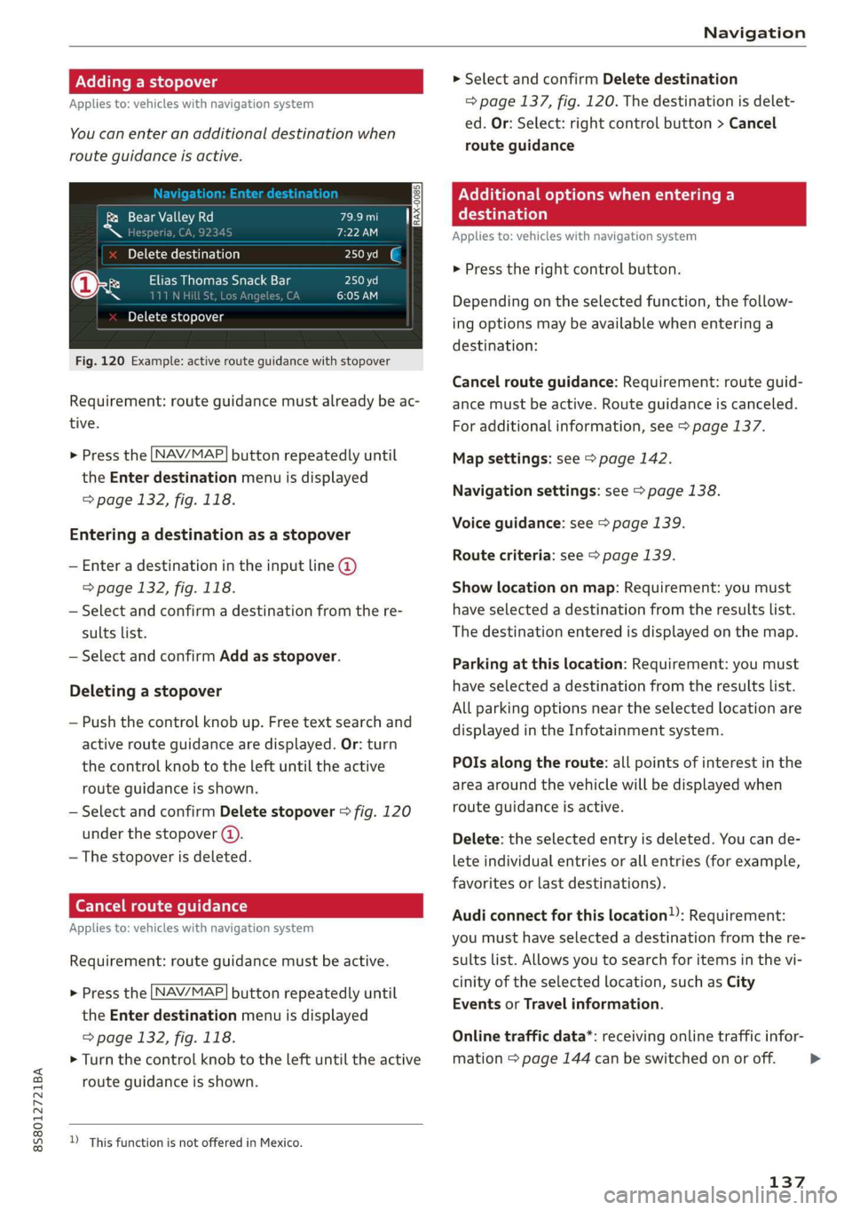
Fig. 120 Example: active route guidance with stopover
Requirement: route guidance must already be ac-
tive.
> Press the [NAV/MAP| button repeatedly until
the Enter destination menu is displayed
=> page 132, fig. 118.
Entering a destination as a stopover
— Enter a destination in the input line @
=> page 132, fig. 118.
— Select and confirm a destination from the re-
sults list.
— Select and confirm Add as stopover.
Deleting a stopover
— Push the control knob up. Free text search and
active route guidance are displayed. Or: turn
the control knob to the left until the active
route guidance is shown.
— Select and confirm Delete stopover > fig. 120
under the stopover (4).
— The stopover is deleted.
Ce Te mlm Tia
Applies to: vehicles with navigation system
Requirement: route guidance must be active.
> Press the [NAV/MAP| button repeatedly until
the Enter destination menu is displayed
=> page 132, fig. 118.
> Turn the control knob to the left until the active
route guidance is shown.
D_ This function is not offered in Mexico.
> Select and confirm Delete destination
=> page 137, fig. 120. The destination is delet-
ed. Or: Select: right control button > Cancel
route guidance
Nellie me) eee Cela lal Be)
eaten)
Applies to: vehicles with navigation system
> Press the right control button.
Depending on the selected function, the follow-
ing options may be available when entering a
destination:
Cancel route guidance: Requirement: route guid-
ance must be active. Route guidance is canceled.
For additional information, see > page 137.
Map settings: see > page 142.
Navigation settings: see > page 138.
Voice guidance: see > page 139.
Route criteria: see > page 139.
Show location on map: Requirement: you must
have selected a destination from the results list.
The destination entered is displayed on the map.
Parking at this location: Requirement: you must
have selected a destination from the results list.
All parking options near the selected location are
displayed in the Infotainment system.
POIs along the route: all points of interest in the
area around the vehicle will be displayed when
route guidance is active.
Delete: the selected entry is deleted. You can de-
lete individual entries or all entries (for example,
favorites or last destinations).
Audi connect for this location): Requirement:
you must have selected a destination from the re-
sults list. Allows you to search for items in the vi-
cinity of the selected location, such as City
Events or Travel information.
Online traffic data*: receiving online traffic infor-
mation > page 144 can be switched on or off.
137
>
Page 140 of 304
Navigation
Country/state selection: see > page 133, Nar-
rowing the search area.
Store as favorite: see > page 138.
Home address
Applies to: vehicles with navigation system
NAV/MAP. > Press the button repeatedly until
the Enter destination menu is displayed
=> page 132, fig. 118.
Storing a home address
— Select and confirm Home address (2)
=> page 132, fig. 118. After opening the home
address for the first time, you will be asked to
create a home address.
— Select and confirm Create now.
— Enter a destination or select a destination from
the list.
Editing the home address
— Select Home address (2) > page 132, fig. 118.
— Select: right control button > Edit home ad-
dress.
— Select and confirm a new destination as the
home address.
The selected destination is stored as the new
home address.
Favorites
Applies to: vehicles with navigation system
NAV/MAP > Press the button repeatedly until
the Enter destination menu is displayed
=> page 132, fig. 118.
— Storing a destination as a favorite: search for
the desired destination using the input field.
Or: select a destination from the list. Select:
right control button > Store as favorite.
— Renaming a favorite: select the left control
button > Favorites > a favorite from the list >
right control button > Rename favorite.
— Move favorite: select a favorite from the list >
right control button > Move favorite. Select
and confirm the location of the selected favor-
ite.
138
— Deleting a favorite: select a favorite from the
list > right control button > Delete favorite >
Delete this favorite or Delete all favorites.
Directory contacts
Applies to: vehicles with navigation system
Two addresses (private/business) can be as-
signed as destinations for each contact in the di-
rectory.
NAV/MAP > Press the button repeatedly until
the Enter destination menu is displayed
=> page 132, fig. 118.
Storing a destination as a contact in the
directory
Requirement: a cell phone must be connected to
the MMI.
— Select: a destination > right control button >
Add destination to contact.
— Enter the first letters of the desired contact in
the free text search input field > page 132,
fig. 118 and then select a contact from the list.
— Select and confirm Add business destination or
Add private destination.
Additional settings
Navigation settings
Applies
to: vehicles with navigation system
> Press the [NAV/MAP button repeatedly until
the Enter destination menu is displayed
=> page 132, fig. 118.
> Select: right control button > Navigation set-
tings.
Depending on the selected function, the follow-
ing settings can be selected:
Show alternative routes
Up to three route suggestions and their proper-
ties are displayed on the overview map when the
function is switched on 4. See > page 139, Al-
ternative routes.
Low fuel warning
A message is displayed if the fuel gauge goes be-
low the reserve marking when this function is >
Page 141 of 304
8S58012721BA
Navigation
switched on M. After confirming this message, a
list of gas stations in the area is displayed. When
a gas station is selected, route guidance from the
current vehicle position is calculated.
Notification when nearby*
The notification when nearby is switched off at
the factory.
The MMI notifies you when you are approaching
selected points of interest when this function is
switched on. You can also have a Notification
tone.
Presentation mode
The Presentation mode helps you to effectively
plan a trip and follow the planned route without
moving the vehicle. You can use Select starting
point when you would like to calculate a route
starting
from a location other than the vehicle
position, for example. Start Presentation mode
to simulate route guidance.
ol eter]
Applies to: vehicles with navigation system
10) [8
|e
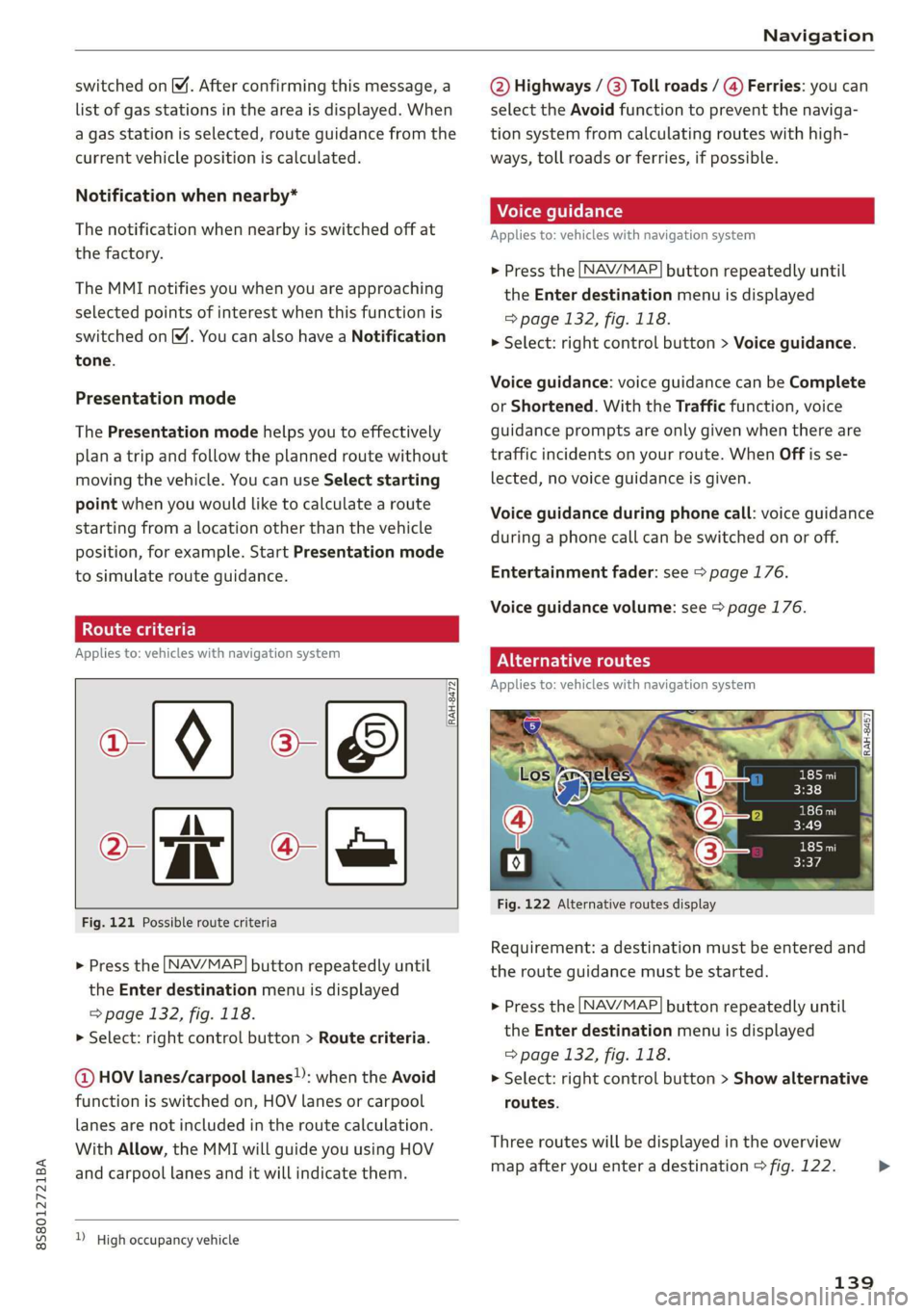
Fig. 121 Possible route criteria
RAH-8472|
Q-
> Press the LNAV/MAP] button repeatedly until
the Enter destination menu is displayed
=> page 132, fig. 118.
> Select: right control button > Route criteria.
@ HOV lanes/carpool lanes): when the Avoid
function is switched on, HOV lanes or carpool
lanes are not included in the route calculation.
With Allow, the MMI will guide you using HOV
and carpool lanes and it will indicate them.
) High occupancy vehicle
@ Highways / (3) Toll roads / @) Ferries: you can
select the Avoid function to prevent the naviga-
tion system from calculating routes with high-
ways, toll roads or ferries, if possible.
Applies to: vehicles with navigation system
> Press the [NAV/MAP] button repeatedly until
the Enter destination menu is displayed
=> page 132, fig. 118.
> Select: right control button > Voice guidance.
Voice guidance: voice guidance can be Complete
or Shortened. With the Traffic function, voice
guidance prompts are only given when there are
traffic incidents on your route. When Off is se-
lected, no voice guidance is given.
Voice guidance during phone call: voice guidance
during a phone call can be switched on or off.
Entertainment fader: see > page 176.
Voice guidance volume: see > page 176.
PNG Tree)
Applies to: vehicles with navigation system
Fig. 122 Alternative routes display
Requirement: a destination must be entered and
the route guidance must be started.
> Press the [NAV/MAP] button repeatedly until
the Enter destination menu is displayed
=> page 132, fig. 118.
> Select: right control button > Show alternative
routes.
Three routes will be displayed in the overview
map after you enter a destination > fig. 122. >
139
Page 142 of 304

Navigation
If available, the following information will ap- The route that was calculated according to the
pear on the route suggestions: route criteria you selected is shown on the map.
— Route type (fast (, fast alternative (2), eco-
nomic route @))
— Distance to the destination and the calculated
arrival time
The special properties of the route (such as ferry
connections) may be displayed (4) > fig. 122. Ad-
ditional information about individual route crite-
ria can be found in > page 139.
— Traffic congestion along the route including
time
delays
Map
Operating the map
Applies to: vehicles with navigation system
Fig. 124 Diagram: map with crosshairs turned off
> Press the
NAV/MAP button repeatedly until the map using the MMI touch > page 96. Or:
the map is displayed > fig. 124. turn the left thumbwheel on the multifunction
steering wheel* > page 12.
Zooming in/out on the map
Turning the crosshairs on/off
— Turn the control knob to the left or to the right.
As an alternative, you can also zoom in/out on
140
Page 143 of 304
8S58012721BA
Navigation
— Switching the crosshairs on: press the control
knob in the map view.
— Switching the crosshairs off: press the [BACK
button.
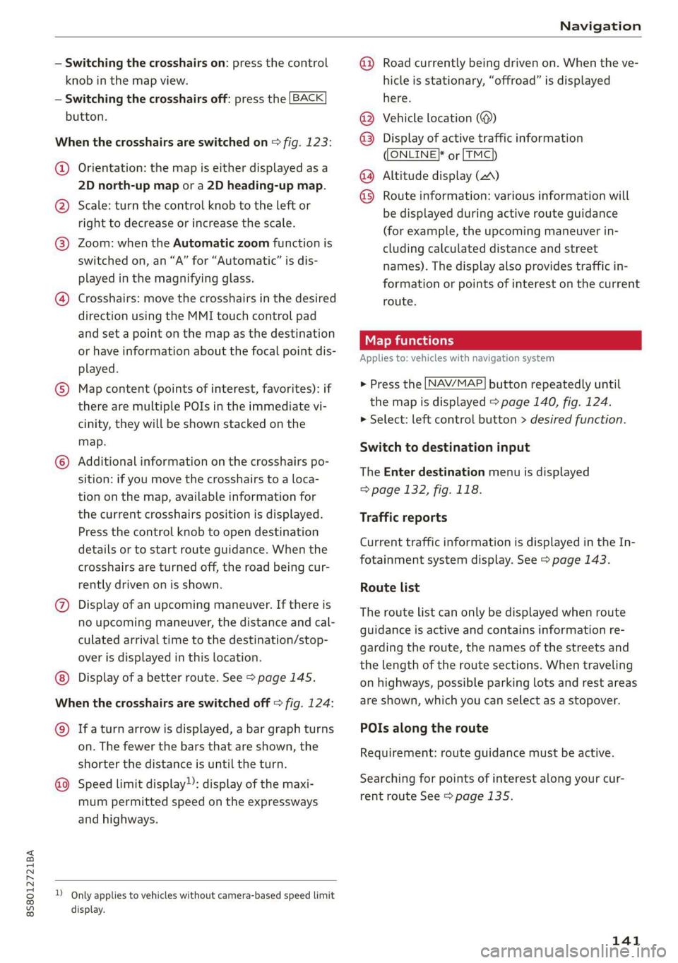
When the crosshairs are switched on > fig. 123:
@ Orientation: the map is either displayed as a
2D north-up map or a 2D heading-up map.
@) Scale: turn the control knob to the left or
right to decrease or increase the scale.
@ Zoom: when the Automatic zoom function is
switched on, an “A” for “Automatic” is dis-
played in the magnifying glass.
@ Crosshairs: move the crosshairs in the desired
direction using the MMI touch control pad
and set a point on the map as the destination
or have information about the focal point dis-
played.
© Map content (points of interest, favorites): if
there are multiple POIs in the immediate vi-
cinity, they will be shown stacked on the
map.
© Additional information on the crosshairs po-
sition: if you move the crosshairs to a loca-
tion on the map, available information for
the current crosshairs position is displayed.
Press the control knob to open destination
details or to start route guidance. When the
crosshairs are turned off, the road being cur-
rently driven on is shown.
@ Display of an upcoming maneuver. If there is
no upcoming maneuver, the distance and cal-
culated arrival time to the destination/stop-
over is displayed in this location.
Display of a better route. See > page 145.
When the crosshairs are switched off > fig. 124:
@) Ifa turn arrow is displayed, a bar graph turns
on. The fewer the bars that are shown, the
shorter the distance is until the turn.
Speed limit display): display of the maxi-
mum permitted speed on the expressways
and highways.
D_ Only applies to vehicles without camera-based speed limit
display.
@ Road currently being driven on. When the ve-
hicle is stationary, “offroad” is displayed
here.
Vehicle location (@)
Display of active traffic information
ONLINE} or [TMC
Altitude display (2)
Route information: various information will
be displayed during active route guidance
(for example, the upcoming maneuver in-
cluding calculated distance and street
names). The display also provides traffic in-
formation or points of interest on the current
route.
Applies to: vehicles with navigation system
®® O®
> Press the [NAV/MAP] button repeatedly until
the map is displayed > page 140, fig. 124.
> Select: left control button > desired function.
Switch to destination input
The Enter destination menu is displayed
=> page 132, fig. 118.
Traffic reports
Current traffic information is displayed in the In-
fotainment system display. See > page 143.
Route list
The route list can only be displayed when route
guidance is active and contains information re-
garding the route, the names of the streets and
the length of the route sections. When traveling
on highways, possible parking lots and rest areas
are shown, which you can select as a stopover.
POIs along the route
Requirement: route guidance must be active.
Searching for points of interest along your cur-
rent route See > page 135.
141
Page 144 of 304
![AUDI TT ROADSTER 2019 Owners Manual Navigation
Additional options on the map
Applies to: vehicles with navigation system
> Press the LNAV/MAP] button repeatedly until
the map is displayed > page 140, fig. 124.
> Press AUDI TT ROADSTER 2019 Owners Manual Navigation
Additional options on the map
Applies to: vehicles with navigation system
> Press the LNAV/MAP] button repeatedly until
the map is displayed > page 140, fig. 124.
> Press](/manual-img/6/57667/w960_57667-143.png)
Navigation
Additional options on the map
Applies to: vehicles with navigation system
> Press the LNAV/MAP] button repeatedly until
the map is displayed > page 140, fig. 124.
> Press the right control button.
Depending on the function selected, the follow-
ing options can also be selected under the Map
menu:
Cancel route guidance: see > page 137.
Map settings: see > page 142.
Route criteria: see > page 139.
Voice guidance: see > page 139.
Navigation settings: see > page 138.
Online traffic data*: see > page 143.
Show alternative routes: see > page 139.
Parking along the route: parking options near
the vehicle are displayed.
Save current position: you can save your current
vehicle position as a favorite > page 138 or save
it as a contact in the directory > page 138.
Audi connect at this location*: allows you to
search for City Events or Weather at the entered
location.
Country information: you can display the appli-
cable urban and rural speed limits for any coun-
try/state. This information will be automatically
shown to you in the route information @)
=> page 140, fig. 124 when the speed limit is ex-
ceeded, if this function is activated > page 142.
Avoid route*: when route guidance is active, the
calculated route will avoid the area you have
specified (maximum: 12 mi (20 km)), if possible.
The navigation system calculates an alternative
route. The route to be avoided that you have en-
tered applies only to the current route and must
be set again, if needed. The areas you have se-
lected to avoid will appear with red and white
shading on the map.
2) AUDI AG provides access to services from third party pro-
viders. Permanent availability cannot be guaranteed, be-
cause that depends on the third party provider.
142
Map settings
Applies to: vehicles with navigation system
> Press the [NAV/MAP] button repeatedly until
the map is displayed > page 140, fig. 124.
> Select: right control button > Map settings.
Depending on the selected function, the follow-
ing settings can be selected:
Map colors
Day/Night: the map is displayed with a light/
dark background.
Automatic: when the lights switch on, the map
colors switch from day to night.
Map display
Standard > page 140, fig. 123.
Satellite map*)) > page 143, fig. 125.
Traffic > page 143.
Map orientation
Destination map: the map indicates the destina-
tion and is oriented to the north.
2D heading-up map/2D north-up map: the cur-
rent vehicle position is displayed. The map is ori-
ented in the direction of travel or to the north.
3D heading-up map: when this function is
switched on, the current vehicle position is
shown on a three-dimensional map and oriented
in the direction of travel. At a scale of 62 mi
(100 km) and larger, the map orientation is to
the north.
Overview map: the entire route from the vehicle
position to the destination or the next stopover is
displayed on the map. The map scale depends on
the length of the route and adapts automatically.
The map is oriented to the north.
Route information
The display of route information such as the cur-
rent road being driven on, upcoming maneuvers, >
Page 145 of 304
8S58012721BA
Navigation
traffic information or points of interest along the
route can be switched on/off.
Automatic zoom
On: the map scale is adapted automatically de-
pending on the type of road being traveled (ex-
pressway, highway, other roads) so that you al-
ways have an optimal overview of the road ahead.
The scale will also be automatically adapted
when there are upcoming maneuvers to provide a
better detailed view.
Off: the map scale you have chosen is main-
tained.
Map content
Map content, such as traffic information, favor-
ites or restaurants, can be displayed or hidden
(™).
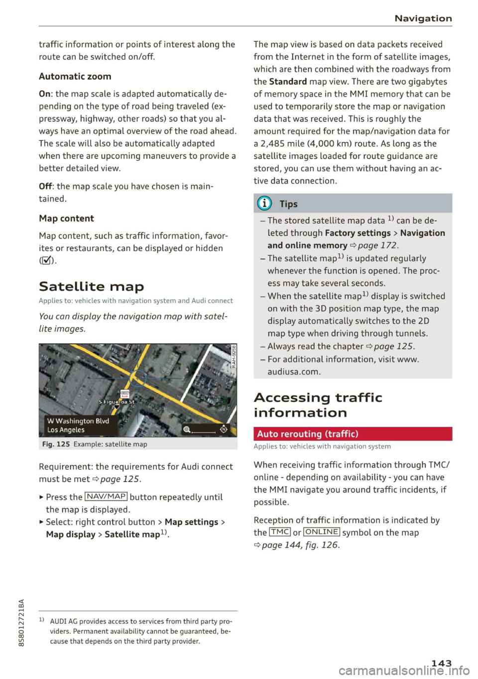
Satellite map
Applies to: vehicles with navigation system and Audi connect
You can display the navigation map with satel-
lite images.
S Figueroa St
W Washington Blvd %
Los Angeles ero
Fig. 125 Example: satellite map
Requirement: the requirements for Audi connect
must be met > page 125.
> Press the [NAV/MAP] button repeatedly until
the map is displayed.
> Select: right control button > Map settings >
Map display > Satellite map!).
D) AUDI AG provides access to services from third party pro-
viders. Permanent availability cannot be guaranteed, be-
cause that depends on the third party provider.
The map view is based on data packets received
from the Internet in the form of satellite images,
which are then combined with the roadways from
the Standard map view. There are two gigabytes
of memory space in the MMI memory that can be
used to temporarily store the map or navigation
data that was received. This is roughly the
amount required for the map/navigation data for
a 2,485 mile (4,000 km) route. As long as the
satellite images loaded for route guidance are
stored, you can use them without having an ac-
tive data connection.
G) Tips
—The stored satellite map data ) can be de-
leted through Factory settings > Navigation
and online memory > page 172.
—The satellite map”) is updated regularly
whenever the function is opened. The proc-
ess may take several seconds.
—When the satellite map”) display is switched
on with the 3D position map type, the map
display automatically switches to the 2D
map type when driving through tunnels.
— Always read the chapter > page 125.
— For additional information, visit www.
audiusa.com.
Accessing traffic
information
Auto rerouting (traffic)
Applies to: vehicles with navigation system
When receiving traffic information through TMC/
online - depending on availability - you can have
the MMI navigate you around traffic incidents, if
possible.
Reception of traffic information is indicated by
the [TMC] or [ONLINE] symbol on the map
=> page 144, fig. 126.
143