2018 Acura RLX lock
[x] Cancel search: lockPage 60 of 159

uuMap uColor
58
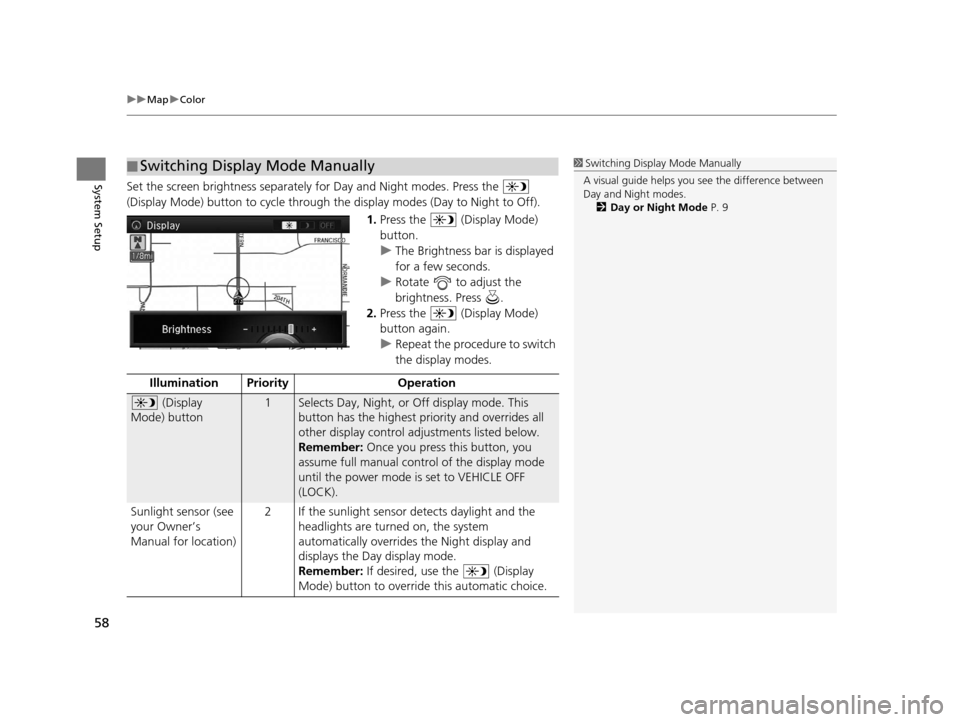
System SetupSet the screen brightness separately for Day and Night modes. Press the
(Display Mode) button to cycle through the display modes (Day to Night to Off).
1.Press the (Display Mode)
button.
u The Brightness bar is displayed
for a few seconds.
u Rotate to adjust the
brightness. Press .
2. Press the (Display Mode)
button again.
u Repeat the procedure to switch
the display modes.
■Switching Display Mode Manually1
Switching Display Mode Manually
A visual guide helps you se e the difference between
Day and Night modes.
2 Day or Night Mode P. 9
Illumination Priority Operation
(Display
Mode) button1Selects Day, Night, or Off display mode. This
button has the highest priority and overrides all
other display control adjustments listed below.
Remember: Once you press this button, you
assume full manual control of the display mode
until the power mode is set to VEHICLE OFF
(LOCK).
Sunlight sensor (see
your Owner’s
Manual for location) 2 If the sunlight sensor detects daylight and the
headlights are turned on, the system
automatically overrides the Night display and
displays the Day display mode.
Remember: If desired, use the (Display
Mode) button to override this automatic choice.
18 ACURA RLX NAVI FF HYBRID-31TY28500.book 58 ページ 2017年6月26日 月曜日 午後5時13分
Page 72 of 159

70
uuMap uCorrect Vehicle Position
System Setup
Correct Vehicle Position
H SETTINGS buttonuNavi Settings uMap uCorrect Vehicle Position
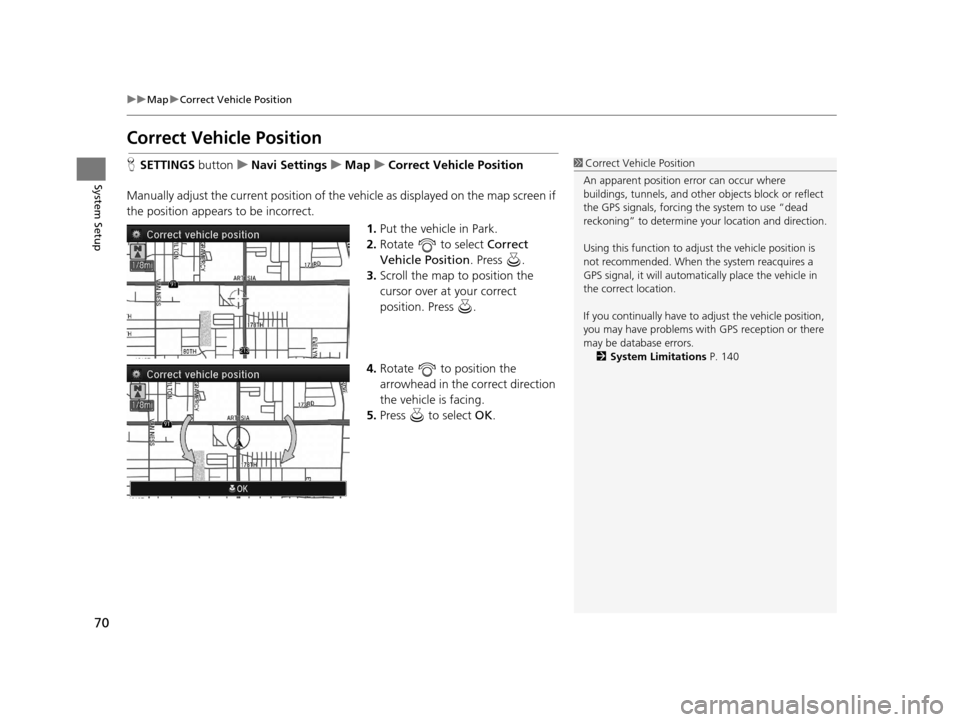
Manually adjust the current position of the vehicle as displayed on the map screen if
the position appears to be incorrect. 1.Put the vehicle in Park.
2. Rotate to select Correct
Vehicle Position . Press .
3. Scroll the map to position the
cursor over at your correct
position. Press .
4. Rotate to position the
arrowhead in the correct direction
the vehicle is facing.
5. Press to select OK.1Correct Vehicle Position
An apparent position error can occur where
buildings, tunnels, and other objects block or reflect
the GPS signals, forcing the system to use “dead
reckoning” to determine your location and direction.
Using this function to adju st the vehicle position is
not recommended. When the system reacquires a
GPS signal, it will automatically place the vehicle in
the correct location.
If you continually have to adjust the vehicle position,
you may have problems with GPS reception or there
may be database errors. 2 System Limitations P. 140
18 ACURA RLX NAVI FF HYBRID-31TY28500.book 70 ページ 2017年6月26日 月曜日 午後5時13分
Page 135 of 159

133
uuTroubleshooting uGuidance, Routing
Troubleshooting
Guidance, Routing
ProblemSolution
The navigation system does not route me the same
way I would go or the same way as other mapping
systems.The navigation system attempts to generate the optimal route. You can change
the route preferences used when calculating a route.
2 Route Preference P. 38
The navigation system wants to route me around
potential traffic problems. How do I stop these pop-
up messages?Press the SETTINGS button. Select Navi Settings > Routing, and set Traffic
Rerouting to Off .
2Traffic Rerouting P. 42
The street I’m on is not shown on the map screen.The mapping database is constantly under going revision. You can access the most
recent information on the internet.
2 Map Coverage P. 143
The vehicle position icon is not following the road
and the “GPS icon” text in the upper left hand
corner of the screen is white or missing.This is normal. The signals received from the GPS satellites are extremely weak and
can easily be interrupted or interfered as your vehicle travel near tall buildings or
in tunnels. Check your vehicle surroundings for anything that may be blocking the
reception. If this happens frequently and th ere is no obstruction that is interfering
with reception, please see a dealer.
2 GPS P. 140
The blue highlighted route and voice guidance
stopped or turned into a blue/pink line before I got
to my destination.Your route has entered an unverified area.
2Unverified Routing P. 40
How do I stop the map from rotating as I drive
along?Press the SETTINGS button. Select Navi Settings > Map > View > North-up .
The “time to destination” display sometimes
increases even though I am getting closer to my
destination.If your speed reduces due to slower tra ffic, the navigation system updates the
“time to destination” based on your actual road speed to give you a better
estimate of arrival time.
The vehicle position icon on the map “lags” a short
distance behind, especially when I arrive at an
intersection.This is normal. The navigati on system is unaware of the width of intersections.
Large differences in vehicle position ca n indicate a temporary loss of the GPS
signal.
2 GPS P. 140
18 ACURA RLX NAVI FF HYBRID-31TY28500.book 133 ページ 2017年6月26日 月曜日 午後5時13分
Page 142 of 159

140
Reference Information
System Limitations
GPS
The signals received from GPS satellites are
extremely weak (less than a millionth of the
strength of a local FM station) and require
an unobstructed view of the sky. The GPS
antenna is located in the roof. The signal
reception can easily be interrupted or
interfered with by trees, tall buildings,
freeway/highway overpasses, tunnels, or
overhead electrical power wires.
GPS is operated by the U.S. Department of
Defense. For security reasons, there are
certain inaccuracies bui lt into GPS for which
the navigation system must constantly
compensate. This can cause occasional
positioning errors of up to several hundred
feet or tens of meters.
Address Calculation
The destination icon shows only the
approximate location of a destination
address. This occurs if the number of
possible addresses is different from the
number of actual addr esses on a block. For
example, the address 1425 on a 1400 block
with 100 possible addresses (because it is
followed by the 1500 block) will be shown a
quarter of the way down the block by the
system. If there are only 25 actual addresses
on the block, the actual location of address
1425 would be at the end of the block.
Database
The digitized map database reflects
conditions as they existed at various points
in time before production. Accordingly,
your database may contain inaccurate or
incomplete data or information due to the
passage of time, road construction,
changing conditions, or other causes.
For example, some places/landmarks may
be missing when you search the database
because the name was misspelled, the place
was improperly categorized, or a place/
landmark is not yet in the database. This is
also true for police stat ions, hospitals, and
other public institutions. Do not rely on the
navigation system if you need law
enforcement or hospital services. Always
check with local information sources.
In addition, the map database contains
verified and unverifie d areas. Unverified
streets may be missing from the map, in the
wrong location, or have an incorrect name
or address range. A message will warn you
if your route includes unverified streets.
Exercise additional caution when driving in
unverified areas.
18 ACURA RLX NAVI FF HYBRID-31TY28500.book 140 ページ 2017年6月26日 月曜日 午後5時13分