2017 NISSAN LEAF navigation
[x] Cancel search: navigationPage 57 of 268
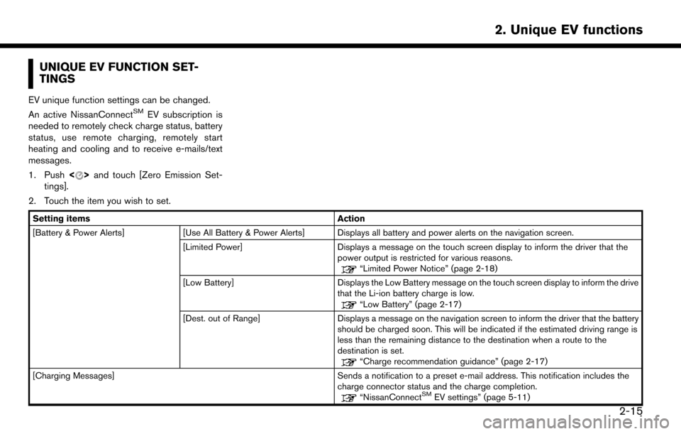
UNIQUE EV FUNCTION SET-
TINGS
EV unique function settings can be changed.
An active NissanConnectSMEV subscription is
needed to remotely check charge status, battery
status, use remote charging, remotely start
heating and cooling and to receive e-mails/text
messages.
1. Push <
>and touch [Zero Emission Set-
tings].
2. Touch the item you wish to set.
Setting items Action
[Battery & Power Alerts] [Use All Battery & Power Alerts] Displays all battery and power alerts on the navigation screen.
[Limited Power] Displays a message on the touch screen display to inform the driver that the
power output is restricted for various reasons.
“Limited Power Notice” (page 2-18)
[Low Battery] Displays the Low Battery message on the touch screen display to inform the drive
that the Li-ion battery charge is low.
“Low Battery” (page 2-17)
[Dest. out of Range] Displays a message on the navigation screen to inform the driver that the battery
should be charged soon. This will be indicated if the estimated driving range is
less than the remaining distance to the destination when a route to the
destination is set.
“Charge recommendation guidance” (page 2-17)
[Charging Messages] Sends a notification to a preset e-mail address. This notification includes the charge connector status and the charge completion.
“NissanConnectSMEV settings” (page 5-11)
2-15
2. Unique EV functions
Page 59 of 268
BATTERY AND POWER INFORMA-
TION
Information notifying the driver of the battery and
power status can be displayed on the touch
screen display.
For detail information about the warning/indica-
tor lights, see the LEAF Owner’s Manual.
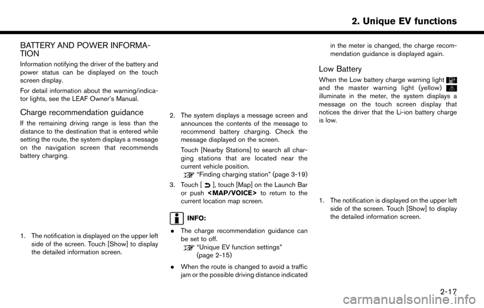
Charge recommendation guidance
If the remaining driving range is less than the
distance to the destination that is entered while
setting the route, the system displays a message
on the navigation screen that recommends
battery charging.
1. The notification is displayed on the upper leftside of the screen. Touch [Show] to display
the detailed information screen.
2. The system displays a message screen and
announces the contents of the message to
recommend battery charging. Check the
message displayed on the screen.
Touch [Nearby Stations] to search all char-
ging stations that are located near the
current vehicle position.
“Finding charging station” (page 3-19)
3. Touch [
], touch [Map] on the Launch Bar
or push
Page 61 of 268
3 Navigation
Safety information ..................................................................... 3-3
Map operation ........................................................................\
.... 3-3Displaying current vehicle location ................................. 3-3
Map types ........................................................................\
...... 3-3
Road color ........................................................................\
..... 3-6
Map symbols ........................................................................\
3-7
Moving map ........................................................................\
.. 3-8
Changing scale of map ...................................................... 3-9
Changing map ................................................................... 3-10
Map view settings ............................................................ 3-11
Setting information on map ............................................ 3-14
Traffic information on map .............................................. 3-15
Map Menu screen ............................................................ 3-15
Setting destination ................................................................. 3-16 Basic operations ............................................................... 3-16
Finding address ................................................................ 3-19
Finding charging station ................................................. 3-19
Finding nearby place ....................................................... 3-21
Finding points of interest ................................................ 3-21
Setting home as destination .......................................... 3-23
Searching from address book ....................................... 3-23
Searching from previous destinations ......................... 3-24
Setting intersection .......................................................... 3-24
Setting by phone number ............................................... 3-25
Setting city center ............................................................ 3-25 Setting freeway entrance/exit ...................................... 3-26
Setting from stored routes ........................................... 3-26
Setting using Google Maps ........................................ 3-27
Setting using Route Planner ....................................... 3-27
Setting point on map ..................................................... 3-27
Setting with NissanConnect
SMEV ............................ 3-28
Options before starting the route guidance ............ 3-28
Route guidance ...................................................................... 3-30 About route guidance ................................................... 3-30
Route menu ..................................................................... 3-36
Setting new destination ................................................ 3-39
Canceling Route ............................................................. 3-39
Confirming route ............................................................. 3-39
Editing route .................................................................... 3-39
Recalculating route ........................................................ 3-42
Searching for detour route using
traffic information ............................................................ 3-42
Setting detour route ...................................................... 3-43
Route guidance settings .............................................. 3-43
Viewing traffic information ................................................... 3-48 Viewing available traffic information ........................... 3-48
Traffic information setting ............................................. 3-50
Storing a location/route ....................................................... 3-51
Storing location .............................................................. 3-51
Storing route ................................................................... 3-52
Page 62 of 268
Storing avoid area ............................................................ 3-52
Editing stored information .............................................. 3-53
Deleting stored item ........................................................ 3-56Transferring information to/from address book ....... 3-57
Navigation settings ................................................................ 3-59
Page 63 of 268
SAFETY INFORMATION
The navigation system is primarily designed to
help you reach your destination. However, you,
the driver, must use the system safely and
properly. Information concerning road condi-
tions, traffic signs and the availability of services
may not always be up to date. The system is not a
substitute for safe, proper, and legal driving.
WARNING
.Do not rely on route guidance alone.
Always be sure that all driving man-
euvers are legal and safe in order to
avoid accidents.
MAP OPERATION
DISPLAYING CURRENT VEHICLE
LOCATION
Push
Page 64 of 268
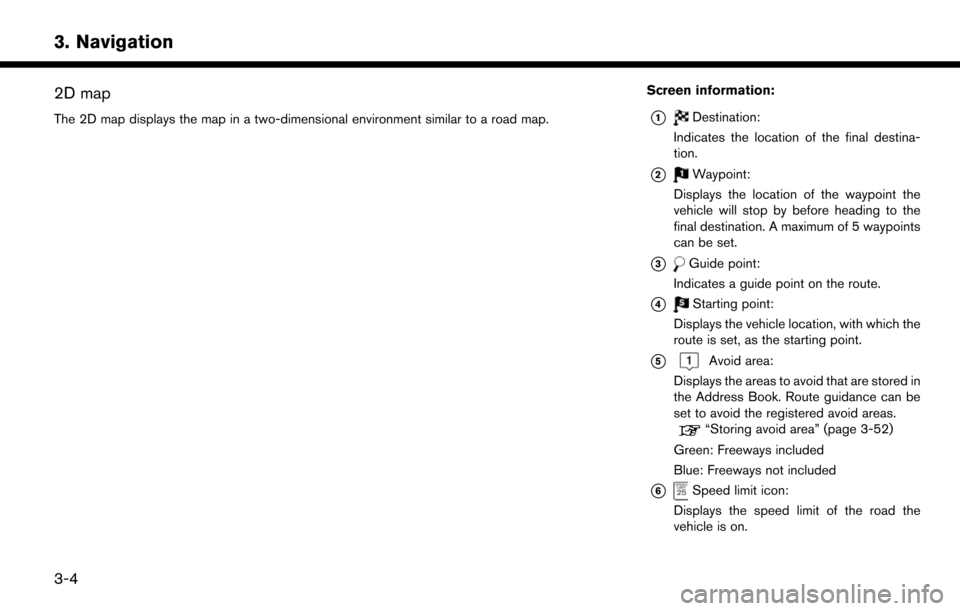
2D map
The 2D map displays the map in a two-dimensional environment similar to a road map.
Screen information:
*1Destination:
Indicates the location of the final destina-
tion.
*2Waypoint:
Displays the location of the waypoint the
vehicle will stop by before heading to the
final destination. A maximum of 5 waypoints
can be set.
*3Guide point:
Indicates a guide point on the route.
*4Starting point:
Displays the vehicle location, with which the
route is set, as the starting point.
*5Avoid area:
Displays the areas to avoid that are stored in
the Address Book. Route guidance can be
set to avoid the registered avoid areas.
“Storing avoid area” (page 3-52)
Green: Freeways included
Blue: Freeways not included
*6Speed limit icon:
Displays the speed limit of the road the
vehicle is on.
3-4
3. Navigation
Page 65 of 268
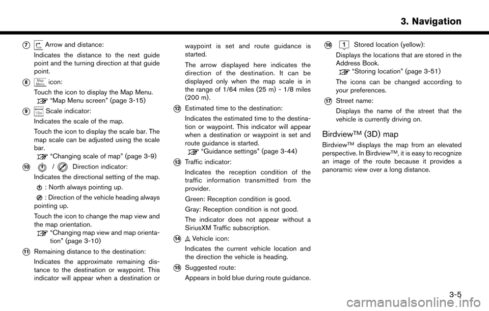
*7Arrow and distance:
Indicates the distance to the next guide
point and the turning direction at that guide
point.
*8icon:
Touch the icon to display the Map Menu.
“Map Menu screen” (page 3-15)
*9Scale indicator:
Indicates the scale of the map.
Touch the icon to display the scale bar. The
map scale can be adjusted using the scale
bar.
“Changing scale of map” (page 3-9)
*10/Direction indicator:
Indicates the directional setting of the map.
: North always pointing up.
: Direction of the vehicle heading always
pointing up.
Touch the icon to change the map view and
the map orientation.
“Changing map view and map orienta-
tion” (page 3-10)
*11Remaining distance to the destination:
Indicates the approximate remaining dis-
tance to the destination or waypoint. This
indicator will appear when a destination or waypoint is set and route guidance is
started.
The arrow displayed here indicates the
direction of the destination. It can be
displayed only when the map scale is in
the range of 1/64 miles (25 m) - 1/8 miles
(200 m) .
*12Estimated time to the destination:
Indicates the estimated time to the destina-
tion or waypoint. This indicator will appear
when a destination or waypoint is set and
route guidance is started.
“Guidance settings” (page 3-44)
*13Traffic indicator:
Indicates the reception condition of the
traffic information transmitted from the
provider.
Green: Reception condition is good.
Gray: Reception condition is not good.
The indicator does not appear without a
SiriusXM Traffic subscription.
*14Vehicle icon:
Indicates the current vehicle location and
the direction the vehicle is heading.
*15Suggested route:
Appears in bold blue during route guidance.
*16Stored location (yellow):
Displays the locations that are stored in the
Address Book.
“Storing location” (page 3-51)
The icons can be changed according to
your preferences.
*17Street name:
Displays the name of the street that the
vehicle is currently driving on.
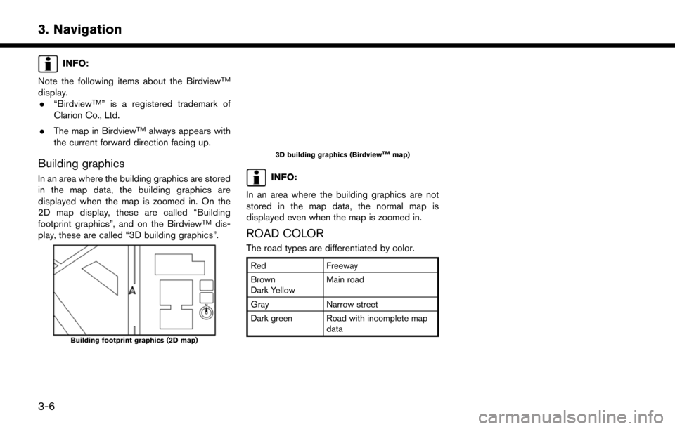
BirdviewTM(3D) map
BirdviewTMdisplays the map from an elevated
perspective. In BirdviewTM, it is easy to recognize
an image of the route because it provides a
panoramic view over a long distance.
3-5
3. Navigation
Page 66 of 268
INFO:
Note the following items about the Birdview
TM
display. . “BirdviewTM” is a registered trademark of
Clarion Co., Ltd.
. The map in Birdview
TMalways appears with
the current forward direction facing up.
Building graphics
In an area where the building graphics are stored
in the map data, the building graphics are
displayed when the map is zoomed in. On the
2D map display, these are called “Building
footprint graphics”, and on the Birdview
TMdis-
play, these are called “3D building graphics”.
Building footprint graphics (2D map)
3D building graphics (BirdviewTMmap)
INFO:
In an area where the building graphics are not
stored in the map data, the normal map is
displayed even when the map is zoomed in.
ROAD COLOR
The road types are differentiated by color.
Red Freeway
Brown
Dark Yellow Main road
Gray Narrow street
Dark green Road with incomplete map data
3-6
3. Navigation