2017 Lexus IS200t sat nav
[x] Cancel search: sat navPage 2 of 342

2
IS_NAVI_EE
This manual explains the operation of the system. Please read this manual carefully to
ensure proper use. Keep this manual in your vehicle at all times.
The screen shots in this document and the actual screens of the system differ depend-
ing on whether the functions and/or a contract existed and the map data available at
the time of producing this document.
In some situations when changing between screens, it may take longer than normal for
the screen to change, the screen may be blank momentarily or noise may be displayed.
Please be aware that the content of this manual may be different from the system in
some cases, such as when the system’s software is updated.
The Navigation System is one of the most technologically advanced vehicle accesso-
ries ever developed. The system receives satellite signals from the Global Positioning
System (GPS) operated by the U.S. Department of Defense. Using these signals and
other vehicle sensors, the system indicates your present position and assists in locating
a desired destination.
The navigation system is designed to select efficient routes from your present starting
location to your destination. The system is also designed to direct you to a destination
that is unfamiliar to you in an efficient manner. Map database is made based on AISIN
AW maps, whose information source comes from HERE maps. The calculated routes
may not be the shortest nor the least traffi c congested. Your own personal local knowl-
edge or “short cut” may at times be faster than the calculated routes.
The navigation system’s database includes Point of Interest categories to allow you to
easily select destinations such as restaurants and hotels. If a destination is not in the da-
tabase, you can enter the street address or a major intersection close to it and the sys-
tem will guide you there.
The system will provide both a visual map and audio instructions. The audio instructions
will announce the distance remaining and the direction to turn when approaching an
intersection. These voice instructions will help you keep your eyes on the road and are
timed to provide enough time to allow you to maneuver, change lanes or slow down.
Please be aware that all current vehicle navigation systems have certain limitations that
may affect their ability to perform properly. The accuracy of the vehicle’s position de-
pends on satellite conditions, road configur ation, vehicle condition or other circum-
stances. For more information on the limitations of the system, refer to page 149.
NAVIGATION AND MULTIMEDIA SYSTEM OWNER’S MANUAL
NAVIGATION SYSTEM (WITH NAVIGATION FUNCTION)
Introduction
Page 149 of 342

149
IS_NAVI_EE
NAVIGATION SYSTEM
3
6. TIPS FOR THE NAVIGATION SYSTEM
1. GPS (GLOBAL POSITIONING SYSTEM)
The Global Positioning System (GPS) de-
veloped and operated by the U.S. Depart-
ment of Defense provides an accurate
current position, normally using 4 or more
satellites, and in some case 3 satellites. The
GPS system has a certain level of inaccura-
cy. While the navigation system compen-
sates for this most of the time, occasional
positioning errors of up to 100 yd. (100 m)
can and should be expected. Generally, po-
sition errors will be corrected within a few
seconds.When the vehicle is receiving signals from
satellites, the “GPS” mark appears at the
top left of the screen.
The GPS signal may be physically obstruct-
ed, leading to inaccurate vehicle position on
the map screen. Tunnels, tall buildings,
trucks, or even the placement of objects on
the instrument panel may obstruct the GPS
signals.
The GPS satellites may not send signals due
to repairs or improvements being made to
them.
Even when the navigation system is receiv-
ing clear GPS signals, the vehicle position
may not be shown accurately or inappropri-
ate route guidance may occur in some cas-
es.
LIMITATIONS OF THE
NAVIGATION SYSTEM
This navigation system calculates the
current position using satellite signals,
various vehicle signals, map data, etc.
However, an accurate position may not
be shown depending on satellite condi-
tions, road configuration, vehicle condi-
tion or other circumstances.
NOTICE
●The installation of window tinting may
obstruct the GPS signals. Most window
tinting contains some metallic content
that will interfere with GPS signal recep-
tion of the antenna in the instrument
panel. We advise against the use of win-
dow tinting on vehicles equipped with
navigation systems.
Page 164 of 342

164
1. BASIC OPERATION
IS_NAVI_EE
1Select the “DSP” tab and select the de-
sired item to be set.1Select the “Settings” tab and select the
desired item to be set.
DSP CONTROL
No.Function
The system adjusts to the optimum
volume and tone quality according
to vehicle speed to compensate for
increased vehicle noise.
This function can create a feeling of
presence.
AUDIO SETTINGS
FunctionPage
FM radio settings200
DAB settings200
Cover art settings201
Gracenote settings201
DVD settings202
Screen size settings165
Display settings165
Video sound input settings201
Video signal settings201
Page 177 of 342

177
3. MEDIA OPERATION
IS_NAVI_EE
AUDIO/VISUAL SYSTEM
4
WA R N I N G
●Conversational speech on some DVDs is recorded at a low volume to emphasize the
impact of sound effects. If you adjust the volume assuming that the conversations represent
the maximum volume level that the DVD will play, you may be startled by louder sound
effects or when you change to a different au dio source. The louder sounds may have a sig-
nificant impact on the human body or pose a driving hazard. Keep this in mind when you
adjust the volume.
INFORMATION
● According to the DVD disc, some menu items can be selected directly. (For details, see the
manual that comes with the DVD disc provided separately.)
● If appears on the screen when a control is selected, the operation relevant to the control
is not permitted.
Page 209 of 342

209
6. TIPS FOR OPERATING THE AUDIO/VISUAL SYSTEM
IS_NAVI_EE
AUDIO/VISUAL SYSTEM
4
�zCD-R/CD-RW discs that have not been
subject to the “finalizing process” (a pro-
cess that allows discs to be played on a
conventional CD player) cannot be played.
�z It may not be possible to play CD-R/CD-
RW discs recorded on a music CD
recorder or a personal computer because
of disc characteristics, scratches or dirt on
the disc, or dirt, condensation, etc. on the
lens of the unit.
�z It may not be possible to play discs
recorded on a personal computer depend-
ing on the application settings and the envi-
ronment. Record with the correct format.
(For details, contact the appropriate appli-
cation manufacturers of the applications.)
�z CD-R/CD-RW discs may be damaged by
direct exposure to sunlight, high tempera-
tures or other storage conditions. The unit
may be unable to play some damaged
discs.
�z If you insert a CD-RW disc into the player,
playback will begin more slowly than with a
conventional CD or CD-R disc.
�z Recordings on CD-R/CD-RW cannot be
played using the DDCD (Double Density
CD) system.
Region codes : Some DVD video discs have
the following region code indicating which
countries the DVD video disc can be played
in on this DVD player. If you attempt to play
an inappropriate DVD video disc on this
player, error message appears on the
screen. Even if the DVD video disc does not
have a region code, there are cases when it
cannot be used.
CD-R/RW AND DVD-R/RW
DISCSDVD VIDEO DISCS
This DVD player conforms to NTSC/
PAL colour TV formats. DVD video
discs conforming to another format such
as SECAM cannot be used.
CodeCountry
ALLAll countries
2Europe
5Eastern Europe, Russia
Page 210 of 342

210
6. TIPS FOR OPERATING THE AUDIO/VISUAL SYSTEM
IS_NAVI_EE
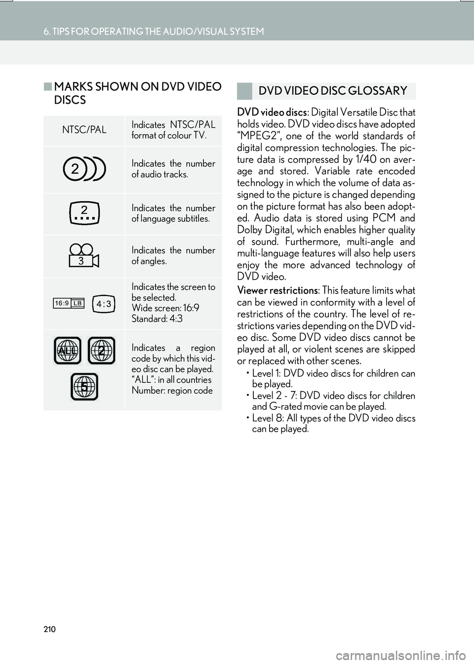
■MARKS SHOWN ON DVD VIDEO
DISCS
DVD video discs : Digital Versatile Disc that
holds video. DVD video discs have adopted
“MPEG2”, one of the world standards of
digital compression technologies. The pic-
ture data is compressed by 1/40 on aver-
age and stored. Variable rate encoded
technology in which the volume of data as-
signed to the picture is changed depending
on the picture format has also been adopt-
ed. Audio data is stored using PCM and
Dolby Digital, which enables higher quality
of sound. Furthermore, multi-angle and
multi-language features will also help users
enjoy the more advanced technology of
DVD video.
Viewer restrictions : This feature limits what
can be viewed in conformity with a level of
restrictions of the country. The level of re-
strictions varies depending on the DVD vid-
eo disc. Some DVD video discs cannot be
played at all, or violent scenes are skipped
or replaced with other scenes.
• Level 1: DVD video discs for children can be played.
• Level 2 - 7: DVD video discs for children and G-rated movie can be played.
• Level 8: All types of the DVD video discs can be played.
NTSC/PALIndicates NTSC/PAL
format of colour TV.
Indicates the number
of audio tracks.
Indicates the number
of language subtitles.
Indicates the number
of angles.
Indicates the screen to
be selected.
Wide screen: 16:9
Standard: 4:3
Indicates a region
code by which this vid-
eo disc can be played.
“ALL”: in all countries
Number: region code
DVD VIDEO DISC GLOSSARY
Page 217 of 342

217
6. TIPS FOR OPERATING THE AUDIO/VISUAL SYSTEM
IS_NAVI_EE
AUDIO/VISUAL SYSTEM
4
ERROR MESSAGES
ModeMessageExplanation
CD/DVD
“No disc found.”It indicates that there is no disc in the DVD player.
“Check DISC”
It indicates that the disc is dirty, damaged, or it was
inserted upside down. Clean the disc or insert it
correctly.
It indicates a disc which is not playable is inserted.
“DISC error”There is a trouble inside the system.
Eject the disc.
“Region code error”It indicates that the DVD region code is not set
properly.
USB
“USB error”This indicates a problem in the USB memory or its
connection.
“No music files found.”This indicates that no MP3/WMA/AAC files are
included in the USB memory.
“No video files found.”This indicates that no video files are included in the
USB memory.
“No image files found.”This indicates that no image files are included in the
USB memory.
iPod
“iPod error.”This indicates a problem in the iPod or its connec-
tion.
“No music files found.”This indicates that there is no music data in the iPod.
“No video files found.”This indicates that no video files are included in the
iPod.
“Check the iPod firm-
ware version.”This indicates that the software version is not com-
patible. Perform the iPod firmware updates and try
again.
“iPod authorisation un-
successful.”This indicates that it failed to authorize the iPod.
Please check your iPod.
Bluetooth®
Audio“Music tracks not sup-
ported. Check your
portable player.”This indicates a problem in the Bluetooth® device.