Page 182 of 352

182
HIGHLANDER_Navi_U
1. USEFUL INFORMATION
1. RECEIVING WEATHER INFORMATION
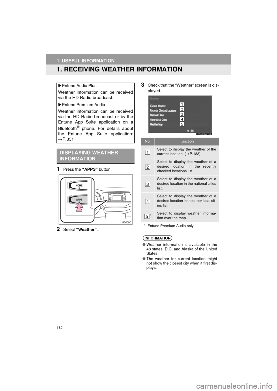
1Press the “APPS” button.
2Select “Weather” .
3Check that the “Weather” screen is dis-
played.
Entune Audio Plus
Weather information can be received
via the HD Radio broadcast.
Entune Premium Audio
Weather information can be received
via the HD Radio broadcast or by the
Entune App Suite application on a
Bluetooth
® phone. For details about
the Entune App Suite application:
P.331
DISPLAYING WEATHER
INFORMATION
No.Function
Select to display the weather of the
current location. ( P.183)
Select to display the weather of a
desired location in the recently
checked locations list.
Select to display the weather of a
desired location in the national cities
list.
Select to display the weather of a
desired location in the other local cit-
ies list.
*Select to display weather informa-
tion over the map.
*: Entune Premium Audio only
INFORMATION
● Weather information is available in the
48 states, D.C. and Alaska of the United
States.
● The weather for current location might
not show the closest city when it first dis-
plays.
Page 184 of 352
184
1. USEFUL INFORMATION
HIGHLANDER_Navi_U
2. RECEIVING TRAFFIC MAP INFORMATION*
1Press the “APPS” button.
2Select “Traffic” .
3Check that the “Traffic Map” screen is
displayed.Traffic map information can be re-
ceived via the HD Radio.
DISPLAYING TRAFFIC MAP
INFORMATION
*: Entune Audio Plus only
No.Function
Current position of your car
Traffic information line
The line color means the following:
Red: Heavy congestion
Yellow: Moderate traffic
Green: Freely flowing traffic
INFORMATION
●Traffic map information is available in
the 48 states, D.C. and Alaska of the
United States.
Page 185 of 352
185
1. USEFUL INFORMATION
HIGHLANDER_Navi_U
INFORMATION
5
3. DATA SERVICES SETTINGS*
1Press the “APPS” button.
2Select “Setup” .
3Select “HD Data” .
4Select the desired item to be set.
Select a checkbox on the right to set.
SETTING DOWNLOAD
METHODS
Data service information, which is
comprised of traffic information and
weather information, can be received
via HD Radio broadcast and by the En-
tune App Suite application on a
Bluetooth
® phone. The receiving meth-
od can be set to both or only via HD
Radio broadcast. For details about the
Entune App Suite application: P.331
*: Entune Premium Audio only
No.Function
Select to receive data service infor-
mation via both HD Radio broadcast
and the Entune App Suite applica-
tion on a Bluetooth
® phone. When
both methods are available, HD Ra-
dio broadcast will be selected.
Select to receive data only via HD
Radio broadcast.
INFORMATION
● These settings are available in the 48
states, D.C. and Alaska of the United
States.
Page 216 of 352

216
3. INTUITIVE PARKING ASSIST
HIGHLANDER_Navi_U
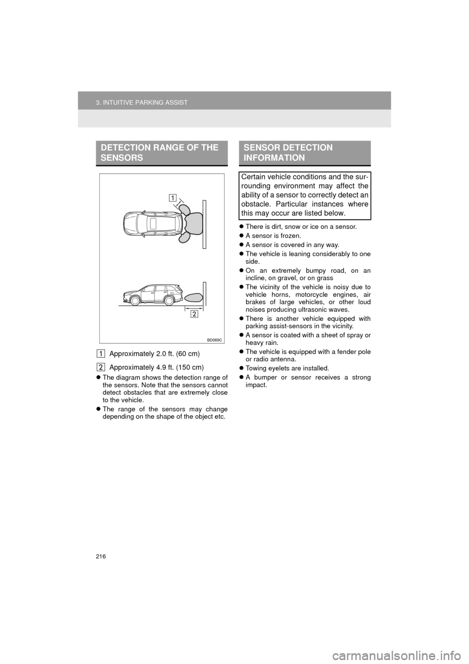
Approximately 2.0 ft. (60 cm)
Approximately 4.9 ft. (150 cm)
The diagram shows the detection range of
the sensors. Note that the sensors cannot
detect obstacles that are extremely close
to the vehicle.
The range of the sensors may change
depending on the shape of the object etc.
There is dirt, snow or ice on a sensor.
A sensor is frozen.
A sensor is covered in any way.
The vehicle is leaning considerably to one
side.
On an extremely bumpy road, on an
incline, on gravel, or on grass
The vicinity of the vehicle is noisy due to
vehicle horns, motorcycle engines, air
brakes of large vehicles, or other loud
noises producing ultrasonic waves.
There is another vehicle equipped with
parking assist-sensors in the vicinity.
A sensor is coated with a sheet of spray or
heavy rain.
The vehicle is equipped with a fender pole
or radio antenna.
Towing eyelets are installed.
A bumper or sensor receives a strong
impact.
DETECTION RANGE OF THE
SENSORSSENSOR DETECTION
INFORMATION
Certain vehicle conditions and the sur-
rounding environment may affect the
ability of a sensor to correctly detect an
obstacle. Particular instances where
this may occur are listed below.
Page 223 of 352

223
1. PHONE OPERATION (HANDS-FREE SYSTEM FOR CELLULAR PHONES)
HIGHLANDER_Navi_U
PHONE
7
2. SOME BASICS
The hands-free system enables calls
to be made and received without hav-
ing to take your hands off the steering
wheel.
This system supports Bluetooth
®.
Bluetooth® is a wireless data system
that enables cellular phones to be used
without being connected by a cable or
placed in a cradle.
The operating procedure of the phone
is explained here.
WA R N I N G
● While driving, do not use a cellular
phone or connect the Bluetooth® phone.
● Your audio unit is fitted with Bluetooth
®
antennas. People with implantable car-
diac pacemakers, cardiac resynchroni-
zation therapy-pacemakers or
implantable cardioverter defibrillators
should maintain a reasonable distance
between themselves and the Bluetooth
®
antennas. The radio waves may affect
the operation of such devices.
● Before using Bluetooth
® devices, users
of any electrical medical device other
than implantable cardiac pacemakers,
cardiac resynchronization therapy-pace-
makers or implantable cardioverter
defibrillators should consult the manu-
facturer of the device for information
about its operation under the influence
of radio waves. Radio waves could have
unexpected effects on the operation of
such medical devices.
NOTICE
● Do not leave your cellular phone in the
vehicle. The temperature inside may rise
to a level that could damage the phone.
INFORMATION
● If your cellular phone does not support
Bluetooth®, this system cannot function.
● In the following conditions, the system
may not function:
• The cellular phone is turned off.
• The current position is outside the
communication area.
• The cellular phone is not connected.
• The cellular phone has a low battery.
● When using Bluetooth
® audio and
hands-free at the same time, the follow-
ing problems may occur:
• The Bluetooth
® connection may be
cut.
• Noise may be heard on the Bluetooth
®
audio playback.
REGISTERING/CONNECTING
A Bluetooth® PHONE
To use the hands-free system for cellu-
lar phones, it is necessary to register a
cellular phone with the system.
( P.44)
Bluetooth® PHONE CONDITION
DISPLAY
The condition of the Bluetooth
® phone
appears on the upper right side of the
screen. ( P.18)
Page 259 of 352

259
3. WHAT TO DO IF...
HIGHLANDER_Navi_U
PHONE
7
Even though all con-
ceivable measures
have been taken, the
symptom status does
not change.
The cellular phone
is not close enough
to this system.Bring the cellular
phone closer to this
system.
Radio interference
has occurred.Turn off Wi-Fi® devices
or other devices that
may emit radio waves.
The cellular phone
is the most likely
cause of the symp-
tom.
Turn the cellular phone
off, remove and rein-
stall the battery pack,
and then restart the
cellular phone.
Enable the cellular
phone’s Bluetooth®
connection.
Disable the Wi-Fi®
connection of the cellu-
lar phone.
Stop the cellular
phone’s security soft-
ware and close all ap-
plications.
Before using an appli-
cation installed on the
cellular phone, careful-
ly check its source and
how its operation might
affect this system.
: For details, refer to the owner’s manual that came with the cellular phone.
SymptomLikely causeSolution
Page
Cellular
phoneThis
system
Page 262 of 352
262
HIGHLANDER_Navi_U
1. BASIC OPERATION
1. QUICK REFERENCE
MAP SCREEN
To display this screen, press the “APPS” button, then select “Navigation” on the
“Apps” screen.
No.NameFunctionPage
2D North-up, 2D
heading-up or 3D
heading-up sym-
bolIndicates whether the map orientation is set to
north-up or heading-up. The letter(s) beside this
symbol indicate the vehicle’s heading direction
(e.g. N for north). In 3D map, only a heading-up
view is available.
266
Options buttonSelect to display the “Navigation Options” screen.264
“GPS” mark
(Global Position-
ing System)Shows that the vehicle is receiving signals from
the GPS.323
Traffic indicator
Shows that traffic information is received. Select
to start voice guidance for traffic information.
When traffic information is received via HD Radio
broadcast, HD mark is displayed on the right.
274
Scale indicatorThis figure indicates the map scale.265
Page 276 of 352
276
1. BASIC OPERATION
HIGHLANDER_Navi_U
1Select “Options” on the map screen.
2Select “Map Information” .
3Select “Traffic Information” .
When set to on, the indicator will illumi-
nate.
4Check that the traffic information is dis-
played.
DISPLAYING TRAFFIC
INFORMATION ON THE MAPNo.Information/Function
The icons show traffic incident, road
repair, traffic obstacles, etc. Select to
display traffic information and start
voice guidance for the traffic informa-
tion.
The color of the arrow changes de-
pending on the traffic information re-
ceived.
The indicator is displayed as follows.
: Traffic information has
been received.
: Traffic information has
been received via HD Radio broad-
cast.
No icon: Traffic information has not
been received.
INFORMATION
● Traffic information may take some time
to load after the system is turned on.