2014 SUBARU OUTBACK maps
[x] Cancel search: mapsPage 5 of 106

Navigation 77
Read First
This software is designed for optimum performance when
used for car navigation. It does not need a stylus for
operation. You can easily use buttons and maps on the screen
by touching them with the tip of your finger.
When you start the navigation software for the first time, the
initial settings screen is automatically displayed. Follow the
steps below to use the initial settings screen.
1Confirm the end-user license agreement. Touch
(Accept) to continue.
2The Setup Wizard starts. Touch (Next) to continue.
3Select the language and narrator you want to use for
voice guidance messages. Touch (Next) to
continue. You can change this at any time from Sound
and Warnings settings. (See Page 155.)
• When the TTS Voice mode is selected, the voice control
navigation and street guidance can be used. These functions
cannot be used when the Natural Voice mode is selected.
Accept
Next
Next
Page 92 of 106

164 Navigation
Glossary
2D/3D GPS reception
The GPS receiver uses signals from satellites to calculate its current
position (the user's position), but to acquire a 3D position at least four
signals are necessary, including alti tude. The GPS device may not be
able to acquire signals from four sate llites as they are constantly moving
and obstacles may block satellite signals. Although the accuracy
decreases when only three signals ca n be acquired, and altitude data
cannot be sent, the receiver can ca lculate a latitude and longitude GPS
position. Only 2D reception is possible.
Route being navigated
The route currently being navigated. When a destination is set, the
route will be continuously navigate d until the destination is deleted,
you arrive at the destination, or the software is closed. Also see “Route”.
City center
The center of the city/town is not th e geographical center of the city/
town, but a location set by the cartog rapher. In towns and villages, this
is usually the most important intersec tion, while in larger cities it is
selected from multiple important intersections.
Color design
The color design used for the map an d menu screens differs for daytime
and nighttime. Each design has a different graphic setting, with 2D and
3D each having colors for roads, bl ocks, seas, and lakes, whilst shadow
changes and shadows are displayed differently in 3D mode.
Daytime screen and nighttime scr een designs for the map and menu
are selected one at a time. The desi gn changes automatically when day
becomes night and night becomes day. GPS accuracy
Various factors can contribute to a margin of error between the user's
actual position and the position
acquired from the GPS device. For
example, signal delays in the iono sphere or reflections from objects
around the GPS equipment, can infl uence the accuracy with which the
GPS device can calculate the user's position.
Maps
Although this software uses digita l maps, these are not simply digital
conversions from printed maps. The 2D mode digital map represents
roads in the same way as a traditional printed map, using color
classifications to show streets, roads, and changes in altitude.
In 3D mode, you can confirm differ ences in altitude for mountains,
valleys, highland roads and so on, an d display areas of cities using 3D
landmarks and 3D images of buildings.
The digital map can be used intera ctively. You can zoom in and out
(enlarge/reduce), tilt up and down, an d rotate left and right. By using
navigation that supports GPS, you ca n easily plan your route with the
digital maps.
North Up Map Direction
North Up mode rotates the map so th at North is always at the top of
the map. You can use this direction with Find On Map and so on. Also
see “Heads-up Map Direction”.
Page 94 of 106

166 Navigation
Glossary
•Wide area map, detailed map
The wide area map is a map of a la rge area, and the detailed map is a
map of a small area. The scales of the maps are 1/20,480,000,
1/10,240,000, 1/5,120,000, 1/ 2, 560,000, 1/1,280,000, 1/640,000,
1/320,000, 1/160,000, 1/80,000, 1/40,000, 1/20,000, 1/10,000, and
1/5,000.
• Positioning
The quality of the GPS positioning is displayed in the top right of the
menu screen. The greater the number of displayed symbols, the
higher the precision of the GPS positioning. •
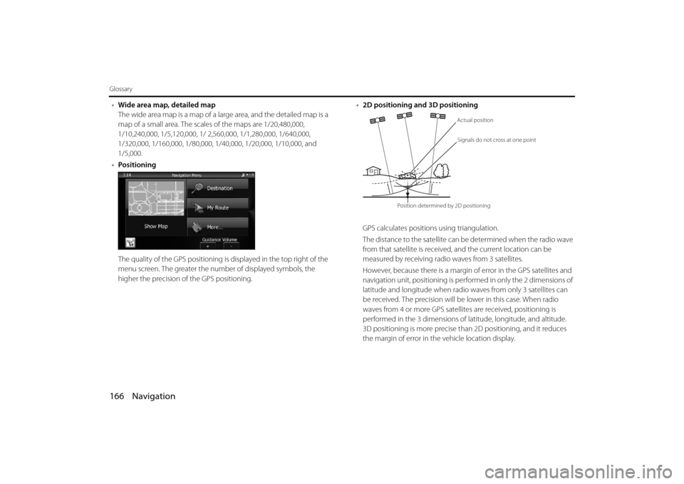
2D positioning and 3D positioning
GPS calculates positions using triangulation.
The distance to the satellite can be determined when the radio wave
from that satellite is received, and the current location can be
measured by receiving radio waves from 3 satellites.
However, because there is a margin of error in the GPS satellites and
navigation unit, positioning is performed in only the 2 dimensions of
latitude and longitude when radio waves from only 3 satellites can
be received. The precision will be lower in this case. When radio
waves from 4 or more GPS satellites are received, positioning is
performed in the 3 dimensions of la titude, longitude, and altitude.
3D positioning is more precise than 2D positioning, and it reduces
the margin of error in the vehicle location display.
Actual position
Signals do not cross at one point
Position determined by 2D positioning
Page 102 of 106

174 Navigation
Further Information
NOTE•Because the GPS satellite is in orbit around the earth, the reception status for
the electromagnetic waves changes depend ing on their position at that point
in time, even if your vehicle is in th e same place. Also, electromagnetic-waves
from satellites near the horizon can be easily influenced by surrounding
obstacles.
• At times, satellites under the control of the US Department of Defence will
intentionally drop positioning accuracy.
Regarding Errors in Current Position Display
The system displays the vehicle current position based on GPS
information and data from various sensors and road maps. However,
when the radiowave signals from GPS satellites are weak or when
signals are received only from two sate llites or less, errors may occur in
the position. Modifying or adjusting the system will not prevent these
errors.
• In underground buil dings and indoor
parking lots • In places with a lot of overgrown
trees and so on
• Under elevated roads • Roads at the base of cliffs and caves
Page 105 of 106

Navigation 177
Further Information
Regarding Roads and Place Name Data
Because road and place names may change after the map data has
been created, there may be times when road and place names do not
match.
When no information is available in the map data, function such as
display of road names, searching for facilities, and route guidance
cannot be used.
When maps are created, land surv eys are conducted and information
about roads improvement and opening is collected to provide the
most accurate information possible. However, modifications in roads,
place names and facilities may be carried out at any time.
Consequently, we cannot guarantee that map data contains no errors
in road positions, configuration and names, or in facility names.
The navigation system includes a func tion to read out names of roads,
intersections, and so on during guidance.
Depending on the selected language , names read out by the system
may not be exactly accurate due to missing information in map data.
Regarding Route Navigation
• It may deviate from the route
navigation when there is a turn at an
intersection etc., and a mistake in the
voice navigation. • When searching for the route, it may
take the long way around.
• The route may need you to make a U-urn during navigation. • When driving on a straight road,
information may be displayed
indicating that you should go
straight ahead. ( When the
intersection shape is not clear and so
on.)
In six tenthsof a mile,
right turm.