2014 MERCEDES-BENZ B-Class Data setting
[x] Cancel search: Data settingPage 90 of 270

COMAND may give differing navigation com-
mands if the actual street/traffic situation
does not correspond with the digital map's
data. For example, if the road layout or the
direction of a one-way street has been
changed.
For this reason, you must always observe
road and traffic rules and regulations during
your journey. Road and traffic rules and reg-
ulations always have priority over the sys-
tem's driving recommendations.
Route guidance begins once a route has been calculated (Y page 69).
COMAND guides you to your destination by
means of navigation announcements in the
form of audible navigation announcements
and route guidance displays.
The route guidance displays can be seen if the
display is switched to navigation mode.
If you do not follow the navigation announce- ments or if you leave the calculated route,
COMAND automatically calculates a new
route to the destination.
If the digital map contains the corresponding
information, the following applies:
R during route guidance, COMAND tries to
avoid roads with restricted access. Those
roads, for example, that are closed to
through-traffic.
R roads that have time restrictions (e.g.
closed on Sundays and public holidays) are considered for route guidance on days
when they are open. For this purpose, the
relevant times must be correctly stored in
the database. Displays during route guidance
Change of direction Changes of direction have three phases:
R preparation phase
R announcement phase
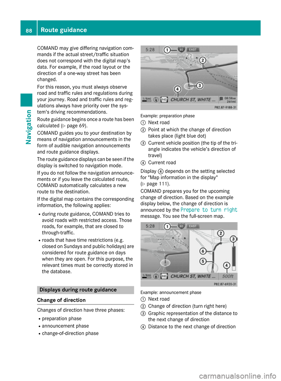
R change-of-direction phase Example: preparation phase
0043
Next road
0044 Point at which the change of direction
takes place (light blue dot)
0087 Current vehicle position (the tip of the tri-
angle indicates the vehicle’s direction of
travel)
0085 Current road
Display 0085depends on the setting selected
for "Map information in the display"
(Y page 111).
COMAND prepares you for the upcoming
change of direction. Based on the example
display below, the change of direction is
announced by the Prepare to turn right Prepare to turn right
message. You see the full-screen map. Example: announcement phase
0043
Next road
0044 Change of direction (turn right here)
0087 Graphic representation of the distance to
the next change of direction
0085 Distance to the next change of direction 88
Route guidanceNavigation
Page 94 of 270

The volume of an active audio or video
source is automatically reduced during a
navigation announcement.
R Gas on Reserve
Gas on Reserve
Once you have reached reserve fuel
level, you will see a prompt asking
whether you wish to start the search for a
gas station (Y page 76).
X Select the function and press 0098to confirm.
Switch the function on 0073or off 0053.
Setting the volume manually X
Adjust the volume using the 0043control
knob during a navigation announcement.
or X Select RPT
RPT in the map view with the menu
shown and adjust the volume using the 0043
control knob.
Announce Street Names If the function is switched on, the name of the
street which you are turning into is
announced.
Announcements are not made in the chosen
language in all countries. They are made when
relevant street names for the selected lan-
guage are available in the database.
X To switch to navigation mode: press the
00BE button.
X To show the menu: press0098the COMAND
controller.
X Select Navi Naviin the main function bar by
sliding 00970052the COMAND controller and
press 0098to confirm.
X Select Announce
Announce Street
StreetNames
Namesand press
0098 to confirm.
The function is switched on 0073or off 0053,
depending on the previous status. Exit route guidance
Canceling or continuing route guidance X
To switch to navigation mode: press the
00BE button.
X To show the menu: press0098the COMAND
controller.
X Select Destination
Destination in the navigation sys-
tem menu bar by turning 00790052007Athe
COMAND controller and press 0098to con-
firm.
X To cancel route guidance: selectCancel
Cancel
Route Guidance
Route Guidance and press0098to confirm.
or X To continue route guidance: selectCon‐
Con‐
tinue Route Guidance
tinue Route Guidance and press0098to
confirm.
COMAND calculates the route.
Destination or area of destination
reached When you reach your destination, COMAND
displays a checkered flag and route guidance
is automatically ended.
If the destination is not in close proximity to a
digitized street, the Area Areaof
ofdestination
destination
reached
reached message appears when the desti-
nation is reached. Influencing route guidance
Avoiding a section of the route blocked
by a traffic jam This function blocks a section of the route
ahead of you. You can set the length of the
blocked route section. If possible, COMAND
calculates a detour around the blocked sec-
tion of the route.
X To switch to navigation mode: press the
00BE button.
X To show the menu: press0098the COMAND
controller. 92
Route guidanceNavigation
Page 110 of 270

X
Select Delete
Delete and press 0098to confirm.
A prompt appears asking whether the entry
should be deleted.
X Select Yes
Yes orNo
No and press 0098to confirm.
If you select Yes
Yes, the entry is deleted.
If you select No
No, the process will be can-
celed. Map operation and map settings
General notes
Company logos displayed on the map are
trademarks of the respective companies and
used solely for the purpose of indicating the
locations of these companies. The use of such
logos on the map does not indicate approval
of, support of or advertising by these compa-
nies for the navigation system itself. Setting the map scale
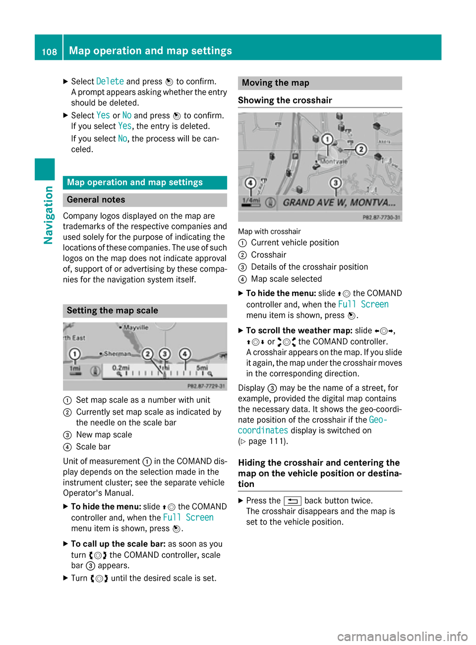
0043
Set map scale as a number with unit
0044 Currently set map scale as indicated by
the needle on the scale bar
0087 New map scale
0085 Scale bar
Unit of measurement 0043in the COMAND dis-
play depends on the selection made in the
instrument cluster; see the separate vehicle
Operator's Manual.
X To hide the menu: slide00970052the COMAND
controller and, when the Full Screen
Full Screen
menu item is shown, press 0098.
X To call up the scale bar: as soon as you
turn 00790052007A the COMAND controller, scale
bar 0087appears.
X Turn 00790052007A until the desired scale is set. Moving the map
Showing the crosshair Map with crosshair
0043
Current vehicle position
0044 Crosshair
0087 Details of the crosshair position
0085 Map scale selected
X To hide the menu: slide00970052the COMAND
controller and, when the Full Screen Full Screen
menu item is shown, press 0098.
X To scroll the weather map: slide009500520096,
009700520064 or009100520078 the COMAND controller.
A crosshair appears on the map. If you slide it again, the map under the crosshair movesin the corresponding direction.
Display 0087may be the name of a street, for
example, provided the digital map contains
the necessary data. It shows the geo-coordi-
nate position of the crosshair if the Geo-
Geo-
coordinates coordinates display is switched on
(Y page 111).
Hiding the crosshair and centering the
map on the vehicle position or destina-
tion X
Press the 0038back button twice.
The crosshair disappears and the map is
set to the vehicle position. 108
Map operation and map settingsNavigation
Page 113 of 270

played on the map, even if the symbol dis-
play is switched on.
X To exit the menu: press the003Dback
button.
Selecting map information Map information in the display
During route guidance, you can have map
information shown at the bottom edge of the
display.
X To show the menu: press0098the COMAND
controller.
X Select Navi
Navi in the main function bar by
sliding 00970052and turning 00790052007Athe COMAND
controller and press 0098to confirm.
X Select Map MapSettings
Settings and press0098to con-
firm.
The map settings menu appears.
X Select Text Information On Map Text Information On Map and
press 0098to confirm.
A 003B dot indicates the current setting.
X Select Current Street
Current Street ,Geo-coordi‐
Geo-coordi‐
nates
nates orNone
None and press 0098to confirm.
X To exit the menu: slide009500520096 the COMAND
controller. Road display
0043
Road names or numbers, e.g. for high-
ways Geo-coordinate display
0043
Current height above average sea level
(rounded to the nearest 10 m)
0044 Current vehicle position: latitude coordi-
nates
0087 Current vehicle position: longitude coor-
dinates
0085 Number of GPS satellites currently being
used
There must be sufficient GPS reception for all
displays to be shown. If this is not the case,
the display will be grayed out. Height dis-
play 0043may vary from the actual value,
because the navigation system uses the GPS
signals for the calculation.
During the "Move map" function, you will see
the geo-coordinates of the crosshair position. Height display 0043and number of satellites
used 0085are not displayed. Display switched off
0043
Current map orientation
While moving the map, you will see additional data, depending on the crosshair position, if
the digital map supports this data. A street
name, for example, can be shown here
(Y page 108).
Coordinates on the map X
To show the menu: press0098the COMAND
controller. Map operation and map settings
111Navigation Z
Page 115 of 270

Example: city model
Switching city view on/off
When the city model is switched on, the map
shows buildings in 3D.
X To show the menu: press0098the COMAND
controller.
X Select Navi Naviin the main function bar by
sliding 00970052and turning 00790052007Athe COMAND
controller and press 0098to confirm.
X Select Map
Map Settings
Settings and press0098to con-
firm.
The map settings menu appears.
X Select City City(3D)
(3D)and press 0098to confirm.
Depending on the previous status, switch
the option on 0073or off 0053.
i The city model is only shown for "Bird's-
eye View" or "3D Map".
It is available in the 0.05 mi and 0.1 mi map
scales.
The data required for displaying buildings is not available for all cities. Example: intersecting roads on city routes/high-
ways
Showing/hiding intersecting streets
If route guidance is inactive, intersecting
streets can be shown on the upper edge of the
display.
X To show the menu: press0098the COMAND
controller.
X Select Navi Naviin the main function bar by
sliding 00970052and turning 00790052007Athe COMAND
controller and press 0098to confirm.
X Select Map
MapSettings
Settings and press0098to con-
firm.
The map settings menu appears.
X Select Next Intersecting Street Next Intersecting Street and
press 0098to confirm.
Depending on the previous status, switch
the option on 0073or off 0053. Map operation and map settings
113Navigation Z
Page 120 of 270

Country-specific information
You can call up information on the traffic con-
ditions in the country you are currently driving
in via the COMAND Internet and online func-
tion.
The availability of information is country-
dependent. Information can include maxi-
mum speeds, driving with low-beam head-
lamps or legal alcohol limits, for example.
X To switch to navigation mode: press the
00BE button.
X To show the menu: press0098the COMAND
controller.
X Select Position Position in the navigation system
menu bar by sliding 00520064and turning 00790052007A
the COMAND controller and press 0098to
confirm.
X Select Country Information
Country Information and press
0098 to confirm.
When the connection has been made, the
available country information appears.
X To return to navigation: press the0038
button. Displaying the map data version
X
To show the map data menu: press0098
the COMAND controller.
X Select Navi
Navi in the main function bar by
sliding 00970052and turning 00790052007Athe COMAND
controller and press 0098to confirm. X
Select Map Version Map Version and press0098to con-
firm.
The number of the map data version is
shown. Information about new versions of
the digital map can be obtained from an
authorized Mercedes-Benz Center. Updating the digital map
Important safety notes G
WARNING
Combustion engines emit poisonous exhaust
gases such as carbon monoxide. Inhaling
these exhaust gases leads to poisoning. There is a risk of fatal injury. Therefore never leave
the engine running in enclosed spaces with-
out sufficient ventilation.
Introduction The digital maps generated by the map soft-
ware become outdated in the same way as
conventional road maps. Optimal route guid-
ance can only be provided by the navigation
system in conjunction with the most up-to-
date map software.
Information about new versions of the digital
map can be obtained from an authorized
Mercedes-Benz Center. You can have the dig-
ital map updated there with a DVD, or you can update it yourself.
Carrying out a manual update i
The update process can take a long time
(over an hour), depending on the size of the digital map. During this time, you will only
be able to switch on radio mode and to
accept incoming calls. The update will be
completed more quickly if the vehicle is
stationary.
If you start the update with the engine
switched off and the starter battery has
insufficient power, COMAND may automat-
ically switch off. This protects the battery. If 118
Additional settingsNavigation
Page 121 of 270

this occurs, restart the update with the
engine running.
X Insert the DVD (Y page 196).
COMAND checks whether the digital map
on the DVD is compatible with the naviga-
tion system and system software.
A prompt then appears asking if you want
to install the database. Versions of the
database currently installed and the data-
base that is to be installed are displayed.
X Select Yes YesorNo
No and press 0098to confirm.
After selecting Yes
Yes, an activation code
must be entered when installing a database
for the first time. You will receive the acti-
vation code when you buy the navigation
DVD.
If you select No No, the process will be can-
celed.
X Enter the activation code.
After entering the activation code cor-
rectly, COMAND starts updating the digital
map. Once the update is finished, you will
see a message.
X To confirm the message: press0098the
COMAND controller.
X Take the DVD out of the slot.
While the update is running, you will see a
message to this effect and a progress bar.
The navigation system is not operational
until the update is complete.
i You cannot eject the DVD during the
update. If you switch off COMAND during
the update, the update is interrupted. It
then continues from where it was interrup-
ted when the system is restarted.
COMAND may prompt you to change the DVD during the update.
X Press the 0062load/eject button.
X Take the DVD out of the slot.
X Insert the requested DVD.
Once the update has been successfully
completed, you will see a message to this
effect. X
To confirm the message: press0098the
COMAND controller.
X Take the DVD out of the slot.
The update is complete.
If the update is not successfully completed, you will see a message that the map updateis not possible.
X To confirm the message: press0098the
COMAND controller.
X Take the DVD out of the slot. Additional settings
119Navigation Z
Page 134 of 270

X
Select Reception Volume
Reception Volume orTransmis‐
Transmis‐
sion Volume
sion Volume and press0098to confirm.
X Select a volume setting by turning 00790052007Athe
COMAND controller.
X To close the setting scale: press0098or
slide 009500520096 .
i Incorrect settings may have an impact on
the quality of calls. Using the telephone
Incoming call
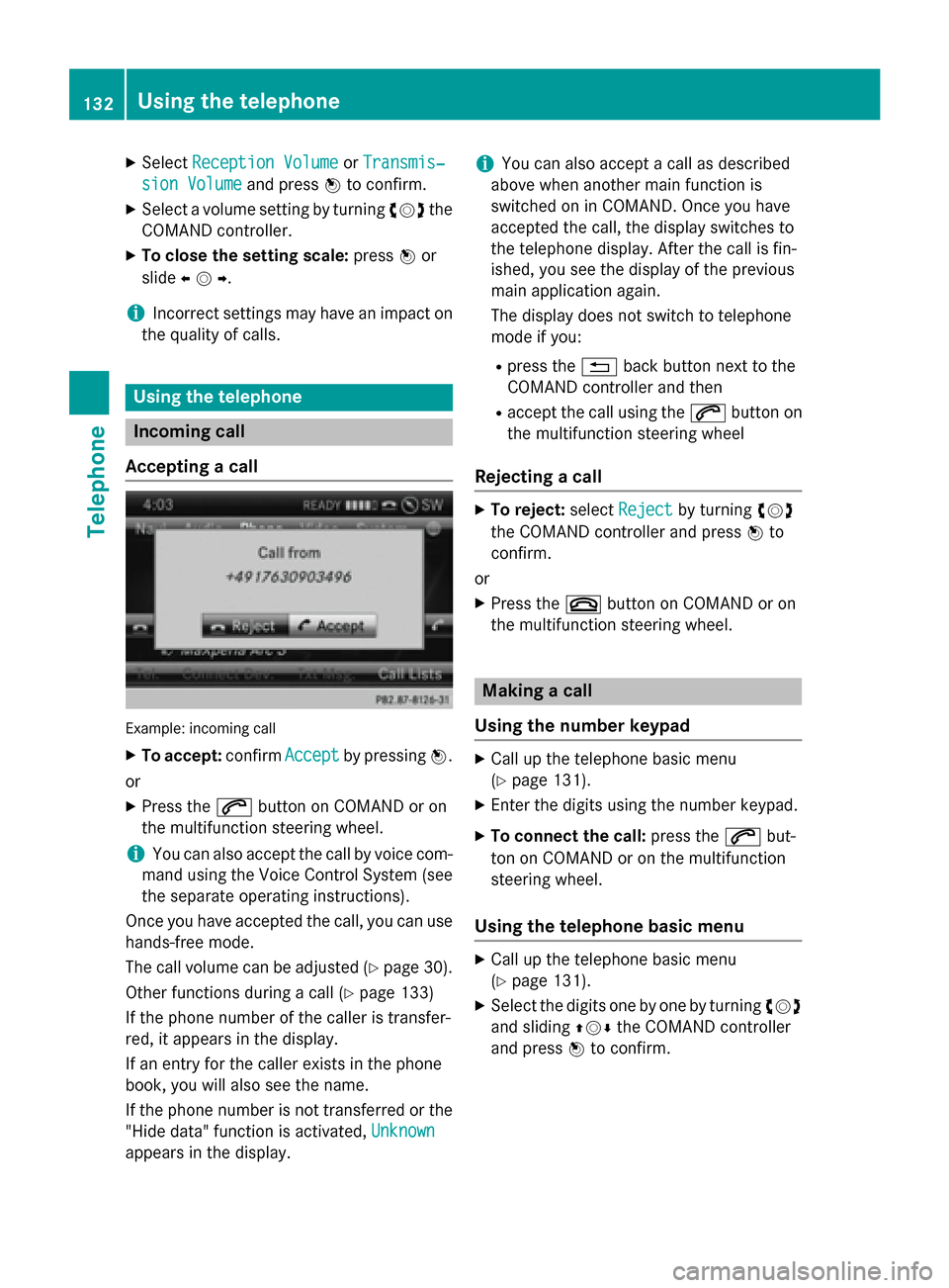
Accepting a call Example: incoming call
X To accept: confirmAccept
Accept by pressing 0098.
or
X Press the 0061button on COMAND or on
the multifunction steering wheel.
i You can also accept the call by voice com-
mand using the Voice Control System (see
the separate operating instructions).
Once you have accepted the call, you can use
hands-free mode.
The call volume can be adjusted (Y page 30).
Other functions during a call (Y page 133)
If the phone number of the caller is transfer-
red, it appears in the display.
If an entry for the caller exists in the phone
book, you will also see the name.
If the phone number is not transferred or the
"Hide data" function is activated, Unknown Unknown
appears in the display. i
You can also accept a call as described
above when another main function is
switched on in COMAND. Once you have
accepted the call, the display switches to
the telephone display. After the call is fin-
ished, you see the display of the previous
main application again.
The display does not switch to telephone
mode if you:
R press the 0038back button next to the
COMAND controller and then
R accept the call using the 0061button on
the multifunction steering wheel
Rejecting a call X
To reject: selectReject Reject by turning 00790052007A
the COMAND controller and press 0098to
confirm.
or
X Press the 0076button on COMAND or on
the multifunction steering wheel. Making a call
Using the number keypad X
Call up the telephone basic menu
(Y page 131).
X Enter the digits using the number keypad.
X To connect the call: press the0061but-
ton on COMAND or on the multifunction
steering wheel.
Using the telephone basic menu X
Call up the telephone basic menu
(Y page 131).
X Select the digits one by one by turning 00790052007A
and sliding 009700520064the COMAND controller
and press 0098to confirm. 132
Using the telephoneTelephone