Page 39 of 274

3. Heater and air conditioner
3-8
INFO:
The automatic air recirculation mode can be
activated under the following conditions.
.The air flow control is not in the windshield
defrosting mode (the indicator light on
<
> is turned off).
.The outside temperature is approximately
32 8F(0 8C) or above.
Ion control:
The Advanced Climate Control system unit
generates highly concentrated Plasmaclus-
ter
®ions into the air blown from the
ventilators to reduce odor absorbed into
the interior trim and to suppress airborne
bacteria. The high-density Plasmacluster
®
ions also have a proven skin moisture
preserving effect.
The Plasmacluster
®icon on the CLIMATE
screen indicates the status of the Plas-
macluster
®ion emission from the system
and changes with the amount of the air
flow.
OPERATING TIPS
. The sensors*Aand*Bon the instru-
ment panel helps maintain a constant
temperature. Do not put anything on or
around these sensors. .
When the engine coolant temperature
and outside air temperature are low,
the air flow from the foot outlets may
not operate. This is not a malfunction.
After the coolant temperature warms
up, air will flow normally from the foot
outlets.
. A visible mist may be seen coming from
the ventilators in hot, humid conditions
as the air is cooled rapidly. This does
not indicate a malfunction.
IN-CABIN MICROFILTER
With Advanced Climate Control system:
The Climate Control system is equipped
with a natural grape seed polyphenol filter
that collects and neutralizes dirt, pollen,
dust, etc. To make sure that the air
conditioner heats, defogs and ventilates
efficiently, replace the filter in accordance
with the maintenance schedule in the
INFINITI Service and Maintenance Guide.
To replace the filter, contact an INFINITI
retailer.
The filter should be replaced if the air flow
decreases significantly or if windows fog
up easily when operating the heater or air
conditioner.
Page 202 of 274

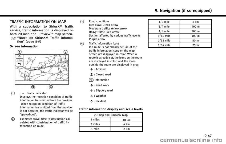
TRAFFIC INFORMATION ON MAP
With a subscription to SiriusXM Traffic
service, traffic information is displayed on
both 2D map and Birdview
TMmap screen.“Notes on SiriusXM Traffic informa-
tion”(page 8-9)
Screen information
*1Traffic indicator:
Displays the reception condition of traffic
information transmitted from the provider.
When reception condition of traffic
information transmitted from the provider
is not detected, the traffic indicator will be
“grayed-out”.
*2Estimated travel time to destination cal-
culated with consideration of traffic in-
formation on route.
*3Road conditions
Free Flow: Green arrow
Moderate traffic: Yellow arrow
Heavy traffic: Red arrow
Section affected by serious traffic event:
Purple arrow
*4Traffic information icon:
If a route is not already set, all of the
traffic information icons on the map
screen are displayed in color. When a
route is already set, the icons on the route
are displayed in color, and the icons
outside the route are displayed in gray.
: Accident
: Closed road
: Information
: Road work
: Slippery road
: Weather
: Incident
Traffic information display and scale levels
2D map and Birdview Map
5 miles 10 km
2 miles 4 km
1 mile 2 km 1/2 mile
1 km
1/4 mile 400 m
1/8 mile 200 m
1/16 mile 100 m
1/32 mile 50 m
1/64 mile 25 m
9. Navigation (if so equipped)
9-47
Page 217 of 274

9. Navigation (if so equipped)
9-62
*When driving on a road not displayed
on the map screen or a road that has
been changed due to additional con-
struction or other reasons.
*When the GPS positioning accuracy is
low.
INFO:
.
The vehicle icon may be misaligned when
starting the vehicle just after the READY to
drive indicator light is ON.
.The vehicle icon may also be misaligned if
different sized tires or tire chains are
installed.
.The system has a function that automati-
cally corrects the vehicle icon position when
it is misaligned from the actual position.
.Vehicle position correction by GPS may not
function when the vehicle is stopped.
.If the vehicle icon position does not return
to normal even after driving for a while,
correct the vehicle icon position manually.
Detailed Map Coverage Areas (MCA)
for navigation system
This system is designed to help guiding to
the destination, and it also performs other
functions as outlined in this manual.
However, the system must be used safely
and properly. Information concerning road
conditions, traffic signs and the availability
of services may not always be up-to-date.
The system is not a substitute for safe,
proper and legal driving. Map data covers select metropolitan areas
in the United States and Canada.
Map data includes two types of areas:
“
Detailed coverage areas” providing all
detailed road data and other areas show-
ing “Main roads only”.
INFO:
Detailed map data is not available in many
areas and is generally limited to select major
metropolitan areas.
When gray road is displayed on
map
.When you are driving on a road
displayed in gray after the vehicle has
deviated from the suggested route
during route guidance, automatic re-
routing may not start immediately.
. The navigation system does not provide
route guidance for roads displayed in
dark green. Therefore, if the destination
is set on a road displayed in dark
green, the enlarged map display will
return to the ordinary map screen at
some point on a suggested route that is
near the destination. Also, voice gui-
dance will stop at some point on a