Page 199 of 274

9. Navigation (if so equipped)
9-44
.Traffic flow information (rate of speed
data).
WARNING!
SiriusXM Traffic information is not a sub-
stitute for attentive driving. Traffic conditions
change constantly and emergency situations
can arise without warning. Relying only on
SiriusXM Traffic information may lead to a
collision and could result in serious personal
injury.
NOTE:
Flow information is provided only for roads
equipped with traffic sensors and is not
available in all markets covered by the service.
Flow data may not be available on portions of a
road that is under construction.
SiriusXM Traffic information is available in
limited markets. To subscribe or to check if
this service is available in the area:
call 1-866-635-2349 or see www.siriusxm.
com/siriusxmtraffic
INFO:
If a contract is not completed for SiriusXM Traffic
information service, a message appears, and it
will not be possible to check the information on
the traffic information system.
VIEWING AVAILABLE TRAFFIC INFORMA-
TION
NavTraffic information is a subscription
service offered by SiriusXM Satellite Radio.
This service provides real-time information
regarding traffic flow, accidents, road
construction and other incidents, where
available.
NavTraffic combines information from com-
mercial and public traffic data providers
including government departments of
transportation, police, emergency services,
road sensors, cameras and aircraft reports.
The traffic information is broadcast to the
vehicle by the SiriusXM satellites. Avail-
able traffic information on the route the
driver selected is shown on the navigation
screen so traffic conditions between you
and the destination are known. Three types
of real-time traffic information for major
roadways are shown on the navigation
system:
* Unscheduled traffic data for example,
accidents and disabled vehicles.
* Scheduled traffic data, for example road
construction and road closures.
* Traffic flow information (rate of speed
Page 200 of 274

data).
WARNING!
NavTraffic information is not a substitute for
attentive driving. Traffic conditions change
constantly and emergency situations can
arise without warning. Relying only on
NavTraffic information may lead to a collision
and could result in serious personal injury.
NOTE:
Flow information is provided only for roads
equipped with traffic sensors and is not
available in all markets covered by the service.
Flow data may not be available on portions of a
road that is under construction.
“SiriusXM Travel Link®”(page 8-4)
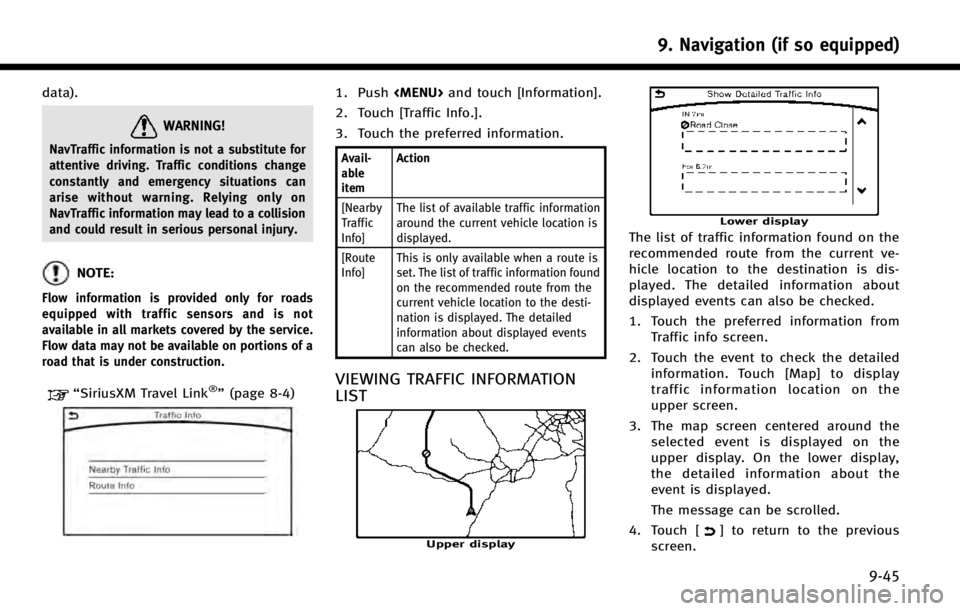
1. Push
Page 214 of 274

GENERAL INFORMATION FOR NAVIGA-
TION SYSYTEM
CURRENT VEHICLE LOCATION
Display of current vehicle location
This navigation system combines the data
obtained from the vehicle (by gyro sensor)
and from GPS (Global Positioning System)
satellites to calculate the current location
of the vehicle. This position is then
displayed throughout route guidance to a
destination.
What is GPS (Global Positioning
System)?
GPS is a position detecting system that
uses satellites deployed by the U.S.
government. This navigation system re-
ceives radio signals from three or more
different satellites that orbit 13,049 miles
(21,000 km) above the earth in space, and
detect the position of the vehicle by
utilizing the principle of triangulation.
Positioning adjustment:
When the system judges that the vehicle
position is not accurate based on vehicle
speed and gyro sensor data calculations,the system will automatically adjust the
position of the vehicle icon using GPS
signals.
Receiving signals from GPS satellites:
The reception of GPS signals can be weak,
depending on the environment. Vehicles in
the following areas/environments may not
receive GPS signals.
*Inside tunnels or parking garages
*In areas with numerous tall buildings
*Under multi-layered highways
9. Navigation (if so equipped)
9-59
Page 259 of 274

11. Troubleshooting guide
11-16
MONITOR SYSTEM (if so equipped)
SymptomPossible cause Possible solution
The image on the display is not clear. The front glass of the camera lens is dirty. Gently wipe off the dirt with a damp soft cloth.
Moisture drops such as rain or snow form on the
camera lens. Gently wipe off the drops with a soft cloth.
Light such as sunlight or a headlight beam from
another vehicle directly enters the camera. This is not a malfunction. It will return normal when
the light disappears.
Moisture condensation occurs in the camera lens
due to rapid temperature change. This is not a malfunction. It will return normal after
driving for a short period of time.
Objects on the display may not be clear in a dark
place or at night. Adjust the brightness or the contrast settings of the
screen.
The image on the display flickers. The vehicle is under fluorescent light.This is not a malfunction.
The colors of the object on the display look different
from those of the actual object. This is a typical phenomenon for cameras. This is not a malfunction.
Image does not appear on the display. The shift lever is not shifted to the“R”position. Shift the shift lever to the “R”position.
[Automatic Display with Sonar] is OFF. Set [Automatic Display with Sonar] to ON
The image appears on the display from the wrong
angle. The trunk is opens.
Close the rear hatch.
The image on the display is not clearly visible. Strong light or reflected light enters the camera. This is not a malfunction.
The sensor is not detective There is ice or snow on the sensor.Flush out ice and snow with warm water.
There is dirt, mud or wax on the sensor. Gently wipe off the dirt with a damp soft cloth.
Vertical lines appear on the image. Strong reflected light from the bumper enters the
camera. This is not a malfunction.
Page 262 of 274
SymptomPossible cause Possible solution
The location of the vehicle icon is mis-
aligned from the actual position. When using tire chains or replacing the tires, speed calcula-
tions based on the speed sensor may be incorrect. Drive the vehicle for a period of time (at
approximately 19 MPH (30 km/h) for about 30
minutes) to automatically correct the vehicle icon
position.
If this does not correct the vehicle icon position,
contact an INFINITI retailer.
The map data has a mistake or is incomplete (the vehicle icon
position is always misaligned in the same area). Updated road information will be included in the
next version of the map data.
11. Troubleshooting guide
11-19