Page 78 of 343
77
Map
3D Angle Adjustment
System Setup
3D Angle AdjustmentHSETTINGS button
Navi Settings
Map
3D Angle Adjustment
Adjust the viewing angle. Rotate i to adjust the angle. Press
u .
Straight Line GuideHSETTINGS button
Navi Settings
Map
Straight Line Guide
Set whether to display a straight guid eline to the destination or waypoint
Rotate i to select an option. Press
u .
The following options are available:
• On (factory default): Displays th e straight guideline on the map.
• Off : Disables the feature.
Page 79 of 343

78
Map
Current Location
System Setup
Current LocationHSETTINGS button
Navi Settings
Map
Current Location
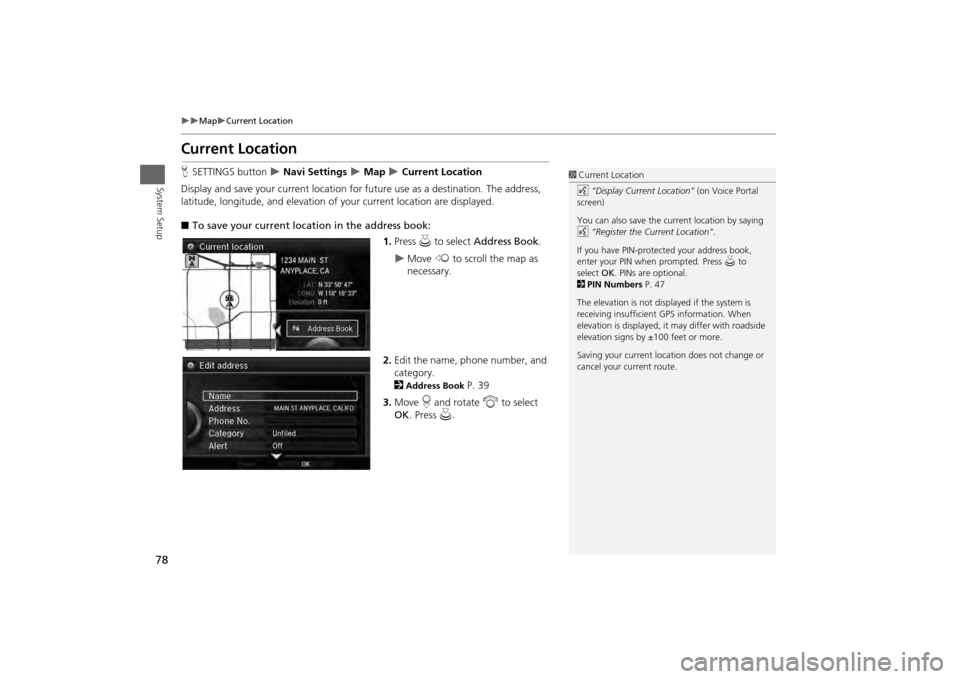
Display and save your current location for fu ture use as a destination. The address,
latitude, longitude, and elevation of your current location are displayed.
■ To save your current loca tion in the address book:
1.Press u to select Address Book .
Move w to scroll the map as
necessary.
2. Edit the name, phone number, and
category.
2Address Book
P. 39
3. Move r and rotate i to select
OK . Press u.
1Current Location
d “Display Current Location” (on Voice Portal
screen)
You can also save the current location by saying
d “Register the Current Location” .
If you have PIN-protec ted your address book,
enter your PIN when prompted. Press u to
select OK. PINs are optional.
2 PIN Numbers P. 47
The elevation is not displayed if the system is
receiving insufficient GPS information. When
elevation is displayed, it may differ with roadside
elevation signs by ±100 feet or more.
Saving your current loca tion does not change or
cancel your current route.
Page 80 of 343
79
Map
Map Legend
System Setup
Map LegendHSETTINGS button
Navi Settings
Map
Map Legend
See an overview of the map lines, areas, routes, traffic information, and navigation
icons.
Move w or y select an item.
The system displays the map
legend.
1Map Legend
A visual guide helps you see the map legend.
2 Map Screen Legend P. 9
2 AcuraLink Real-Time Traffic™ P. 14
Page 81 of 343
80
Map
Map Legend
System Setup
The functions that are available from the map screen depend on the map scale.■Map Scale and Functions
Function
page
Map Scale (top: mile, bottom: metric)
1/20
1/8
1/4
1/2
1
2
5
15
50
150
350
1000
80
200
400
800
1.6
3.2
8
24
80
240
560
1600
Icon displayLandmark icon
9
✔
✔
Exit info.
9
✔
✔
✔
One-way traffic
9
✔
Waypoint
“flag”
10
✔
✔
✔
✔
✔
✔
✔
✔
✔
✔
✔
✔
Traffic incident
9
✔
✔
✔
✔
✔
✔
✔
Map orientationHeading-up
76
✔
✔
✔
✔
✔
✔
✔
✔
✔
✔
✔
North-up
76
✔
✔
✔
✔
✔
✔
✔
✔
✔
✔
✔
✔
3D map
76
✔
✔
✔
✔
✔
✔
✔
✔
✔
✔
✔
OthersTracking dots
119
✔
✔
✔
✔
Unverified road
9
✔
✔
✔
✔
✔
✔
Map features
9
✔
✔
✔
✔
✔
✔
✔
✔
✔
✔
✔
Avoid areas
60
✔
✔
✔
Traffic speed
9
✔
✔
✔
✔
✔
✔
✔
1 Map Scale and Functions
You can change the map scale using voice
commands on the Voice Portal screen (e.g., say
d “Display 2 mile scale”).
2 Map Scale Commands P. 324
You can change between miles or kilometers.
2 Unit Settings P. 34
Page 82 of 343

81
Map
Map Legend
System Setup
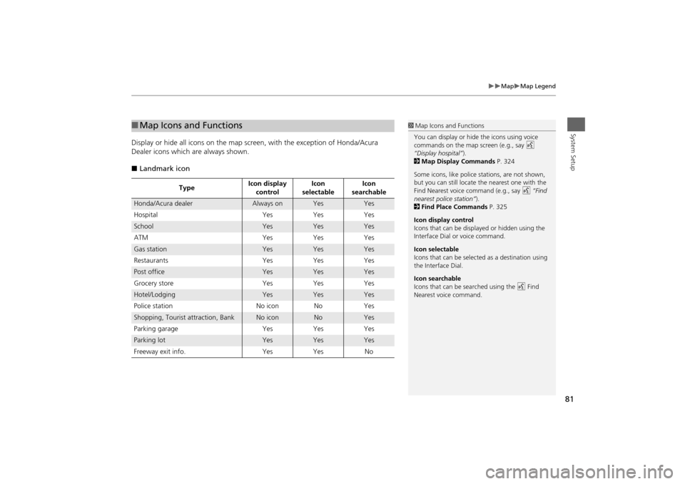
Display or hide all icons on the map screen, with the exception of Honda/Acura
Dealer icons which are always shown.
■ Landmark icon■Map Icons and Functions
Type Icon display
control Icon
selectable Icon
searchable
Honda/Acura dealer
Always on
Yes
Yes
Hospital YesYes Yes
School
Yes
Yes
Yes
ATM YesYes Yes
Gas station
Yes
Yes
Yes
Restaurants YesYes Yes
Post office
Yes
Yes
Yes
Grocery store Yes Yes Yes
Hotel/Lodging
Yes
Yes
Yes
Police station No iconNoYes
Shopping, Tourist attraction, Bank
No icon
No
Yes
Parking garage YesYes Yes
Parking lot
Yes
Yes
Yes
Freeway exit info. Yes Yes No
1 Map Icons and Functions
You can display or hide the icons using voice
commands on the map screen (e.g., say d
“Display hospital” ).
2 Map Display Commands P. 324
Some icons, like police stations, are not shown,
but you can still locate the nearest one with the
Find Nearest voice command (e.g., say d “Find
nearest police station” ).
2 Find Place Commands P. 325
Icon display control
Icons that can be displa yed or hidden using the
Interface Dial or voice command.
Icon selectable
Icons that can be selected as a destination using
the Interface Dial.
Icon searchable
Icons that can be searched using the d Find
Nearest voice command.
Page 83 of 343
82
Map
Map Legend
System Setup
■Traffic icon
Type Icon display
control Icon
selectable Icon
searchable
Traffic incident
Yes
No
Yes
1 Traffic Incident
When you use the Interface Dial to position the
cursor (round red circle) ov er the traffic incident
icon, you can view the summary of the incident.
Press u on the traffic incident icon to view a
pop-up message describing the incident in detail.
Page 84 of 343
83
Map
Display Tracking
System Setup
Display TrackingHSETTINGS button
Navi Settings
Map
Display Tracking
The navigation system can be set to di splay white tracking dots (“breadcrumbs”) on
the map screen.
Rotate i to select an option. Press
u .
The following options are available:
• On : The system displays the white tracking dots.
2
Tracking Dots
P. 119
• Off (factory default): Disables the feature.
H SETTINGS button Navi Settings
Map
Delete Tracking
Rotate i to select Yes. Press u.
■Deleting Tracking Dots
1 Deleting Tracking Dots
When you transfer the vehicle to a third party,
delete the tracking dots.
Page 85 of 343

84
Map
Correct Vehicle Position
System Setup
Correct Vehicle PositionHSETTINGS button
Navi Settings
Map
Correct Vehicle Position
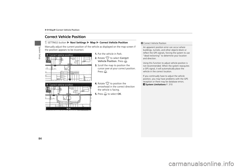
Manually adjust the current position of the vehicle as displayed on the map screen if
the position appear s to be incorrect.
1.Put the vehicle in Park.
2. Rotate i to select Correct
Vehicle Position . Press u.
3. Scroll the map to position the
cursor over at your correct position.
Press u.
4. Rotate i to position the
arrowhead in the correct direction
the vehicle is facing.
5. Press u to select OK.
1Correct Vehicle Position
An apparent position error can occur where
buildings, tunnels, and ot her objects block or
reflect the GPS signals, forcing the system to use
“dead reckoning” to determine your location
and direction.
Using this function to ad just vehicle position is
not recommended. When the system reacquires
a GPS signal, it will automatically place the
vehicle in the correct location.
If you continually have to adjust the vehicle
position, you may have problems with the GPS
reception or there may be database errors.
2 System Limitations P. 310