Page 74 of 328

74
2. ROUTE GUIDANCE
■ROUTES INCLUDING IPD ROADS
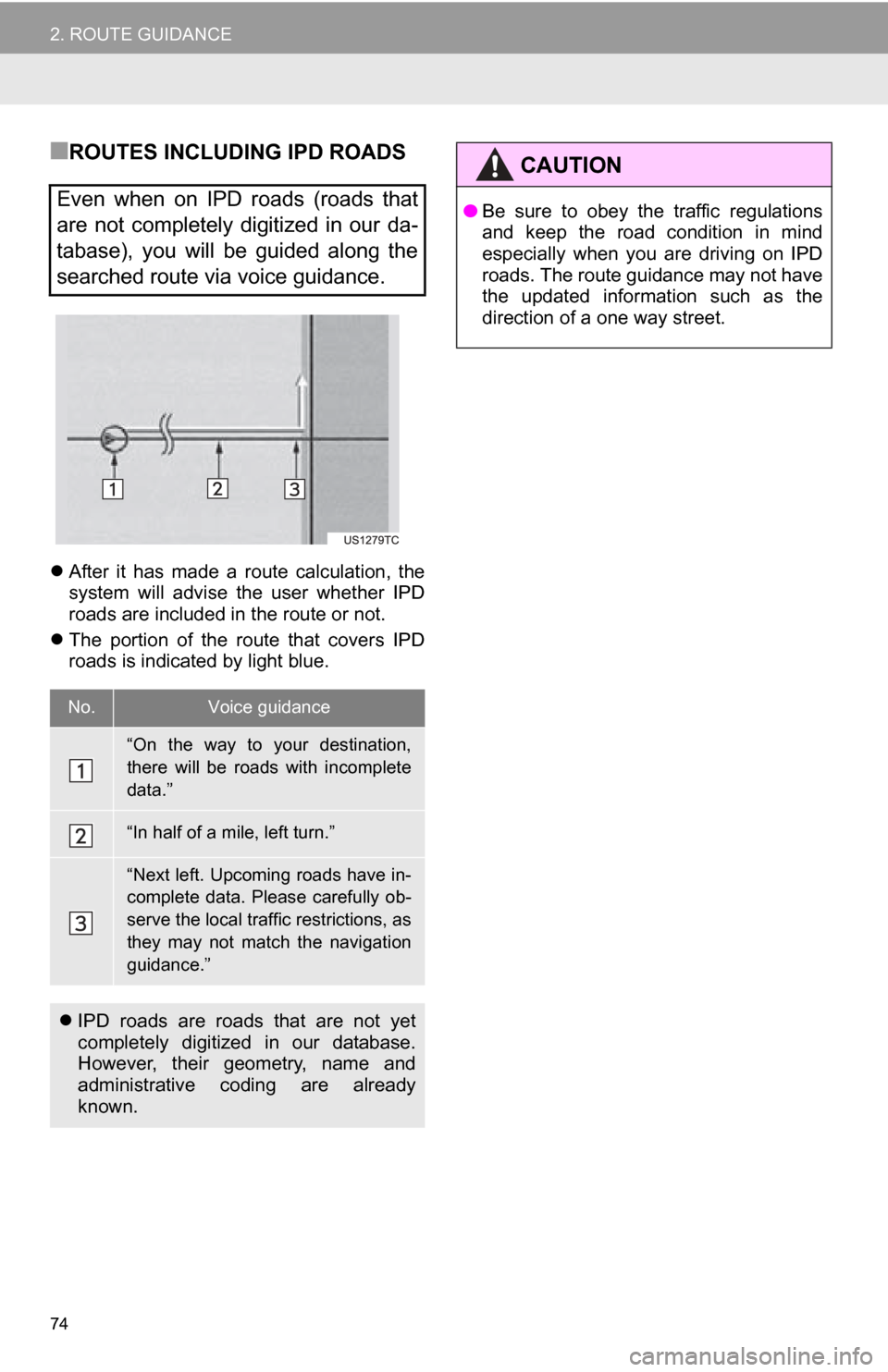
After it has made a route calculation, the
system will advise the user whether IPD
roads are included in the route or not.
The portion of the route that covers IPD
roads is indicated by light blue.
Even when on IPD roads (roads that
are not completely digitized in our da-
tabase), you will be guided along the
searched route via voice guidance.
No.Voice guidance
“On the way to your destination,
there will be roads with incomplete
data.”
“In half of a mile, left turn.”
“Next left. Upcoming roads have in-
complete data. Please carefully ob-
serve the local traffic restrictions, as
they may not match the navigation
guidance.”
IPD roads are roads that are not yet
completely digitized in our database.
However, their geometry, name and
administrative coding are already
known.
CAUTION
●Be sure to obey the traffic regulations
and keep the road condition in mind
especially when you are driving on IPD
roads. The route guidance may not have
the updated information such as the
direction of a one way street.
Page 75 of 328

75
2. ROUTE GUIDANCE
3
NAVIGATION SYSTEM
3. DISTANCE AND TIME TO DESTINATION
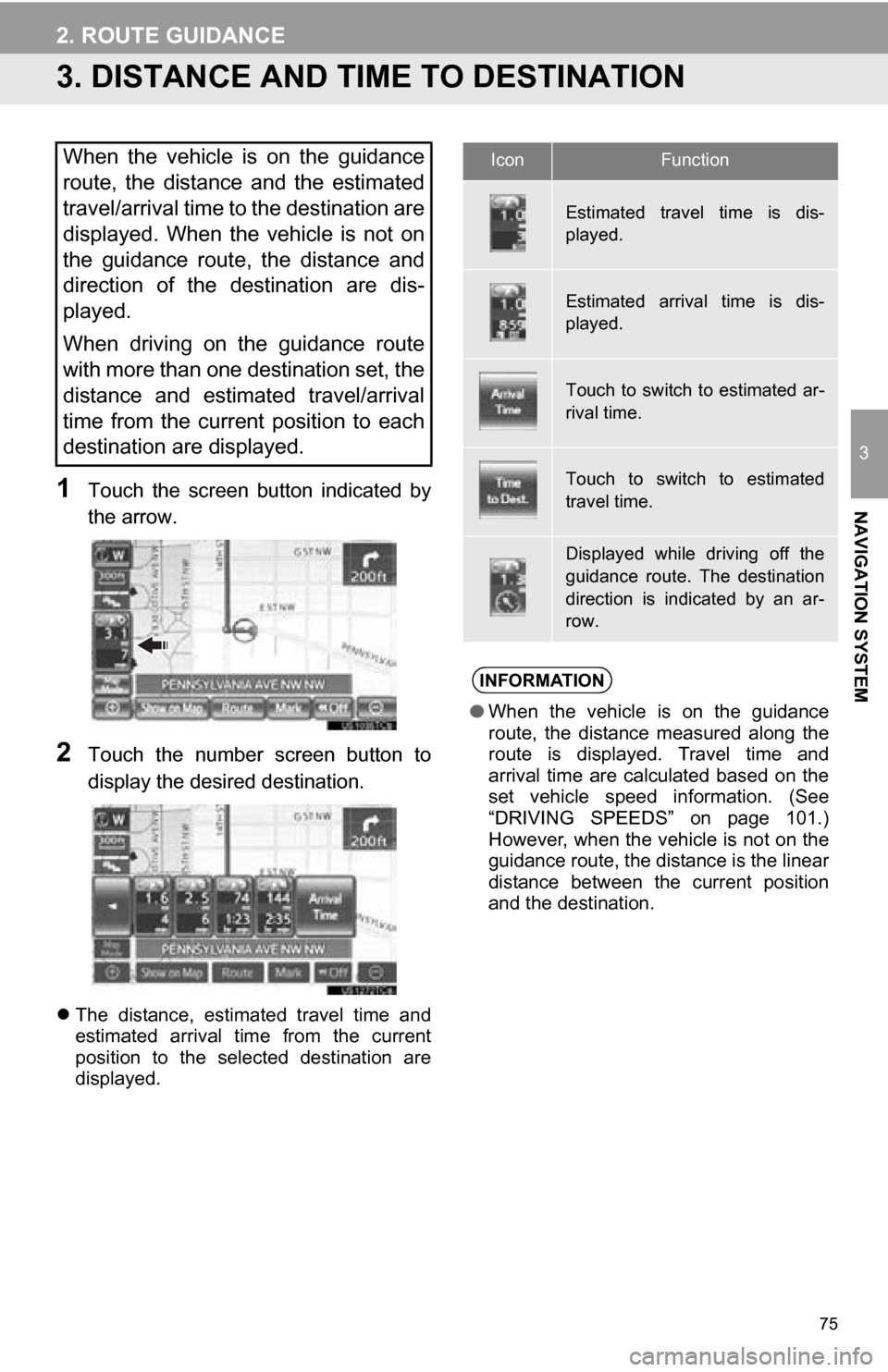
1Touch the screen button indicated by
the arrow.
2Touch the number screen button to
display the desired destination.
The distance, estimated travel time and
estimated arrival time from the current
position to the selected destination are
displayed.
When the vehicle is on the guidance
route, the distance and the estimated
travel/arrival time to the destination are
displayed. When the vehicle is not on
the guidance route, the distance and
direction of the destination are dis-
played.
When driving on the guidance route
with more than one destination set, the
distance and estimated travel/arrival
time from the current position to each
destination are displayed.IconFunction
Estimated travel time is dis-
played.
Estimated arrival time is dis-
played.
Touch to switch to estimated ar-
rival time.
Touch to switch to estimated
travel time.
Displayed while driving off the
guidance route. The destination
direction is indicated by an ar-
row.
INFORMATION
●When the vehicle is on the guidance
route, the distance measured along the
route is displayed. Travel time and
arrival time are calculated based on the
set vehicle speed information. (See
“DRIVING SPEEDS” on page 101.)
However, when the vehicle is not on the
guidance route, the distance is the linear
distance between the current position
and the destination.
Page 77 of 328
77
2. ROUTE GUIDANCE
3
NAVIGATION SYSTEM
1Touch “Route” .
2Touch “Delete” .
When more than one destination is set, a
list will be displayed on the screen.
3Touch the destination to be deleted.
“Delete All”: Touch to delete all destina-
tions on the list.
A message appears to confirm the request
to delete.
4Touch “Yes” to delete the destina-
tion(s).
If “Yes” is touched, the data cannot be
recovered. If more than 1 destination has
been set, the system will recalculate the
route(s) to the set destination(s) as neces-
sary.
If “No” is touched, the previous screen
will be displayed.
DELETING DESTINATIONS
A set destination can be deleted.
Page 78 of 328

78
2. ROUTE GUIDANCE
5. SETTING ROUTE
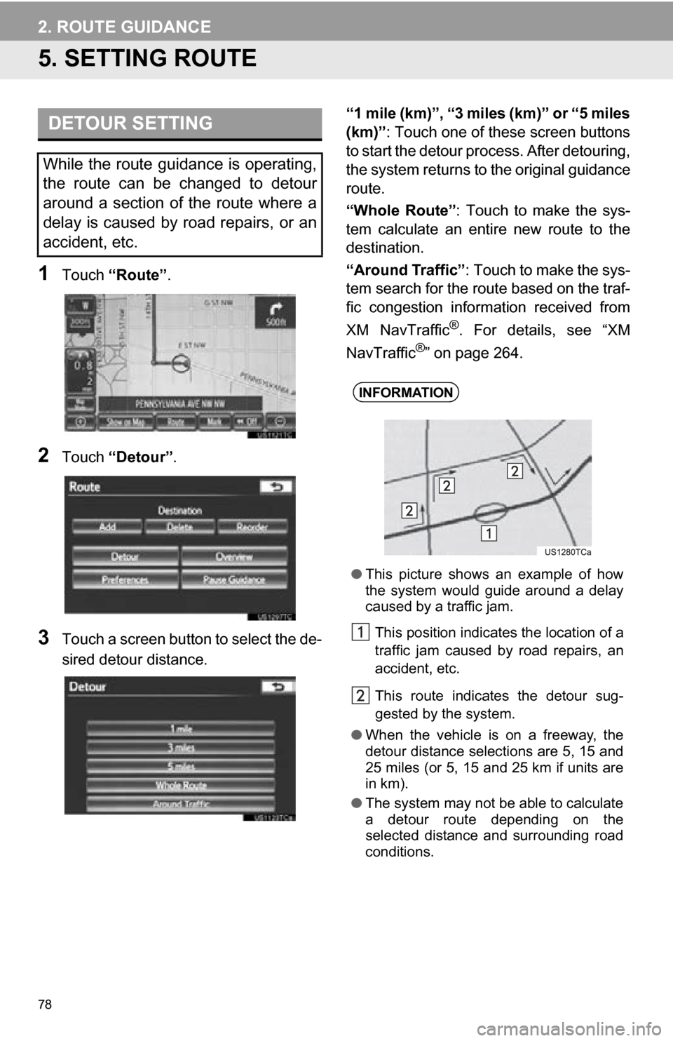
1Touch “Route” .
2Touch “Detour” .
3Touch a screen button to select the de-
sired detour distance. “1 mile (km)”, “3 miles (km)” or “5 miles
(km)”: Touch one of these screen buttons
to start the detour process. After detouring,
the system returns to
the original guidance
route.
“Whole Route” : Touch to make the sys-
tem calculate an entire new route to the
destination.
“Around Traffic” : Touch to make the sys-
tem search for the route based on the traf-
fic congestion information received from
XM NavTraffic
®. For details, see “XM
NavTraffic®” on page 264.
DETOUR SETTING
While the route guidance is operating,
the route can be changed to detour
around a section of the route where a
delay is caused by road repairs, or an
accident, etc.
INFORMATION
● This picture shows an example of how
the system would guide around a delay
caused by a traffic jam.
This position indicates the location of a
traffic jam caused by road repairs, an
accident, etc.
This route indicates the detour sug-
gested by the system.
● When the vehicle is on a freeway, the
detour distance selections are 5, 15 and
25 miles (or 5, 15 and 25 km if units are
in km).
● The system may not be able to calculate
a detour route depending on the
selected distance and surrounding road
conditions.
Page 79 of 328
79
2. ROUTE GUIDANCE
3
NAVIGATION SYSTEM
1Touch “Route” .
2Touch “Overview” .
3The entire route from the current posi-
tion to the destination is displayed.
1Touch or to skip to the next page
of the list of roads. Touch and hold
or to scroll through the list of roads.
: This mark indicates the direction in
which you should turn at the intersection.
“Map”: The selected point is displayed on
the map screen.
ROUTE OVERVIEW
Screen buttonFunction
“OK”Touch to start guidance.
“Turn List”
Touch to display a list of
the turns required to reach
the destination.
TURN LIST
INFORMATION
● However, not all road names in the route
may appear on the list. If a road
changes its name without requiring a
turn (such as on a street that runs
through 2 or more cities), the name
change will not appear on the list. The
street names will be displayed in order
from the starting point, along with the
distance to the next turn.
Page 81 of 328
81
2. ROUTE GUIDANCE
3
NAVIGATION SYSTEM
3Select the desired route preference.
The system will avoid using routes that
include items whose indicators are off.
4After selecting the desired route prefer-
ence, touch “OK”.
1Touch “Route” .
2Touch “Preferences” .
3Touch “Start from Adjacent Road” .
1Touch “Route” .
2Touch “Pause Guidance” .
The screen will return to the current posi-
tion map without route guidance.
STARTING ROUTE FROM
ADJACENT ROAD
The route guidance can be started
from an adjacent road.
(e.g. When route guidance is set on the
freeway, but the vehicle is driven paral-
lel along the freeway.)
INFORMATION
● When there is no adjacent road, this
screen button will not be displayed.
PAUSING AND RESUMING
GUIDANCE
TO PAUSE GUIDANCE
INFORMATION
●Without route guidance, “Pause Guid-
ance” cannot be used.
Page 83 of 328

83
2. ROUTE GUIDANCE
3
NAVIGATION SYSTEM
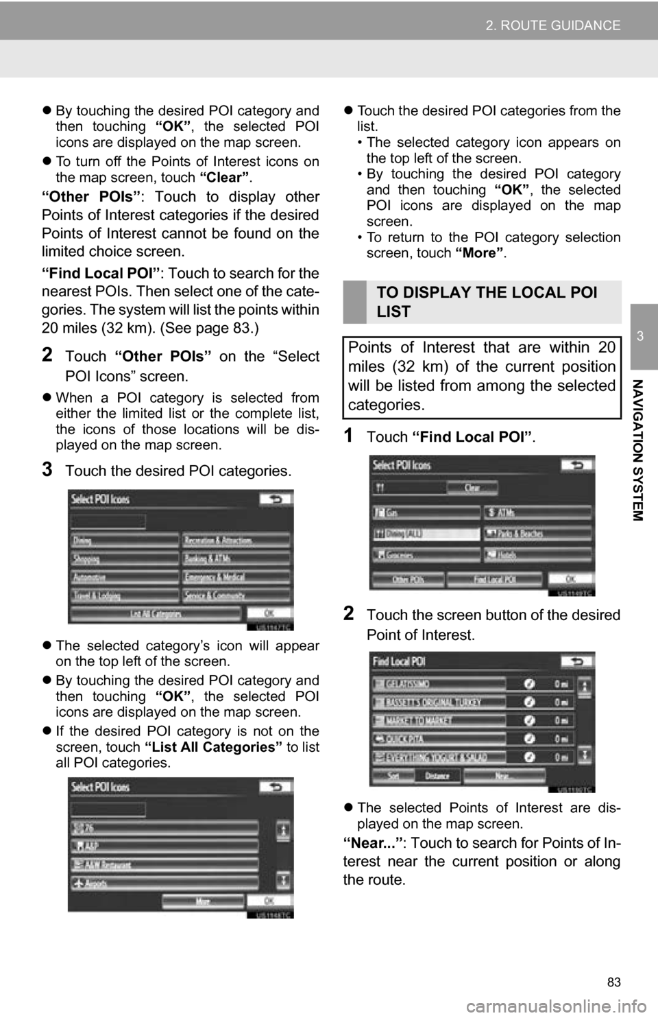
By touching the desired POI category and
then touching “OK”, the selected POI
icons are displayed on the map screen.
To turn off the Points of Interest icons on
the map screen, touch “Clear”.
“Other POIs”: Touch to display other
Points of Interest categories if the desired
Points of Interest cannot be found on the
limited choice screen.
“Find Local POI” : Touch to search for the
nearest POIs. Then select one of the cate-
gories. The system will list the points within
20 miles (32 km). (See page 83.)
2Touch “Other POIs” on the “Select
POI Icons” screen.
When a POI category is selected from
either the limited list or the complete list,
the icons of those locations will be dis-
played on the map screen.
3Touch the desired POI categories.
The selected category’s icon will appear
on the top left of the screen.
By touching the desired POI category and
then touching “OK”, the selected POI
icons are displayed on the map screen.
If the desired POI category is not on the
screen, touch “List All Categories” to list
all POI categories.
Touch the desired POI categories from the
list.
• The selected category icon appears on
the top left of the screen.
• By touching the desired POI category
and then touching “OK”, the selected
POI icons are displayed on the map
screen.
• To return to the POI category selection screen, touch “More”.
1Touch “Find Local POI” .
2Touch the screen button of the desired
Point of Interest.
The selected Points of Interest are dis-
played on the map screen.
“Near...” : Touch to search for Points of In-
terest near the current position or along
the route.
TO DISPLAY THE LOCAL POI
LIST
Points of Interest that are within 20
miles (32 km) of the current position
will be listed from among the selected
categories.
Page 85 of 328
85
2. ROUTE GUIDANCE
3
NAVIGATION SYSTEM1Touch “Show on Map” .
2Touch “Route Trace” .
The “Route Trace” indicator is highlighted.
1Touch “Show on Map” .
2Touch “Route Trace” .
Touching “Yes” stops recording and the
route trace remains displayed on the
screen.
Touching “No” stops recording and the
route trace is erased.
ROUTE TRACE
Up to 124 miles (200 km) of the trav-
eled route can be stored and retraced
on the display.
INFORMATION
● This feature is available when the map
scale is more than 30 miles (50 km).
TO START RECORDING THE
ROUTE TRACE
TO STOP RECORDING THE
ROUTE TRACE