Page 129 of 183

System Initialization
Navigation System129
GPS Initialization
Depending on the length of time the
battery was disconnected, your system
may require GPS initialization. If it
does, the following screen appears:
If this procedure is not necessary,
the system proceeds directly to the
Disclaimer screen (see page 18 ).
During initialization, the system
searches for all available GPS satellites
and obtains their orbital information.
During this procedure, the vehicle
should be out in the open with a clear
view of the sky. If the navigation system fi
nds the
satellites properly, this box clears and
the Disclaimer screen is shown. If
within 10 minutes the system fails to
locate a suffi cient number of satellites
to locate your position, the following
screen appears:
If the system is still unable to acquire
a signal, follow the instructions on
the screen, or contact your local
dealer for assistance.
NOTE:
The average acquiring time is less than
10 minutes.
Map Matching
This part of the initialization matches
the GPS coordinates found above with a
road on the map screen. To perform this
part of the procedure, ensure that the
navigation system is displaying a map,
and drive the vehicle on a mapped road
(a road shown on the map screen). Do
not enter a destination at this time.
When the name of the current road you
are driving on appears at the bottom
of the screen, the entire procedure is
complete. Your system is now ready
to use.
2013 TL
Page 130 of 183
System Initialization
130 Navigation System
Although your navigation system is one
of the most highly sophisticated pieces
of equipment you will fi nd in a modern
automobile, you may fi nd during its use
that it has certain limitations.
The system uses GPS signals to aid
in determining its current location.
The GPS is operated by the U.S.
Department of Defense. For security
reasons, there are certain inaccuracies
built into the GPS that the navigation
system must constantly compensate for.
This can cause occasional positioning
errors of up to several hundred feet.
For example, in urban areas where
streets are close together, this could
cause the system to show that you are
traveling on a street that parallels the
street you are actually on. The system
will, under most circumstances, correct
itself while you drive.
2013 TL
Page 131 of 183

System Limitations
Navigation System131
Also, depending on your current view
of the sky and the position of the
satellites, the elevation may be shown
incorrectly.
You may also notice some delay of the
vehicle position icon at intersections;
this is normal.
GPS Reception Issues
The signals received from the GPS
satellites are extremely weak (less
than a millionth of the strength of
a local FM station) and require an
unobstructed view of sky. The signal
can easily be interrupted or interfered
with by the following:
• Aftermarket metallic window tint
above or to the sides of the GPS
antenna (located on the back of the
navigation display)
• Cell phones, PDAs, or other electronic devices docked in a cradle
or lying loose on the dashboard
• Remote starters or “hidden” vehicle tracking systems mounted near the
navigation unit • Other aftermarket audio electronic
devices mounted near the navigation
unit
• Trees, tall buildings, freeway overpasses, tunnels, or overhead
electrical power wires
Although the system will direct you
to your desired destination, it may not
always generate what you consider to
be the most direct route. Try changing
the method of routing. See Changing
the Routing Method on page 53 . You may
also have Unver ifi ed Area Routing set
to OFF. See Unverifi ed Area Routing on
page 10 6 .
Additionally, the mapping database
contains verifi ed and unverifi ed maps.
See Map Overview on page 6 . A
Disclaimer screen will warn you if
your route includes unverifi ed streets.
Unver ifi ed streets may be missing from
the map, in the wrong location, or have
an incorrect name or address range.
Exercise additional caution when
driving in these unverifi ed areas. The destination icon shows the
approximate location of the destination.
This occurs because a city block can
have as many as 100 possible addresses
(for example, the 1400 block is followed
by the 1500 block) Since most cities
use only a portion of the 100 possible
addresses (for example, in the 1400
block, the addresses may only go up to
1425 before the 1500 block starts), the
address 1425 will be shown a quarter of
the way down the block by the system
instead of at the end of the block where
the destination is actually located.
You may fi nd that the system
occasionally reboots. This is
indicated by the display returning to
the globe screen. A reboot can be
caused by a number of things, such
as extreme temperatures or shock
from bumpy roads. It does not
necessarily indicate a problem that
requires service. If this happens
frequently, please see your dealer.
System Limitations
2013 TL
Page 132 of 183
 may be missing when you
search the database. This can be caused
if at the time the database was gather")
Database Limitations
132 Navigation System
You will fi nd that some points of
interest (POI) may be missing when you
search the database. This can be caused
if at the time the database was gathered,
the name was misspelled, the place
was improperly categorized, or the POI
change is not yet in the database. This
means you may not fi nd places listed
that you know exist. This is also true
for police agencies and hospitals. In
outlying areas, facilities listed may not
be the closest. Always check with local
information sources if you need law
enforcement or hospital services.
Every effort has been made to verify
that the system’s database was accurate
at the time it was created. However,
businesses do close or relocate, and new
businesses start in the old locations.
For this reason, you may occasionally
fi nd inaccurate information when you
select and drive to a point of interest
(for example, a restaurant is now a
jewelry store). The number of these
inaccuracies increases the longer you go
without an update. The digitized map database refl
ects
conditions as they existed at various
points in time before production.
Accordingly, your database may contain
inaccurate or incomplete data or
information due to the passage of time,
road construction, changing conditions,
or other causes.
Due to ongoing software and database
improvements, navigation software and
mapping versions versions may change
in the middle of a production year. The
version shipped with your vehicle was
the most recent available at the time of
production and is considered standard
equipment for that vehicle. There is no
free program to retrofi t early production
vehicles with the latest software and
mapping versions. For update DVD
ordering information, see page 135 . In addition, this database does not
include, analyze, process, consider, or
refl
ect any of the following categories
of information:
• Neighborhood quality or safety
• Population density
• Availability or proximity of law enforcement
• Emergency, rescue, medical, or other assistance
• Construction work, zones, or hazards
• Road and lane closures
• Legal restrictions (such as vehicular type, weight, load, height, and speed
restrictions)
• Road slope or grade
• Bridge height, w idth, weight, or other limits
2013 TL
Page 133 of 183
Database Limitations
Navigation System133
• Traffi c facilities safety
• Special events
• Pavement characteristics or conditions
We assume no liability for any incident
that may result from an error in the
program, or from changed conditions
not noted above. Copyrights
• Copyright © 2012 Zagat Survey,
LLC. All rights reserved.
• © 2012 NAVTEQ All Rights Reserved.
• Portions of the software in this product are copyright 2007 The
FreeType Project ( www.freetype.org).
All rights reserved.
Licensed under the FreeType Project LICENSE, 2006-Jan-27. ( http://www.
freetype.org/FTL.TXT )
2013 TL
Page 134 of 183

Client Assistance
134 Navigation System
Reporting Errors
Occasionally, you may encounter
database errors.
• If the error pertains to freeways and
main “verifi ed” roads shown in black
on the map, then report it online at
http://update.navteq.com / .
• If the error involves a purple “unverifi ed” road, then do not report
it. These areas have not been verifi ed
and are provided for reference only
(see Map Overview on page 6 ).
• For errors in points of interest (POI), like a business that has changed its
name, do not report them. Keep in
mind that depending on when the
data was collected, the database can
be out of date. The business may
have not reported the change(s), or
not be in the database at all. Update
Navigation DVDs are available for
purchase, usually in the fall of each
year. See Obtaining a Navigation
Update DVD on page 135 regarding
updates to the navigation system. • If the error does not involve the
database, such as vehicle position
icon error, screen error messages,
or other GPS related errors, see
Frequently Asked Questions o n
page 155 , System Limitations GPS
Reception IssuesPS Reception Issues
on page 131 , or Tr o u b l e s h o o t i n g on
page 163 . Acura Client Relations
T
elephone: (800) 382-2238
Fa x: (310) 783-3535
Mail:
Acura Navi
America Honda Motor Co., Inc.
Acura Client Relations
MS 500-2N-7E
1919 Tor r a nce Blvd.
Torrance, CA 90501-2746
2013 TL
Page 135 of 183

Client Assistance
Navigation System135
Visiting Your Dealer
We strive to make this manual as
complete as possible and to answer all
questions regarding operation of the
system. Occasionally, you may run into
a specifi c issue that you cannot fi nd
in the book. You may save yourself a
trip to the dealer by fi rst consulting the
following resources:
• The Troubleshooting section (see page 163 )
• The Frequently Asked Questions (FAQs) section (see page 155 )
• The FAQs found on the online update DVD order site (see “Obtaining a
Navigation Update DVD”)
• For detailed questions regarding HFL, audio, or other systems that
interact with the navigation system,
see your owner’s manual, or the
Advanced Technology Guide.
• For traffi c-related issues, see the
“ AcuraLink Real-Time Traffi c™ ”
section (on page 23 ) and FAQs (on
page 155 ). • Call Acura Client Relations (see
Acura Client Relations on page 134 ).
• For database or POI issues, follow the guidelines in the “ Reporting Errors ”
section (see page 134 ).
If your question is still unanswered
and you wish to visit the dealer, please
be prepared to demonstrate the issue
to the service consultant. That way,
the service consultant can document
the issue for the factory to allow more
effi cient troubleshooting.
Some issues may at fi rst seem random,
but you may notice a pattern, like they
only occur when you enter a specifi c
address, when driving on a certain road,
or just when it’s cold. This information
is very useful to the service consultant.
Be patient, the service consultant may
be unfamiliar with your specifi c issue. Obtaining a Navigation
Update DVD
Acura is continually expanding the
scope of the navigation system.
Upgraded software may be made
available to navigation system
owners periodically, usually in the
fall of each year.
To purchase an updated DVD, you will
need your vehicle’s VIN number and the
System/Device Information from the
INFO screen (Other). Call the Acura
Navigation Disc Fulfi
llment Center at
(888) 549-3798, or order online by going
to www.acuranavi.com.
NOTE:
• Update DVDs are not available at your dealer. However, the dealer may
order an update DVD for you out of
courtesy. There is no program for
free DVD updates.
• The update DVD order line staff cannot answer technical questions
regarding navigation operation,
coverage, or POIs.
2013 TL
Page 136 of 183

Coverage Areas
136 Navigation System
Map Coverage
The system provides map coverage for
the following U.S. states, as well as for
Canada, Puerto Rico, and Mexico. The
map coverage consists of accurately
mapped (verifi ed) metropolitan areas
(in the following list) and a less
accurate (unverifi ed) rural database.
See Map Overview on page 6 for a
discussion of map coverage.
The cities and metropolitan areas in the
following list are fully mapped. Only
major streets, roads, and freeways have
been verifi ed outside these areas. If
your route passes through these areas,
routing may be limited, depending on
your routing choices. See Unverifi ed
Area Routing on page 106 .
If you desire additional map coverage
information, contact Acura Client
Relations or go to www.acuranavi.com .
Enter your vehicle model and model
year, and then select the state for which
you want to verify map coverage.
U.S. Detailed Coverage Areas
Alabama
Auburn-Opelika
Bir m ingham / Tuscaloosa
Huntsville
Mobile
Montgomery
Alaska Anchorage
Fairban ks-Denali
Juneau
Arizona Phoenix Metro
Prescott
Sedona
Tu c s o n
Yu m a
Arkansas Fayetteville
Fort Smith
Hot Springs
Little Rock
Pine Bluff
California Central Valley - including Fresno, Merced, Modesto, and Stockton
Humboldt
Los Angeles/San Diego Metro Redding
Mammoth Lakes
Sacramento Metro
San Francisco Bay
(approximately
Monterey to Sonoma) – including
Monterey County and Hollister
Southern California Area – including
Bakersfi eld and San Luis Obispo
Yu b a
Colorado Denver/Boulder/Colorado Springs/Ski Resorts Metro area – including
Ft. Collins
Durango
Grand Junction
Te l l u r i d e
Connecticut Bridgeport
Danbury
Hartford Metro
New Haven Metro
Norwalk
Stamford
Delaware Entire state – including Dover, Wilmington Metro area, New
Castle County
2013 TL
 1
1 2
2 3
3 4
4 5
5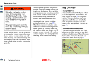 6
6 7
7 8
8 9
9 10
10 11
11 12
12 13
13 14
14 15
15 16
16 17
17 18
18 19
19 20
20 21
21 22
22 23
23 24
24 25
25 26
26 27
27 28
28 29
29 30
30 31
31 32
32 33
33 34
34 35
35 36
36 37
37 38
38 39
39 40
40 41
41 42
42 43
43 44
44 45
45 46
46 47
47 48
48 49
49 50
50 51
51 52
52 53
53 54
54 55
55 56
56 57
57 58
58 59
59 60
60 61
61 62
62 63
63 64
64 65
65 66
66 67
67 68
68 69
69 70
70 71
71 72
72 73
73 74
74 75
75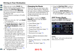 76
76 77
77 78
78 79
79 80
80 81
81 82
82 83
83 84
84 85
85 86
86 87
87 88
88 89
89 90
90 91
91 92
92 93
93 94
94 95
95 96
96 97
97 98
98 99
99 100
100 101
101 102
102 103
103 104
104 105
105 106
106 107
107 108
108 109
109 110
110 111
111 112
112 113
113 114
114 115
115 116
116 117
117 118
118 119
119 120
120 121
121 122
122 123
123 124
124 125
125 126
126 127
127 128
128 129
129 130
130 131
131 132
132 133
133 134
134 135
135 136
136 137
137 138
138 139
139 140
140 141
141 142
142 143
143 144
144 145
145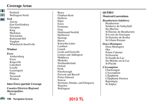 146
146 147
147 148
148 149
149 150
150 151
151 152
152 153
153 154
154 155
155 156
156 157
157 158
158 159
159 160
160 161
161 162
162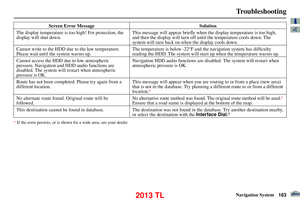 163
163 164
164 165
165 166
166 167
167 168
168 169
169 170
170 171
171 172
172 173
173 174
174 175
175 176
176 177
177 178
178 179
179 180
180 181
181 182
182
