2012 Seat Exeo navigation system
[x] Cancel search: navigation systemPage 134 of 167

Navigation (NAV)*133
Operating
RADIO, MEDIA (audiovisual
systems)
NAME, TEL
NAV, INFO
CAR, SETUP
On
The map display will change automatically according to the set map scale. If
the scale is less than 2.5 km, the map is oriented to vehicle. When the scale
is greater than 2.5 km, the display is oriented to North.
Map type
You can choose from four different map types.– Press the
⇒page 9 function button in the navigation
menu.
– Select the desired map display under Map type ⇒ page 131,
fig. 160 .The map types "destination", "location" or "overview" are 2-dimensional. If
you select "Location 3D" the map is shown in three dimensions.
The following settings are possible: Destination
The map display is oriented to the destination, meaning that the map always
shows the current single destination or final destination for a current route
plan. The destination is marked with a destination flag. When you select this
map type, the
North ⇒ page 132 orientation is set automatically to make it
easier to orient yourself.
Location map
The current vehicle location is displayed. The orientation of the map matches
the settings in the Navigation System ⇒page 132.
Overview
When you select this type of map, the entire remaining route is shown auto-
matically in the base scale ⇒fig. 164 . To make the map display easier to
read, it is automatically oriented to North ⇒ page 132.
Current position 3D
The map is shown in a 3D perspective (as seen from the current location).
When you select this map type, the map display will automatically switch to
the setting dir. of travel ⇒ page 132 to provide a better overview.
Fig. 164 Navigation
Setup: Map type overview
SETUP
media_systemE_EN.book Seite 133 Montag, 21. September 2009 1:48 13
Page 135 of 167

Navigation (NAV)*
134Spoken navigation directions– Press the ⇒page 9 function button in the navigation
menu.
– Select the desired setting under Voice g uida nce ⇒ fig. 165 .•Set to on : You will receive spoken navigation directions during route guid-
ance.•Set to off : You will NOT receive any spoken navigation directions during
route guidance.•Set to off (tel.) : You will hear spoken navigation directions during route
guidance, but NOT while you are on the phone.
Map content
In addition to the information displayed automatically, the
map can also display other information.Activating the map contents
–Press the ⇒ page 9 function button in the navigation
menu.
– Select Map contents ⇒ page 131, fig. 160 .
– Use the rotary pushbutton to select the information you want to have displayed. A tick
will appear next to the options that are
selected ⇒ fig. 166, or
– Select the All categories option and press the control knob so
that a check mark
appears after All categories. The tick box
will also appear after all the options.
Deactivating individual map contents
–Press the ⇒ page 9 function button in the navigation
menu.
Fig. 165 Navigation
settings: Voice informa-
tion
SETUP
Fig. 166 Navigation
settings: Map contents
list
SETUPSETUP
media_systemE_EN.book Seite 134 Montag, 21. September 2009 1:48 13
Page 136 of 167

Navigation (NAV)*135
Operating
RADIO, MEDIA (audiovisual
systems)
NAME, TEL
NAV, INFO
CAR, SETUP
–Select Map contents ⇒ page 131, fig. 160 .
– Use the rotary pushbutton to remove the tick
if you do not want
to have the information shown on the map.
Deactivating all map contents
– Press the ⇒page 9 function button in the navigation
menu.
–Select Map contents ⇒ page 131, fig. 160 .
– First select the All filters option and press the control knob so
that the tick box appears after it
. The tick box
will also
appear after all the options.
– Then press the control knob again and the check marks
after
all the options will disappear.
In addition to the information displayed automatically, the map can also
display other information.
You can select the map contents to be displayed as desired. The map
contents are displayed in accordance with the selected map scale.Delete last destinations– Press the ⇒page 9 function button in the navigation
menu.
–Select Delete last destinations ⇒ page 131, fig. 160 .
–Confirm Are you sure you want to delete the route? with Ye s. The
entire list of last destinations is deleted ⇒page 116.
Turn l ist
During the route guidance a list of upcoming turns (including
distance) is displayed.–Press the ⇒page 9 function button in the navigation
menu.
– Place a tick
⇒ page 131, fig. 161 next to the option Tu r n l ist to
activate the option.
The turn list displays the next three upcoming turns ⇒ fig. 167.
The next upcoming turn is listed at the lowest position in the list.
Once you have completed the manoeuvre, it will be removed from the list. The
next turn will drop down from above, etc.
The following information is displayed in the turn list:•Recommended turning direction, roundabouts and slip roads, stopovers
and final destination•Names of all roads on to which you should turn•Distance to the corresponding manoeuvre and final destination
SETUPSETUP
Fig. 167 Navigation
settings: Map display
with turn list activated
SETUP
A1
media_systemE_EN.book Seite 135 Montag, 21. September 2009 1:48 13
Page 137 of 167
Navigation (NAV)*
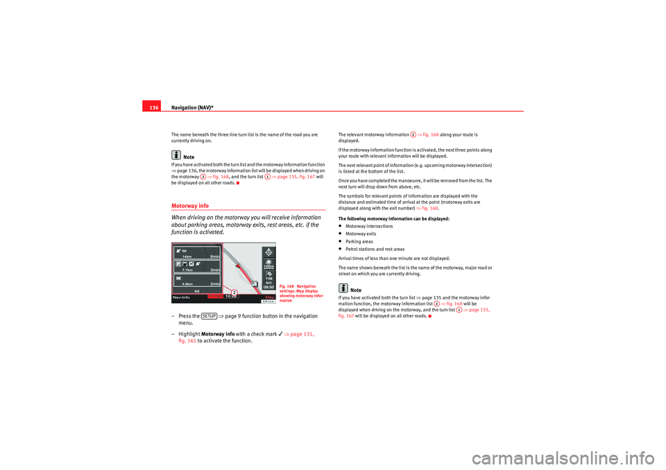
136The name beneath the three-line turn list is the name of the road you are
currently driving on.
Note
If you have activated both the turn list and the motorway information function
⇒ page 136, the motorway information list will be displayed when driving on
the motorway ⇒ fig. 168, and the turn list ⇒ page 135, fig. 167 will
be displayed on all other roads.Motorway info
When driving on the motorway you will receive information
about parking areas, motorway exits, rest areas, etc. if the
function is activated.– Press the ⇒page 9 function button in the navigation
menu.
– Highlight Motorway info with a check mark
⇒ page 131,
fig. 161 to activate the function.
The relevant motorway information ⇒fig. 168 along your route is
displayed.
If the motorway information function is activated, the next three points along
your route with relevant information will be displayed.
The next relevant point of information (e.g. upcoming motorway intersection)
is listed at the bottom of the list.
Once you have completed the manoeuvre, it will be removed from the list. The
next turn will drop down from above, etc.
The symbols for relevant points of information are displayed with the
distance and estimated time of arrival at the point (motorway exits are
displayed along with the exit number) ⇒fig. 168 .
The following motorway information can be displayed:•Motorway intersections•Motorway exits•Parking areas•Petrol stations and rest areas
Arrival times of less than one minute are not displayed.
The name shown beneath the list is the name of the motorway, major road or
street on which you are currently driving.Note
If you have activated both the turn list ⇒page 135 and the motorway infor-
mation function, the motorway information list ⇒fig. 168 will be
displayed when driving on the motorway, and the turn list ⇒page 135,
fig. 167 will be displayed on all other roads.
A2
A1
Fig. 168 Navigation
settings: Map display
showing motorway infor-
mation
SETUP
A2
A2
A1
media_systemE_EN.book Seite 136 Montag, 21. September 2009 1:48 13
Page 138 of 167
Navigation (NAV)*137
Operating
RADIO, MEDIA (audiovisual
systems)
NAME, TEL
NAV, INFO
CAR, SETUP
Intersection map– Press the ⇒page 9 function button in the navigation
menu.
– Highlight the Intersection map with a check mark
⇒ fig. 169
to activate the function.
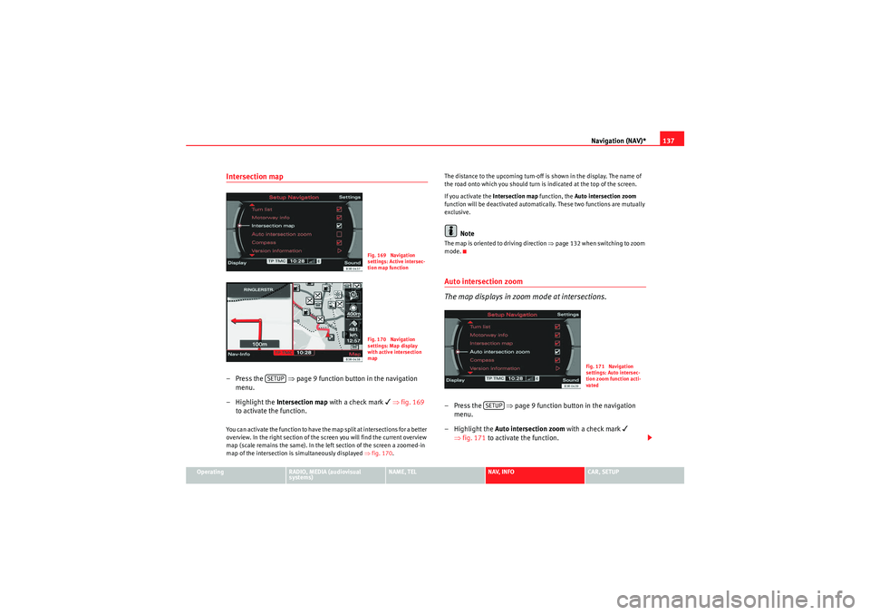
You can activate the function to have the map split at intersections for a better
overview. In the right section of the screen you will find the current overview
map (scale remains the same). In the left section of the screen a zoomed-in
map of the intersection is simultaneously displayed ⇒fig. 170 . The distance to the upcoming turn-off is shown in the display. The name of
the road onto which you should turn is indicated at the top of the screen.
If you activate the
Intersection map function, the Auto intersection zoom
function will be deactivated automatically. These two functions are mutually
exclusive.
Note
The map is oriented to driving direction ⇒page 132 when switching to zoom
mode.Auto intersection zoom
The map displays in zoom mode at intersections.–Press the ⇒page 9 function button in the navigation
menu.
– Highlight the Auto intersection zoom with a check mark
⇒ fig. 171 to activate the function.
Fig. 169 Navigation
settings: Active intersec-
tion map functionFig. 170 Navigation
settings: Map display
with active intersection
map
SETUP
Fig. 171 Navigation
settings: Auto intersec-
tion zoom function acti-
vated
SETUP
media_systemE_EN.book Seite 137 Montag, 21. September 2009 1:48 13
Page 139 of 167
Navigation (NAV)*
138If you have activated the Auto intersection zoom and have set the
Destination , Location or Location 3D map type ⇒page 133, the map will
automatically zoom in at intersections. This provides a better view of the road
layout.
If you activate the Auto intersection zoom function, the Intersection map
function will be deactivated automatically. These two functions are mutually
exclusive.Co mp ass
–Press the ⇒ page 9 function button in the navigation
menu.
– Highlight Compass with a check mark
⇒ fig. 172 to activate
the function.
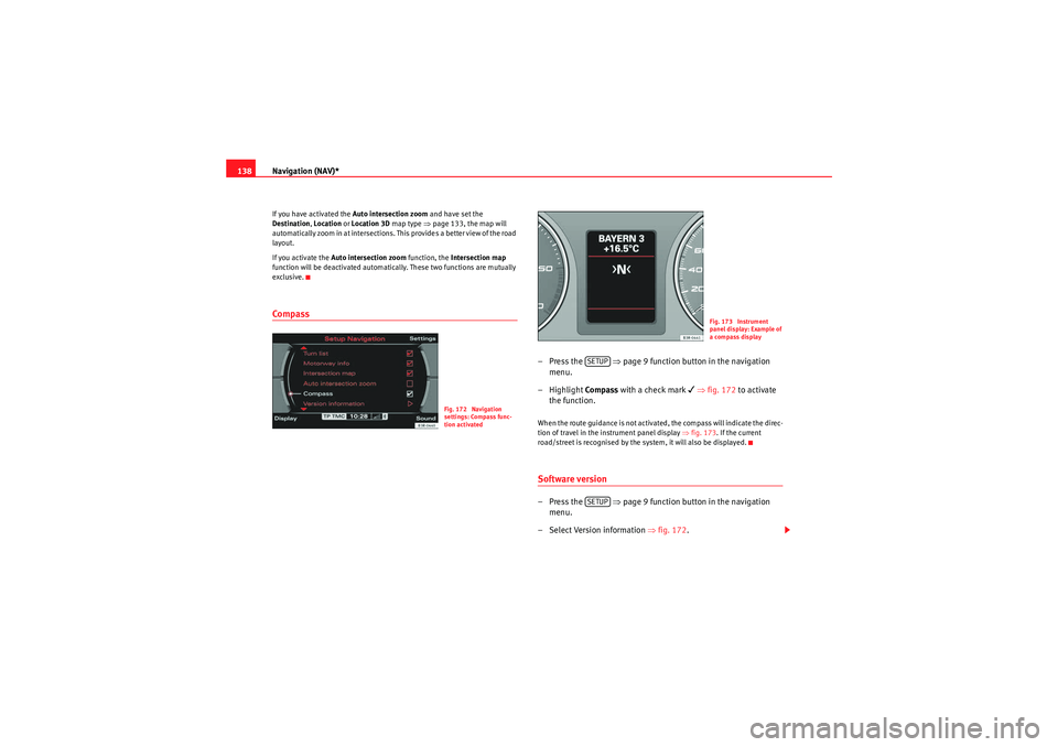
When the route guidance is not activated, the compass will indicate the direc-
tion of travel in the instrument panel display ⇒fig. 173. If the current
road/street is recognised by the system, it will also be displayed.Software version–Press the ⇒ page 9 function button in the navigation
menu.
– Select Version information ⇒fig. 172 .
Fig. 172 Navigation
settings: Compass func-
tion activated
Fig. 173 Instrument
panel display: Example of
a compass display
SETUPSETUP
media_systemE_EN.book Seite 138 Montag, 21. September 2009 1:48 13
Page 140 of 167
Navigation (NAV)*139
Operating
RADIO, MEDIA (audiovisual
systems)
NAME, TEL
NAV, INFO
CAR, SETUP
The software version of the current navigation DVD will be displayed.
Note
You can obtain information on updates for the navigation DVD from your
Dealer.Demo mode– Press the
⇒page 9 function button in the navigation
menu.
– Place a tick
⇒ fig. 174 next to the option Demo mode to acti-
vate the option.
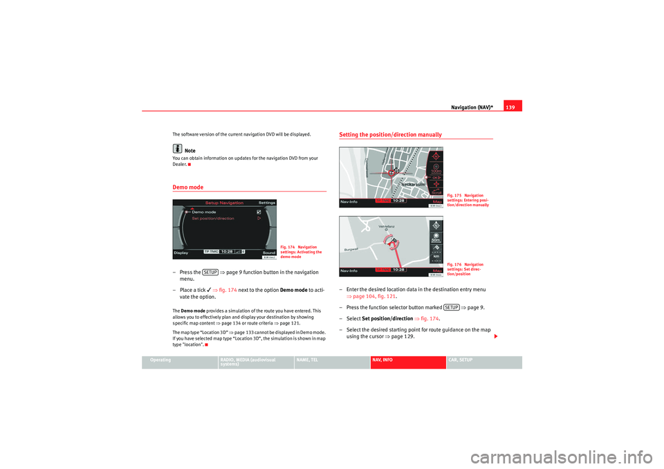
The Demo mode provides a simulation of the route you have entered. This
allows you to effectively plan and display your destination by showing
specific map content ⇒page 134 or route criteria ⇒page 121.
The map type “Location 3D” ⇒page 133 cannot be displayed in Demo mode.
If you have selected map type “Location 3D”, the simulation is shown in map
type "location".
Setting the position/direction manually– Enter the desired location data in the destination entry menu ⇒page 104, fig. 121 .
– Press the function selector button marked ⇒page 9.
– Select Set position/direction ⇒ fig. 174.
– Select the desired starting point for route guidance on the map using the cursor ⇒page 129.
Fig. 174 Navigation
settings: Activating the
demo mode
SETUP
Fig. 175 Navigation
settings: Entering posi-
tion/direction manuallyFig. 176 Navigation
settings: Set direc-
tion/positionSETUP
media_systemE_EN.book Seite 139 Montag, 21. September 2009 1:48 13
Page 141 of 167
Navigation (NAV)*
140
– Select OK in the active side menu ⇒ page 139, fig. 175.
– Set the direction of the location ⇒page 139, fig. 176 by rotating
the control knob.
– When you press the control knob, the system automatically jumps back to the navigation setup menu.You can calculate the route from anothe r position than the present vehicle
location.
We recommend entering the data for the starting point into a destination
entry menu ⇒page 104, fig. 121 before you select the Set
Position/Direction . That way the system will jump to the point entered on the
map display. It is easier to set the location on the map from this point.
You can use the cursor to search for the starting point ⇒page 129. You can
manually enter the starting location of the vehicle, for example to calculate
future navigation routes starting from a location other than the current loca-
tion of the vehicle. Once you have set a location on the map, you can switch
to the destination input menu to enter the information for the desired desti-
nation. Use the demo mode to simulate a route guidance ⇒page 139.
Note
For technical reasons, setting the start location manually and simulating
route guidance in demo mode is only possible when the vehicle is stationary
and there is no GPS reception ⇒page 98 (e.g. in an underground garage).
media_systemE_EN.book Seite 140 Montag, 21. September 2009 1:48 13