Page 47 of 313
 map ............................3-3
Building graphics ...........")
3 Map settings
Map types........................................3-2
2Dmap .......................................3-2
Birdview ™ (3D) map ............................3-3
Building graphics ...............................3-3
Displaying the current vehicle location ...............3-5
Operation with buttons on control panel ...........3-5
Operating with the touch operation ...............3-5
Moving a map . . . ..................................3-6
2Dmap .......................................3-6
Birdview™ (3D) map ............................3-7
Changing the scale of a map ........................3-9
Map scale . . . ..................................3-9
Changing the map view ........................... 3-11
Available views ................................ 3-12Other settings
................................. 3-13
Setting the map view .............................. 3-13
Basic operation ............................... 3-14
Setting the map orientation .....................3-15
Setting the long range map view ................3-17
Setting the map color .......................... 3-18
Changing the Birdview™ angle ..................3-19
Setting the left screen display ...................3-20
Looking at information on the map ..................3-21
Displaying map icons .......................... 3-21
Map scrolling information . . . ....................3-23
Map symbols .................................. 3-24
Road color .................................... 3-27
Traffic information on map ......................3-27
Page 48 of 313
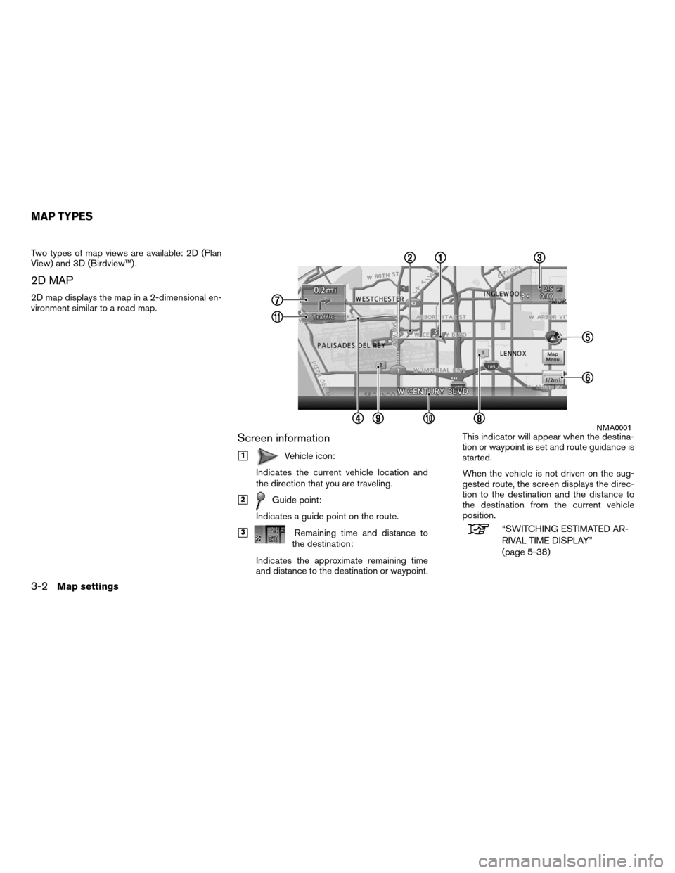
Two types of map views are available: 2D (Plan
View) and 3D (Birdview™) .
2D MAP
2D map displays the map in a 2-dimensional en-
vironment similar to a road map.
Screen information
�1Vehicle icon:
Indicates the current vehicle location and
the direction that you are traveling.
�2Guide point:
Indicates a guide point on the route.
�3Remaining time and distance to
the destination:
Indicates the approximate remaining time
and distance to the destination or waypoint. This indicator will appear when the destina-
tion or waypoint is set and route guidance is
started.
When the vehicle is not driven on the sug-
gested route, the screen displays the direc-
tion to the destination and the distance to
the destination from the current vehicle
position.“SWITCHING ESTIMATED AR-
RIVAL TIME DISPLAY”
(page 5-38)
NMA0001
MAP TYPES
3-2Map settings
Page 49 of 313

�4Suggested route:Appears in bold yellow during route
guidance.
�5/Direction indicator:
Indicates the setting of the map: north al-
ways pointing up or the vehicle’s direction
always pointing up on the display. Touch the
icon to change this setting.
“SETTING THE MAP ORIENTA-
TION” (page 3-15)
�6Scale indicator:
Indicates the scale of the map.
Touch the icon to display the scale bar. This
allows the map scale to be adjusted.
“OPERATING WITH THE
TOUCH OPERATION”
(page 3-5)
�7Arrow and distance:
Indicates the distance to the next guide
point and the turning direction at that guide
point.
�8Stored Location (orange) :
Displays the locations that are stored in the
Address Book. Icons can be changed ac-
cording to personal preferences.
�9Avoid Area (green or blue) :
Displays the areas to avoid that are stored
in the Address Book with green or blue
icons. During the route search, the route
guidance is performed by searching for a
route that avoids those areas.
�10Street name: Displays the name of the street the vehicle
is currently driving on.
�11Traffic indicator:Displays the reception condition of traffic
information transmitted from the provider.
Green: Reception condition is good.
Gray: Reception condition is not good.
No mark: Subscription to XM NavTraffic�
service is not detected.
Birdview ™ (3D) MAP
Birdview ™ displays the map from an elevated
perspective. In Birdview ™, it is easy to recognize
an image of the route because it provides a pan-
oramic view over a long distance.
INFO:
About the Birdview ™ display
● “Birdview ™” is a registered trademark of
Clarion Co., Ltd.
● The map in Birdview ™ always appears with
the current forward direction facing up.
BUILDING GRAPHICS
In the area where the building graphics are
stored in the map data, the building graphics are
displayed when the map is zoomed in. On the
2D map display, these are called “Building foot-
print graphics”, and on the Birdview™ display,
these are called “3D building graphics”.
The method to look at the map is the same for
the 2D and Birdview™ maps.
NMA0002
Map settings3-3
Page 51 of 313
OPERATION WITH BUTTONS ON
CONTROL PANEL
The basic map screen displays the current loca-
tion (the position where the vehicle mark is
located) . Press MAP to display the current loca-
tion on the map while on any screen.
INFO:
Depending on the menu selected, pressing MAP
may not return the display to the current location
map screen.
OPERATING WITH THE TOUCH
OPERATION
After moving the map, touch “Back” on the map
screen to display the current location map
screen.
NMA0005NMA0006
DISPLAYING THE CURRENT VEHICLE
LOCATION
Map settings3-5
Page 52 of 313
The operations for moving across the map are
different between the 2D and Birdview™ maps.
2D MAP
1. Touch the screen.Displays the cross pointer, and the touched
position is set as the center of the screen. 2. Touch and hold the direction to move to.
The map continues to scroll while the
screen is touched.
INFO:
While driving, scrolling on the map is limited to a
specified distance.
If the map screen is set to the building footprint
graphics, the map cannot be scrolled while
driving.
NMA0008NMA0009
MOVING A MAP
3-6Map settings
Page 53 of 313
Fine-adjusting the cursor position:1. Touch “Slow”. Displays the 8-directional key. 2. Touch the 8-directional key to adjust the
cross pointer position. Touch “Back” to end
the adjustment.
INFO:
Fine-adjusting the cursor position is not possible
while driving.
Birdview™ (3D) MAP
LNV2008NMA0011LNV0607
Map settings3-7
Page 54 of 313
1. Touch the screen.Displays the cross pointer and 8-directional
key. 2. Touch the direction to move to. The map
continues to scroll while the screen is
touched. 3. Touchorto change the di-
rection of the map.
Rotates the map clockwise.
Rotates the map counterclockwise.
INFO:
While driving, scrolling on the map is limited to a
specified distance.
LNV0572LNV0573LNV0574
3-8Map settings
Page 55 of 313

1. Touch “ZOOM IN” or “ZOOM OUT” tochange the scale.
Voice command
1. Press
button located on the steering
wheel switch.
2. After the tone sounds, speak a command. To change the map scale:
“Zoom In <1 to 13>” (Alternate command
mode)
“ALTERNATE COMMAND
MODE” (page 9-16)
“Zoom Out <1 to 13>” (Alternate com-
mand mode)
MAP SCALE
Any required map scale (map coverage) be-
tween 320 miles (640 km) and 1/32 of a mile
(50 m) can be selected. If a destination has been
set, one-touch operation can be used to switch
to a scale at which the complete route to the next
destination can be viewed.
Scale level for 2D map and Birdview™
map (3D) display
Normal Map English Units Metric Units
320 Miles 640 km80 miles 160 km
32 miles 64 km
8 miles 16 km
5 miles 10 km
2 miles 4 km
1 mile 2 km
1/2 mile 1 km
1/4 mile 500 m
1/8 mile 200 m
1/16 mile 100 m
1/32 mile 50 m
Shows building
footprint graph- ics 1/32 mile
50 m
1/64 mile 25 m
LNV0576
Example: The most detailed level (2D map)LNV0577
CHANGING THE SCALE OF A MAP
Map settings3-9
 . Press MAP to display the current loca-
tion on the map w")


