2012 MERCEDES-BENZ C-Class sat nav
[x] Cancel search: sat navPage 90 of 234

Route
guidanc efrom anoff-road
lo cati ontoad esti nation If
th eveh icle posit ioniswith inthearea
cov ered bythedigit almap, butthemap does
no tcon tain anyinform ationabout that
locat ion,th eveh icle isin an off-road locat ion.
COMA NDisalso able toguide youtoa
dest inationeven from anoff-road locat ion.
At thest art oftherout eguidan ce,you willsee
th eOff Mapped Road mes
sage, anarro w
and thedist anceto thed estin ation. Thearrow
shows thecompass headingtothe actual
destin ation.
The route ishighlighted blue,startingfrom
the last recogn izedstreet the vehicle wason
before itleft themap.
As soon asthe vehicle isback onaroad
kn own tothe system, routeguidance
con tinues inthe usual way.
Rout eguida ncefrom anoff-m ap
location toad esti nation If
th eveh icle posit ionisouts idethearea
cov ered bythedigit almap, then theveh icle
is in an off-map locat ion.COMAND isalso
able toguide youtoadestination evenfrom
an off-map location.
At the start ofthe route guidance,youwillsee
the Off Mapped Road message,
anarrow
and thedistance tothe destination. The
direction arrowshows thecompass heading
to the destination.
The route ishighlig htedbluefrom thenearest
road known tothe system.
As soon asthe vehicle isback onaroad
known tothe system, routeguidance
cont inues inthe usua lway .
Off-road duringrouteguidance Due
toroadworks, forexample, theremaybe
differences betweenthedata onthe digital
map andtheactual course ofthe road.
In such cases, thesystem willtemporarily be
unable tolocate thevehicle position onthe digital
mapandthus considers thevehicle to
be inan off-road position.
In the displa y,you willsee theOff Mapped Road message,
anarrow andthedistance to
the destination. Thedirection arrowshows
the compass headingtothe destination.
As soon asthe system canassign thevehicle
position tothe map again,route guidance
cont inues inthe usua lway . Tra
ffic reports Condition
s
To receive real-time trafficreports via
satellite radio,yourequire:
R optionally available satellite radio
equi pment
R asubscription toSIRIUS XMSatellite Radio
Traffic Message Service
Further information onsatellite radiois
avail able inthe "Satellite radio"section
(Y page 148).
COMAND canreceive trafficreports via
satellite radioandtake account ofthese for
route guidanceinthe navigation system.
Received trafficreports aredispla yedinthe
map either astext oras icons. Real-time
traffic report sin the map
COMAND canshow certain trafficincidents
on the map. Traffic reports areshown onthe
map atscales of0.05 mito20 mi.
X To hide themenu: slideZVtheCOMAND
cont roller and,when theFull Screen menu
itemisshown, pressWtoconfirm.
The map canbeseen inthe full-screen
displa y.
X Turn cVd theCOMAND controller untilthe
desired mapscale isset. 88
Tr
affic report sNavigat ion
Page 104 of 234

Map
information inthe display During
routeguidance, youcan have map
informati onshow natthe bottom edgeofthe
displa y.
Showing textinformat ion
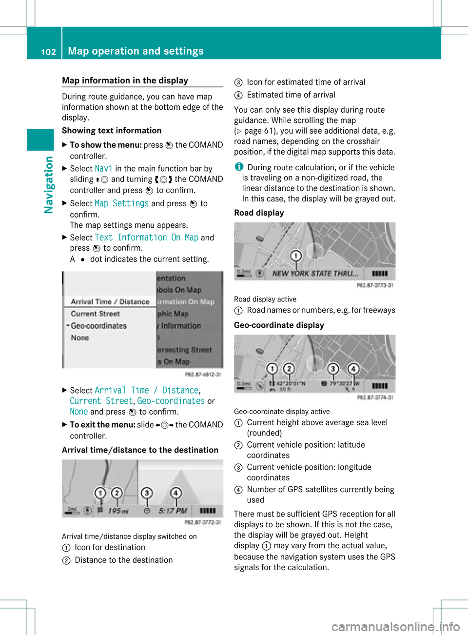
X To show themenu: pressWthe COMAND
cont roller.
X Select Navi in
the main functionbar by
sliding ZVandturning cVdtheCOMAND
cont roller andpress Wtoconfirm .
X Select MapSettings and
press Wto
confirm .
The map settin gsmenu appears.
X Select TextInformation OnMap and
press Wtoconfirm .
A # dot indicates thecurrent setting. X
Select Arrival Time/Distance ,
Current Street ,
Geo-coordinates or
None and
press Wtoconfirm .
X To exit themenu: slideXVY theCOMAND
cont roller.
Arrival time/distance tothe destination Arrival
time/distanc edisplay switched on
: Icon fordestination
; Distanc eto the destination =
Icon forestimated timeofarrival
? Estimated timeofarrival
You canonly seethis displa yduring route
guida nce.While scrolling themap
(Y page 61),youwillsee additional data,e.g.
road names, depending onthe crosshair
position, ifthe digital mapsupports thisdata.
i During routecalculation, orifthe vehicle
is traveling onanon- digitized road,the
linear distance tothe destination isshown.
In this case, thedispla ywill begrayed out.
Road display Road
display active
: Road names ornumbers, e.g.forfreeways
Geo-coo rdinatedisplay Geo-coordinate
displayactive
: Current heightaboveaverage sealevel
(rounded)
; Current vehicleposition: latitude
coordinates
= Current vehicleposition: longitude
coordinates
? Number ofGPS satellites currentlybeing
used
There mustbesufficient GPSreception forall
displa ystobe shown. Ifthis isnot thecase,
the displa ywill begrayed out.Height
displa y: may varyfrom theactual value,
because thenavigation systemusestheGPS
signals forthe calculation. 102
Map
operat ionand settingsNavigat ion
Page 105 of 234

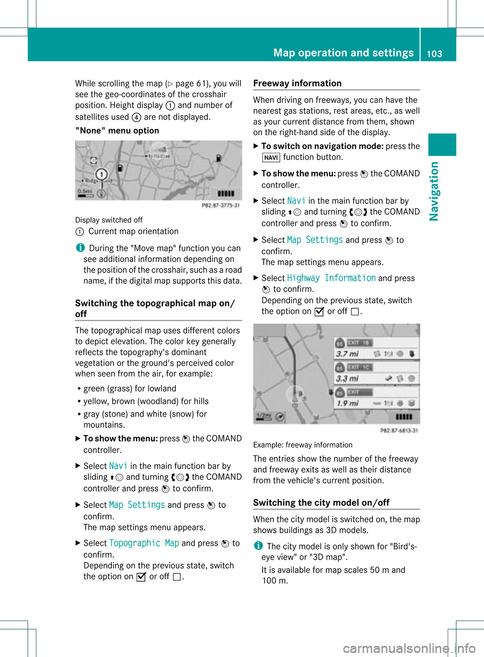
While
scrollin gthe map (Ypage 61),youwill
see thegeo-c oordinat esofthe cross hair
position .Height display :and number of
satellites used?are not displayed.
"None" menuoption Display
switchedoff
: Current maporient ation
i Durin gthe "Move map"function youcan
see additional information depending on
the position ofthe cross hair,such asaroad
name, ifthe digital mapsupports thisdata.
Switching thetopogr aphical map on/
off The
topogr aphical mapuses differen tcolors
to depict elevation. Thecolor keygenerally
reflect sthe topography's dominant
vegetation orthe ground's perceived color
when seenfromtheair,forexample:
R green (grass) forlowland
R yellow ,brown (woodland) forhills
R gray (stone) andwhite (snow) for
mountains.
X To show themenu: pressWthe COMAND
cont roller.
X Select Navi in
the main functionbar by
sliding ZVandturnin gcVd theCOMAND
cont roller andpress Wtoconf irm.
X Select MapSettings and
press Wto
conf irm.
The map settings menu appears.
X Select Topographic Map and
press Wto
conf irm.
Dependin gon the previous state,switch
the option onO oroff ª. Freeway
information When
driving onfreeways, youcan have the
nearest gasstation s,rest areas, etc.,as well
as your current distance fromthem, shown
on the right- hand sideofthe display .
X To switch onnavigation mode:pressthe
Ø functionbutton .
X To show themenu: pressWthe COMAND
cont roller.
X Select Navi in
the main functionbar by
sliding ZVandturnin gcVd theCOMAND
cont roller andpress Wtoconf irm.
X Select MapSettings and
press Wto
conf irm.
The map settings menu appears.
X Select Highway Information and
press
W toconf irm.
Dependin gon the previous state,switch
the option onO oroff ª. Example:
freewayinformation
The entriesshow thenumber ofthe freeway
and freeway exitsaswell astheir distance
from thevehicle's currentposition.
Switching thecity model on/off When
thecity model isswitched on,the map
shows buildingsas3D models.
i The citymodel isonly shown for"Bird's-
eye view" or"3D map".
It is availa bleformap scales 50ma nd
100 m. Map
operatio nand settin gs
103Navi gation Z
Page 107 of 234

Traffi
cin fo rmatio non the map
If yo usu bs cri be tothe SIRIUS XMSate llite
Ra dio Tra fficM essage Service,traff ic
infor mation canbedisplayed onthe map. You
can select three categor iesforthe display.
X To switch thedispla yson/off: pressW
the COMAND controller toshow themenu.
X Select Navi in
the main function barby
sliding ZVandturningcVd theCOMAND
con troller andpress Wtocon firm.
X Select Traffic Informa
tion On Map and
press Wtocon firm.
X Select Inciden ts and/or
Speed&Flow and/or
FreeFlow and
press Wto
con firm.
Depen dingonthe previous state,switch
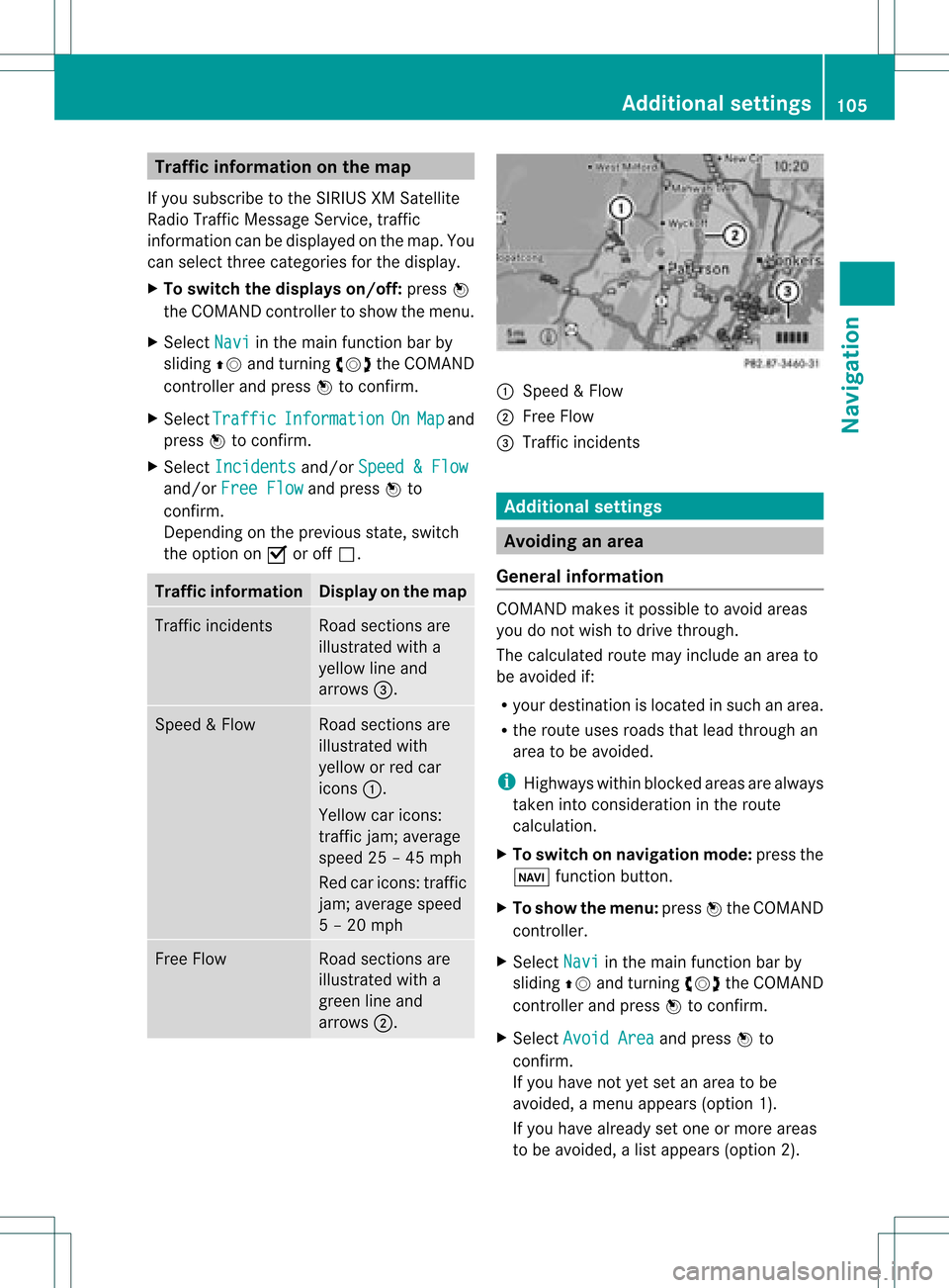
the option onO oroff ª. Tr
affic inform ation Display
onthe map Traffic
inciden ts Road
sections are
illustrated witha
yellow lineand
arrows =. Speed
&Flow Road
sections are
illustr atedwith
yellow orred car
icon s:.
Yellow caricon s:
tr affic jam;average
speed 25–45 mph
Red caricon s:traffic
jam ;average speed
5 –20 mph Fre
eFlow Road
sections are
illustr atedwitha
green lineand
arrows ;. :
Speed &Flow
; FreeFlow
= Traff icinc ident s Add
itiona lsett ings Avoiding
anarea
Gener alinfor mation COMA
NDmak esitpossible toavoid areas
you donot wish todrive through.
The calculated routemay include anarea to
be avoided if:
R your destinationislocat edinsuch anarea.
R the rout euses roads thatlead through an
area tobe avoided.
i Highways withinblockedareas arealways
tak enintocon siderat ioninthe rout e
calc ulation .
X To switch onnaviga tionmod e:press the
Ø function button.
X To show themenu :press Wthe COMA ND
con troller.
X Selec tNavi in
the main function barby
slidin gZV andturnin gcVd theCOMA ND
con troller andpress Wtocon firm .
X Selec tAvoi dArea and
press Wto
con firm .
If you have notyetsetanarea tobe
avoided, amen uappears (option1).
If you have already setone ormor eareas
to be avoided, alist appears (option2). Add
itiona lsett ings
105Navigat ion Z
Page 110 of 234

X
Sel ect SIRIUS Service and
pressW to
confi rm.
The window onthe right halfof the displ ay
sho wsthe telephone numb erofthe
pro vider(SIR IUSXM) andtheserialnumb er
of your ser vice module for rece iving traf fic
mes sages .
Reg isteri ngfor the SIRIU SXM traffic
repo rtse rvic e X
Ca llthe trafficrep ort provider'spho ne
numb ersho wnonthe scre en.
i Youcan also have the satel lite ser vice
acti vate donl ine.Todo so, visit theSIRIUS
XM Radio website at
htt <0010002C00210021001700170017002000130009001200090015001300200003
000F000DH (USA)or
htt <0010002C00210021001700170017002000130009001200090015001300030001
000E000100040001H .com
(Canada) .
Once theconn ection hasbeen established:
X Follow theinstr uctions ofthe operator.
The activation processmaytake uptoten
minutes.
If registrat ionisnot included when
purchasing thesystem, yourcredit card
details willberequired toactivate your
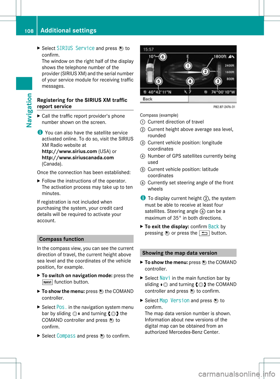
account . Compass
function
In the compass view,youcan seethecurrent
direction oftravel, thecurrent heightabove
sea level andthecoordinat esofthe vehicle
position, forexample.
X To switch onnavigation mode:pressthe
Ø functionbutton .
X To show themenu: pressWthe COMAND
cont roller.
X Select Pos. in
the navigation systemmenu
bar bysliding VÆandturnin gcVd the
COMAND controller andpress Wto
conf irm.
X Select Compass and
press Wtoconf irm. Compass
(example)
: Current direction oftravel
; Current heightaboveaverage sealevel,
rounded
= Current vehicleposition: longitude
coordinat es
? Number ofGPS satellites currentlybeing
used
A Current vehicleposition: latitude
coordinat es
B Currently setsteerin gangle ofthe front
wheels
i Todisplay current height;,thesystem
must beable toreceive atleast four
satellites. Steeringangle Bcan bea
maximum of35° inboth direction s.
X To exit thedisplay: confirmBack by
pressing Worpress the% button . Showing
themap dataversion
X To show themenu: pressWthe COMAND
cont roller.
X Select Navi in
the main functionbar by
sliding ZVandturnin gcVd theCOMAND
cont roller andpress Wtoconf irm.
X Select MapVersion and
press Wto
conf irm.
The map data version number isshown.
Infor mation aboutnewversions ofthe
digital mapcanbeobtained froman
authorized Mercedes-B enzCenter. 108
Additional
settingsNavigation
Page 150 of 234

X
Sel ect acha nnel byturni ngcVd the
CO MAND controllera nd pre ssW to
confi rm.
or
X Pre ssanum berk ey on the control panel,
e.g. 4,atany time. Displaying
stationinform ation
This function isonly available foranalog FM
programs anddigital AM/FMprograms (HD
Radio™).
Inf ormation relevanttothe curren tstat ionis
shown belowthemain function bar.
X Select Radio in
the radio display bysliding
VÆ andturningcVd theCOMAND
con troller andpress Wtocon firm. X
Select ShowStation Information by
sliding VÆandturningcVd theCOMAND
con troller andpress Wtocon firm.
Depen dingonthe previous status,you
switch ShowStation Information on
O oroff ª. Displaying
program information
This function isonly available foranalog FM
programs anddigital AM/FMprograms (HD
Radio™).
Inf ormation relevanttothe curren tstat ionis
shown inthe display window. X
Select Info in
the radio display bysliding
VÆ andturningcVd theCOMAND
con troller andpress Wtocon firm.
Inf ormat iononthe curren tlyselect ed
stat ionisdisplayed. Contentisdependent
on the station. X
To retur nto the radio display: confirm
Info by
pressing W.
X Slide ZVtheCOMAND controller up. Satellite
radio Importa
ntnotes
This section provides detailedinformation on
the followi ngtopics:
R selecting achannel andprogram category
R memory functions
R sound settings
i The satellite radiomode described below
requires optionally available satellite radio
equip ment andregistration withasatellite
radio provider.
i Note thatthecategories andchannels
shown inthe illustrations dependonthe
program contentoffered bythe provider.
The program contents mayvary. The
illu strations anddescriptions inthese
operating instructionsmay therefore differ
from thechannels andcategories offered
by the provider.
Satellite radiomode maybetemporarily
unavail ableorinterrupted foravariety of
reasons. Thesereasons include 148
Satellite
radioAudio
Page 151 of 234

envir
onmen talortopogr aphical conditions
as well asother issues beyond thecontrol
of Mercedes- BenzUSA ,LLC. Operation
may alsobeimpaired incert ainlocation s
(e.g. tunnels,multi-s toreycarparks or
within aswell asclose tobuildings).
i SIRIUS XMRadio offersmore than130
digital-quality radiochann elsproviding
100 %comm ercial-f reemusic, sports,news
and entertain ment.
SIRIUS XMRadio employs afleet ofhigh-
perform ancesatellites tobroadcast around
the clock throughout theUSA andCanada.
The satellite radioprogram isavailable for
a mont hlyfee. Details areavailable from
the SIRIUS XMServ iceCenter andat
htt p://ww w.siriu s.com(USA)or
htt p://ww w.siriu scanada .com
(Canada). Register
ingsatellit erad io
X Switc hon satellite radiomode
(Y page 149).
The satellite radiomainmenu appears
showing theweather channel.You cann ot
select anyother stations.
X Select SatRadio in
the lower menu bar
and press Wtocon firm.
X Select Service and
press Wtocon firm.
The servic einfor mation screenappears. Serv
iceinfor mation screen
1 Provider's phonenumber (SIRIUSXM)
2 SIRIUS XMIDofyour satellite receiver X
Call thephone number ofyour satellite
radio provider shownonthe screen .
i You canalso have thesatellite service
activ ated online. Todo so, visit theSIRIUS
XM Radio website at
htt p://ww w.siriu s.com(USA)or
htt p://ww w.siriu scanada .com
(Canada).
Onc ethe connection hasbeen established:
X Follow theinstruct ions ofthe servic estaff .
The activ ation process maytake uptoten
minut es.Ifthe activ ation iscomplet ed
success fully,theNoService message
appears inthe display, followed bythe
satellite radiomainmenu.
i Ifregistr ationisnot included when
purchasing thesystem, yourcredit card
details willberequired toactivat eyour
accoun t.
If the satellite receiver isnot installed or
inst alled incorrectly,the Device unavail
able message
willappear. Switching
onsatellit erad iomode
Notes You
canalso usethemultifunc tionsteer ing
wheel totune inchann elsorscroll through
lists, e.g.bypressing the=;
9: buttons(Y page 23).
For import antnoteson registr ation,see
"Registering satelliteradio"(Y page 149).
Opt ion 1 X
Press $thefunc tion button .
The NoService message
appearsafter
switch ingonorifno signal isbeing
received. OnceCOMAND receivesthe
signal, thesatellite radiodisplay appears.
The stationlast select edisplayed.
i Repeatedly pressingthisfunc tion button
switch esthrough thewavebands inthe
order FM,AM, WBand subsequently Sat
ellite radio
149Audio
Page 152 of 234

switches
onthe satellite radio.Pressing the
button againtake syou back toFM radio
mod e.
Opt ion 2 X
Sel ect Audio in
themain function bar by
slidin gZV andturnin gcVd theCOMA ND
co ntroll erand pres sW toconfirm .
If sat ellit eradio modewas thelast mod e
selec ted, itwill nowbe act ive.
If ano ther audio modeis swit ched on,you
can nowswit chtosat ellit eradio modein
th eaudio menu.
X Sel ect Audio by
slidin gZV theCOMA ND
co ntroll erand pres sW toconfirm .
The audio menuappear s.
X Sel ect Sat Rad
io and
pres sW toconfirm .
The NoService mes
sage appear swhen
st art ing uporifno sign alisbein grec eive d.
If th esat ellit erec eive risnot installed oris
not installed correctly,the Device Unavailable message
willappea r. Once
COMAND receivesthesignal, the
satellite radiodispla yappea rs.The station
last selected isplay ed. Satellite
radiomainmenu
1 Satellite radiomaindispla y
2 Channel name
3 Preset
4 Selected category/channel number
5 Channel information (inbrief)
6 Sound settings
7 Category list
8 Channel information (indetail)
9 Channel presetlist
a Satellite radiomenu
Channel information Acan beviewed in
detail (Ypage 153).
Changing thecategory Satellite
radiostations aresorted intovarious
categories. Youcanchoose between the
different categories, suchasnews/talk
shows, sportsorcountry, ifthey areavail able.
The category listissorted alphabetically .
Selec tingacatego ry
X To callup the categ orylist:sel ect
Catego ry by
turning cVdtheCOM AND
controlle rand pre ssW toconfi rm.
The cate gorylist appe ars.
X To select ac atego ry:select acatego ryby
turning cVdtheCOM AND controll erand
pres sing Wtoconfirm.
The catego rysel ected isshow nint he
displa y.You hear thestation lastselected
for this category.
The All Channels category
isat the top
of the category list.This category issorted 150
Satellite
radioAudio