2011 MERCEDES-BENZ SLS light
[x] Cancel search: lightPage 104 of 436

Map Data is not yet installed
The version release and a query as to whether
the update should be carried out will be given
on the display.XSelect Yes or No.
If No is selected, COMAND ejects the DVD
automatically and the map data is not
updated.XRemove the DVD from the slot.
If Yes is selected, the map data is updated.
Updating the Map Data
While the update is in progress, a
corresponding message and a progress bar
are displayed. The progress bar fills from left
to right over the course of the update. The
navigation system is not functional until the
update is complete.
You cannot eject the DVD during the update.
If you switch COMAND off during the update,
this will interrupt the update and the update
will resume at the point of interruption when
the system is restarted.
While updating, COMAND may prompt you to
change the DVD. A corresponding message
is then displayed.
XPress the Load button 8.
The magazine menu appears. The magazine
compartment containing the current disc is
highlighted.XPress 9.
COMAND ejects the DVD.XRemove the DVD from the slot.XInsert the DVD requested by COMAND.
If the update has been completed
successfully, a corresponding message is
displayed.XTo confirm message: Press n.
COMAND ejects the DVD.XRemove the DVD from the slot.
The update is complete.
If the update has not been completed
successfully, a message is displayed
indicating that the map update is not
possible.
XTo confirm message: Press n.
COMAND ejects the DVD.XRemove the DVD from the slot.
An unsucessful update may be caused by one
of the following:
R DVD dirty or scratched.
R Overheating as a result of excessively high
temperatures in the passenger
compartment.
Input Restriction
There is an input restriction for vehicles in
certain countries.
The restriction is active for vehicle speeds
above approx. 3 mph. The restriction is
deactivated as soon as the speed falls below
approx. 2 mph.
Certain entries cannot be made when the
restriction is active, e.g. a city or road entry.
This is indicated by the fact that certain menu
items cannot be selected.
General Information
Operational Readiness of the
Navigation System after the System
Software Update
Sometimes the installed map software is no
longer compatible following a system
software update by an authorized Mercedes-
Benz Center. In this case, the navigation
system is not operational.
XTo update map software: Proceed as
described in the “Update Process” section
( Y page 101). Use map software
compatible with the system software.
i Please note that in this case the update
must run through right to the end. If you
cancel beforehand, the navigation system
will still not be ready for operation.
After start-up or initial start-up, the navigation
system must perform a position finding
102Navigation (Introduction)COMAND APS
BA 197 USA, CA Edition A 2011; 1; 27, en-UShereepeVersion: 3.0.3.52010-03-24T15:31:10+01:00 - Seite 102
Page 117 of 436
RLast States/Provinces
RStates (U.S.A.) or
RProvinces (Canada).
XTo select a list: Rotate y m z or slide
q m r.
XPress n.
The selected state/province list appears.
XTo selected a state/province: Rotate
y m z or slide q m r.
XPress n.
The Enter Destination menu appears again.
The selected state/province has been
entered automatically.
Entering a City
iYou can only enter those cities that are
stored in the digital map. Any zip code that
has already been entered is deleted when
a city is entered.
XIn the Enter Destination menu, select
City.
The city list is displayed with or without
predictive speller. The display of the
predictive speller depends on how many
cities are available for the selected state/
province.
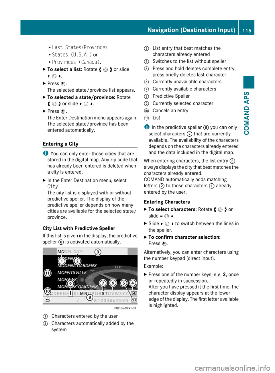
City List with Predictive Speller
If this list is given in the display, the predictive
speller 8 is activated automatically.
1 Characters entered by the user2 Characters automatically added by the
system
3 List entry that best matches the
characters already entered
4 Switches to the list without speller5 Press and hold deletes complete entry,
press briefly deletes last character
6 Currently unavailable characters7 Currently available characters8 Predictive Speller9 Currently selected charactera Cancels an entryb List
iIn the predictive speller 8 you can only
select characters 7 that are currently
available. The availability of the characters
depends on the characters already entered
and the data included in the digital map.
When entering characters, the list entry 3
always displays the city that best matches the
characters already entered.
COMAND automatically adds matching
letters 2 to those characters 1 already
entered by the user.
Entering Characters
XTo select characters: Rotate y m z or
slide o m p.
XSlide q m r to switch between the lines in
the speller.
XTo confirm character selection:
Press n.
Alternatively, you can enter characters using
the number keypad (direct input).
Example:
XPress one of the number keys, e.g. 2, once
or repeatedly in succession.
After you have pressed it the first time, the
character display appears at the lower
edge of the display. The first letter available
is highlighted.
Navigation (Destination Input)115COMAND APSBA 197 USA, CA Edition A 2011; 1; 27, en-UShereepeVersion: 3.0.3.52010-03-24T15:31:10+01:00 - Seite 115Z
Page 118 of 436
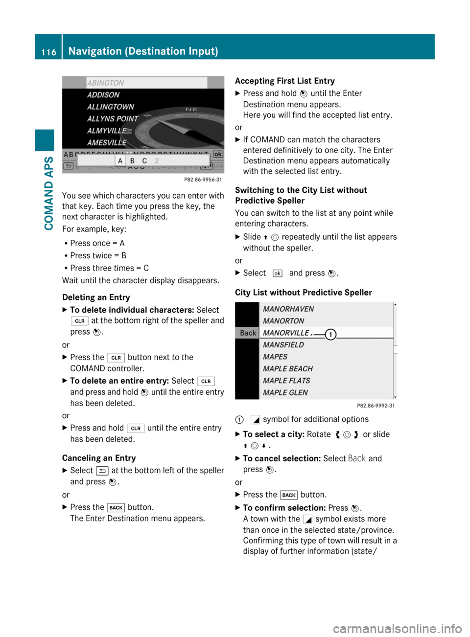
You see which characters you can enter with
that key. Each time you press the key, the
next character is highlighted.
For example, key:
RPress once = A
RPress twice = B
RPress three times = C
Wait until the character display disappears.
Deleting an Entry
XTo delete individual characters: Select
õ at the bottom right of the speller and
press n.
or
XPress the 2 button next to the
COMAND controller.
XTo delete an entire entry: Select õ
and press and hold n until the entire entry
has been deleted.
or
XPress and hold 2 until the entire entry
has been deleted.
Canceling an Entry
XSelect á at the bottom left of the speller
and press n.
or
XPress the k button.
The Enter Destination menu appears.
Accepting First List EntryXPress and hold n until the Enter
Destination menu appears.
Here you will find the accepted list entry.
or
XIf COMAND can match the characters
entered definitively to one city. The Enter
Destination menu appears automatically
with the selected list entry.
Switching to the City List without
Predictive Speller
You can switch to the list at any point while
entering characters.
XSlide q m repeatedly until the list appears
without the speller.
or
XSelect d and press n.
City List without Predictive Speller
: G symbol for additional optionsXTo select a city: Rotate y m z or slide
q m r .
XTo cancel selection: Select Back and
press n.
or
XPress the k button.XTo confirm selection: Press n.
A town with the G symbol exists more
than once in the selected state/province.
Confirming this type of town will result in a
display of further information (state/
116Navigation (Destination Input)COMAND APS
BA 197 USA, CA Edition A 2011; 1; 27, en-UShereepeVersion: 3.0.3.52010-03-24T15:31:10+01:00 - Seite 116
Page 119 of 436
province/region) on the towns. The G
symbol then switches to I.
If no other options exist, the Enter Destination
menu appears again in the display.
COMAND has accepted the selected city and
entered it automatically in the Enter
Destination menu.
Entering a Zip Code
iYou can only enter those zip codes that
are stored in the digital map. For some
countries it is not possible to enter any zip
code.
XIn the Enter Destination menu select ZIP.
The zip code list is displayed with or without
predictive speller (Y page 115). The display
of the predictive speller depends on how
many zip codes are available for the
selected state/province.
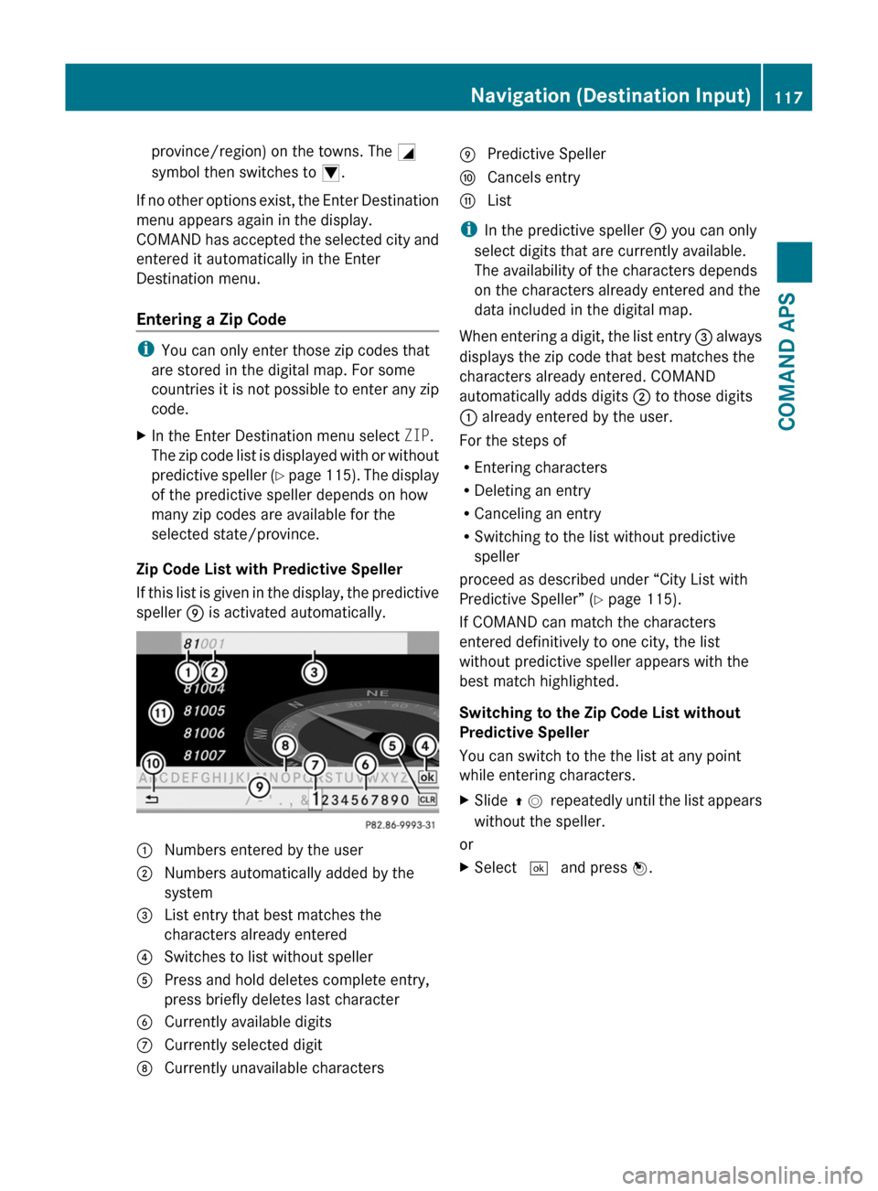
Zip Code List with Predictive Speller
If this list is given in the display, the predictive
speller 9 is activated automatically.
1 Numbers entered by the user2 Numbers automatically added by the
system
3 List entry that best matches the
characters already entered
4 Switches to list without speller5 Press and hold deletes complete entry,
press briefly deletes last character
6 Currently available digits7 Currently selected digit8 Currently unavailable characters9 Predictive Spellera Cancels entryb List
iIn the predictive speller 9 you can only
select digits that are currently available.
The availability of the characters depends
on the characters already entered and the
data included in the digital map.
When entering a digit, the list entry 3 always
displays the zip code that best matches the
characters already entered. COMAND
automatically adds digits 2 to those digits
1 already entered by the user.
For the steps of
REntering characters
RDeleting an entry
RCanceling an entry
RSwitching to the list without predictive
speller
proceed as described under “City List with
Predictive Speller” (Y page 115).
If COMAND can match the characters
entered definitively to one city, the list
without predictive speller appears with the
best match highlighted.
Switching to the Zip Code List without
Predictive Speller
You can switch to the the list at any point
while entering characters.
XSlide q m repeatedly until the list appears
without the speller.
or
XSelect d and press n.Navigation (Destination Input)117COMAND APSBA 197 USA, CA Edition A 2011; 1; 27, en-UShereepeVersion: 3.0.3.52010-03-24T15:31:10+01:00 - Seite 117Z
Page 133 of 436
iIn the predictive speller 3 you can only
select characters that are currently
available. The set of characters that is
available depends on those already entered
and the data included in the digital map.
For the steps of
REntering characters
RDeleting an entry
RAccepting first list entry
RCanceling an entry
proceed as described under “Main category
list with predictive speller” (Y page 128).
Selecting a POI
To accept first list entry:
XPress and hold n until the list appears
without speller.
or
If COMAND can match the characters
entered definitively to one entry, the list is
displayed without predictive speller with the
matching entry highlighted.(Y page 130).
You can switch to the list at any point while
entering characters.
XSlide q m repeatedly until the list appears
without the speller.
or
XSelect d and press n.XTo display the full address of the POI:
Select ? and press n.
XTo cancel selection: Press the k
button.
or
XSelect Back.
The POI list appears.
XTo start route calculation: Select Start.
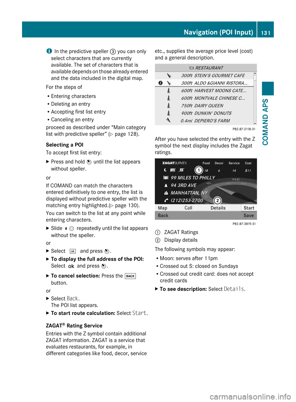
ZAGAT® Rating Service
Entries with the Z symbol contain additional
ZAGAT information. ZAGAT is a service that
evaluates restaurants, for example, in
different categories like food, decor, service
etc., supplies the average price level (cost)
and a general description.
After you have selected the entry with the Z
symbol the next display includes the Zagat
ratings.
1 ZAGAT Ratings2 Display details
The following symbols may appear:
RMoon: serves after 11pm
RCrossed out S: closed on Sundays
RCrossed out credit card: does not accept
credit cards
XTo see description: Select Details.Navigation (POI Input)131COMAND APSBA 197 USA, CA Edition A 2011; 1; 27, en-UShereepeVersion: 3.0.3.52010-03-24T15:31:10+01:00 - Seite 131Z
Page 134 of 436

ZAGAT example description
Entering a POI via the Map
iIf the crosshairs are visible on the map,
you can enter POIs in the vicinity of the
crosshairs. If the crosshairs are not visible,
you can enter POIs in the vicinity of the
current vehicle location.
XIn the map display with the menu system
displayed (Y page 105) select Guide.
POIs are available:
Depending on the map scale selected, POI
symbols are displayed on the map. The
scale starting at which symbols are
displayed on the map varies from symbol
to symbol.
You can select which symbols COMAND
should display (Y page 108). The POI
nearest to the center of the screen is
selected automatically.
No POIs available:
A corresponding message is displayed.
iThis message is also displayed if the menu
item No Symbols under Map Display has
been selected (Y page 108).
XTo confirm message: Press n.1 Information about the highlighted POI2 Highlighted POIXTo select a POI: Select Next or
Previous.
XTo start route calculation: Select Start,
see also (Y page 121).
You will be asked whether the POI should
be adopted as the destination.
XSelect Yes or No.
Route calculation starts if Yes is selected;
a new POI can be chosen if No is selected.
Navigation (Route Guidance)
General Notes
GWarning
COMAND calculates the route to the
destination without taking account of the
following, for example:
RTraffic lights
RStop and right-of-way signs
RLane merging
RParking or stopping prohibited areas
ROther road and traffic rules and regulations
RNarrow bridges
COMAND may give incorrect navigation
commands if the data in the digital map does
not correspond with the actual road/ traffic
situation. For example, if the traffic routing
has been changed or the direction of a one-
way road has been reversed.
For this reason, you must always observe
applicable road and traffic rules and
132Navigation (Route Guidance)COMAND APS
BA 197 USA, CA Edition A 2011; 1; 27, en-UShereepeVersion: 3.0.3.52010-03-24T15:31:10+01:00 - Seite 132
Page 137 of 436
Traffic Lane Recommendations
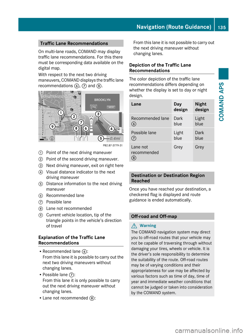
On multi-lane roads, COMAND may display
traffic lane recommendations. For this there
must be corresponding data available on the
digital map.
With respect to the next two driving
maneuvers, COMAND displays the traffic lane
recommendations 6, 7 and 8.
1 Point of the next driving maneuver2 Point of the second driving maneuver.3 Next driving maneuver, exit on right here4 Visual distance indicator to the next
driving maneuver
5 Distance information to the next driving
maneuver
6 Recommended lane7 Possible lane8 Lane not recommended9 Current vehicle location, tip of the
triangle points in the vehicle’s direction
of travel
Explanation of the Traffic Lane
Recommendations
RRecommended lane 6:
From this lane it is possible to carry out the
next two driving maneuvers without
changing lanes.
RPossible lane 7:
From this lane it is only possible to carry
out the next driving maneuver without
changing lanes.
RLane not recommended 8:
From this lane it is not possible to carry out
the next driving maneuver without
changing lanes.
Depiction of the Traffic Lane
Recommendations
The color depiction of the traffic lane
recommendations differs depending on
whether the display is set to day or night
design.
LaneDay
design
Night
design
Recommended lane
6
Dark
blue
Light
blue
Possible lane
7
Light
blue
Dark
blue
Lane not
recommended
8
GreyGrey
Destination or Destination Region
Reached
Once you have reached your destination, a
checkered flag is displayed and route
guidance is ended automatically.
Off-road and Off-map
GWarning
The COMAND navigation system may direct
you to off-road routes that your vehicle may
not be capable of traversing through without
damaging your tires, wheels or vehicle. It is
the driver’s sole responsibility to determine
the suitability of the route. Off-road routes
may be of varying conditions and their
appropriateness for use may be affected by
various factors such as time of day, time of
year and immediate weather conditions that
cannot be judged or taken into consideration
by the COMAND system.
Navigation (Route Guidance)135COMAND APSBA 197 USA, CA Edition A 2011; 1; 27, en-UShereepeVersion: 3.0.3.52010-03-24T15:31:10+01:00 - Seite 135Z
Page 140 of 436
XTo set the length of block: Select
Longer or Shorter repeatedly until the
required length is set.
The blocked segment is highlighted in red/
white on the map. Shown at the top of the
display is the length of the blocked
segment and the route segment to which
the block goes.XTo cancel the function: Select Back.XTo start route calculation: Select Start,
see also ( Y page 121).XTo delete block: In map view with the
menu system displayed, select Route £
Detour £ Delete .
Alternative Route
i You can have other routes calculated for
the original route guidance using the
Alternative Route function.
XIn the map display with the menu system
displayed ( Y page 106) select Route £
Alternative Route .
The display is split into two halves. On the
left is the map, which displays one or more
alternative routes between the start and
the destination. The current route is
highlighted in dark blue, other alternative
routes are light blue (day mode). If the
display is in night mode, the representation
is inverse.
The right side of the display shows
information on the active alternative route,
e.g. length of the segment and the
estimated time of arrival.XTo select next or previous alternative
route: Select Next or Previous .
The selected route is now highlighted in
dark blue.XTo return to the original route guidance:
Select Back.XTo start route guidance with the
selected alternative route guidance:
Select Start.Route Browser
i The route browser provides an overview
of the route. You can move along the route
segment by segment using the route
browser and view information and details
about the route segments.XIn the map display with the menu system
displayed, select Route £ Route
Browser .
The route browser is in the display.
The top of the display shows information on
the highlighted route segment, e.g. the
road name or number and the segment
length of the road to be driven.
The highlighted route segment is identified
on the map by its white color and red edge.XTo display next or previous route
segment: Select Next or Previous .XTo enlarge or reduce the map display:
Select ; or :.XTo close route browser: Select Back.
Displaying Destination Information
XIn the map display with the menu system
( Y page 106) shown, select Route £
Destination Information .
The destination information is given in the
display.138Navigation (Route Guidance)COMAND APS
BA 197 USA, CA Edition A 2011; 1; 27, en-UShereepeVersion: 3.0.3.52010-03-24T15:31:10+01:00 - Seite 138