2011 MERCEDES-BENZ S-Class Start
[x] Cancel search: StartPage 159 of 524
XTo switch on navigation mode: press the
S function button once or twice.
XTo show the menu: press the COMAND
controller W.
XSelect Destination in the navigation
system menu bar by turning cVd the
COMAND controller and press W to
confirm.
XSelect From Memory and press W to
confirm.
XSelect My Address by turning cVd the
COMAND controller.
XIrrespective of the option chosen, press
W to confirm your selection.
"My address" has been entered.
XTo start route calculation: select Start
and press W to confirm.
Entering a destination from the list of
last destinations
XTo switch on navigation mode: press the
S function button once or twice.
XTo show the menu: press the COMAND
controller W.
XSelect Destination in the navigation
system menu bar by turning cVd the
COMAND controller and press W to
confirm.
XSelect From Last Destinations and
press W to confirm.
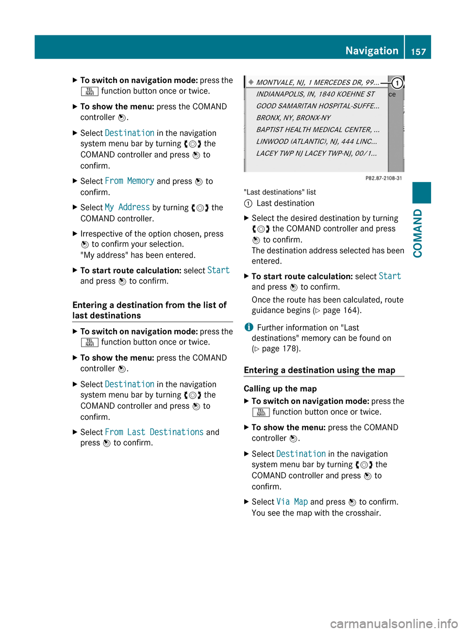
"Last destinations" list
:Last destinationXSelect the desired destination by turning
cVd the COMAND controller and press
W to confirm.
The destination address selected has been
entered.
XTo start route calculation: select Start
and press W to confirm.
Once the route has been calculated, route
guidance begins (Y page 164).
iFurther information on "Last
destinations" memory can be found on
(Y page 178).
Entering a destination using the map
Calling up the map
XTo switch on navigation mode: press the
S function button once or twice.
XTo show the menu: press the COMAND
controller W.
XSelect Destination in the navigation
system menu bar by turning cVd the
COMAND controller and press W to
confirm.
XSelect Via Map and press W to confirm.
You see the map with the crosshair.
Navigation157COMANDZ
Page 160 of 524

:Current vehicle position;Crosshair=Details of the crosshair position?Map scale selected
Display = depends on the settings selected
in "Map information in the display"
(Y page 182). The current street name can
be shown, provided the digital map contains
the necessary data, or the coordinates of the
crosshair if the geo-coordinate display is
switched on and the GPS signal is strong
enough.
Moving the map and selecting the
destination
XTo scroll the map: slide the COMAND
controller XVY, ZVÆ or aVb.
XTo set the map scale: as soon as you turn
cVd the COMAND controller, the scale bar
appears.
XTurn cVd until the desired scale is set.
Turning clockwise zooms out from the map,
turning counter-clockwise zooms in.
XTo select a destination: press W the
COMAND controller once or several times.
You will see either the address entry menu
with the destination address or, if COMAND
is unable to assign a unique address, a
selection list.
XSelect a destination by turning cVd the
COMAND controller and press W to
confirm.
If the destination is within the limits of the
digital map, COMAND attempts to assign
the destination to the map.
If the destination can be assigned, you will
see the address entry menu with the
address of the destination. If not, you will
see the Destination from Map entry.
XTo start route calculation: select Start
and press W to confirm.
Entering an intermediate stop
Introduction
When route guidance is active, you can enter
an intermediate stop. Intermediate stops can
be predefined destinations from the following
categories that COMAND offers for selection:
RMercedes-Benz Service Center
RHospital
RGas Station
RParking Lot
RRestaurant
However, you can also enter destinations
other than the predefined ones. To do this,
select the menu item Other.
You can use the intermediate stop function to
influence route guidance to the main
destination. When you have reached your
intermediate stop, COMAND automatically
recalculates the route to the main
destination.
158NavigationCOMAND
Page 161 of 524
Entering predefined destinationsXTo switch on navigation mode: press the
S function button once or twice.XTo show the menu: press the COMAND
controller W.XSelect Destination in the navigation
system menu bar by turning cVd the
COMAND controller and press W to
confirm.XSelect Stopover and press W to confirm.
Option 1: no intermediate stop has been
entered yet.
XSelect a category, see option 2.
Option 2: an intermediate stop has
already been entered.
XSelect Change Stopover and press W to
confirm.XTo select a category: select a category by
turning cVd the COMAND controller and
press W to confirm.
COMAND first searches in the selected
category for destinations along the route.
If there are no destinations available there,
COMAND searches for destinations within
a radius of up to 100 km (approx. 60 mi) of
the vehicle position.
If COMAND finds destinations, a list
appears on the right-hand side of the
display.
The intermediate stops are listed according
to increasing distance from the current
vehicle position. They are displayed in the
form of a name and their position in relation
to the route and your direction of travel.
i For intermediate stops that are not
located along the calculated route, the
linear distance is shown.
If COMAND does not find any destinations,
you will see a message to this effect.
XConfirm OK by pressing W.XSelect a different category.XSelect the intermediate stop by turning
cVd the COMAND controller and press
W to confirm.XTo start route calculation: select Start
and press W to confirm.
Entering another destination as an
intermediate stop
XTo switch on navigation mode: press the
S function button once or twice.XTo show the menu: press the COMAND
controller W.XSelect Destination in the navigation
system menu bar by turning cVd the
COMAND controller and press W to
confirm.XSelect Stopover and press W to confirm.XSelect Other and press W to confirm.XSelect Address Entry , From Memory ,
From Last Destinations or From POIs .SelectionStepAddress EntryXEnter a
destination by
address
( Y page 151).From MemoryXSelect a
destination from
the destination
memory
( Y page 156).From Last
DestinationsXSelect a
destination from
the list of last
destinations
( Y page 157).From POIsXEnter a point of
interest
( Y page 160).Navigation159COMANDZ
Page 162 of 524
XTo start route calculation: once you have
entered a destination, select Start and
press W to confirm.
Deleting the intermediate stop
If an intermediate stop has already been
entered, you can delete it.
XTo switch on navigation mode: press the
S function button once or twice.XTo show the menu: press the COMAND
controller W.XSelect Destination in the navigation
system menu bar by turning cVd the
COMAND controller and press W to
confirm.XSelect Stopover and press W to confirm.XSelect Delete Stopover and press W to
confirm.
COMAND deletes the intermediate stop
and recalculates the route to the main
destination.
Entering points of interest
Initiating point of interest entry
XTo switch on navigation mode: press the
S function button once or twice.XTo show the menu: press W the COMAND
controller.XSelect Destination in the navigation
menu bar by turning cVd the COMAND
controller and press W to confirm.XSelect From POIs and press W to confirm.
A menu appears.
Entering a point of interest in the
vicinity of the destination
Entering a point of interest in the vicinity of
the destination is only possible when route
guidance is active.
XSelect Destination Area from the menu
and press W to confirm.XContinue with assigning the point of
interest category ( Y page 161).
Entering a point of interest in the
vicinity of the current position
XSelect Current Position from the menu
and press W to confirm.XContinue with assigning the point of
interest category ( Y page 161).
Entering a point of interest in the
vicinity of a city
Option 1
XSelect Other City from the menu and
press W to confirm.XIf desired, select the state/province
( Y page 152).XTo enter a city: select City and press W
to confirm.
Proceed as described in the "Entering a
city" section ( Y page 152).XAfter entering the city, assign the point of
interest category ( Y page 161).
Option 2
XEnter an address in the address entry
menu, e.g. as city, street and house number
( Y page 151).XSelect POI and press W to confirm.XAssign a point of interest category
( Y page 161).
Entering a point of interest using name
search
This function gives you access to all points of
interest available in the digital map.
160NavigationCOMAND
Page 164 of 524
list contains all the points of interest which
cannot be assigned to any sub-category of
the Restaurant main category and that lie
within the search radius.
Point of interest list
Introduction
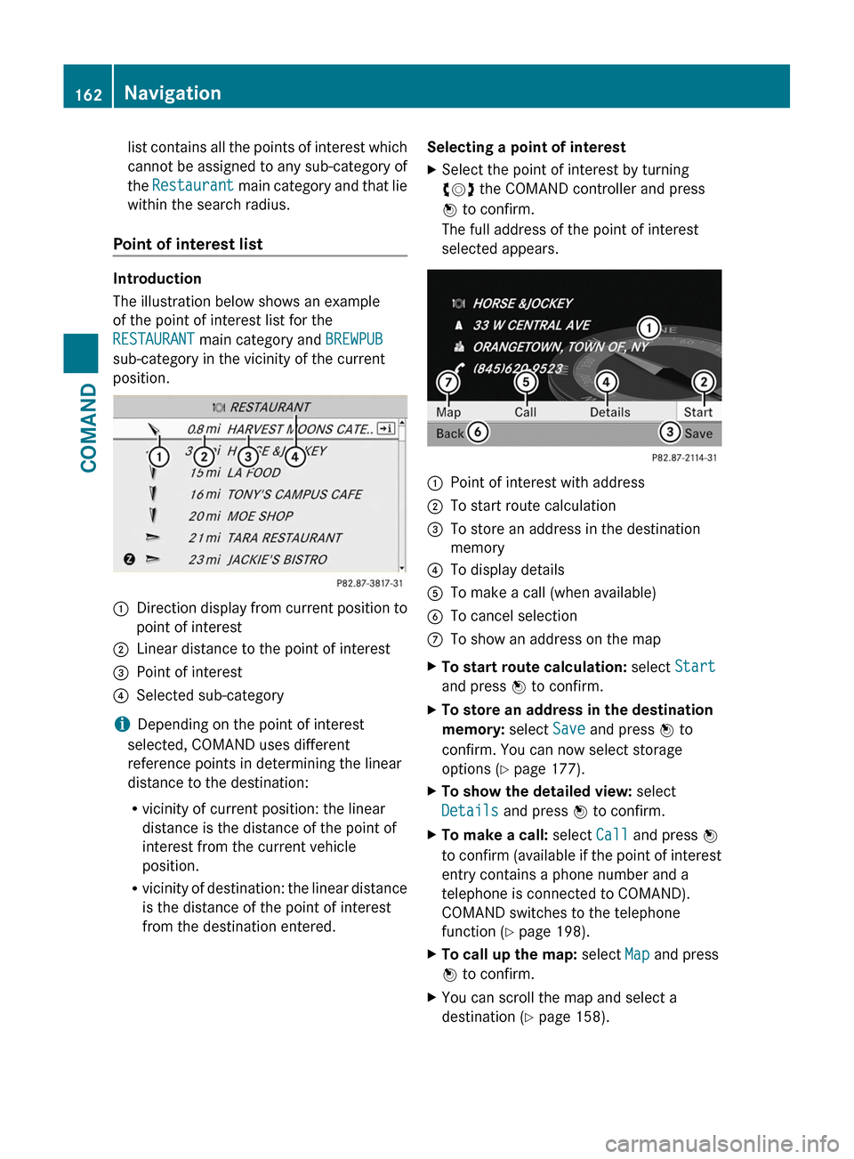
The illustration below shows an example
of the point of interest list for the
RESTAURANT main category and BREWPUB
sub-category in the vicinity of the current
position.
:Direction display from current position to
point of interest
;Linear distance to the point of interest=Point of interest?Selected sub-category
iDepending on the point of interest
selected, COMAND uses different
reference points in determining the linear
distance to the destination:
Rvicinity of current position: the linear
distance is the distance of the point of
interest from the current vehicle
position.
Rvicinity of destination: the linear distance
is the distance of the point of interest
from the destination entered.
Selecting a point of interestXSelect the point of interest by turning
cVd the COMAND controller and press
W to confirm.
The full address of the point of interest
selected appears.
:Point of interest with address;To start route calculation=To store an address in the destination
memory
?To display detailsATo make a call (when available)BTo cancel selectionCTo show an address on the mapXTo start route calculation: select Start
and press W to confirm.
XTo store an address in the destination
memory: select Save and press W to
confirm. You can now select storage
options (Y page 177).
XTo show the detailed view: select
Details and press W to confirm.
XTo make a call: select Call and press W
to confirm (available if the point of interest
entry contains a phone number and a
telephone is connected to COMAND).
COMAND switches to the telephone
function (Y page 198).
XTo call up the map: select Map and press
W to confirm.
XYou can scroll the map and select a
destination (Y page 158).
162NavigationCOMAND
Page 170 of 524

XSelect Continue Route Guidance and
press W to confirm.
COMAND calculates the route.
Destination or area of destination
reached
When you reach your destination, COMAND
displays a checkered flag and route guidance
is automatically ended.
For certain points of interest (e.g. airports),
you will see the Area of destination
reached message in addition to the
checkered flag.
Navigation announcements
Repeating navigation announcements
GWarning
Navigation announcements are intended to
direct you while driving without diverting your
attention from the road and driving.
Please always use this feature instead of
consulting the map display for directions.
Looking at the icons or map display can
distract you from traffic conditions and
driving, and increase the risk of an accident.
i Audible navigation announcements are
muted during a telephone call.
If you have missed an announcement, you can
call up the current announcement at any
time.
XTo show the menu: press W the COMAND
controller.XConfirm RPT in the navigation menu by
pressing W.
Switching navigation announcements
on/off
XTo switch off: press the 8 button
during an announcement.
You will briefly see the message: The
driving instructions have been
muted .XTo switch on: press W the COMAND
controller.XConfirm + in the navigation menu by
pressing W.
i COMAND automatically switches the
navigation announcements back on when:
R you have a new route calculated.
R you start the engine again after having
left the vehicle.
Reducing volume during a navigation
announcement
The volume of an active radio or video source
can be automatically reduced during a
navigation announcement.
XSelect Navi in the main function bar by
sliding ZV and turning cVd the COMAND
controller and press W to confirm.XSelect Audio Fadeout and press W to
confirm.
The function is switched on O or off ª,
depending on the previous status.
Setting the volume manually
XAdjust the volume during a navigation
announcement.
or
XSelect + in the map view with the menu
shown and adjust the volume.
Avoiding a section of the route blocked
by a traffic jam
This function blocks a section of the route
ahead of you. The length of the section of
route to be blocked can be adjusted. If
possible, COMAND calculates a detour
around the blocked section of the route.
XTo switch on navigation mode: press the
S function button once or twice.XTo show the menu: press the COMAND
controller W.168NavigationCOMAND
Page 171 of 524

XSelect Route in the navigation menu bar by
turning cVd the COMAND controller and
press W to confirm.
XSelect Detour and press W to confirm.XTo block a section of the route: select
More or Less repeatedly and confirm using
the W button until the desired section has
been selected.
iThe length of the blockable route section
is predetermined by the digital map. The
menu items are available accordingly.
XTo start route calculation: select Start
and press W to confirm.
XTo delete the blocked section: select
Delete while the message is shown and
press W to confirm.
COMAND calculates the route without the
block.
Selecting an alternative route
With the "Alternative route" function, routes
other than the original one can be calculated.
XTo switch on navigation mode: press the
S function button once or twice.
XTo show the menu: press W the COMAND
controller.
XSelect Route in the navigation menu bar by
turning cVd the COMAND controller and
press W to confirm.
XSelect Alternative Route and press W
to confirm.
You see the selected route. The display now
shows a split-screen view. On the left-hand
side, one or more alternative routes are
shown from start to destination. The
current route is highlighted dark blue; other
alternative routes appear light blue.
:Distance, estimated time of arrival and
estimated remaining driving time
;Display of events on the route=Display of selected route settingXTo select the next or previous
alternative route: select Next or
Previous and press W to confirm.
The possible alternative routes are shown
in this order: Current Route, Fast
Route, Eco Route, Short Route and
Alternative Route.
XTo select the original route: select Back
as often as necessary and press W to
confirm.
XTo start route guidance using the
selected alternative route: select Start
and press W to confirm.
COMAND accepts the alternative route.
Displaying destination information
Requirement: you have entered a destination
(Y page 151) and possibly an intermediate
stop (Y page 158).
XTo switch on navigation mode: press the
S function button once or twice.
XTo show the menu: press W the COMAND
controller.
XSelect Info in the navigation menu bar by
turning cVd the COMAND controller and
press W to confirm.
Destination information is displayed.
Navigation169COMANDZ
Page 173 of 524
XTo show the menu: press the COMAND
controller W.
XSelect Position in the navigation menu
bar by turning cVd the COMAND
controller and press W to confirm.
XSelect Where am I? and press W to
confirm.
Off-road and off-map
Important safety notes
GWarning
The COMAND navigation system may direct
you to off-road routes that your vehicle may
not be capable of traversing through without
damaging your tires, wheels or vehicle. It is
the driver’s sole responsibility to determine
the suitability of the route. Off-road routes
may be of varying conditions and their
appropriateness for use may be affected by
various factors such as time of day, time of
year and immediate weather conditions that
cannot be judged or taken into consideration
by the COMAND system.
Route guidance to a destination that is on
a non-digitized road
COMAND can guide you to destinations
which are within the area covered by the
digital map, but which are not themselves
recorded on the map.
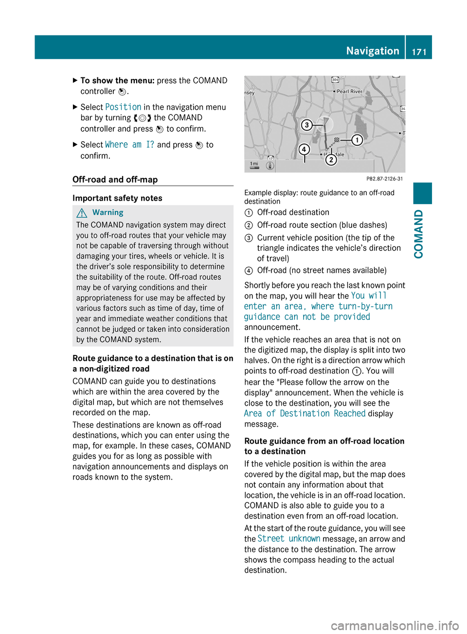
These destinations are known as off-road
destinations, which you can enter using the
map, for example. In these cases, COMAND
guides you for as long as possible with
navigation announcements and displays on
roads known to the system.
Example display: route guidance to an off-roaddestination
:Off-road destination;Off-road route section (blue dashes)=Current vehicle position (the tip of the
triangle indicates the vehicle’s direction
of travel)
?Off-road (no street names available)
Shortly before you reach the last known point
on the map, you will hear the You will
enter an area, where turn-by-turn
guidance can not be provided
announcement.
If the vehicle reaches an area that is not on
the digitized map, the display is split into two
halves. On the right is a direction arrow which
points to off-road destination :. You will
hear the "Please follow the arrow on the
display" announcement. When the vehicle is
close to the destination, you will see the
Area of Destination Reached display
message.
Route guidance from an off-road location
to a destination
If the vehicle position is within the area
covered by the digital map, but the map does
not contain any information about that
location, the vehicle is in an off-road location.
COMAND is also able to guide you to a
destination even from an off-road location.
At the start of the route guidance, you will see
the Street unknown message, an arrow and
the distance to the destination. The arrow
shows the compass heading to the actual
destination.
Navigation171COMANDZ