2011 HONDA FIT buttons
[x] Cancel search: buttonsPage 40 of 152
Navigation System39
If this is the desired address, push in on the joystick again. If not, use the joystick to reposition the crosshairs, then push in on th e joystick again to display the new address.
If you selected a single icon or road segment, push in on the joystick again to select the new address. If you selected multiple icons within the cursor radius, select an item from the list on the screen.
Once you select an address, the system then displays the Calculate route to screen (see Driving to Your Destination on page 45).
Showing the Map of Continental
USA
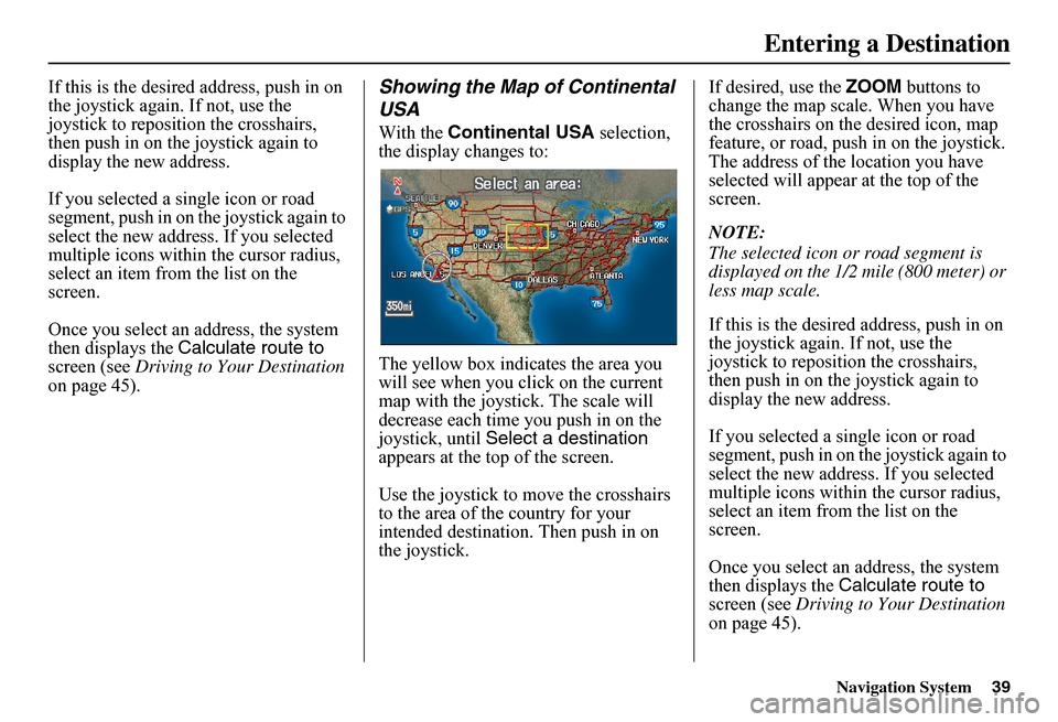
With the Continental USA selection, the display changes to:
The yellow box indi cates the area you will see when you click on the current map with the joystick. The scale will decrease each time you push in on the joystick, until Select a destination appears at the top of the screen.
Use the joystick to move the crosshairs to the area of the country for your intended destination. Then push in on the joystick.
If desired, use the ZOOM buttons to change the map scale. When you have the crosshairs on the desired icon, map feature, or road, push in on the joystick. The address of the location you have selected will appear at the top of the screen.
NOTE:
The selected icon or road segment is displayed on the 1/2 mile (800 meter) or less map scale.
If this is the desired address, push in on the joystick again. If not, use the joystick to reposition the crosshairs, then push in on th e joystick again to display the new address.
If you selected a single icon or road segment, push in on the joystick again to select the new address. If you selected multiple icons within the cursor radius, select an item from the list on the screen.
Once you select an address, the system then displays the Calculate route to screen (see Driving to Your Destination on page 45).
Entering a Destination
Page 47 of 152

46Navigation System
Driving to Your Destination
Changing the Routing Method
The system lets you select the way you want to drive to your destination. Before selecting OK to calculate a route, you can change the routing method by using the CHANGE METHOD scroll bar back ( ) or forward ( ) buttons. The route choices will appear in the address box.
NOTE:
When you are en route and want to change the routing method, press the MENU button, and select Change Routing Method on the Change route by screen.
• “Direct Route” (the factory default) is the route that is the quickest (least time) and is usually the best choice. If you choose any other method, it becomes the new default for all future routing. Make sure to check the routing method if the displayed route is not what you expected to see.
• “Easy Route” produces a route with the least turns.
• “Maximize Freeways,” “Minimize Freeways,” and “Minimize Toll Roads” are also available.
NOTE:
If the trip is greater than 100 miles, then “Minimize Freeways” and “Minimize Toll Roads” may be grayed out. This is normal.
The generated route may not be the route you would choose. For safety reasons, the system generally applies the following rules to your route:
• It tries to avoid shortcuts through residential areas.
• Right turns are favored over left turns or U-turns.
• Restricted turns (turns that cannot be made during certain hours) are not used for routing.
Page 48 of 152

Navigation System47
Viewing the Routes
Touching View Routes on the Calculate route to screen allows you to scroll through and view the various routes (Direct, Easy, Maximize Freeways, etc.) to your destination. If you select View Routes, the display changes to:
NOTE:
You may only view routes as shown above from the Calculate route to screen. The selected route method is shown at the top of the screen.
It may take several minutes (the system displays an hourglass while it is calculating) to show all route methods, and it is not unusual for the different methods to pick the same route. Voice commands cannot be used while the system is calculating. If the trip is greater than 100 miles, then “Minimize Freeways” and “Minimize Toll Roads” may be grayed out. This is normal.
Say or select Summary to display the distance and time to go for each route. Based on the route data, you can change the routing by using the Next and Prev. buttons. Once you confirm your selection, say or select OK on the screen.
NOTE:
Distances and times shown for each method in the Summary are approximate.
After calculating the route with the new method, the system displays a map of your current locatio n. The calculated route will be highlighted as a blue line, and a voice prompt will tell you how to proceed along the highlighted route. Touch VOICE to have the guidance repeated.
Driving to Your Destination
Page 55 of 152
54Navigation System
Driving to Your Destination
Map Scale
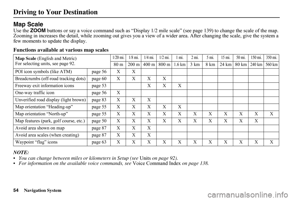
Use the ZOOM buttons or say a voice command such as “Display 1/2 mile scale” (see page 139) to change the scale of the map. Zooming in increases the detail, while zooming out gives you a vi ew of a wider area. After changing the scale, give the system a few moments to update the display.
Functions available at various map scales
NOTE:
You can change between miles or kilometers in Setup (see Units on page 92). For information on the av ailable voice commands, see Voice Command Index on page 138.
Map Scale (English and Metric) For selecting uni ts, see page 92.
1/20 mi. 1/8 mi. 1/4 mi. 1/2 mi. 1 mi. 2 mi. 5 mi. 15 mi. 50 mi. 150 mi. 350 mi.
80 m 200 m 400 m 800 m1.6 km3 km 8 km 24 km 80 km240 km 560 km
POI icon symbols (like ATM) page 56 X X
Breadcrumbs (off-road tracking dots)page60XXXX
Freeway exit information icons page 53 X X X
One-way traffic icon page 56 X
Unverified road display (light brown) page 83 X X X
Map orientation “Heading-up” page55XXXXX
Map orientation “North-up” page55XXXXXXXXXXX
Map features (park, golf course, etc.)page50XXXXXXXXXX
Avoid area shown on map page 87 X X X
Avoid area scales (w hen creating) page 87 X X X
Waypoint “flag” icons page 63 XXXXXXXXXXX
Page 61 of 152
60Navigation System
Driving to Your Destination
Going Off the Route
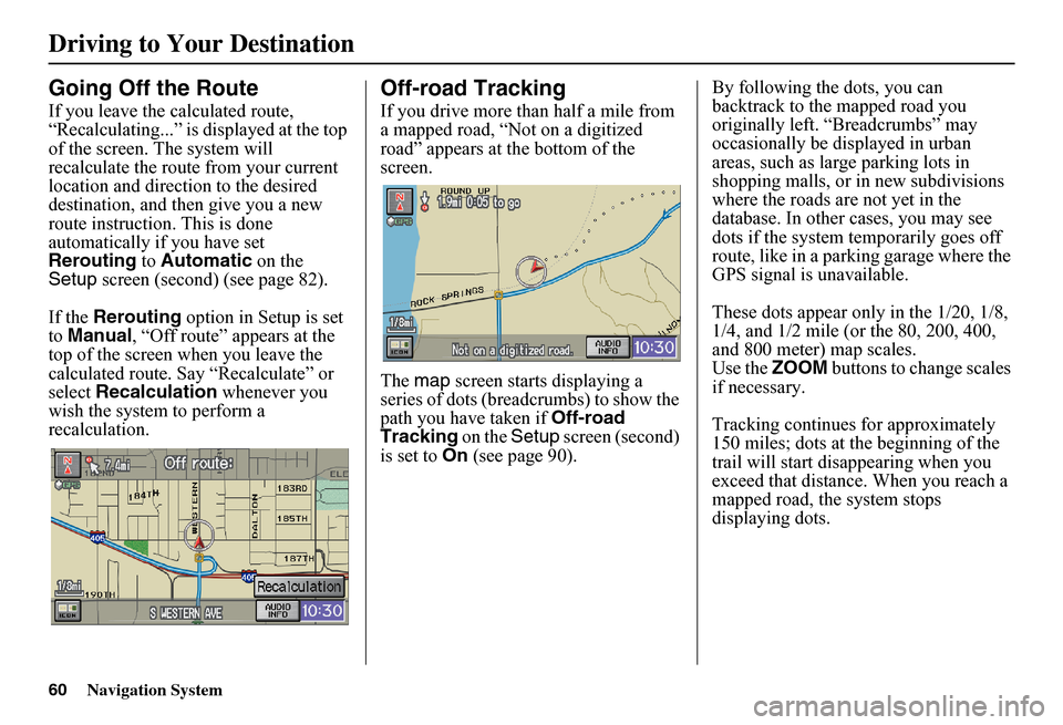
If you leave the calculated route, “Recalculating...” is displayed at the top of the screen. The system will recalculate the route from your current location and direction to the desired destination, and then give you a new route instruction. This is done automatically if you have set Rerouting to Automatic on the Setup screen (second) (see page 82).
If the Rerouting option in Setup is set to Manual, “Off route” appears at the top of the screen when you leave the calculated route. Sa y “Recalculate” or select Recalculation whenever you wish the system to perform a recalculation.
Off-road Tracking
If you drive more than half a mile from a mapped road, “Not on a digitized road” appears at the bottom of the screen.
The map screen starts displaying a series of dots (breadcrumbs) to show the path you have taken if Off-road Tracking on the Setup screen (second) is set to On (see page 90).
By following the dots, you can backtrack to the mapped road you originally left. “Breadcrumbs” may occasionally be displayed in urban areas, such as large parking lots in shopping malls, or in new subdivisions where the roads are not yet in the database. In other cases, you may see dots if the system temporarily goes off route, like in a parking garage where the GPS signal is unavailable.
These dots appear only in the 1/20, 1/8, 1/4, and 1/2 mile (or the 80, 200, 400, and 800 meter) map scales.Use the ZOOM buttons to change scales if necessary.
Tracking continues for approximately 150 miles; dots at the beginning of the trail will start disappearing when you exceed that distance . When you reach a mapped road, th e system stops displaying dots.
Page 72 of 152
Navigation System71
Information Features
You can scroll through the calendar day by day by moving the joystick, or select the day by voice. To change the month, say “Next” or “Previous,” use the ZOOM buttons, or touch the triangles at the top of the screen.
If you say or select List, your entries are listed. Press the CANCEL button to return to the Calendar screen.
Entering Your Schedule
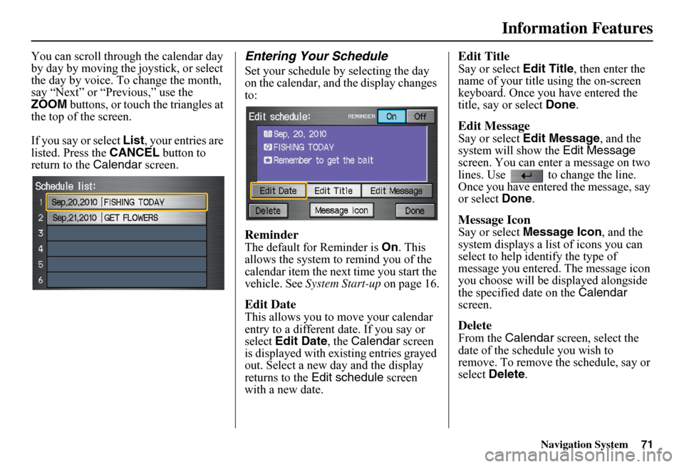
Set your schedule by selecting the day on the calendar, and the display changes to:
Reminder
The default for Reminder is On. This allows the system to remind you of the calendar item the next time you start the vehicle. See System Start-up on page 16.
Edit Date
This allows you to move your calendar entry to a different date. If you say or select Edit Date, the Calendar screen is displayed with existing entries grayed out. Select a new day and the display returns to the Edit schedule screen with a new date.
Edit Title
Say or select Edit Title, then enter the name of your title using the on-screen keyboard. Once you have entered the title, say or select Done.
Edit Message
Say or select Edit Message, and the system will show the Edit Message screen. You can enter a message on two lines. Use to change the line. Once you have entered the message, say or select Done.
Message Icon
Say or select Message Icon, and the system displays a list of icons you can select to help identify the type of message you entered. The message icon you choose will be displayed alongside the specified date on the Calendar screen.
Delete
From the Calendar screen, select the date of the schedule you wish to remove. To remove the schedule, say or select Delete.
Page 88 of 152

Navigation System87
System Setup
Edit Avoid Area
This function allows you to select areas you wish to avoid when calculating a route to your destination. You can select up to five areas to avoid. You may wish to set up an “avoid area” to route around long-term road construction, closures, or any area you wish to avoid. If you enter a route that takes you through or into an “avoid area,” a pop-up box will warn you that your route takes you into one of these areas. However, you can still choose destinations in an avoided area.
When you select Edit for the Setup item “Edit Avoid Area,” the following list screen is displayed:
You can select New Area or select (by touch) one of your existing areas to modify. If you choose New Area, the following screen is displayed:
Say or select Edit Name and use the keyboard to enter the name on the Enter avoid area name screen (19 characters max). Say or select Done to return to the previous screen. Say or select Edit Area to create the area to be avoided. The following screen appears:
Either select Address or Map Input on the Enter avoid area by screen. Each choice provides a slightly different way to locate the approximate map display for drawing the area you wish to avoid. After selecting the choice, a map screen will be displayed.
Use the ZOOM buttons to select the map scale (available scales are 1/20, 1/8, and 1/4 mile scales). Use the joystick to move the crosshairs (red circle) to the desired start point and push in the joystick to “set” the start point. Then move the joystick in a straight or diagonal direction to encompass the area to be avoided.
Page 91 of 152
90Navigation System
System Setup
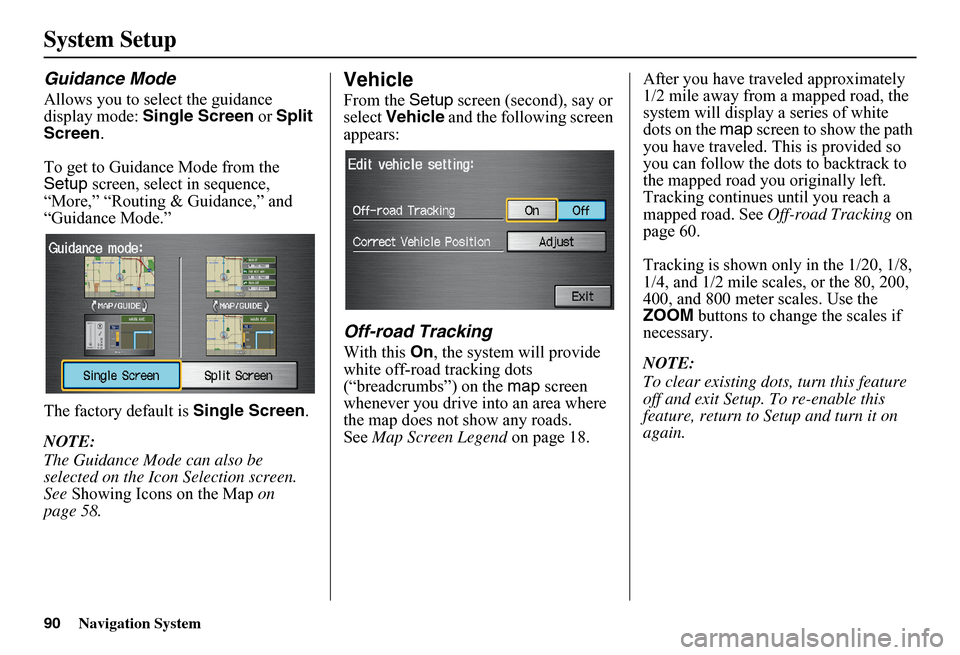
Guidance Mode
Allows you to select the guidance display mode: Single Screen or Split Screen .
To get to Guidance Mode from the Setup screen, select in sequence, “More,” “Routing & Guidance,” and “Guidance Mode.”
The factory default is Single Screen.
NOTE:
The Guidance Mode can also be selected on the Icon Selection screen. See Showing Icons on the Map on page 58.
Vehicle
From the Setup screen (second), say or select Vehicle and the following screen appears:
Off-road Tracking
With this On, the system will provide white off-road tracking dots (“breadcrumbs”) on the map screen whenever you drive into an area where the map does not show any roads.See Map Screen Legend on page 18.
After you have traveled approximately 1/2 mile away from a mapped road, the system will display a series of white dots on the map screen to show the path you have traveled. This is provided so you can follow the dots to backtrack to the mapped road you originally left. Tracking continues until you reach a mapped road. See Off-road Tracking on page 60.
Tracking is shown only in the 1/20, 1/8, 1/4, and 1/2 mile scales, or the 80, 200, 400, and 800 meter scales. Use the ZOOM buttons to change the scales if necessary.
NOTE:
To clear existing dots , turn this feature off and exit Setup. To re-enable this feature, return to Setup and turn it on again.